

Main Facts
As the month of July gives way to August 2026, the European continent is preparing for its most punishing meteorological event of the year. Propelled by a classic, textbook atmospheric Omega block, a monstrous and long-lasting "Heat Dome" is surging northward from North Africa. This severe weather anomaly is locking its grip over Western Europe, Central Europe, and the Mediterranean basin, marking the fourth major heatwave of the 2026 summer season.
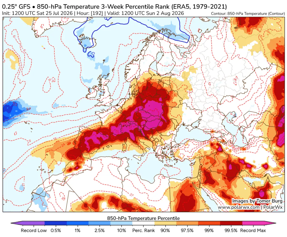
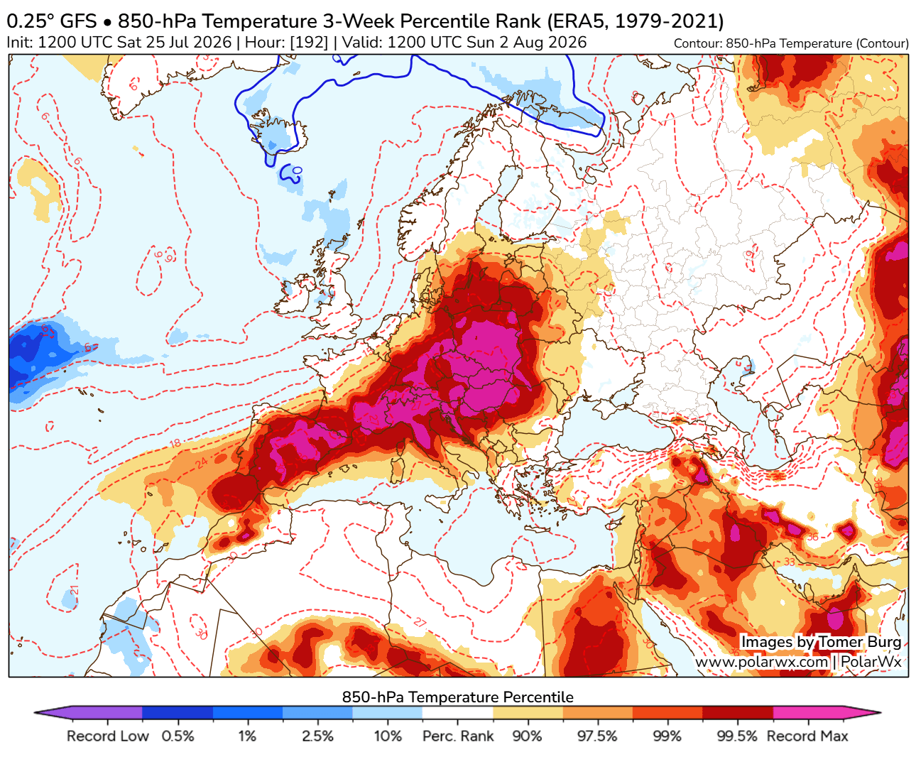
High-resolution global ensemble weather models indicate that mid- to upper-air thermal anomalies are tracking well into the 99th percentile. This puts vast swathes of the continent on course for historic, record-challenging temperatures. Unlike previous heat events earlier this summer, this iteration is expected to be more extensive, longer-lasting, and severely more intense, threatening public health, critical infrastructure, agriculture, and ecosystems already strained by compounding droughts.

The primary epicenter of this atmospheric furnace initially centers over the Iberian Peninsula and France before migrating eastward toward Central Europe, the Balkans, and Eastern Europe. With relative humidity plunging below 20% in many regions and overnight temperatures offering virtually no relief—frequently remaining in the mid-to-upper 20s Celsius—the setup creates a dangerous, high-stress environment for millions of residents and holidaymakers alike.
Chronology of the Event: The Evolution of the 2026 Omega Block
The progression of this weather anomaly follows a distinct spatial and temporal timeline across the European landscape:
Mid-Week (Tuesday and Wednesday): Western Europe and the British Isles
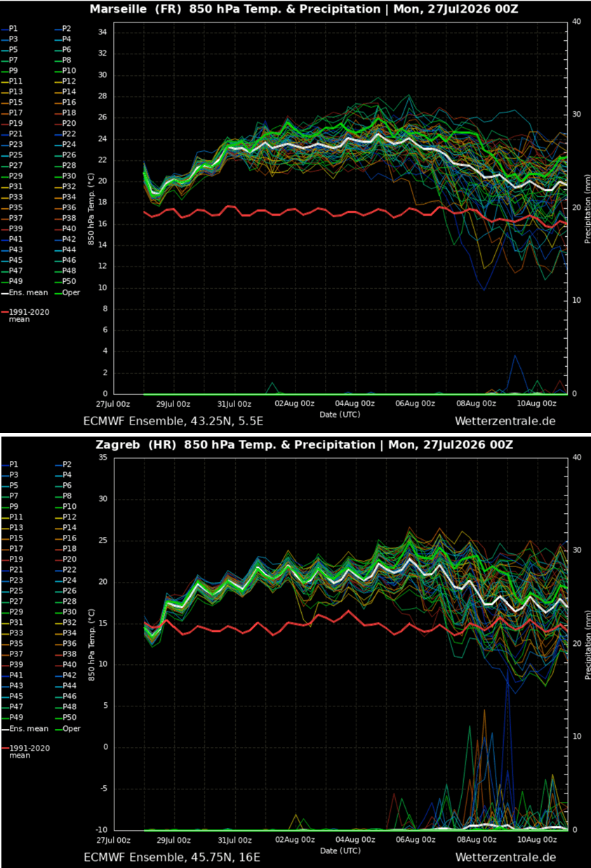
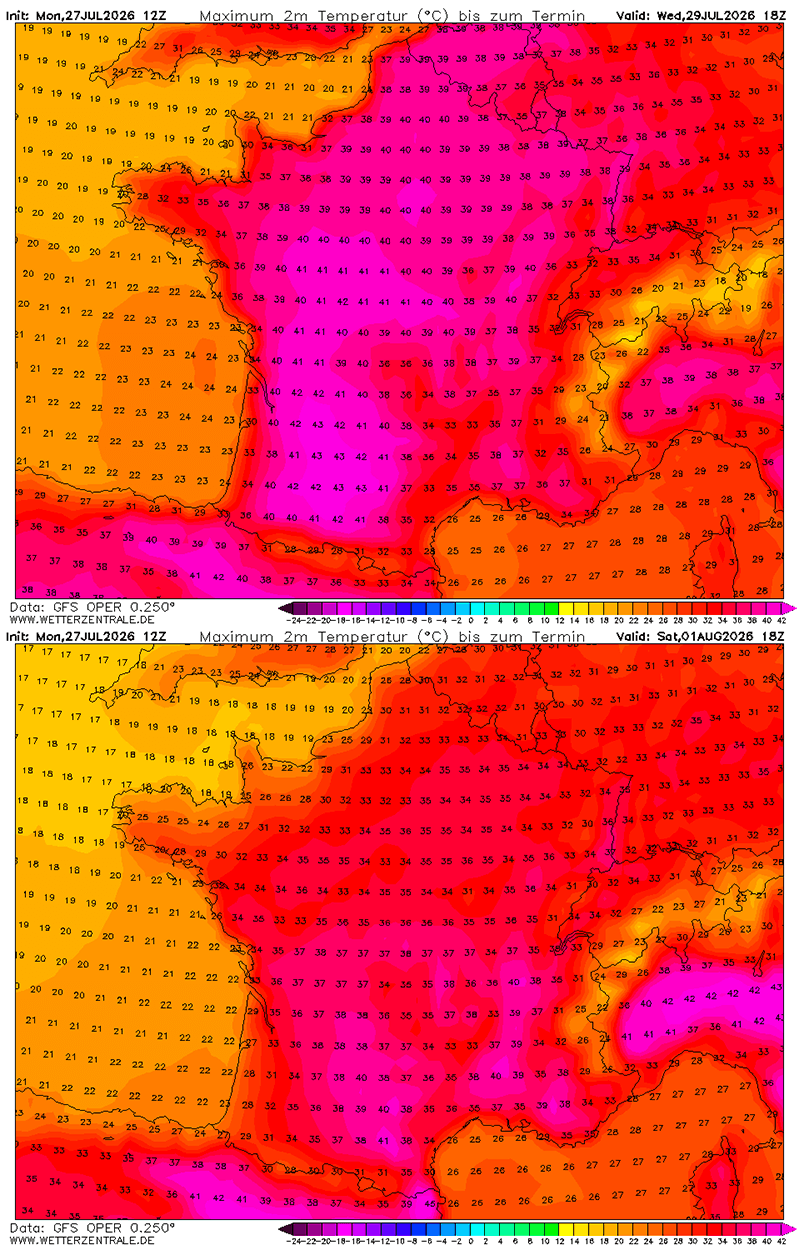
The heatwave aggressively ramps up at the beginning of the week. France bears the brunt of the early surge on Wednesday, with western and central departments expected to record staggering temperatures between 40°C and 43°C. The rest of France anticipates peak afternoon highs ranging from 34°C to 39°C.
Simultaneously, the British Isles experience a sharp, albeit short-lived, spike in temperatures. Tuesday and Wednesday mark the peak for the UK and Ireland, with south-central England reaching 33°C to 36°C, driven by the expanding upper-level ridge before maritime air from the Atlantic forces a cooldown later in the week.
In Germany, the Benelux union, and parts of Poland, the most oppressive conditions hit between Wednesday and Thursday, pushing mercury levels into the upper 30s, with isolated spots touching 40°C to 41°C.
Late Week (Thursday to Friday): Iberia and Central Europe
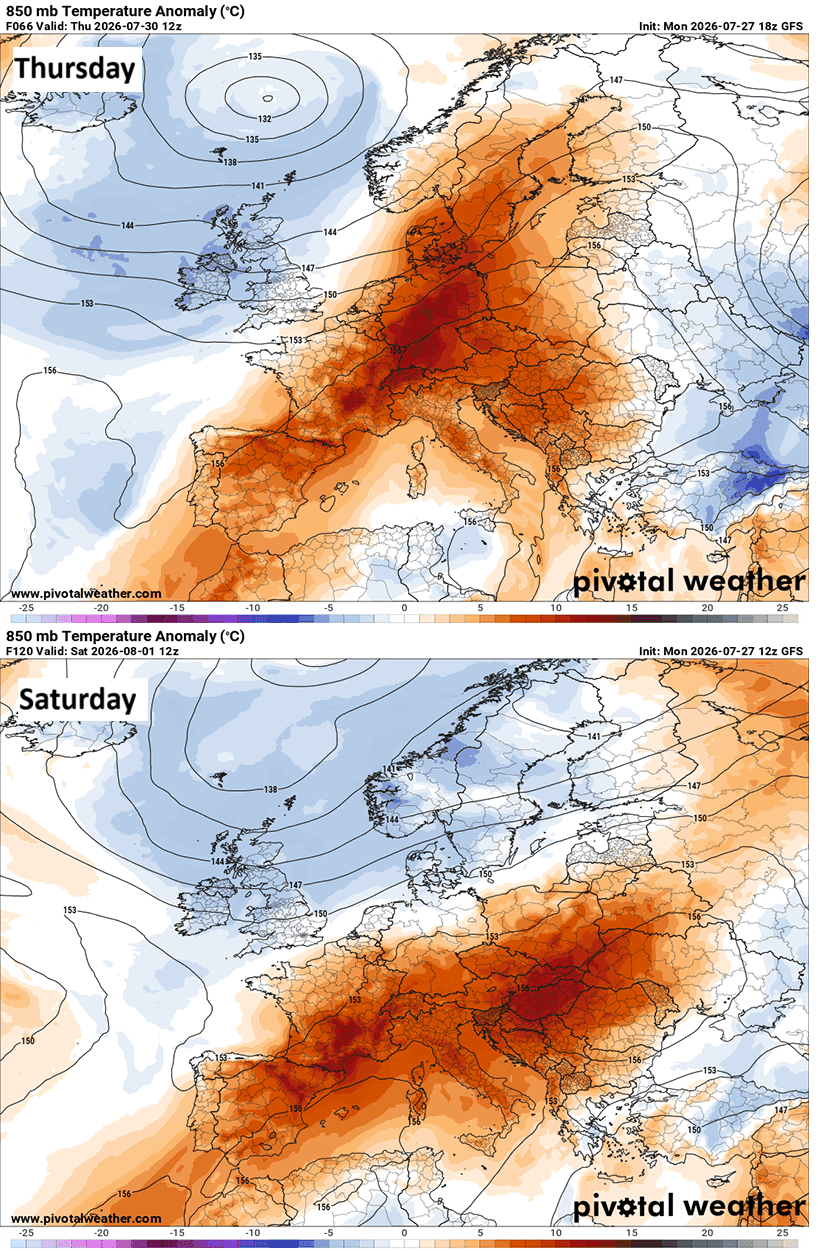
By Thursday and Friday, the core of the heat shifts and intensifies over the Iberian Peninsula. Southern Portugal and south-central Spain face brutally hot conditions, with peak temperatures projected to reach an unbearable 42°C to 46°C in heat-prone lowlands under exceptionally dry air.
Simultaneously, the atmospheric ridge expands eastward, dragging 40°C+ readings into north-central Italy, the Pannonian plains, and parts of Central Europe, including Austria, the Czech Republic, and Slovakia.
The Weekend into Early August: The Balkans and Eastern Europe
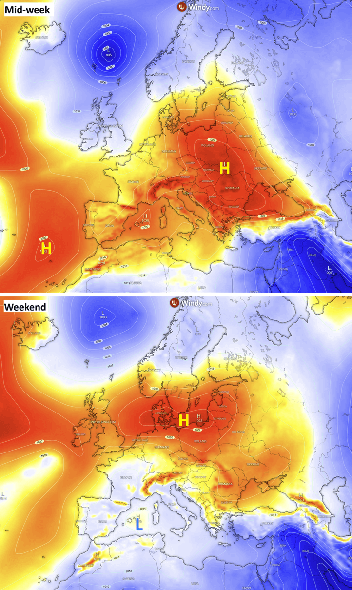
As the weekend arrives and August begins, the center of the surface High shifts toward Germany, Denmark, and the Baltic region, while lower pressure establishes over the Mediterranean. This creates an east-northeast flow, pumping exceptionally dry continental air toward the Mediterranean and the Balkans.
Countries including Hungary, western Romania, northern Bosnia & Herzegovina, north-central Serbia, Slovenia, and Tuscany in Italy face multiple consecutive days of temperatures exceeding 40°C. By Sunday, the extreme heat mass spills further east into Ukraine, Moldova, and Western Russia, where temperatures will climb toward 40°C, sustaining dangerous conditions well into the following week.
Supporting Data and Meteorological Mechanics
To understand the severity of the 2026 event, meteorologists look to several key atmospheric indicators:
The Mechanics of the Heat Dome and Omega Block
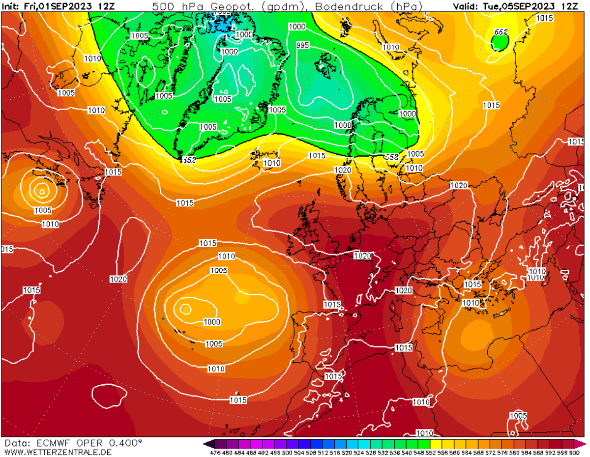
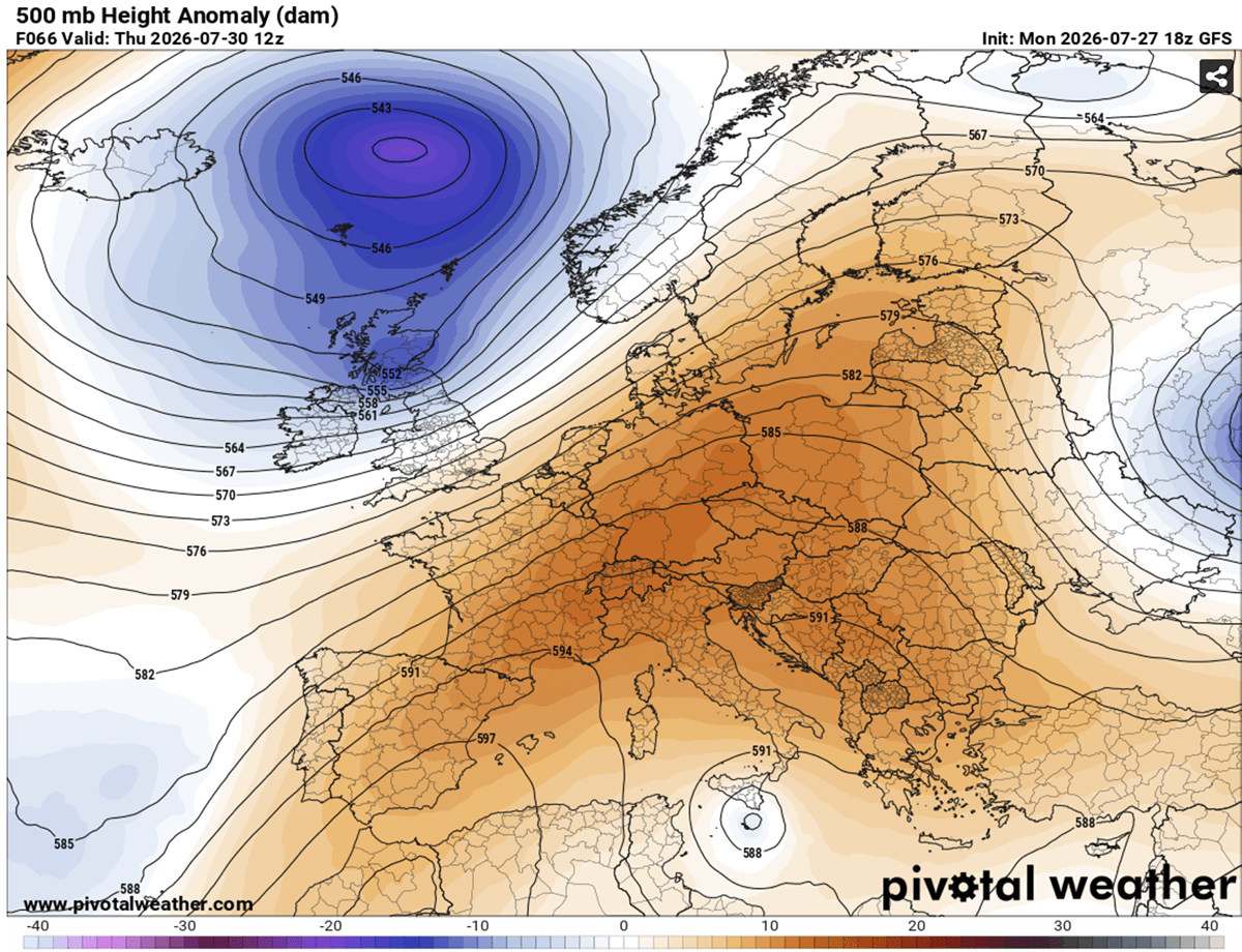
The large-scale pattern resembles an Omega block, featuring a dominant blocking High-pressure system parked over the heart of Europe, flanked by deep low-pressure systems over the North Atlantic and Russia.
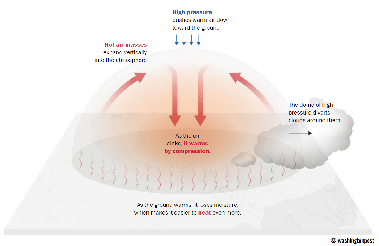
A Heat Dome functions essentially like a lid on a pot. The upper-level ridge (or Upper High) traps a massive reservoir of warm air at all levels, causing air masses to sink toward the ground. This downward compression warms the air adiabatically, creating anomalously high temperatures at low elevations and extreme heat at the surface.
Thermal Anomalies Aloft
- 500 mbar Geopotential Heights: Ensemble guidance from the ECMWF (European Centre for Medium-Range Weather Forecasts) and GFS (Global Forecast System) indicates that geopotential heights will reach near-record levels for late July, reflecting a deeply anomalous tropospheric setup driven by subtropical air expansion.
- 850 mbar Temperatures: Weather models project temperatures at the 850 mbar level (approximately 1,500 meters above sea level) to surge into the 24°C to 28°C range across a broad expanse of Europe. In parts of the Mediterranean, sinking air and regional Foehn wind effects could push 850 mbar levels toward an astonishing 30°C.
- Surface Responses: Widespread sea-level pressure rises accompany the upper-level High, establishing a weak-wind environment initially, followed by dry, gusty east-northeast flows that exacerbate surface heating and dry out vegetation.
Implications: Public Health, Infrastructure, and Wildfire Crisis
The meteorological data translates directly into severe real-world hazards, impacting multiple sectors of European society.
Human Health and "Tropical Nights"
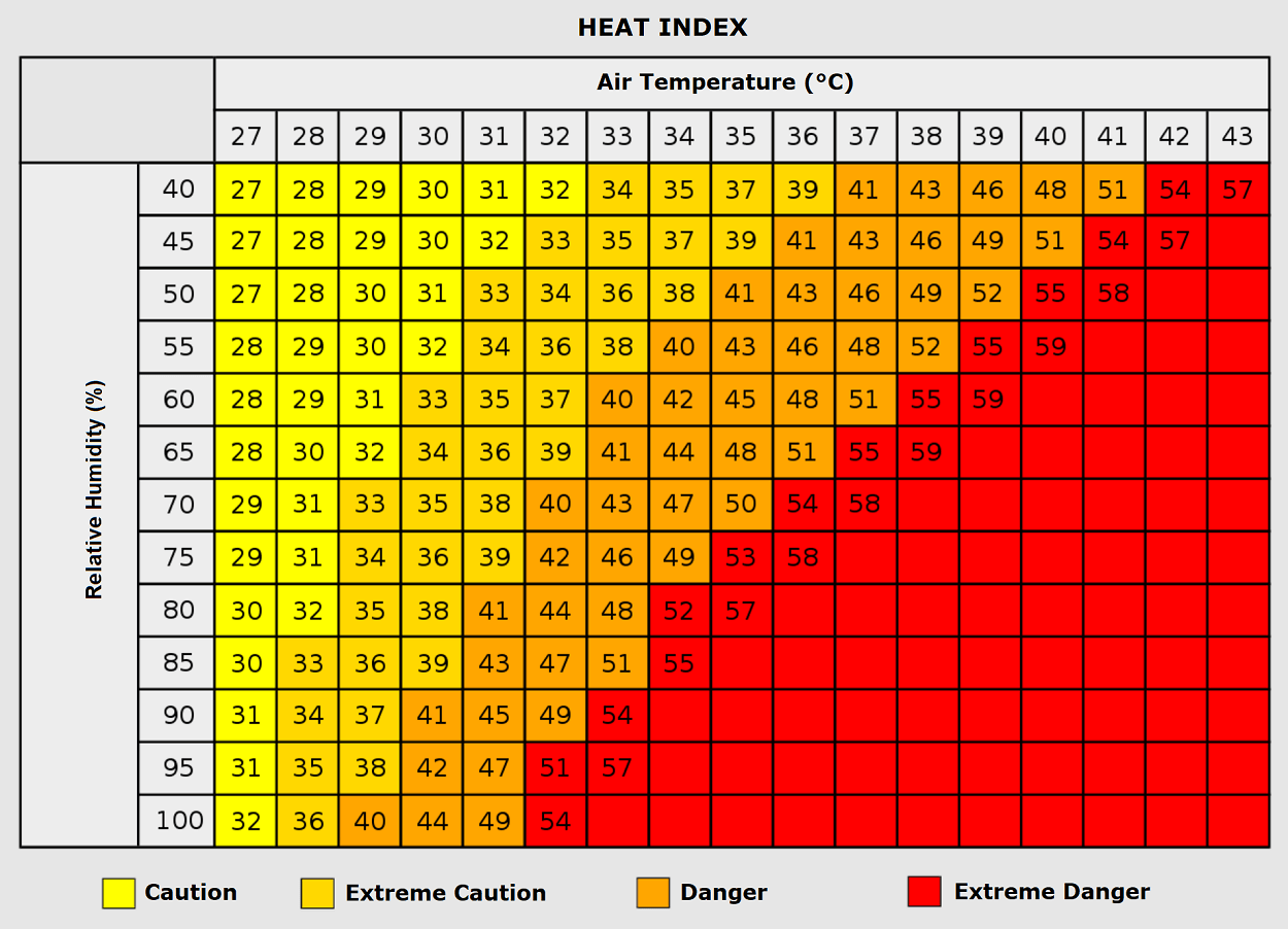
Extreme heat is frequently described as a "silent killer," and the human toll of this current dome has already begun to manifest. A major risk factor during this event is the prevalence of suffocating "tropical nights," where overnight temperatures fail to drop below 24°C. Without this vital thermal window to cool down, the human body suffers cumulative physiological stress.
Because centralized residential air conditioning remains relatively rare across much of Western and Central Europe, emergency medical services are bracing for an influx of patients suffering from heat exhaustion, dehydration, and life-threatening heat stroke. Furthermore, prolonged exposure to extreme heat spikes the incidence of cardiovascular events, strokes, and respiratory illnesses. Vulnerable populations—including the elderly, young children, individuals with pre-existing medical conditions, and outdoor laborers in construction and agriculture—face disproportionate risks.
The Wildfire Emergency
Compounding the atmospheric crisis is an escalating ecological disaster. Tinder-dry forests across Spain, southern France, and parts of Italy are already under extreme wildfire risk.
As the dry heat expands across Central Europe, relative humidity levels plunging well below 20% create explosive wildfire conditions. Combined with moderately strong, dry winds, the risk of rapid, uncontrollable wildfire ignition and spread is critically high across the Alpine region, the Balkans, and the Mediterranean. Firefighting agencies remain on high alert as the threat level reaches maximum thresholds.
Official Responses and Outlook
Emergency management agencies, meteorological institutes, and civil protection authorities across the affected nations have issued widespread red and orange weather warnings. Governments are ramping up public cooling centers, issuing health advisories encouraging hydration and reduced outdoor activity, and restricting access to high-risk forest zones to prevent accidental fire ignitions.
Meteorologists will continue to monitor the progression of this fourth major heatwave of 2026. With indications that the blocking pattern may persist and potentially re-expand toward mid-August, authorities urge residents and tourists to follow local forecasts closely and adhere strictly to safety guidelines as Europe navigates one of its most challenging summer weather episodes on record.
