

Every autumn, weather forums, social media platforms, and amateur meteorology blogs light up with a singular, persistent question: Is snow spreading rapidly across Siberia? For well over a decade, a popular school of thought among weather enthusiasts has held that an early, fast-moving October snow advance across Eurasia serves as a reliable crystal ball—an early warning sign of a severe, brutally cold, and snowy winter for the United States, Canada, and Europe.
This widely cited theory stems from a landmark 2011 scientific study. Yet, with another rapid snow surge forecast for October, modern data analytics allow us to ask a critical question: Does the Siberian snow indicator still hold up, or has climate change and atmospheric evolution rendered it a meteorological myth?
Analyzing 47 winters of data spanning from 1979 to 2025 across four distinct snow datasets yields surprising results. These findings fundamentally challenge how meteorologists and enthusiasts alike should interpret October snow cover as we look ahead to the winter of 2026/2027.
Main Facts: The Anatomy of the Siberian Snow Theory
To understand why the debate over Eurasian snow cover persists, one must examine the physical mechanics behind the original 2011 hypothesis proposed by scientists Judah Cohen and Justin Jones.
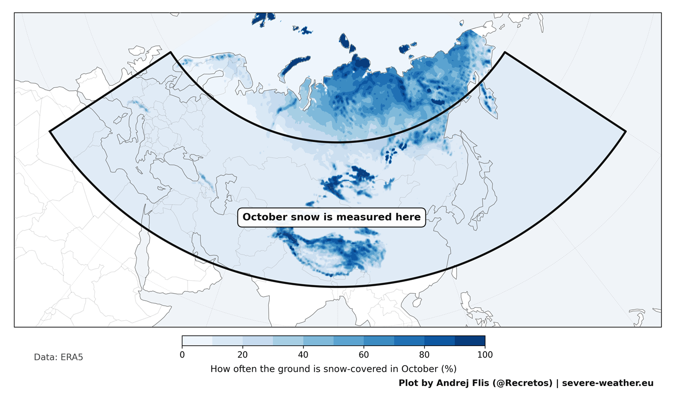
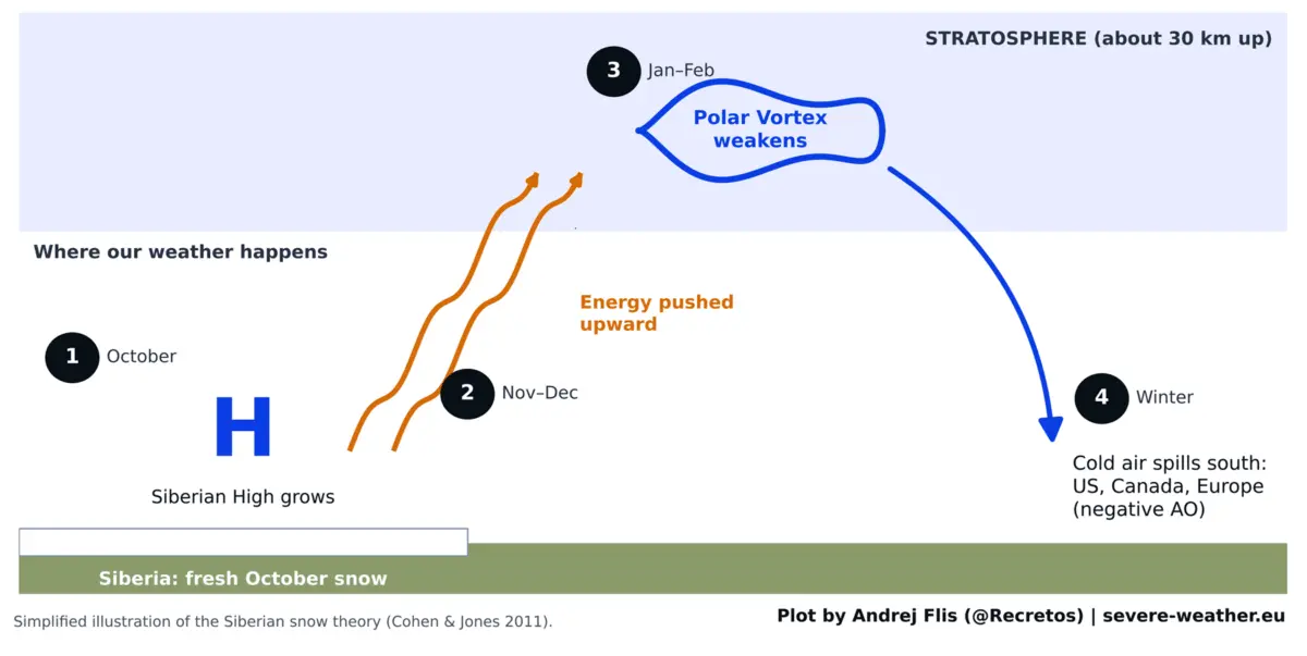
The core premise is straightforward: when snow cover expands rapidly across Eurasia during October—a massive geographic expanse stretching from Western Europe to the Pacific coast, concentrated heavily in southern Siberia, Mongolia, and the Tibetan Plateau—it profoundly cools the ground. This cooling strengthens the Siberian High, a massive, semi-permanent area of cold, heavy air situated over northern Asia.
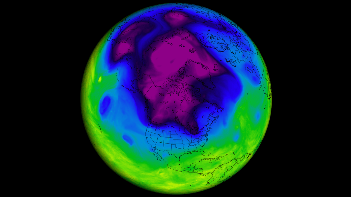
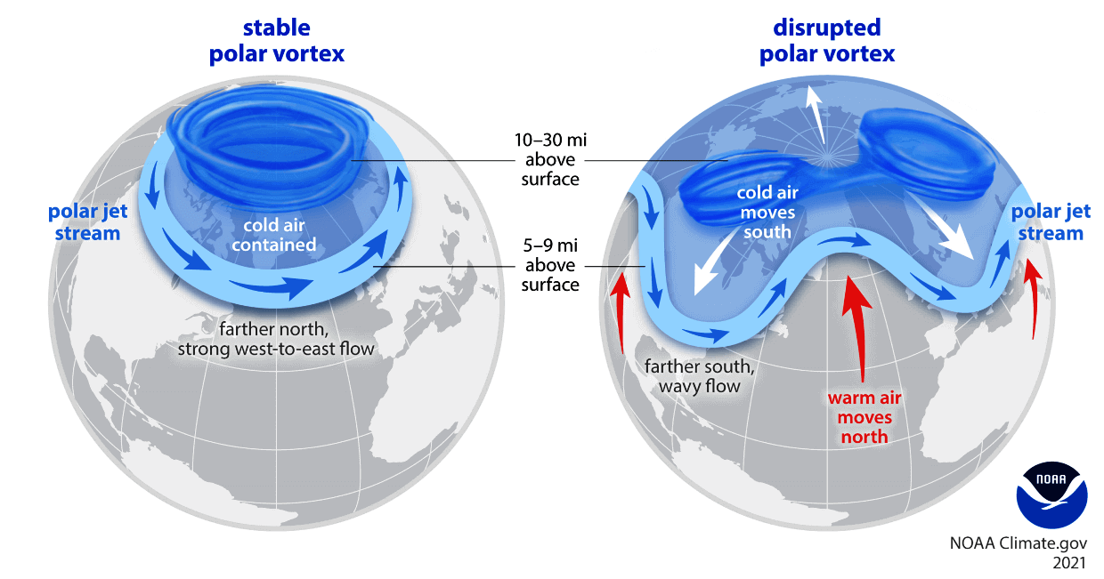
The strengthening of this high-pressure system triggers a vertical atmospheric response. It pumps excess planetary wave energy upward into the stratosphere, roughly 18.5 miles (30 km) above the Earth’s surface. Once this energy reaches the stratosphere, it disrupts and weakens the Polar Vortex—the colossal ring of strong westerly winds that typically traps the coldest Arctic air in a tight circle around the North Pole.
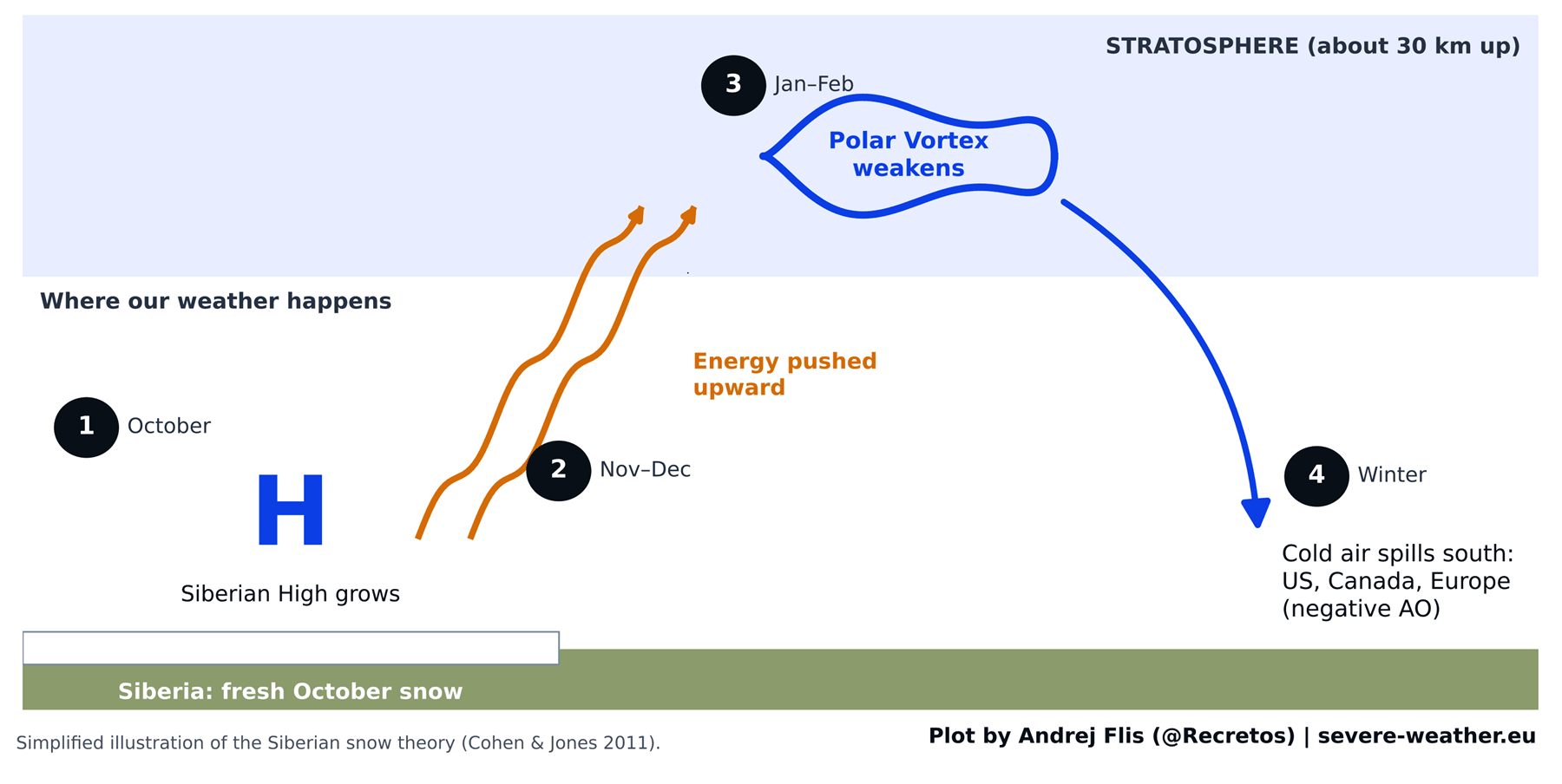
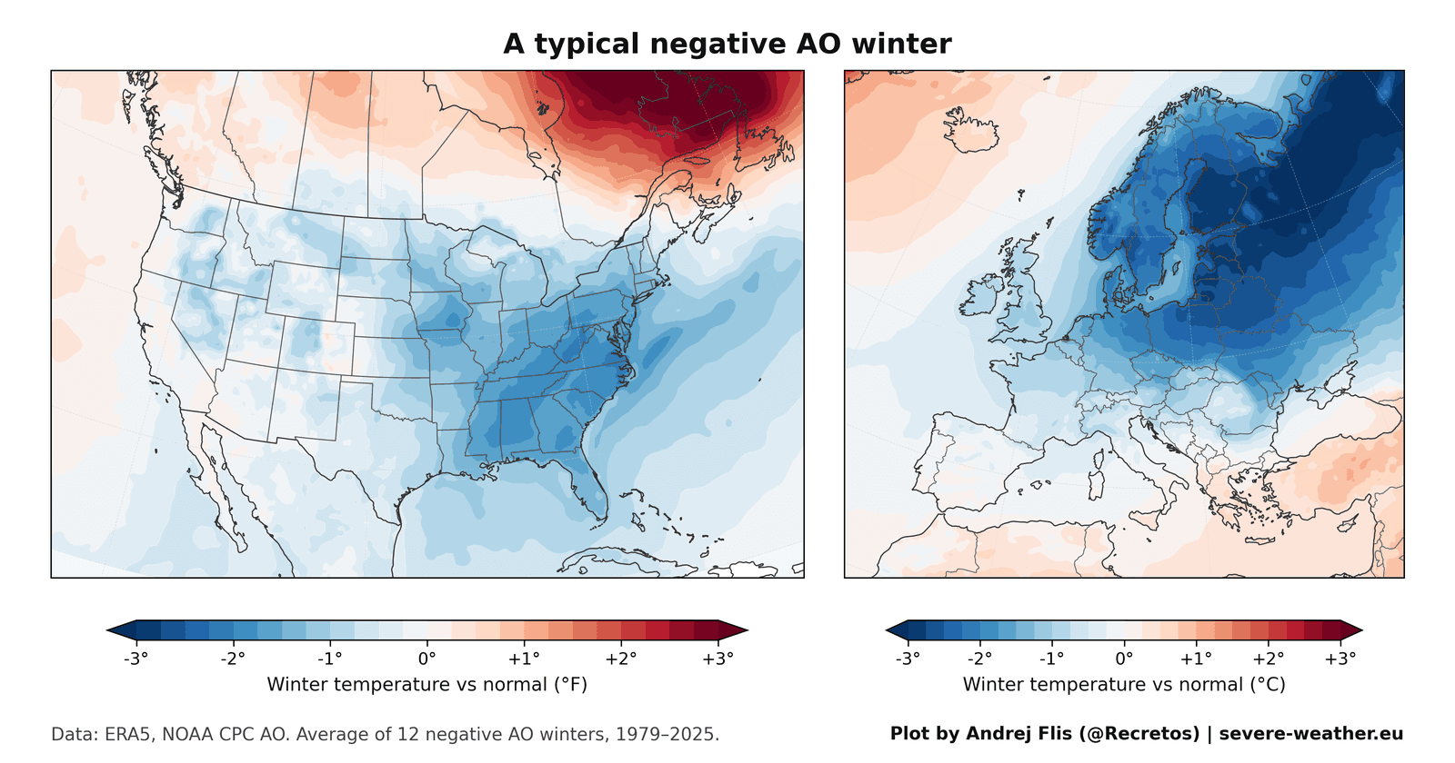
When the Polar Vortex remains strong and stable, winter weather in the mid-latitudes tends to be relatively mild. However, when the vortex becomes stretched, wobbly, or collapses entirely, lobes of bitter Arctic air break away, spilling southward into North America and Europe. Meteorologists quantify this behavior using the Arctic Oscillation (AO) index. A positive AO locks cold air in the Arctic, while a negative AO facilitates severe southward outbreaks of cold air and heavy snowfall.
Chronology: From Scientific Breakthrough to Fading Signal
The Genesis (1997–2010)
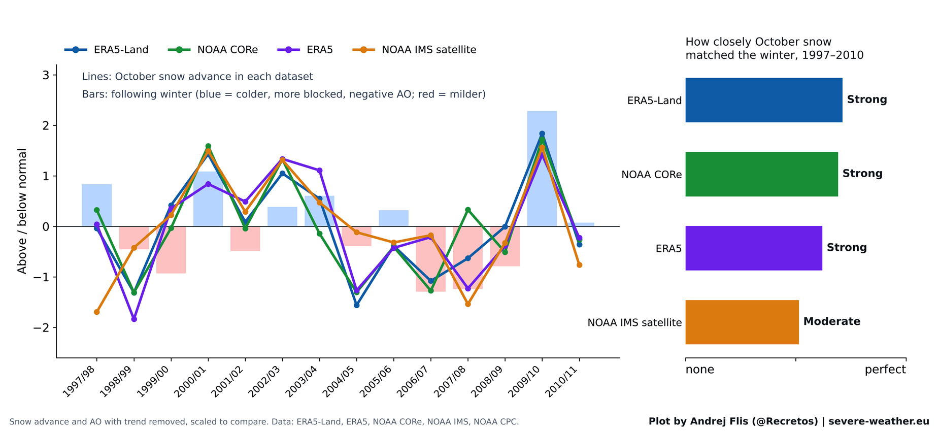
When Cohen and Jones published their research in 2011, the correlation between rapid October snow advance and a subsequent negative winter AO was remarkably robust. However, those foundational years relied primarily on daily satellite snow maps that only extended back to 1997, leaving the researchers with a baseline of just 14 winters.
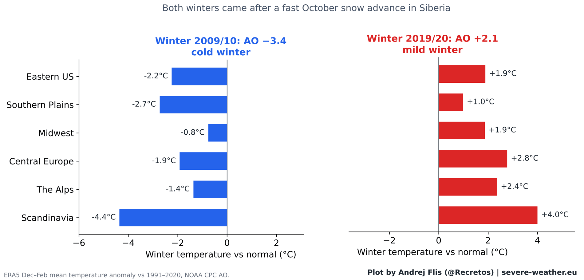
During this initial study window, the theory performed admirably. It successfully anticipated high-profile events, most notably the winter of 2009/2010. That season followed one of the fastest October snow advances on record and culminated in the most negative AO recorded up to that time, delivering historic cold to Europe and crippling February 2010 snowstorms across the Eastern United States.
The Post-2011 Divergence
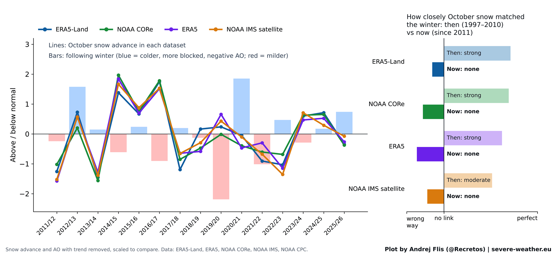
To rigorously test the theory, a comprehensive audit of the subsequent 15 winters (plus historical records stretching back to 1979) was conducted using four independent snow datasets: NOAA IMS, NOAA CORe, ERA5, and ERA5-Land.
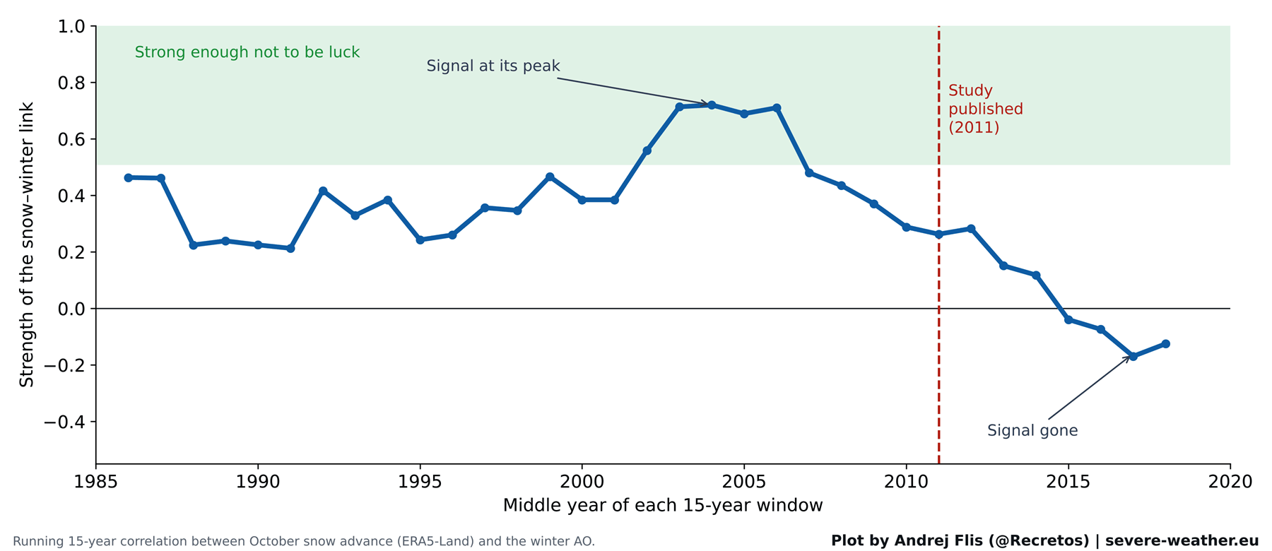
While all four datasets confirmed that the original 1997–2010 correlation was statistically sound—proving the original authors made no data errors—the predictive signal abruptly flatlined after 2011. Moving averages of forecast strength reveal that the snow-to-winter link peaked sharply in the early-to-mid-2000s and has steadily degraded ever since, occasionally inverting entirely.
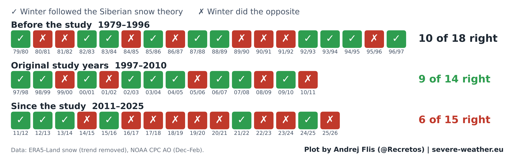
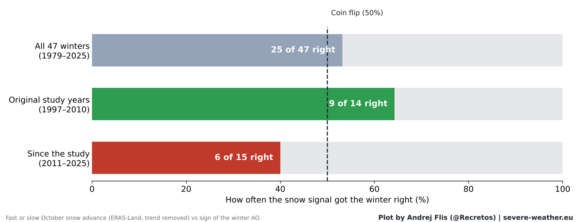
Out of 47 total winters evaluated between 1979 and 2025, the October snow signal correctly anticipated the winter AO outcome 25 times and failed 22 times—essentially performing no better than a coin flip. Worse still, in the 15 winters following the 2011 publication, the index was correct only 6 times, performing worse than random chance. As a stark counterexample, the winter of 2019/2020 followed a rapid October snow advance yet yielded one of the strongest positive AO phases and warmest winters on record across Europe and large parts of the U.S.
Supporting Data: Dissecting the Atmospheric Chain Reaction
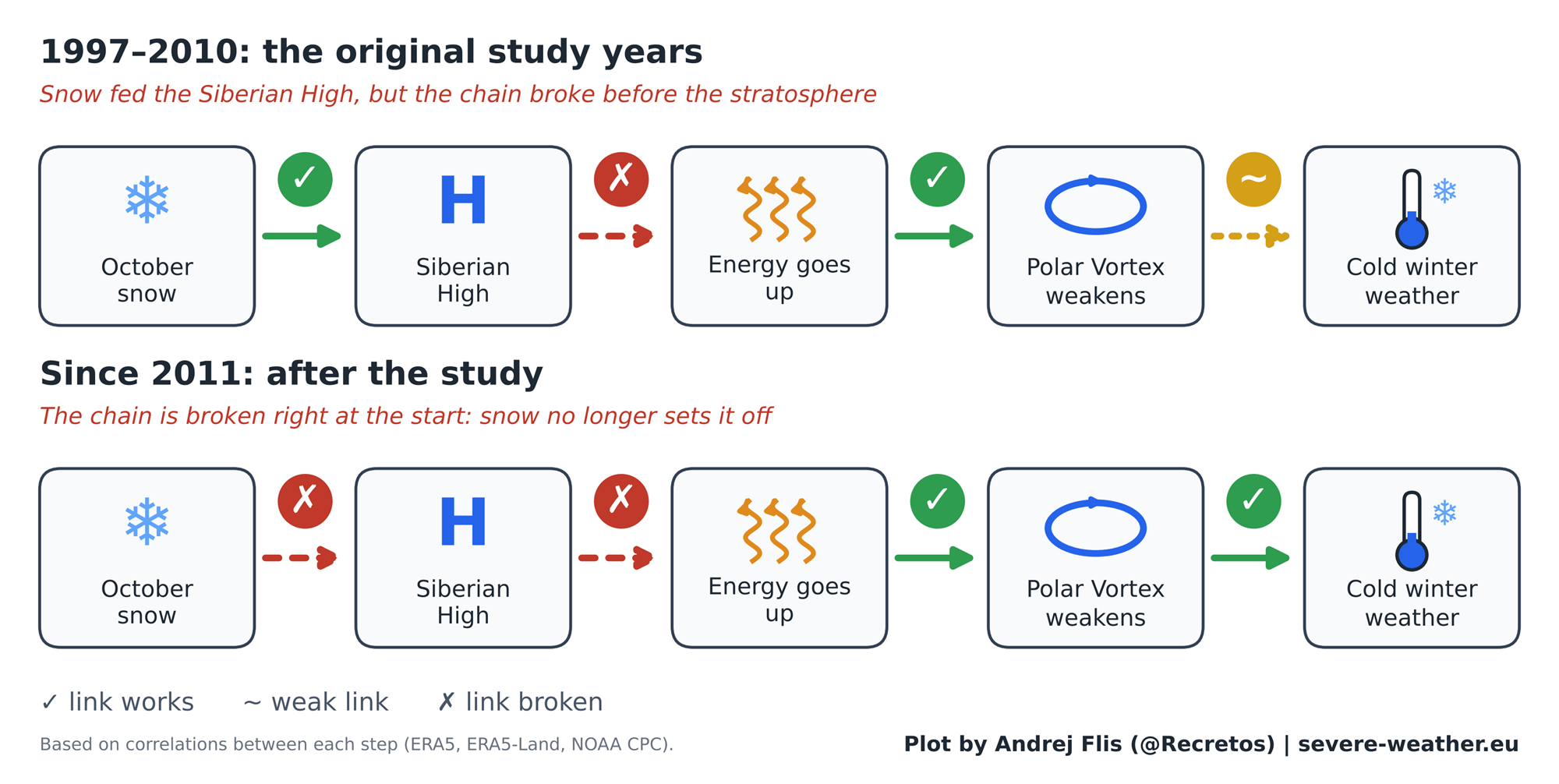
Why did a theory backed by sound physical principles lose its predictive edge? Step-by-step diagnostic testing of the atmospheric chain reaction provides the answer.
[October Eurasian Snow] ---> [Siberian High Pressure] ---> [Stratospheric Upward Energy] ---> [Polar Vortex Disruption] ---> [Winter Weather (AO)]
        (Broken Link)             (Weakened Link)              (Consistently Valid)            (Consistently Valid)          (Unreliable Outcome)
The data reveals a critical fracture at the beginning of the chain. While the latter half of the sequence remains intact—meaning that whenever excess energy successfully propagates into the stratosphere in November and December, the Polar Vortex does reliably weaken in January and February—the initial trigger (October Siberian snow) no longer consistently forces that upward energy wave.
In short, the stratospheric Polar Vortex still responds dynamically to energy from below, but Siberian snow can no longer be relied upon to deliver that energy.
Furthermore, regional impact checks across 11 distinct zones in North America and Europe confirm this breakdown. Prior to 2011, rapid snow advances correlated neatly with colder winters in the eastern U.S. and specific precipitation regimes in Europe. Since 2011, nearly all regional correlations have collapsed to near-zero statistical significance.
Official Responses and Expert Perspectives
Atmospheric scientists point to several compounding factors to explain the breakdown of the Eurasian snow signal. Rapid Arctic sea-ice loss, unprecedented ocean warming, and shifting baselines of the Siberian High have fundamentally altered how the high-latitude atmosphere responds to surface forcing.
Recent research, including a September 2026 study by Songmiao Fan and Judah Cohen, suggests that snowy Eurasian Octobers may still promote specific "stretched" Polar Vortex configurations conducive to long cold spells in the eastern United States. However, these nuanced patterns differ significantly from the broad-brush Arctic Oscillation forecasts previously relied upon.
Moreover, data analysts uncovered an unexpected technical artifact during the research: standard ERA5 reanalysis data exhibits an artificial 40% drop in Eurasian October snow cover around 2004, coinciding with the integration of satellite snow mapping. While cross-referencing with NOAA CORe and satellite-native datasets confirmed that this artifact did not alter the macro-conclusions of the study, it serves as a cautionary tale for researchers relying exclusively on single reanalysis streams.
Implications for Winter 2026/2027
The October 2026 Snow Outlook
As Eurasia enters late October 2026, initial satellite observations and ECMWF forecasts indicate a slow start to the month’s snow cover, followed by a projected surge over the final two weeks. If verified, this rapid accumulation will rank in the top 15% for mid-to-late October snow advances over the past thirty years.
However, historical analogs matching this projected trajectory (such as 2002, 2019, and 2023) produced widely divergent winter outcomes. Consequently, relying on the October snow advance for the upcoming winter is scientifically unjustified.
The Real Driver: The Super El Niño of 2026/2027
Fortunately, long-range forecasters are not flying blind. Winter 2026/2027 is dominated by a much more powerful atmospheric driver: an active, record-challenging Super El Niño in the Pacific basin.
Global sea-surface temperature anomalies clearly highlight this massive El Niño signature, which exerts a far stronger control over the global jet stream, storm tracks, and stratospheric wind patterns than Siberian snow cover.
+-----------------------------------------------------------------+
|              SUPER EL NIÑO 2026/2027 ATMOSPHERIC IMPACT         |
+-----------------------------------------------------------------+
|  1. Amplified Pacific Jet Stream & Active Southern Storm Track  |
|  2. Significant Stratospheric Wind Deceleration (Dec/Jan)       |
|  3. Increased Probability of Sudden Stratospheric Warming (SSW) |
+-----------------------------------------------------------------+
ECMWF seasonal simulations of zonal winds at the 10mb level in the stratosphere reveal a marked deceleration of the Polar Vortex starting in late December and extending through January and February 2027. This modeled slowdown strongly hints at an impending Sudden Stratospheric Warming (SSW) event—a complete reversal of polar winds and a subsequent breakdown of the vortex.
Regional Expectations for North America and Europe
When a major stratospheric disruption occurs during a strong El Niño background state, historical modeling and current ECMWF forecasts point toward distinct geographic outcomes for the upcoming winter:
- United States & Canada: The projected mid-to-late winter pattern favors a classic "Polar Express" configuration. The ECMWF February 2027 temperature outlook highlights a colder-than-average anomaly trend across the central, southern, and eastern United States, driven by persistent cloud cover, enhanced precipitation, and an amplified southern jet stream. Meanwhile, northern tiers and parts of Canada are projected to lean milder.
- Europe: Current seasonal model runs indicate a predominantly mild, westerly flow dominating much of the European continent into late winter, with colder anomalies largely restricted to extreme northern Scandinavia. Unlike North America, Europe does not currently display the classic surface-cold response to the forecasted weak vortex, meaning American interests face a higher statistical probability of impactful winter weather episodes.
Conclusion
The tradition of scanning Siberian satellite maps every October to forecast winter weather makes for compelling discussion, but 47 years of empirical data demonstrates that the snow advance theory is no longer a reliable forecasting tool. As winter 2026/2027 approaches, forecasters will bypass the Eurasian snow cover index, focusing instead on real-time stratospheric wave energy transfer and the potent atmospheric teleconnections driven by the Pacific Super El Niño.
