

NEW YORK/DOVER, DELAWARE — Recovery operations and damage assessments went into full swing on Friday across the Northeast corridor, following a violent round of severe weather that unleashed torrential downpours, triggered widespread flash flooding, and spawned confirmed tornadoes in both Delaware and New York.
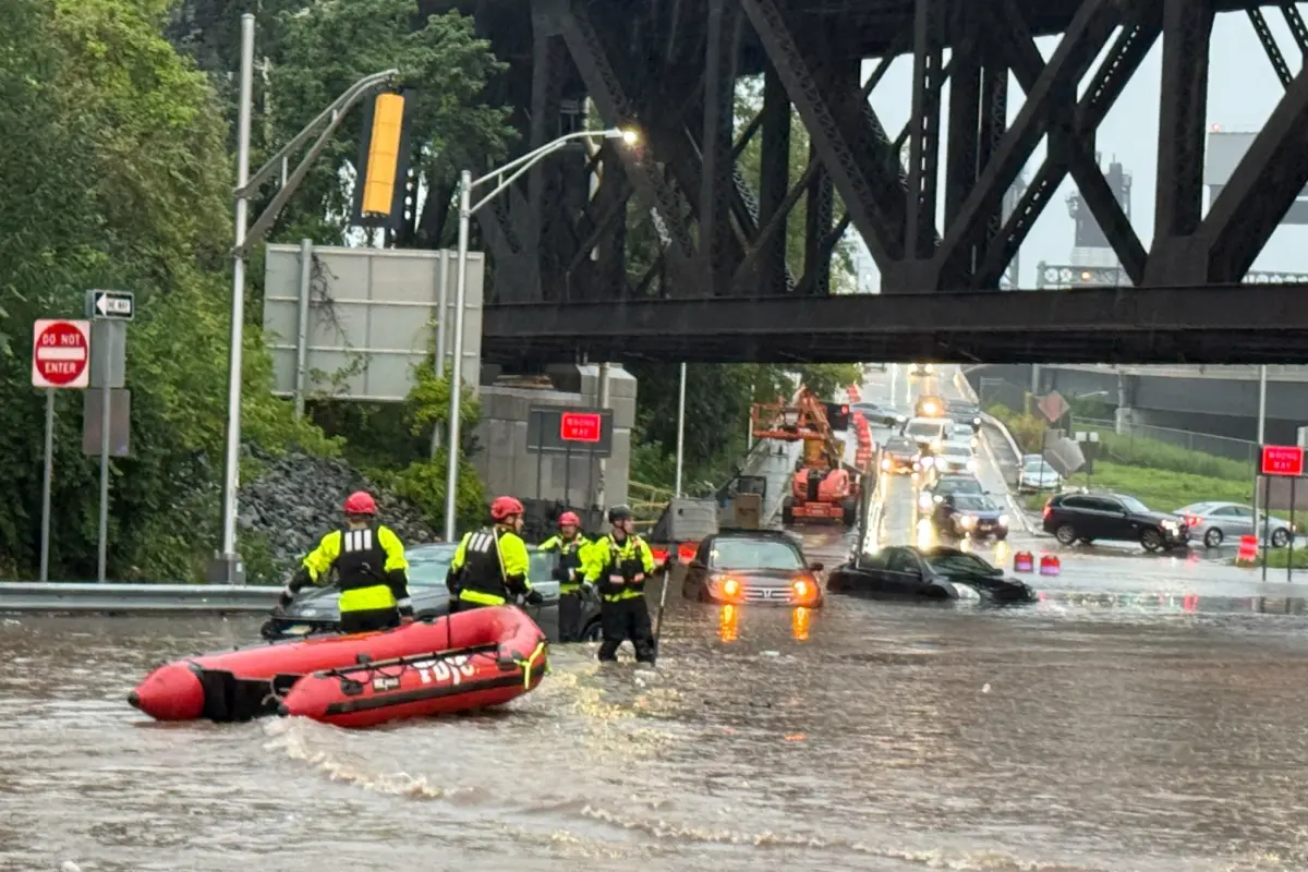
The powerful storm system, which swept across the region on Thursday, left behind a trail of uprooted trees, structural devastation, and submerged roadways. Dozens of motorists were caught unawares by rapidly rising floodwaters, requiring dramatic high-water rescues by emergency personnel using inflatable boats and heavy-duty vehicles.
Despite the widespread destruction, transportation gridlock, and property damage, local authorities confirmed a stroke of incredible fortune: as of Friday morning, there were no reports of serious injuries or fatalities resulting from either the tornadoes or the catastrophic flash floods.
Meteorological teams from the National Weather Service (NWS) deployed to the affected zones on Friday to conduct comprehensive ground surveys, analyze radar data, and determine the exact wind speeds, strengths, and precise paths of the tornadoes that struck the mid-Atlantic and Long Island.
Main Facts
The severe weather outbreak struck a broad swath of the Northeast, packing a double punch of destructive tornadic winds and torrential rainfall rates that overwhelmed local municipal drainage systems.
Key details of the disaster include:
- Tornado Confirmations: The National Weather Service verified that tornadoes touched down in two distinct locations: Dover, Delaware, and Atlantic Beach on Long Island, New York. The Long Island event originated as a waterspout over the Atlantic Ocean before moving ashore.
- Structural Devastation: In Dover, severe winds ripped the roof off a local motel and damaged neighboring commercial structures along Route 13. On Long Island, beach club structures were torn apart by the vortex.
- Mass Rescues: Flash flooding trapped dozens of motorists across the tri-state area. In Jersey City, New Jersey, alone, emergency crews rescued 69 people from stranded cars using inflatable rescue boats. In Nassau County, New York, first responders executed multiple water extractions.
- Infrastructure Disruptions: High water forced the complete closure of the Long Island Expressway in Queens in both directions. Municipal services, power grids, and local transportation networks faced severe bottlenecks.
- Casualties: Miraculously, despite the severity of the structural impacts and vehicular entrapments, no critical injuries or deaths have been reported.
Chronology of the Storm
The escalation from standard summer convective activity to a full-scale natural disaster unfolded rapidly over the course of Thursday, catching many residents during the afternoon and evening commutes.
Thursday Afternoon: The Threat Materializes
As a moisture-rich, unstable air mass collided with an advancing cold front, dark storm clouds rapidly built across the mid-Atlantic and Northeast. By mid-afternoon, the Storm Prediction Center’s alerts prompted local meteorologists to issue severe thunderstorm and tornado warnings.
Thursday Late Afternoon: Tornadoes Touch Down
At approximately the height of the storm cell’s passage, a trained weather spotter reported a tornado touchdown in Dover, Delaware. The violent rotational winds targeted commercial corridors, tearing roofs away and scattering debris across thoroughfares.
Simultaneously, residents along the south shore of Long Island witnessed a rare phenomenon. A waterspout formed over the chilly waters of the Atlantic Ocean, tracking northward before making landfall in Atlantic Beach. The brief but intense vortex tore through beach club facilities, flinging debris and alarming beachgoers and coastal residents.
Thursday Evening: The Deluge and Flash Flooding
As the squall line marched northeastward, its forward motion slowed, allowing torrential rain to dump staggering amounts of water in remarkably short windows of time. Urban drainage systems proved entirely inadequate for the sudden influx.
Flash flooding materialized rapidly across New York City, Long Island, and northern New Jersey. Motorists navigating evening traffic found themselves marooned as water levels surged over hoods within minutes. In Queens, water pooled so deeply on the Long Island Expressway that authorities had to halt all traffic in both directions.
Across the Hudson River in Jersey City, the situation deteriorated rapidly as low-lying streets turned into navigable rivers, trapping dozens of vehicles and compelling a massive municipal rescue response that stretched late into the evening hours.
Friday Morning: Assessment and Reopening
By daybreak Friday, the storm system had pushed out to sea, leaving behind crisp, clear skies that contrasted sharply with the localized devastation left in its wake. Municipal leaders wasted no time enacting emergency protocols, lifting temporary emergency declarations as daylight revealed the scope of the clean-up task.
Supporting Data and Meteorological Context
The meteorological dynamics driving Thursday’s event underscore the vulnerability of densely populated coastal and urban environments to extreme precipitation and localized wind shear.
Rainfall Totals and Urban Drainage
While official storm-total rainfall amounts varied by neighborhood, radar estimates and rain gauges indicated that parts of the New York metropolitan area and northern New Jersey received between 2 to 4 inches of rain in less than three hours. In urban settings characterized by vast expanses of impermeable surfaces—concrete, asphalt, and rooftops—the ground cannot absorb water quickly enough. When rainfall rates exceed the capacity of storm sewers, flash flooding is an almost immediate byproduct.
Tornado Dynamics
Tornadoes embedded within larger squall lines (often referred to as QLCS tornadoes—Quasi-Linear Convective System tornadoes) are notoriously difficult to forecast with long lead times because they can spin up rapidly along the leading edge of a line of storms.
The Dover tornado demonstrated this short-fuse nature, leaving residents and business owners seconds to react as structural integrity failed along heavily traveled commercial corridors like Route 13. Meanwhile, the Atlantic Beach event highlighted the unique hazards of coastal storms, where marine waterspouts transition seamlessly into destructive land-falling tornadoes.
Rescue Metrics
The scale of the emergency response highlights the extreme nature of the flash flooding:
- Jersey City: Emergency services commander Mayor James Solomon reported that first responders successfully rescued 69 individuals trapped in vehicles. Tactical deployment of small inflatable boats was required to navigate flooded intersections where standard emergency vehicles risked stalling.
- Nassau County: County Executive Bruce Blakeman confirmed numerous deployments of specialized high-water vehicles to pluck stranded drivers from rising waters along low-lying coastal and interior arteries.
Official Responses and Municipal Recovery
Local and state governments mobilized instantly to restore order, clear infrastructure blockages, and ensure public safety in the wake of the dual disasters.
Dover, Delaware
In Dover, city leaders acted swiftly to balance public safety with the need for economic resumption. Mayor Robin Christiansen announced that the city’s locally declared state of emergency was officially lifted early Friday morning. This administrative move cleared the way for local businesses and residents to return to their routines, though caution remained the watchword of the day.
Dover Police Department utilized social media channels to manage public expectations regarding travel delays.
"There is still debris throughout the city, and crews will be out working on cleanup, repairs, and restoring services," the department stated online. "You may encounter blocked lanes, utility crews, emergency personnel, and other delays."
Crews spent Friday clearing snapped tree limbs, patching utility lines, and sweeping glass and building materials from Route 13 and surrounding neighborhoods.
New York and Long Island
In New York, emergency management agencies coordinated closely with state transportation departments to address the crippling highway closures. The shutdown of the Long Island Expressway in Queens created cascading delays throughout the morning rush hour. Sanitation and transportation workers labored through the night and into the morning to clear blocked catch basins, pump out trapped water, and reopen lanes once submerged vehicles were towed away.
Nassau County Executive Bruce Blakeman praised the swift, tireless efforts of police officers, firefighters, and EMS personnel who worked through the night to pull people from perilous floodwaters. Officials urged residents across Long Island to check their properties for wind damage and report any downed power lines immediately.
New Jersey
Jersey City Mayor James Solomon commended the heroism of municipal rescue workers who braved dangerous currents and debris-choked waters to save 69 trapped motorists. The city’s investment in localized water-rescue assets, including small inflatable watercraft, proved critical in reaching individuals whose vehicles were completely submerged in deep urban hollows.
Broader Implications and Future Outlook
The severe weather event serves as a stark reminder of the escalating vulnerabilities faced by communities in the Northeast. As extreme weather events become increasingly frequent and intense, municipal planners and emergency management agencies are forced to re-evaluate their infrastructure resilience.
Infrastructure Strains
Aging stormwater management networks across older northeastern cities and suburbs were engineered decades ago for historical rainfall thresholds that are routinely surpassed by modern storm systems. Thursday’s flash flooding—which brought major arteries like the Long Island Expressway to a standstill and paralyzed Jersey City streets—highlights an urgent need for capital investment in upgraded drainage systems, permeable pavements, and expanded retention basins.
Preparedness and Public Messaging
The success of Thursday’s emergency response—measured by the complete absence of fatalities or severe injuries—testifies to the efficacy of modern weather radar, timely National Weather Service alerts, and the rapid deployment of first responders. However, emergency management officials continue to stress the dangers of driving into flooded roadways ("Turn Around, Don’t Drown"). Dozens of rescues were necessitated by motorists attempting to navigate waters of unknown depth, risking both their lives and the safety of the rescue personnel deployed to save them.
Moving Forward
As National Weather Service damage survey teams finalize their reports on the Dover and Long Island tornadoes over the weekend, affected communities are pivoting from immediate triage to long-term recovery. Insurance adjusters are expected to flood the region in the coming days to assess structural losses at commercial properties, beach clubs, and residential areas.
For the residents of Delaware, Long Island, and New Jersey, Friday marked the beginning of a return to normalcy—a testament to community resilience in the face of sudden, destructive acts of nature.
