

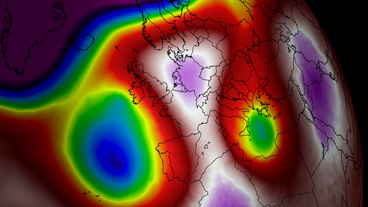
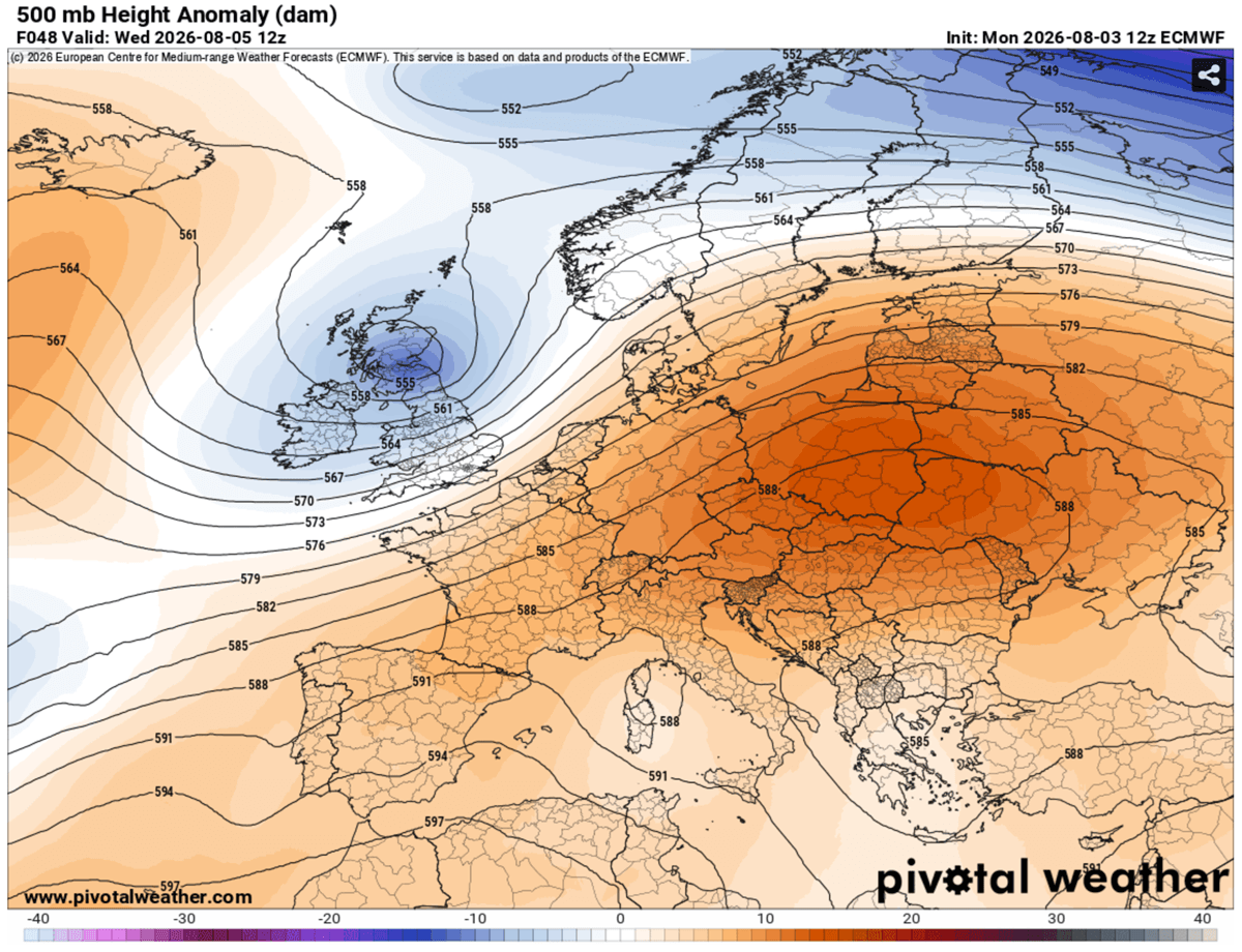
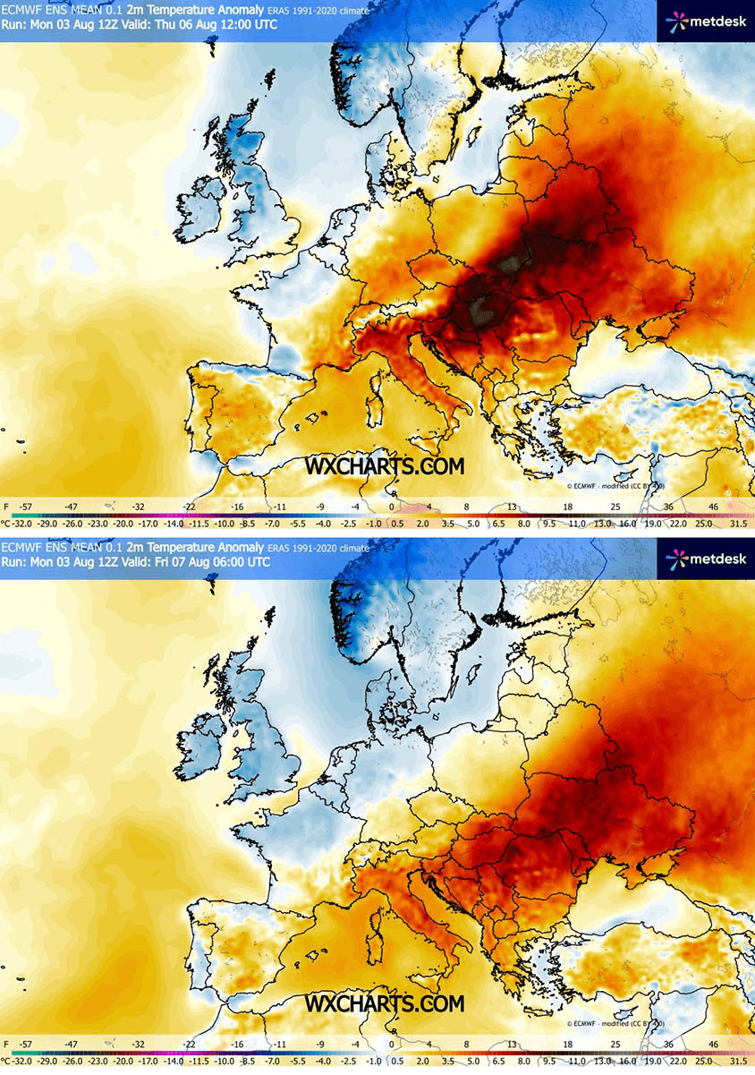
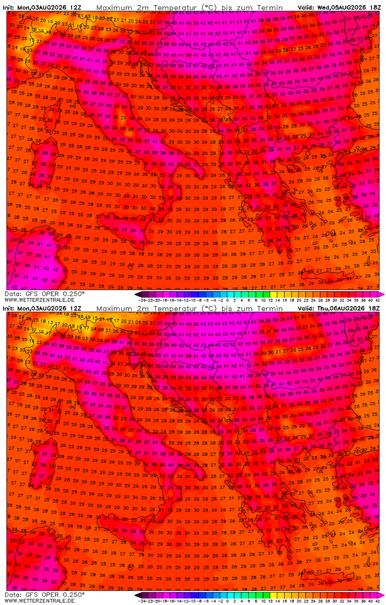
CENTRAL EUROPE — A massive, high-amplitude upper-level ridge is expanding aggressively eastward across Central Europe and the Balkan Peninsula, locking the region into a severe, prolonged heatwave. Daytime highs are surging past 40°C (104°F) and are projected to remain at dangerous levels through the first week of August.
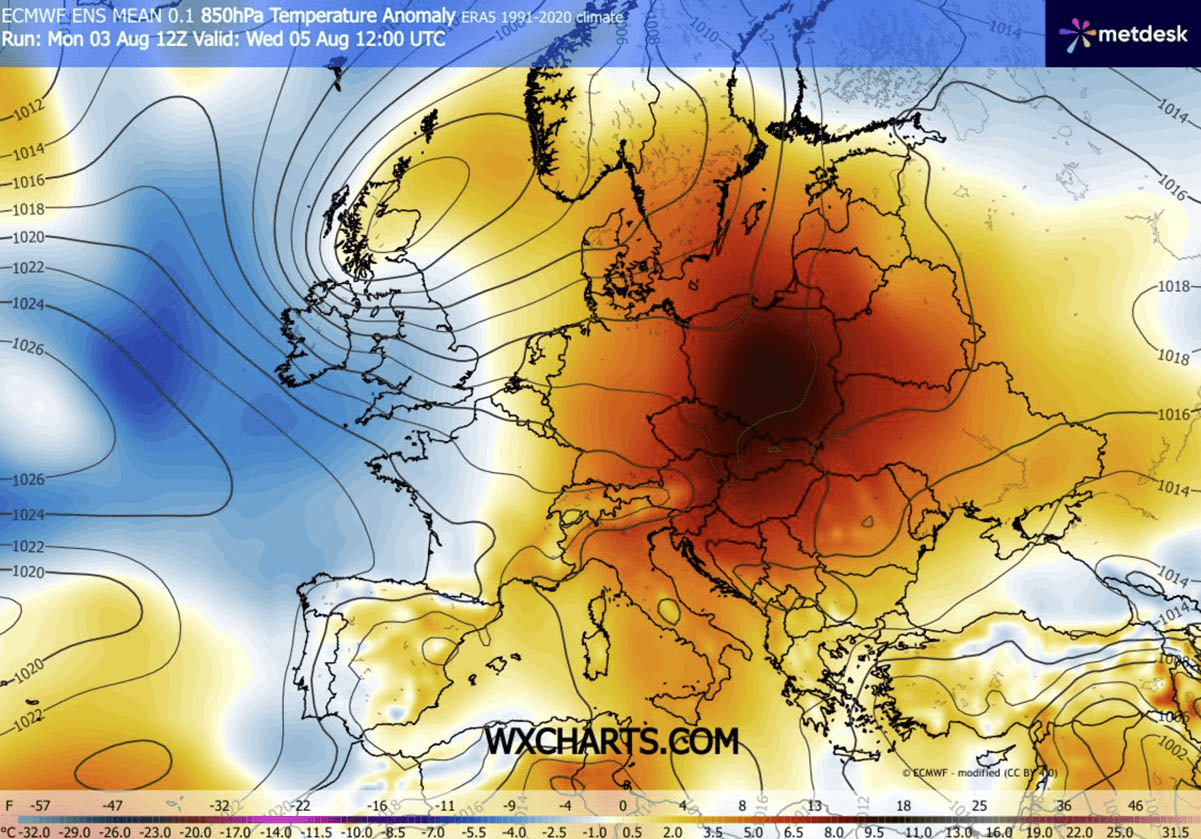
Driven by a stubborn "Heat Dome" synchronized with an Omega block atmospheric pattern, an exceptionally warm and dry air mass continues to surge northward from North Africa. Upper-air thermal anomalies have skyrocketed into the 99th percentile, triggering widespread, excessive heat conditions across northern Italy, Hungary, Croatia, Serbia, and surrounding regions.

The atmospheric engine powering this multi-week thermal event is an unyielding high-pressure system parked directly over the heart of the continent. As descending air compresses and warms the lower troposphere, peak surface temperatures across low-lying river basins—including the fertile Po Valley and the Pannonian Basin—are forecast to peak between 40°C and 43°C (104°F to 109°F). Continental dry winds are simultaneously keeping relative humidity low while dramatically accelerating soil moisture depletion.
Compounding the crisis is a severe lack of nocturnal recovery. Major urban centers are recording "tropical nights," where overnight low temperatures refuse to drop below 22°C to 26°C (72°F to 79°F). This continuous thermal stress poses significant physiological risks to millions of residents, accelerates agricultural drought, and creates explosive wildfire conditions across Southern Europe and the Western Balkans.
Main Facts: Anatomy of a Continental Heat Dome
To understand the severity of the current meteorological event, meteorologists look to the mechanics of the Heat Dome. Similar to historical, record-breaking heatwaves witnessed in North America and Europe, this phenomenon functions as the dominant feature of summer weather patterns.
The Physics of a Heat Dome
An upper-level ridge pattern—frequently referred to as an Upper High or blocking High—forms the core of a heat dome. When a broad, exceptionally stable high-pressure system parks itself over a large portion of a continent for several days or weeks, it acts like a physical lid on a pot.

The extensive dome traps warm air at all levels underneath it, continuously forcing layers of air downward toward the ground (subsidence). As the air sinks, it compresses and heats up significantly, resulting in anomalously warm conditions at low elevations and scorching heat near the surface.
Health Impacts and the Heat Index
The human body relies on cooler nighttime temperatures to recover from daytime heat. The persistence of tropical nights—where temperatures fail to dip below 24°C—denies the body this vital cooling window, compounding physiological stress.
Vulnerable populations are facing the highest risks:
- High-Risk Demographics: The elderly, young children, and individuals with pre-existing cardiovascular or respiratory conditions are exceptionally susceptible to heat exhaustion and heat stroke.
- Outdoor Workers: Construction workers, agricultural laborers, and other outdoor employees face prolonged exposure, drastically increasing their risk of heat-related illnesses, dehydration, and dizziness.
- Urban Heat Islands: Low-income populations living in urban areas are disproportionately affected due to heat-trapping building materials such as concrete, asphalt, and asbestos.
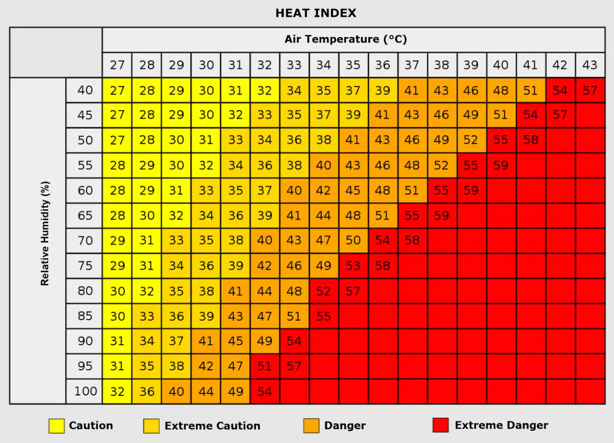
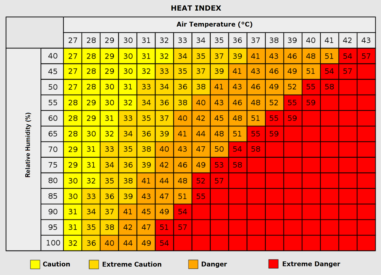
To accurately measure the danger of these conditions, meteorologists utilize the Heat Index, which calculates the combined effect of ambient air temperature and relative humidity. For instance, while an air temperature of 35°C (95°F) paired with low humidity is manageable, the same temperature combined with humidity levels exceeding 80% can push the perceived "feels-like" temperature to a dangerous 50°C (122°F). Medical authorities continue to warn that prolonged heatwaves directly correlate with increased rates of heart attacks, strokes, and acute respiratory distress.
Chronology and Synoptic Setup: The Eastward Migration of the Ridge
The evolution of this weather pattern demonstrates a clear progression across the European continent, shifting from Central Europe toward the east and southeast as the week advances.
Tuesday: Central Europe Peak
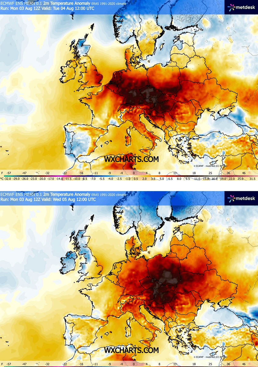
The high-pressure system initially delivered its most intense punch to Germany, eastern Austria, and the Czech Republic. Daytime highs on Tuesday reached 36°C to 38°C in Germany, 37°C to 40°C in the Czech Republic, and up to 40°C across the plains of eastern Austria. Slovakia and Hungary also recorded extreme readings.
Wednesday: Expansion into the Balkans and Italy
By midweek, an upper-level wave emerging into Western Europe began introducing maritime air from the Atlantic, bringing slight refreshment and cooling to the United Kingdom, France, Benelux, and the Iberian Peninsula. However, this same dynamic forced the core of the Heat Dome eastward.
The highest temperature anomalies shifted toward eastern Germany, western Poland, and western Austria. Simultaneously, the Po Valley in northern Italy saw temperatures climb into the low 40s, while readings reached 42°C from Hungary across eastern Croatia and northern Serbia into western Romania.
Thursday and Friday: Peak Intensity in Eastern Europe and the Balkans
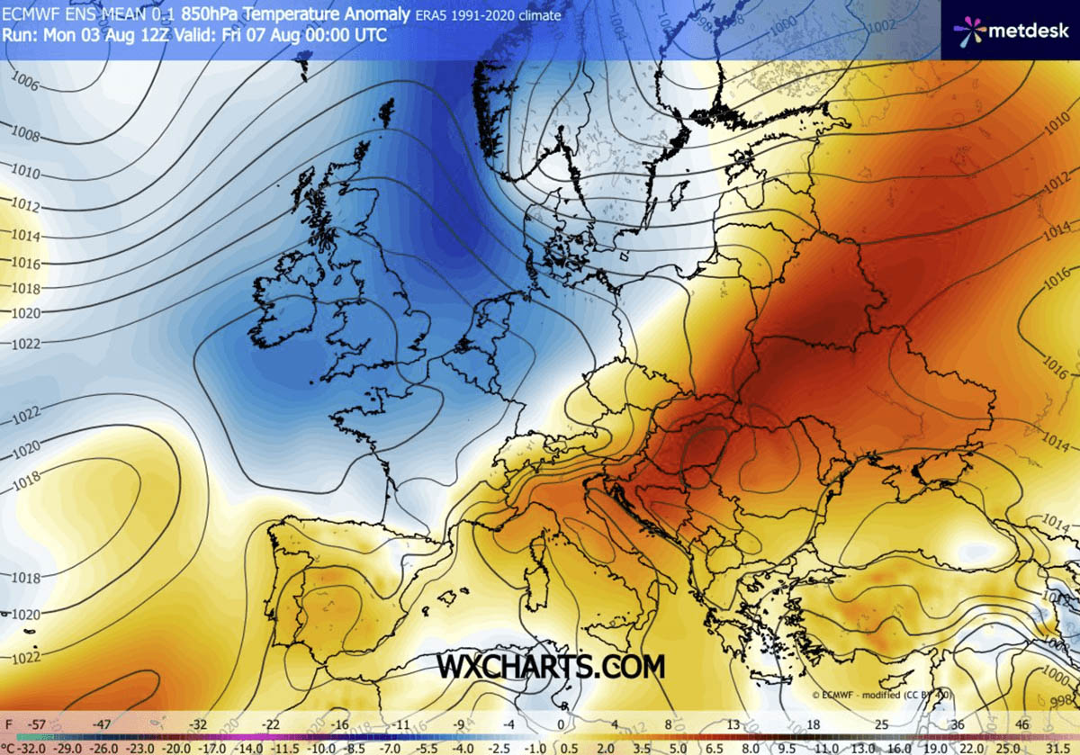
Thursday marked the hottest day of the week for the northern Balkans and Eastern Europe. The heart of the Pannonian Basin recorded blistering peaks of up to 43°C.
As the ridge elongated further southeast into Friday, the extreme heat expanded into western Russia, Bulgaria, and Greece. Valleys throughout Ukraine, eastern Poland, and southern Belarus experienced persistent highs between 38°C and 41°C, accompanied by widespread tropical nights.
Supporting Data: Regional Temperature Breakdowns
Meteorological models and forecasts from resources such as PivotalWeather and WXcharts outline the specific thermal distributions across affected sub-regions:
- Italy and the Balkans: The northern Italian plains and Pannonian plains experienced sustained temperatures above 40°C starting Wednesday, peaking at 43°C by Thursday in the most low-lying basins.
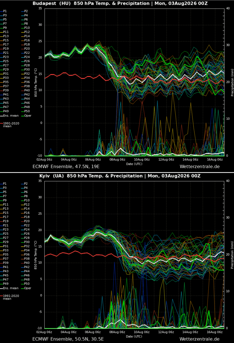
- Central Europe: Germany, the Czech Republic, and eastern Austria experienced their thermal peak early in the week (Tuesday to Wednesday) with upper-level 850 hPa temperature anomalies resting firmly in the 99th percentile.
- Eastern Europe and Ukraine: Late-week conditions brought unprecedented August heat into Ukraine, eastern Poland, and southern Belarus, where daytime highs consistently breached the 40°C threshold alongside low-to-mid-20s overnight lows.
Official Responses and Agricultural/Environmental Implications
As the heatwave tightens its grip, government agencies, civil protection authorities, and agricultural ministries across Central and Eastern Europe have raised alert levels.
Public Safety and Civil Protection
- Red Weather Warnings: National meteorological services in Hungary, Croatia, Serbia, and Romania issued red-level weather alerts—the highest tier—urging citizens to avoid outdoor activities during peak afternoon hours (11:00 AM to 5:00 PM).
- Urban Mitigation: Municipalities in major cities like Budapest, Belgrade, and Zagreb activated emergency protocols, setting up public cooling stations, distributing bottled water in transit hubs, and extending operating hours for air-conditioned public buildings.
- Wildfire Preparedness: Fire services across the Western Balkans and southern Europe have been placed on maximum alert. The combination of triple-digit temperatures, dry continental winds, and severe soil moisture deficits has created explosive conditions for fast-moving wildfires. Authorities have enacted strict outdoor burning bans and increased aerial surveillance in forested regions.
Agricultural and Economic Strain
The agricultural sector is bearing the brunt of the prolonged dry spell. Crop yields for corn, sunflowers, and vineyards in the Pannonian Basin are facing severe stress due to accelerated soil moisture evaporation. Irrigation reservoirs in parts of Romania, Serbia, and Hungary are reporting critically low water levels, prompting local authorities to impose water-use restrictions for non-essential purposes. Energy grids are also experiencing unprecedented peak loads as residential and commercial air conditioning demand surges, though systems have largely held up under the strain thus far.
Future Outlook: A Potential New Heat Dome Next Week?
Even as the current ridge begins to weaken and collapse over Eastern Europe and the Balkans by the upcoming weekend, medium-range weather ensembles indicate that the atmospheric pattern will remain locked in a blocking configuration.
Global weather models show strong agreement that yet another robust upper-level ridge could develop and expand into southwestern, western, and central Europe early next week. While exact positioning remains subject to minor model adjustments nearly ten days out, ensemble forecasts suggest the establishment of a brand-new, persistent Heat Dome.
This developing pattern threatens to trigger a secondary significant heatwave across Portugal, Spain, France, and the Alpine region by mid-August, eventually working its way toward the British Isles.
Meteorologists and climate researchers will continue to monitor the evolution of these synoptic patterns, providing updated forecasts as the atmospheric situation develops. Residents in previously impacted and newly threatened regions are advised to stay tuned to local meteorological advisories and follow civil protection guidelines closely.
