

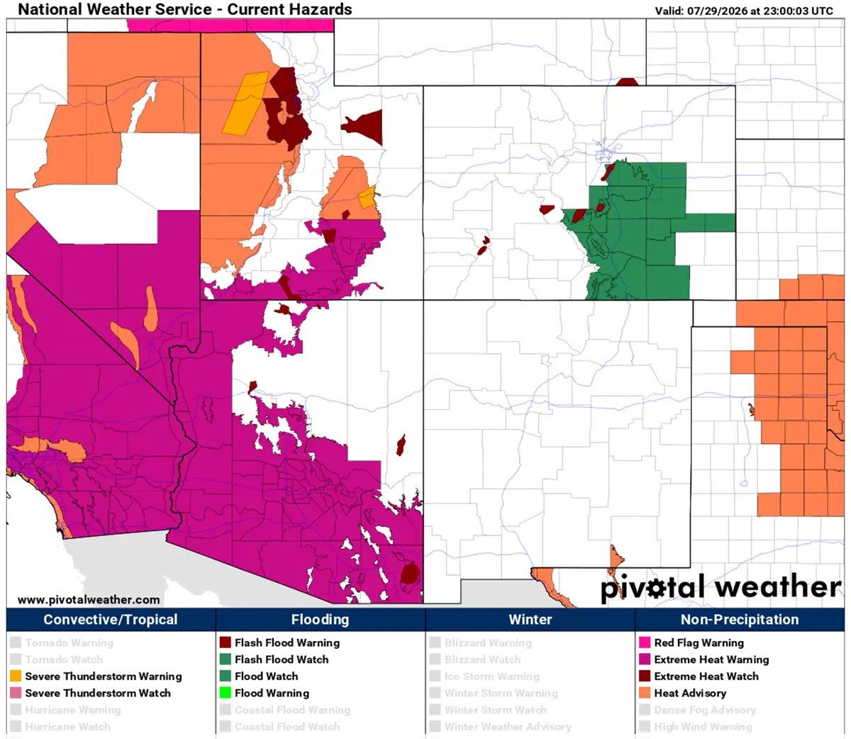
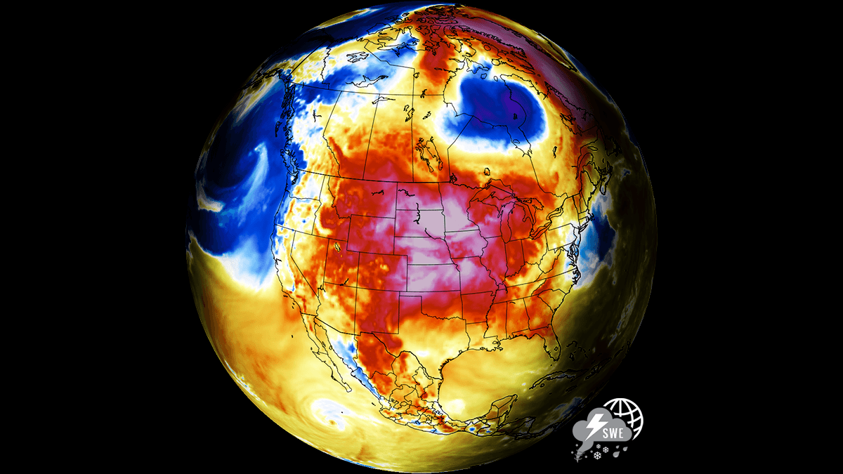
WASHINGTON — A formidable high-amplitude upper-level ridge has locked a massive and persistent "Heat Dome" across the North American continent, driving peak afternoon temperatures past 105°F to 110°F across the American Southwest, the central plains, and parts of Canada heading into early August.
Supported by deep atmospheric compression, this stationary warm plume is sending upper-air thermal anomalies soaring into the 99th percentile. The resulting excessive heat warnings stretch dangerously from Southern California across the Great Plains and up into the Mississippi Valley, creating a multi-week meteorological crisis that is taxing regional power grids, accelerating agricultural drought, and posing acute public health risks.
Main Facts: Anatomy of a Continental Heat Dome
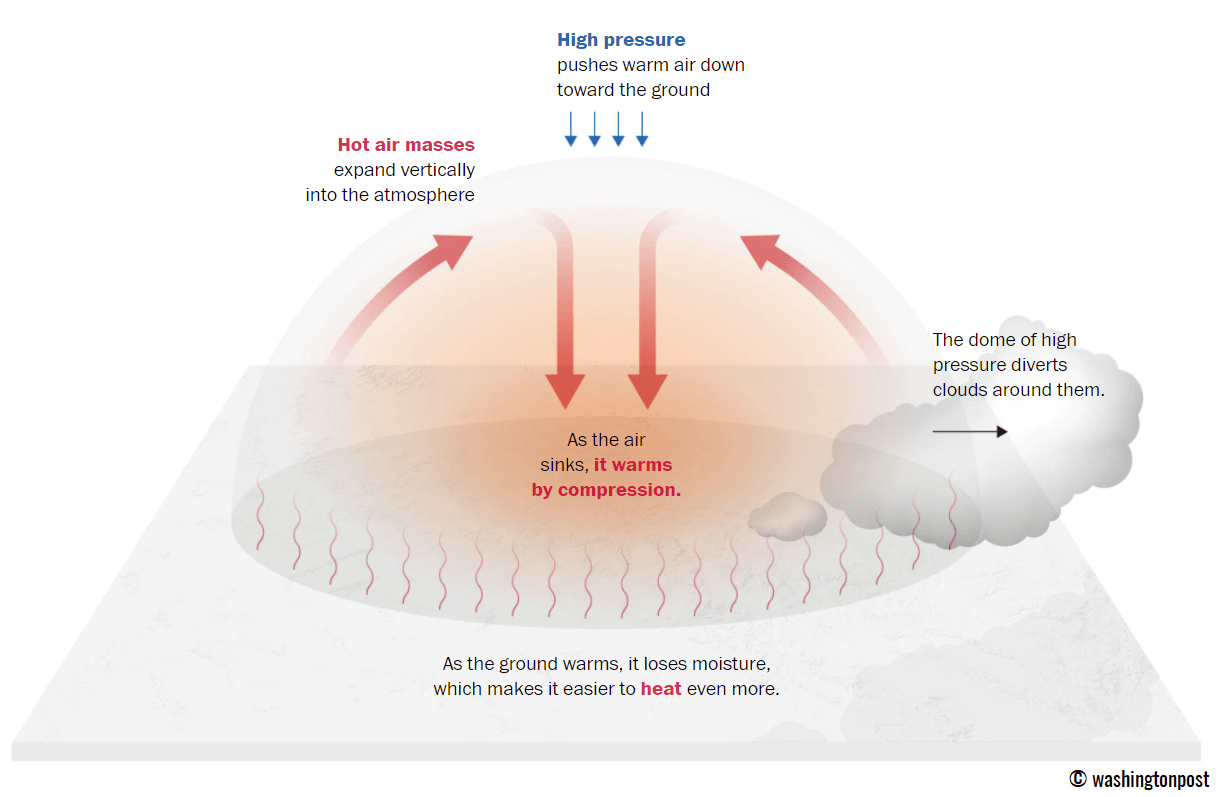
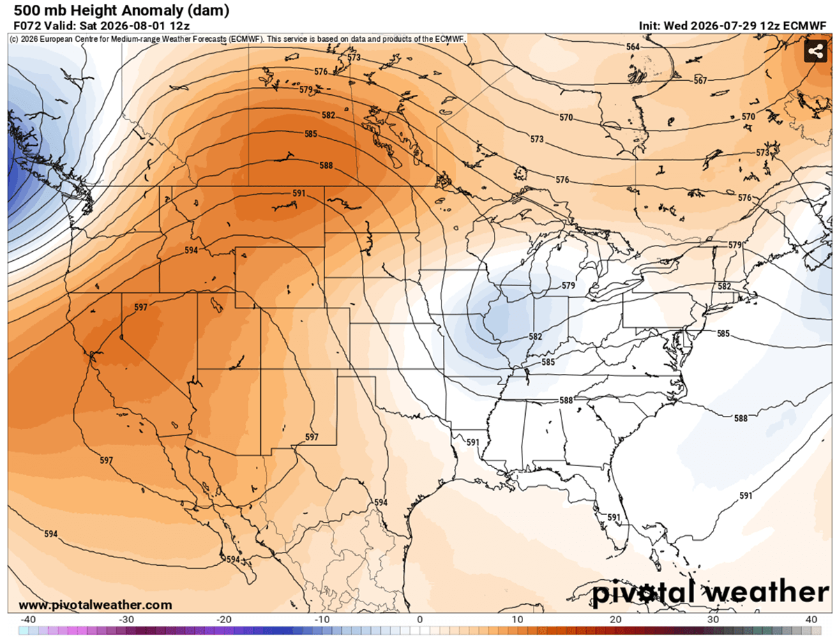
The core driver of this prolonged weather event is a dominant high-pressure system trapped over the western and central United States and parts of western Canada. Meteorologists characterize this structural phenomenon as a "heat dome," which functions fundamentally like a lid on a pot.
The Atmospheric Mechanism
An upper-level ridge—or a blocking high-pressure system in the upper atmosphere—pushes warm air downward through deep atmospheric compression. As the air masses sink toward the lower elevations, they compress and rapidly heat up. This continuous, sinking motion prevents cooler surface air from rising and stops cloud formation, allowing uninterrupted solar radiation to bake the landscape day after day.
Geographic Reach and Intensification
- The Desert Basins: The most extreme thermal impacts are concentrated in the desert Southwest and interior California, where peak afternoon highs are soaring between 115°F and 120°F.
- Urban Corridors: Major metropolitan areas are experiencing little to no relief overnight, with nocturnal low temperatures struggling to drop below 75°F to 80°F.
- The Northern Expansion: The blocking ridge has expanded northward into the Canadian provinces of Alberta and Saskatchewan, bringing unprecedented multi-day heat anomalies to regions unaccustomed to such prolonged thermal stress.
Chronology: The Multi-Week Progression of the Heatwave
The current meteorological setup has evolved in distinct phases, shifting from a regional warm-up into a continental-scale heat emergency.
Mid-Week Buildup (Thursday – Friday)
As the upper-level ridge anchored itself firmly over the Western U.S. and the Northern Rockies, surface temperatures began a steady climb. Readings across the Great Plains pushed into the upper 90s and hovered near 103°F. Meanwhile, a shallow low-pressure system drifted east from the mid-Mississippi Valley toward the Southeast U.S., but it failed to disrupt the dominant western ridge, allowing the heat dome to strengthen its grip.
Weekend Peak (Saturday – Sunday)
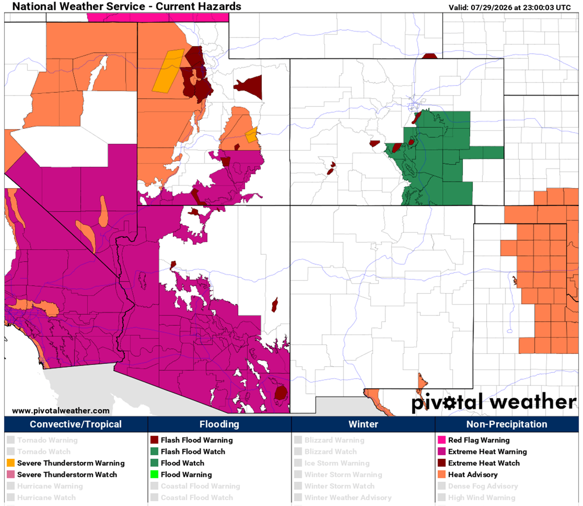
The heat dome reached maximum atmospheric intensity over the weekend. On Saturday, air masses over Montana, Wyoming, and the western Dakotas baked under the peak of the dome, driving afternoon highs from 103°F to nearly 110°F. Simultaneously, daytime highs across Arizona, Nevada, and California remained locked between 115°F and 120°F.
By Sunday, the thermal peak expanded eastward, encompassing the central and southern Plains from Texas to the Dakotas, maintaining relentless triple-digit readings.
Early Week Transition (Monday and Beyond)
Heading into early August, the axis of the hottest air mass is shifting slightly toward the central and southern Plains, maintaining daily peaks of 100°F to 105°F across New Mexico, Texas, and the Colorado High Plains. However, global weather models indicate a forthcoming pattern shift: an incoming frontal system moving east out of Canada is projected to introduce cooler air, gradually lowering temperatures across the northern High Plains by Wednesday.
Supporting Data: Temperature Anomalies and Heat Indices
The severity of this event is underscored by extreme anomalies in atmospheric pressure levels and humidity-adjusted "feels-like" temperatures.
850 hPa Thermal Anomalies
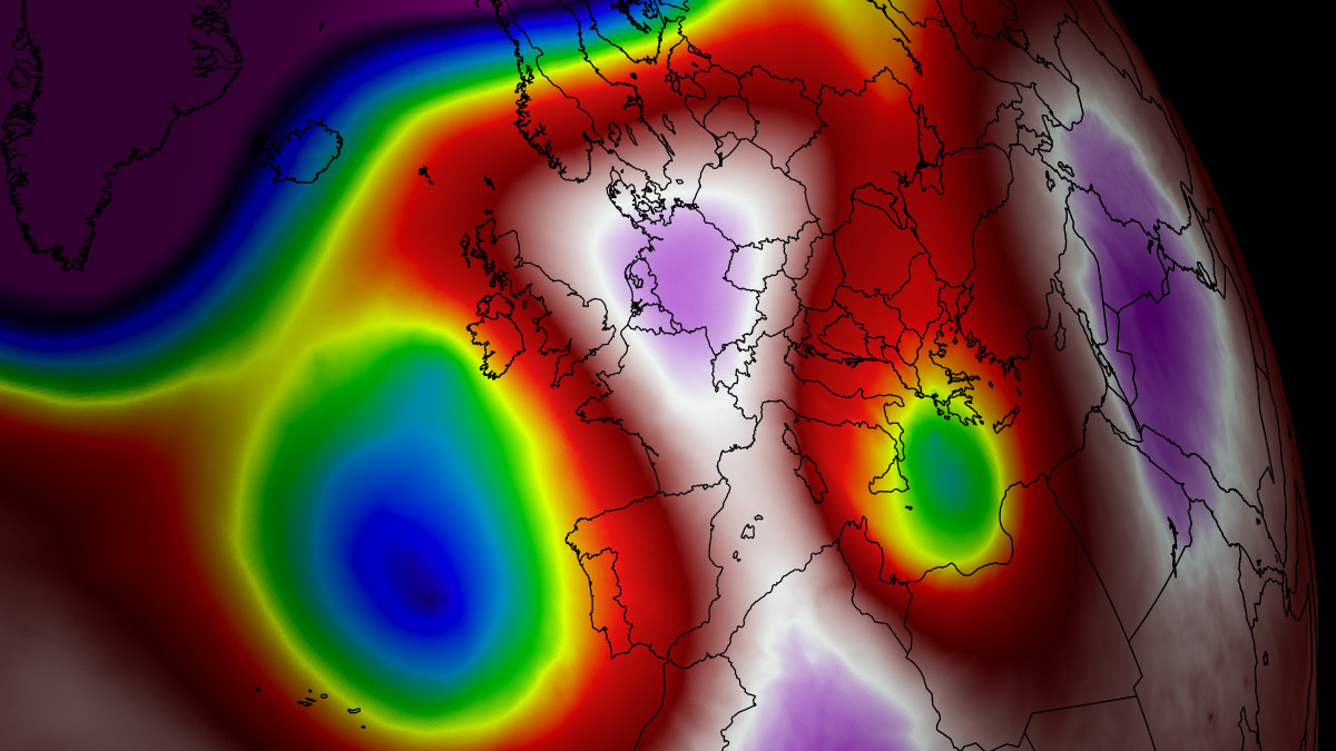
Meteorologists track these events using 850 hPa (hectopascal) temperature maps—roughly 5,000 feet above sea level—to measure the raw heat of the air mass before surface-level variables interfere. Current charts show anomalies sitting firmly in the 99th percentile for early August. This massive reservoir of heat aloft guarantees that any mixing of air will only reinforce the scorching conditions at the surface.
The Danger of the Heat Index
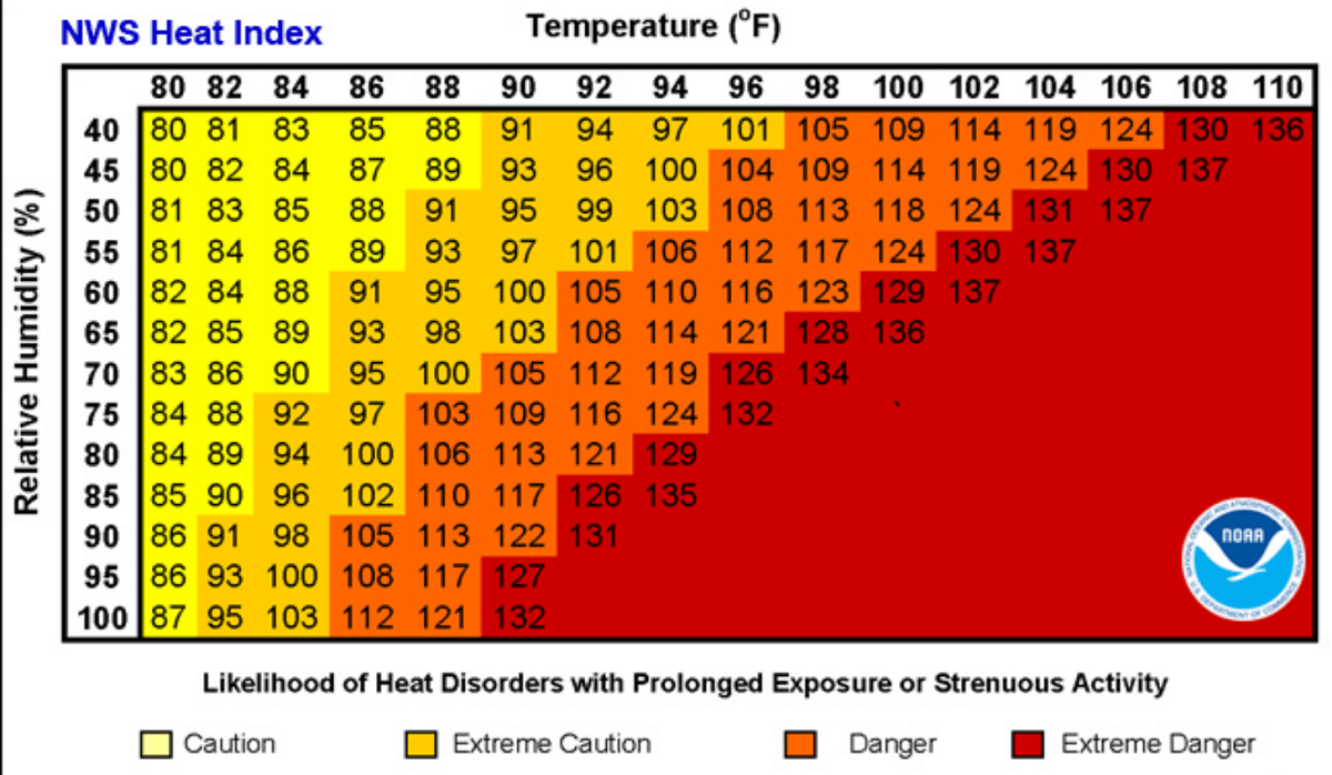
High relative humidity combined with soaring ambient temperatures has pushed the Heat Index to dangerous thresholds. Meteorologists emphasize that humidity fundamentally alters how the human body cools itself through perspiration.
- The Humidity Factor: When ambient air temperature is 90°F with low humidity (below 60%), the human body can manage thermoregulation relatively well.
- The Scalding Threshold: When humidity climbs above 80% at that same 90°F baseline, the apparent "feels-like" temperature skyrockets to approximately 113°F.
Under these conditions, simple outdoor exertion becomes rapidly hazardous as the body’s cooling mechanisms fail to keep pace with environmental heat gain.
Official Responses and Public Health Implications
Public health officials, emergency management agencies, and grid operators have mobilized emergency protocols across multiple states to mitigate loss of life and prevent cascading infrastructure failures.
Public Health Advisories and Vulnerable Populations
Health authorities have issued widespread excessive heat warnings, urging residents to limit outdoor activities during peak afternoon hours. Medical professionals stress that prolonged exposure to extreme heat triggers a spectrum of cascading health crises:
- Heat Exhaustion and Stroke: Continuous exposure leads rapidly to severe dehydration, dizziness, confusion, and ultimately heatstroke—a medical emergency with a high mortality rate if untreated.
- Cardiovascular and Respiratory Strain: Heatwaves are statistically correlated with a surge in heart attacks, strokes, and acute respiratory illnesses, particularly among the elderly.
- Socioeconomic Disparities: Urban populations living in lower-income neighborhoods face disproportionate risks. These communities often feature "urban heat island" effects, characterized by dense concentration of heat-absorbing surfaces like concrete and asphalt, coupled with inadequate residential air conditioning.
- Outdoor Workers: Agricultural laborers, construction crews, and delivery personnel face heightened occupational hazards, prompting mandatory hydration breaks and adjusted shift hours in several jurisdictions.
Power Grid Stress and Energy Management
The lack of nocturnal cooling—where temperatures fail to drop below 75°F to 80°F at night—prevents homes and bodies from recovering from daytime heat stress. Consequently, residential and commercial air conditioning demand has spiked to near-record levels. Grid operators across the Southwest and central plains have requested voluntary energy conservation during peak evening hours to prevent rolling blackouts and protect electrical infrastructure from thermal overload.
Broader Implications: Agriculture and Climate Context
Beyond immediate human health and energy concerns, the multi-week duration of this heat dome carries severe secondary implications for regional ecosystems and food production.
Agricultural Drought and Soil Moisture Depletion
The persistent high-pressure dome is rapidly accelerating soil moisture depletion across the primary agricultural belts of the Great Plains and the Midwest. Evapotranspiration rates—the sum of evaporation and plant transpiration—are exceptionally high, placing immense stress on rain-fed crops during critical stages of their summer growing cycle. Without substantial precipitation relief, prolonged soil desiccation threatens agricultural yields.
The Macro Climate Picture
This event unfolds against a backdrop of shifting global weather patterns, including the emergence of a strong El Niño phase influencing atmospheric circulation across North America. Climatologists note that while natural ridging patterns frequently create summer heatwaves, the intensity, spatial extent, and duration of modern heat domes are increasingly exacerbated by background planetary warming.
As forecasters continue to track the impending Canadian cold front that promises temporary relief to the northern tier next week, emergency management agencies urge the public to remain vigilant, utilize designated cooling centers, and monitor official weather updates as the August heatwave persists.
