

As the meteorological community turns its eyes toward the upcoming colder months, atmospheric and oceanic indicators are pointing toward a winter season unlike any seen in modern meteorological record-keeping. Propelled by a historic Pacific basin warming event, the Winter 2026/2027 outlook has shifted decisively.
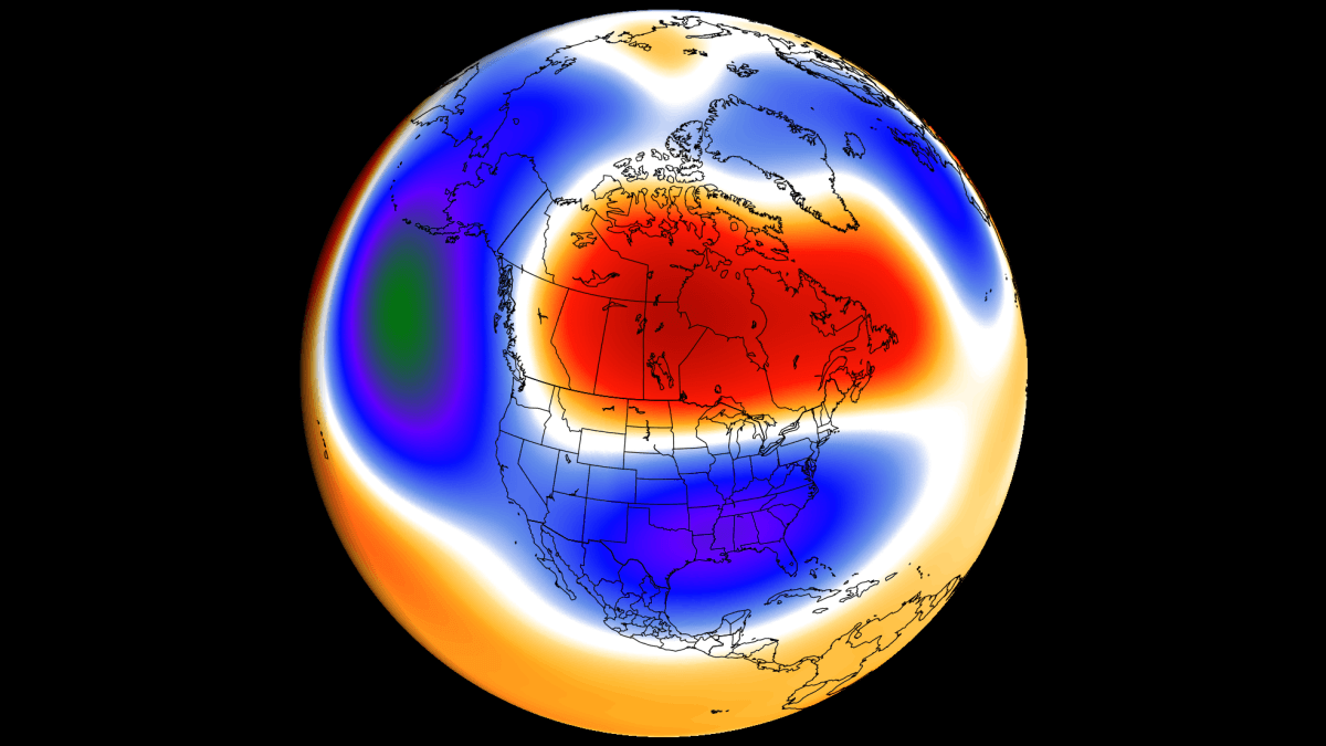
While conventional wisdom often associates El Niño phases with universally mild winter conditions, recent multi-model forecast data—spearheaded by the latest European Centre for Medium-Range Weather Forecasts (ECMWF) runs—reveals a far more complex, high-impact scenario. This unfolding Super El Niño is on a trajectory to break 75-year intensity records, setting the stage for a dramatically amplified winter pattern characterized by severe weather contrasts across North America and Europe.
Main Facts: A Record-Breaking Pacific Driver
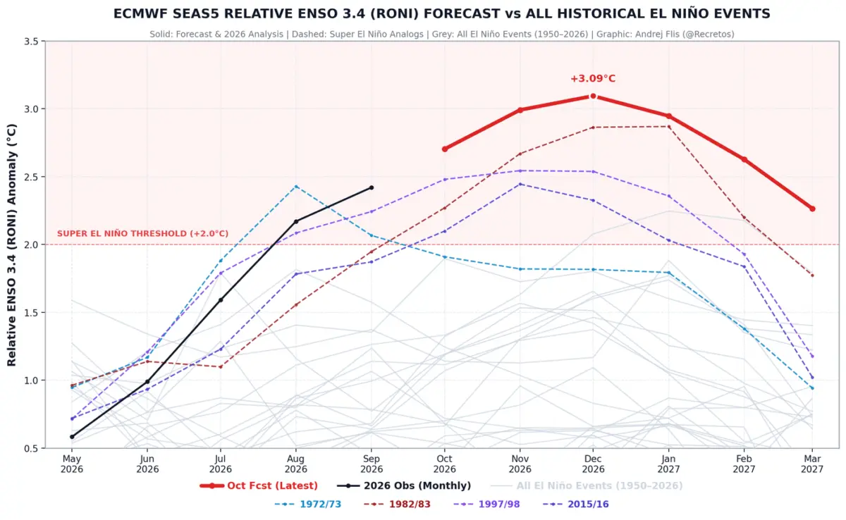
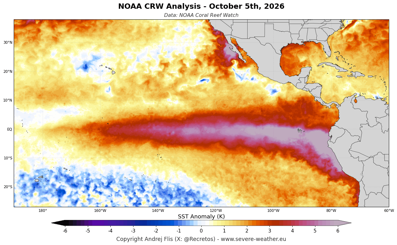
The core engine driving the Winter 2026/2027 atmospheric pattern is a rapidly developing Super El Niño. According to recent analysis utilizing NOAA Coral Reef Watch (CRW) and Copernicus ERA5 data, sea surface temperatures across the equatorial ENSO region have surged to anomalies well over 6°C (11°F) above normal in the eastern Pacific.
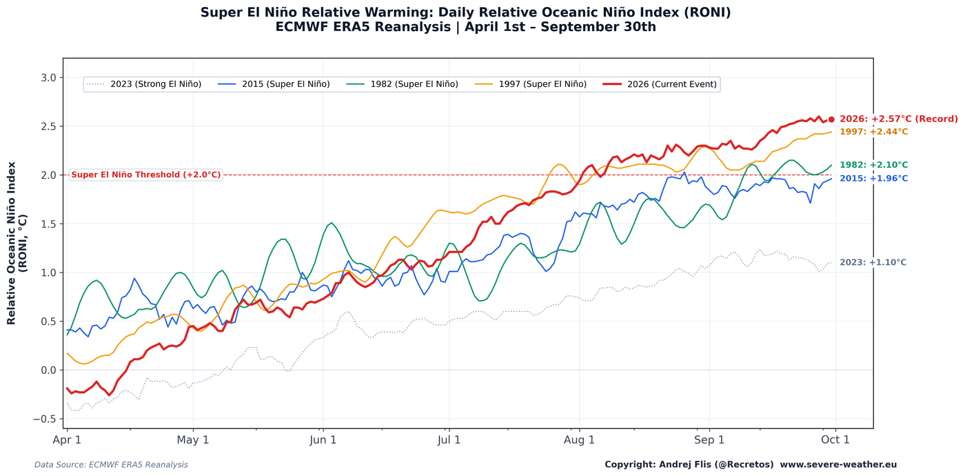
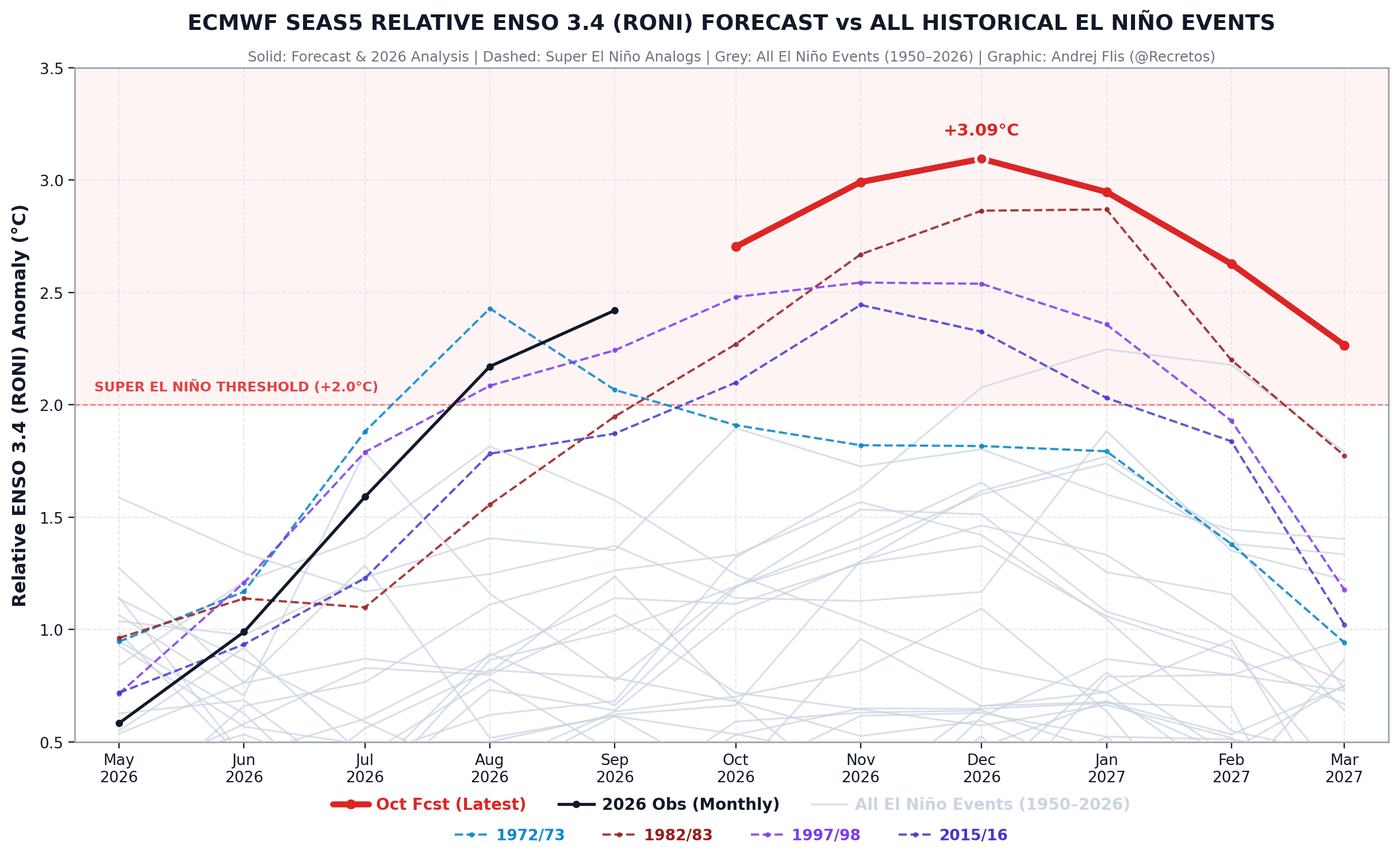
Comparing this season’s growth curve to historical analogs reveals that the 2026/2027 event is running ahead of every major Super El Niño recorded over the past seven decades, easily surpassing benchmarks set in 1972/1973, 1982/1983, 1997/1998, and 2015/2016.
- Intensity: Projected to peak around December as the strongest El Niño event since at least 1950.
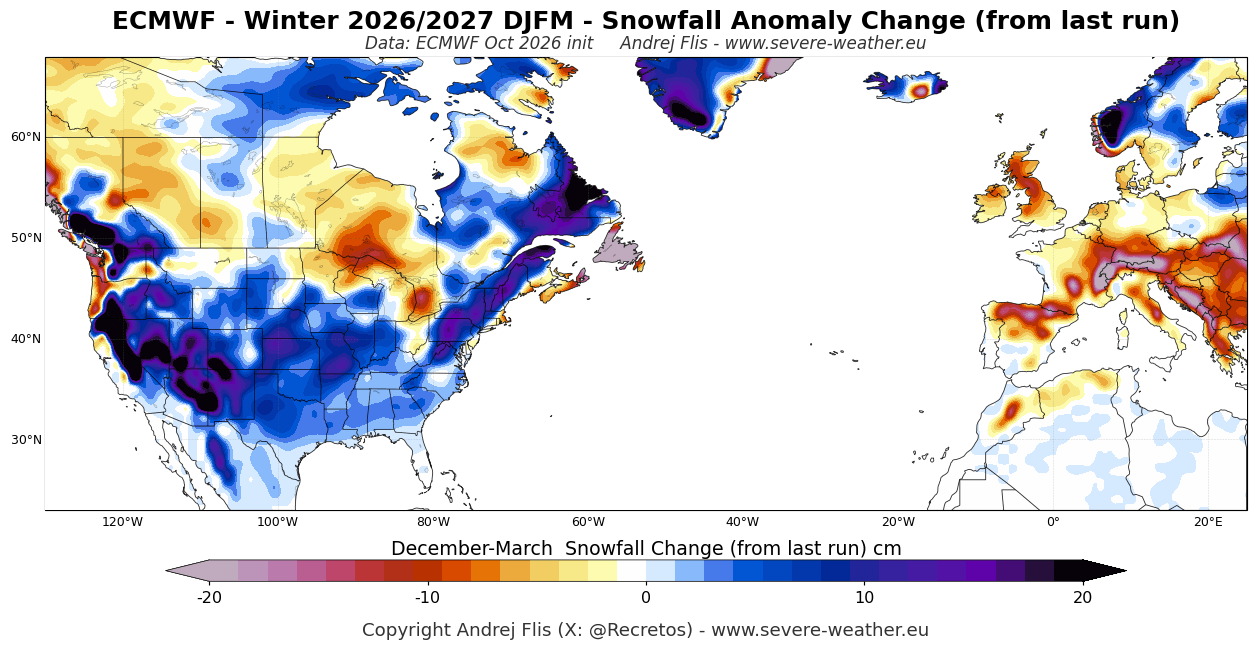
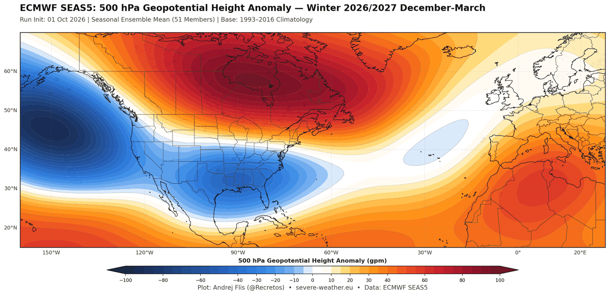
- North American Impact: A stark divide is forming. Northern U.S. states and southern Canada face a mild, high-pressure-dominated regime, whereas the southern, central, and eastern United States face an active, stormy southern jet stream with colder-than-normal temperature trends and heightened snowfall potential.
- European Impact: Dominated by a robust, mild westerly and southwesterly flow from the Atlantic, leading to above-average temperatures and ample precipitation, though largely devoid of widespread lowland snowfall.
- The Polar Vortex Factor: Forecast models indicate an unusual stratospheric slowdown and potential disruption by mid-winter, raising the probability of a "backloaded" winter with intense cold outbreaks late in the season.
Chronology of the Forecast: Evolution of the October Data
To understand how the Winter 2026/2027 outlook has matured, meteorologists monitor the incremental shifts between successive long-range model runs. The October 2026 forecast data introduced significant revisions to the seasonal baseline.
Early Spring to October: The Ascent to "Super" Status
The anomalous warming in the Pacific manifested rapidly during the spring of 2026. By early autumn, global sea surface temperature tracking confirmed that the event had transitioned into rare "Super" territory. The World Meteorological Organization (WMO) subsequently verified a near-100% statistical certainty that the event would sustain its peak intensity through the entirety of the meteorological winter.
The October ECMWF Trend Shift
When comparing the latest ECMWF seasonal model run to its predecessor, distinct pattern amplifications emerge:
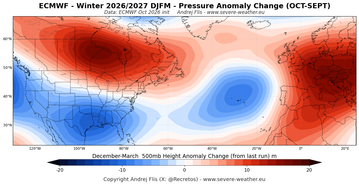
- Pressure Anomalies: The low-pressure zone over the United States and the blocking high-pressure zone over Canada have both intensified significantly.
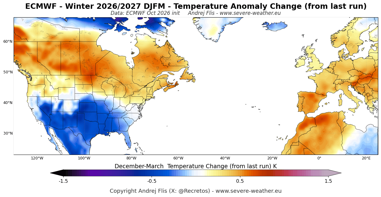
- Temperature Revisions: The latest output trends noticeably colder for the southern half of the United States, diverging from earlier, more uniformly mild projections. Conversely, Europe’s temperature projections warmed further, reflecting an entrenched high-pressure signature over the continent.
- Snowfall Enhancements: The updated data shows an expansion of above-normal snowfall potential across major portions of the central, western, and eastern United States, even as the upper Midwest and southern Canada trend drier.
Supporting Data: Lessons from Past Super El Niños
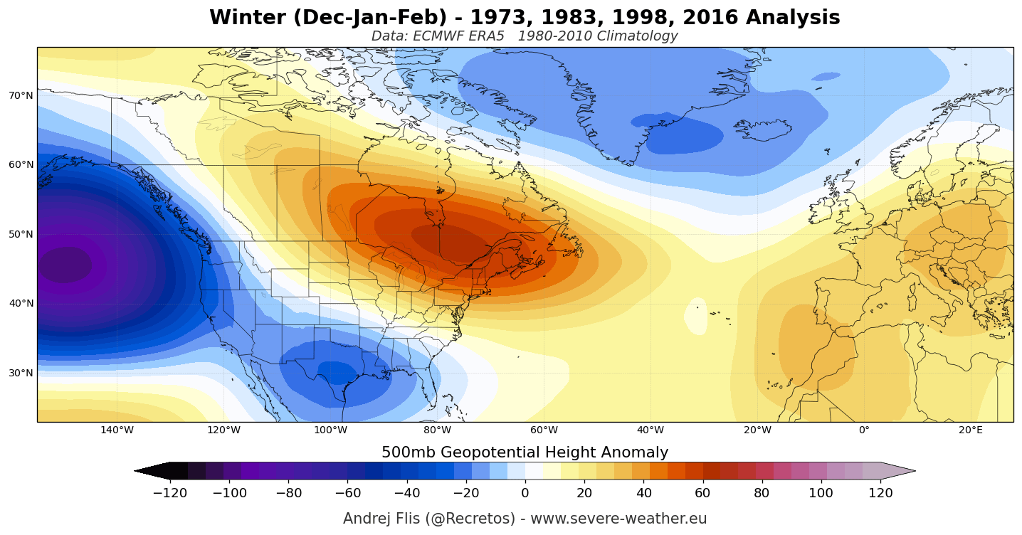
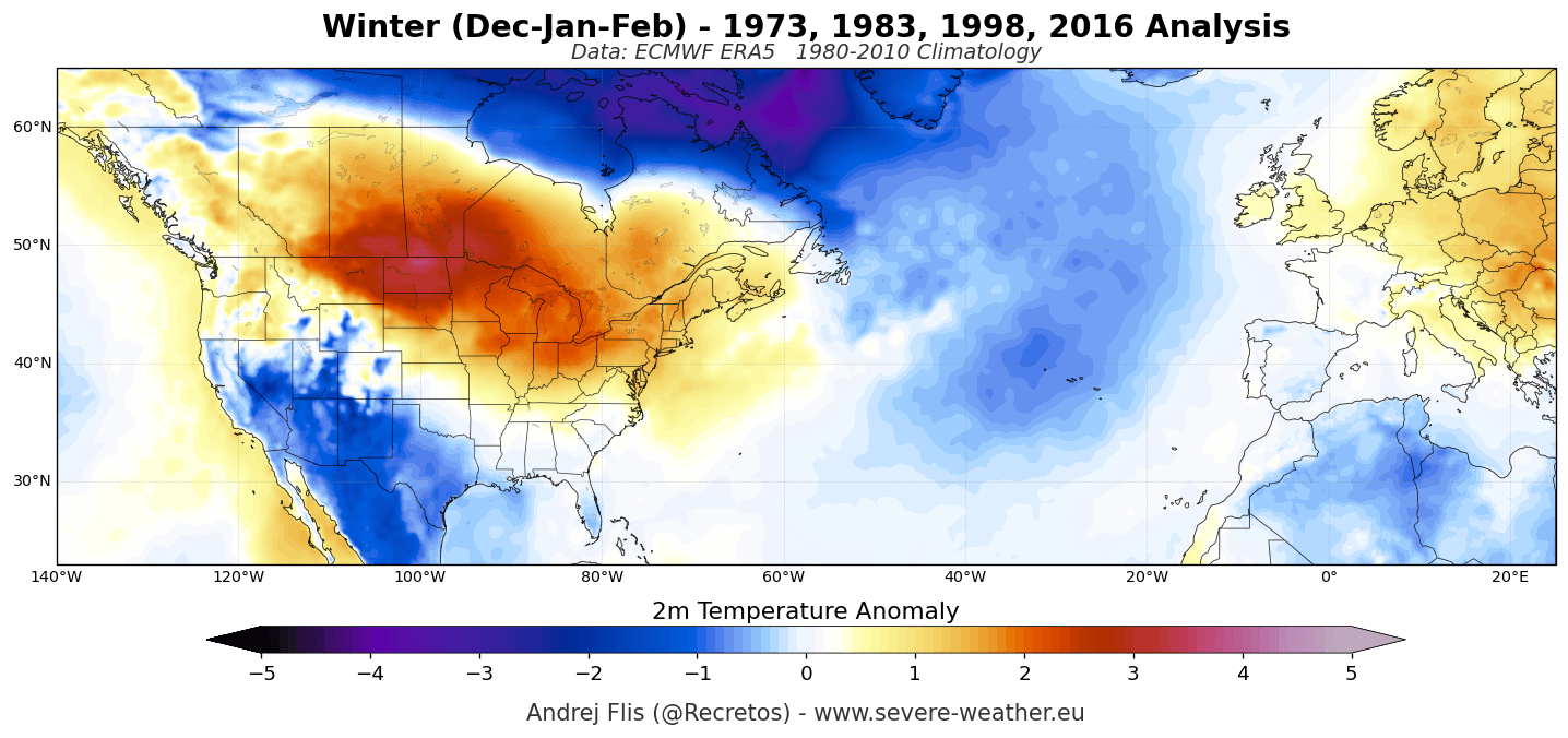
To contextualize what a record-strong El Niño can deliver at the surface, climatologists look back at historic winters that bore the exact same atmospheric fingerprint: a deep Aleutian Low in the North Pacific paired with a massive blocking ridge over Canada and the northern U.S.
Historical Winter Storm Signatures
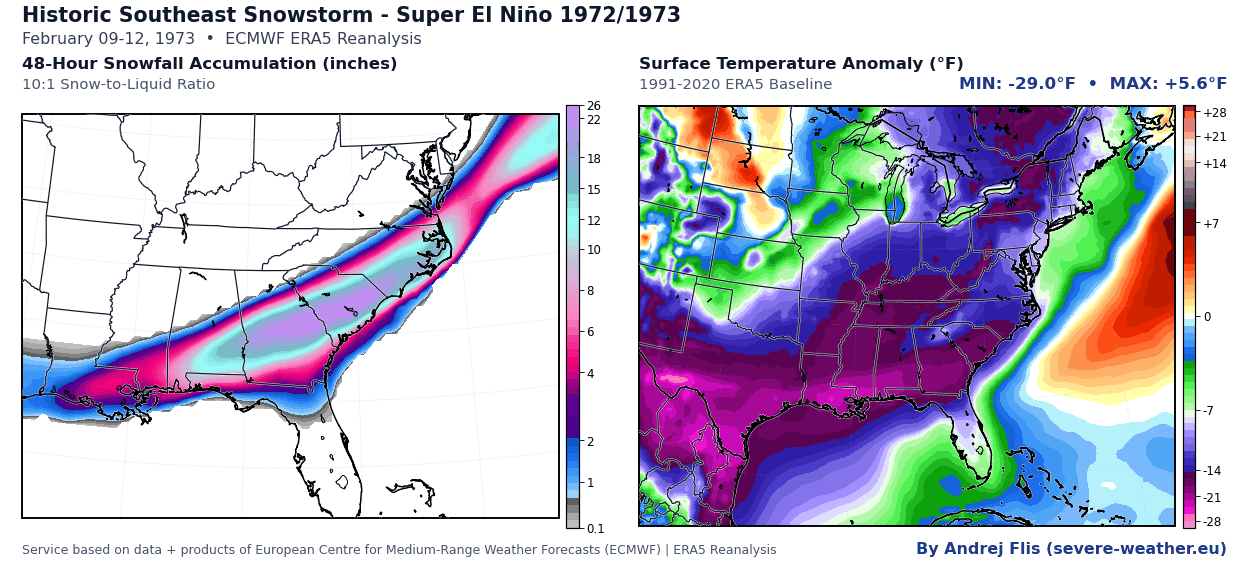
- The Great Southeastern Snowstorm (1972/1973): In February 1973, a strengthening Gulf low pressure system buried parts of the Southeast. Rimini, South Carolina, recorded an astonishing 24 inches of snow, with accumulating snow reaching as far south as coastal Georgia and Tallahassee, Florida.
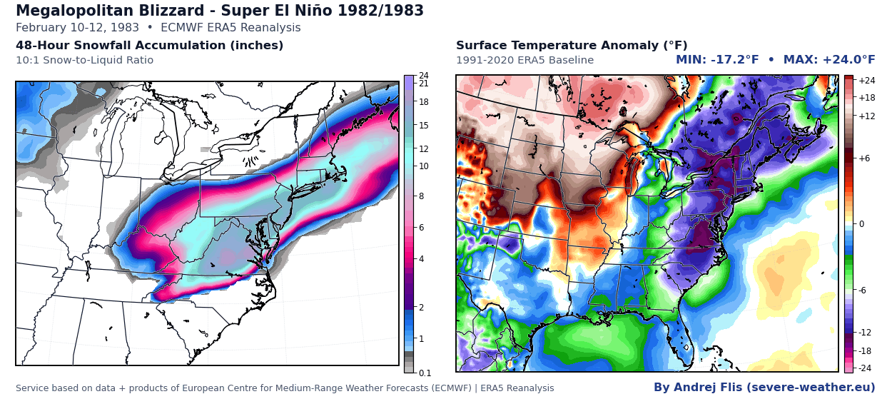
- The Megalopolitan Blizzard (1982/1983): In February 1983, a classic, powerful Nor’easter dropped snowfall rates of 2 to 5 inches per hour along the I-95 corridor. Baltimore and Philadelphia shattered their 24-hour snowfall records, paralyzing the major metropolitan areas from Washington, D.C., to Boston.
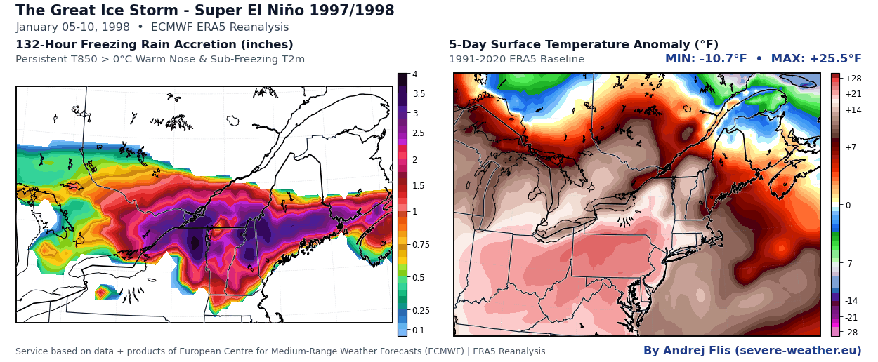
- The Great Ice Storm (1997/1998): January 1998 brought a devastating ice accretion event to northern New York, northern New England, and southeastern Canada. Widespread power outages lasted up to three weeks, triggering federal disaster declarations across multiple states.
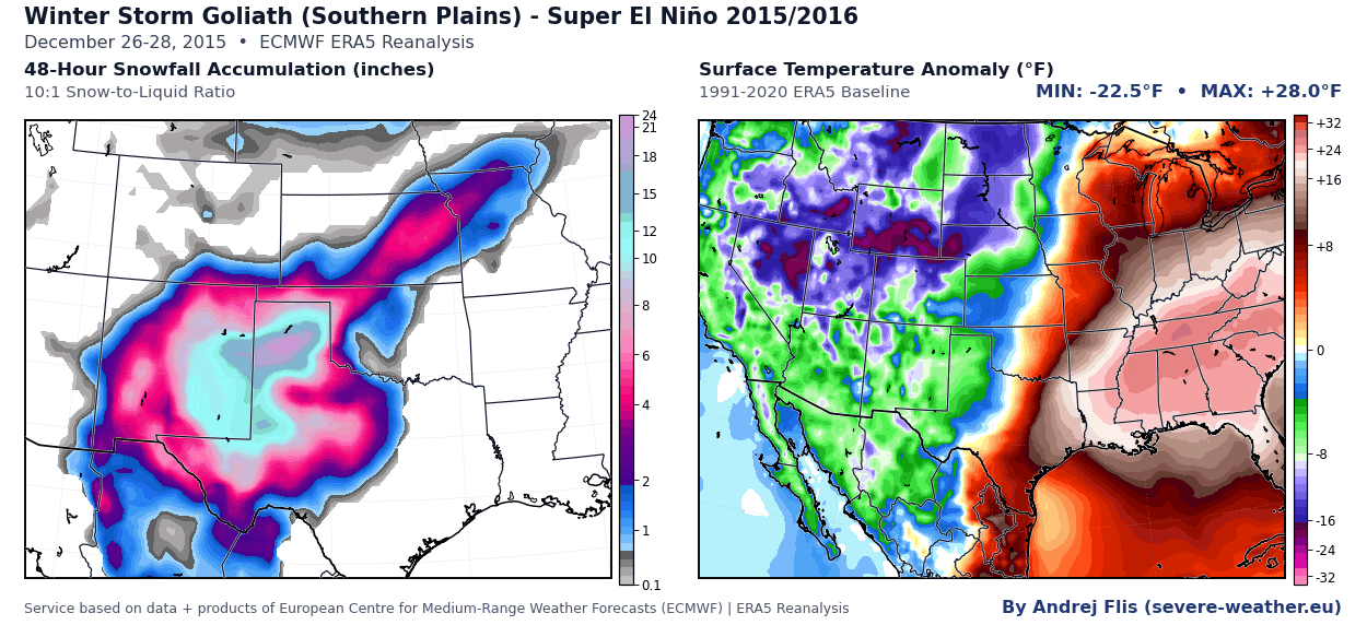
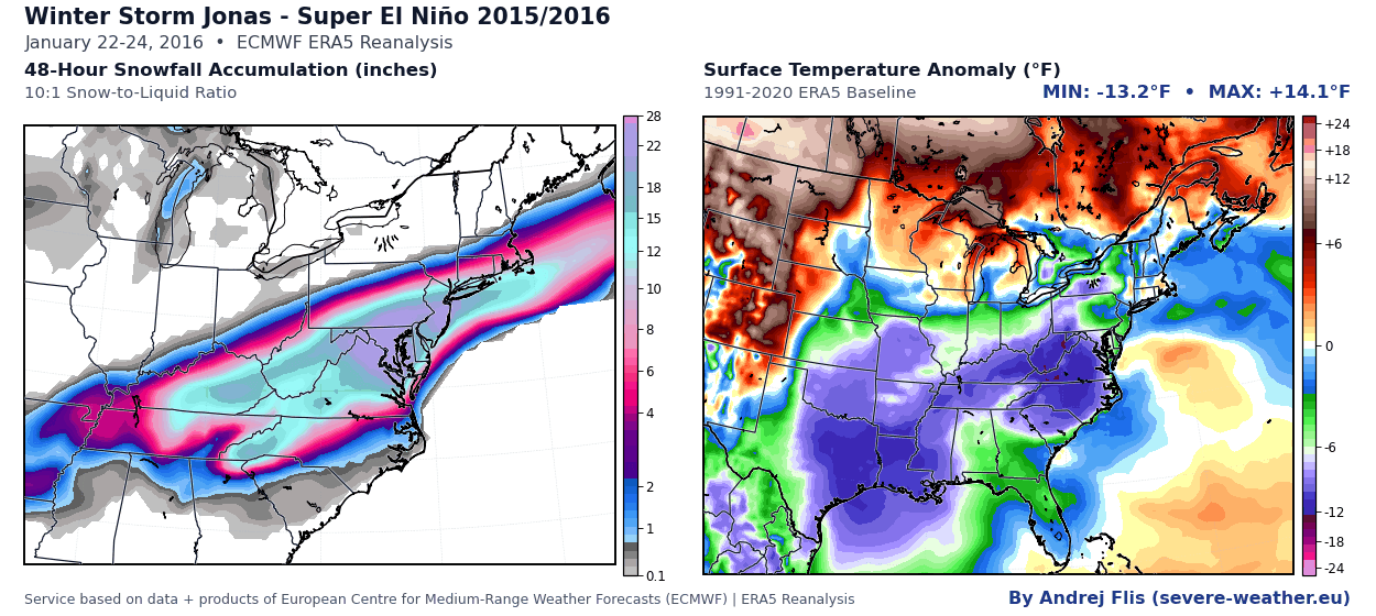
- The Christmas Weekend Blizzard & Historic Nor’easter (2015/2016): The last major Super El Niño delivered a dual-punch. First, a severe Christmas blizzard struck the Southern Plains, dropping 2 to 3 feet of snow in New Mexico and Texas. Weeks later, in January 2016, a Category 4 Nor’easter paralyzed the East Coast, dumping over 27 inches in New York City and 29 inches in Baltimore, impacting over 100 million people.
These historical precedents demonstrate that while El Niño generally tilts the statistical odds toward warmth, its energetic jet stream serves as a conveyor belt for moisture that can collide with sudden cold air outbreaks to produce historic winter storms.
Official Responses and Global Guidance
International meteorological bodies have issued consistent warnings regarding the cascading impacts of the 2026/2027 Super El Niño.
The World Meteorological Organization has emphasized that extreme strength in ENSO cycles disproportionately increases the risk of compound weather extremes worldwide. While the direct thermodynamic impacts are most pronounced across the Americas, global teleconnections are expected to disrupt standard precipitation cycles, increasing flood risks in the southern tier of the U.S. and parts of southern Europe, while threatening drought conditions in the Pacific Northwest and sections of the Upper Midwest.
National weather agencies, including NOAA and Environment and Climate Change Canada, are coordinating regional preparedness strategies. Their focus centers on the heightened threat of heavy wet snow accumulation, ice storms along transitional temperature zones, and rapid hydrological shifts as heavy precipitation falls on saturated or frozen ground.
Implications for Winter 2026/2027: Regional Breakdowns
As the season approaches, distinct geographic zones face sharply contrasting outlooks based on the latest model guidance:
1. United States and Canada
- The North: Southern Canada, the Pacific Northwest, and the northern tier of the U.S. will experience a predominantly mild winter under the influence of Canadian high-pressure ridging, resulting in below-normal seasonal snowfall.
- The South, Center, and East: An active southern jet stream will drive above-normal precipitation. Supported by colder October data trends, the Central Plains, Ohio Valley, Southern Appalachians, and the interior Mid-Atlantic are at a heightened risk for significant winter storms, accumulating ice, and disruptive snow events.
- The Mountain West & Ski Resorts: The strongest seasonal snowfall signal is locked over the Sierra Nevada in California. Above-normal snowpacks are also favored across the Great Basin, Utah, the Southern Rockies, and the high elevations of Arizona and New Mexico.
2. Europe
- Continental Patterns: Europe will largely experience a mild, wet westerly and southwesterly flow from the Atlantic. Seasonal temperature anomalies point to an overwhelmingly above-average warmth profile across central and southern areas.
- Snowfall Outlook: Lowland snow chances remain low. Ski resorts across the Alps and lower elevations face a challenging snowpack season, with natural accumulation largely restricted to the highest elevations (above 1,800 to 2,000 meters) and northern European sectors where occasional northerly dips manage to penetrate.
3. The Mid-Winter Wildcard: The Polar Vortex
Perhaps the most critical implication for the second half of winter is the behavior of the stratospheric Polar Vortex. ECMWF diagnostic data indicates an unusual weakening of stratospheric zonal winds starting in late December and extending deep into January 2027.
When combined with historical research showing that strong El Niños send upward atmospheric wave energy that stresses the vortex, numerical models from NOAA (CFSv2) and Canada (CanSIPS) suggest a major pattern amplification by February. If this stratospheric slowdown transitions into a Sudden Stratospheric Warming (SSW) event, the door could open for a classic "Polar Express" pattern—ushering in severe, late-season cold air outbreaks across the central, southern, and eastern United States.
Summary
The Winter 2026/2027 season will not be a monolithic block of mild weather. Driven by a record-shattering Super El Niño and a volatile stratospheric setup, the upcoming winter promises a tale of two extremes: tranquil warmth across the northern tier, juxtaposed with a stormy, potentially volatile, and backloaded winter for the southern and eastern United States.
