

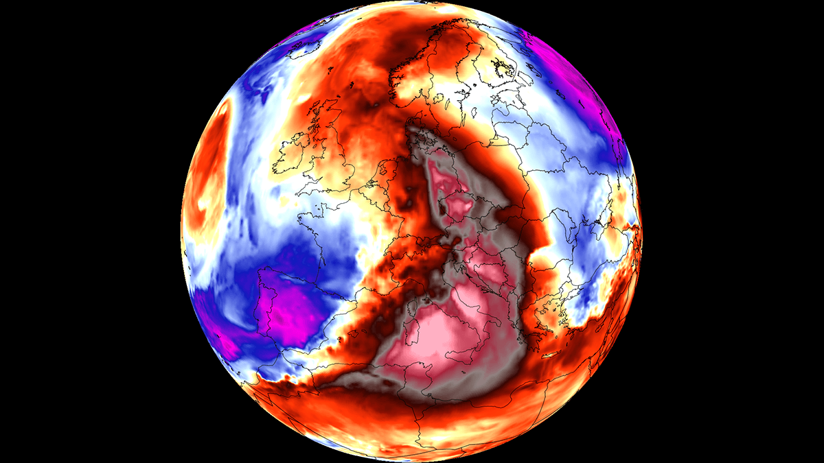
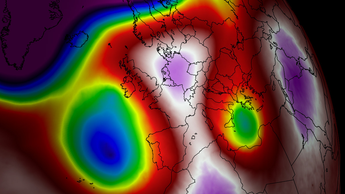
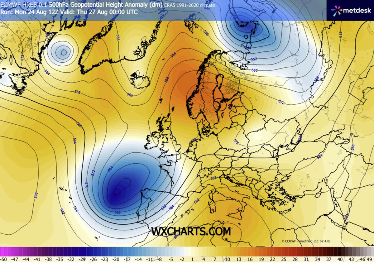
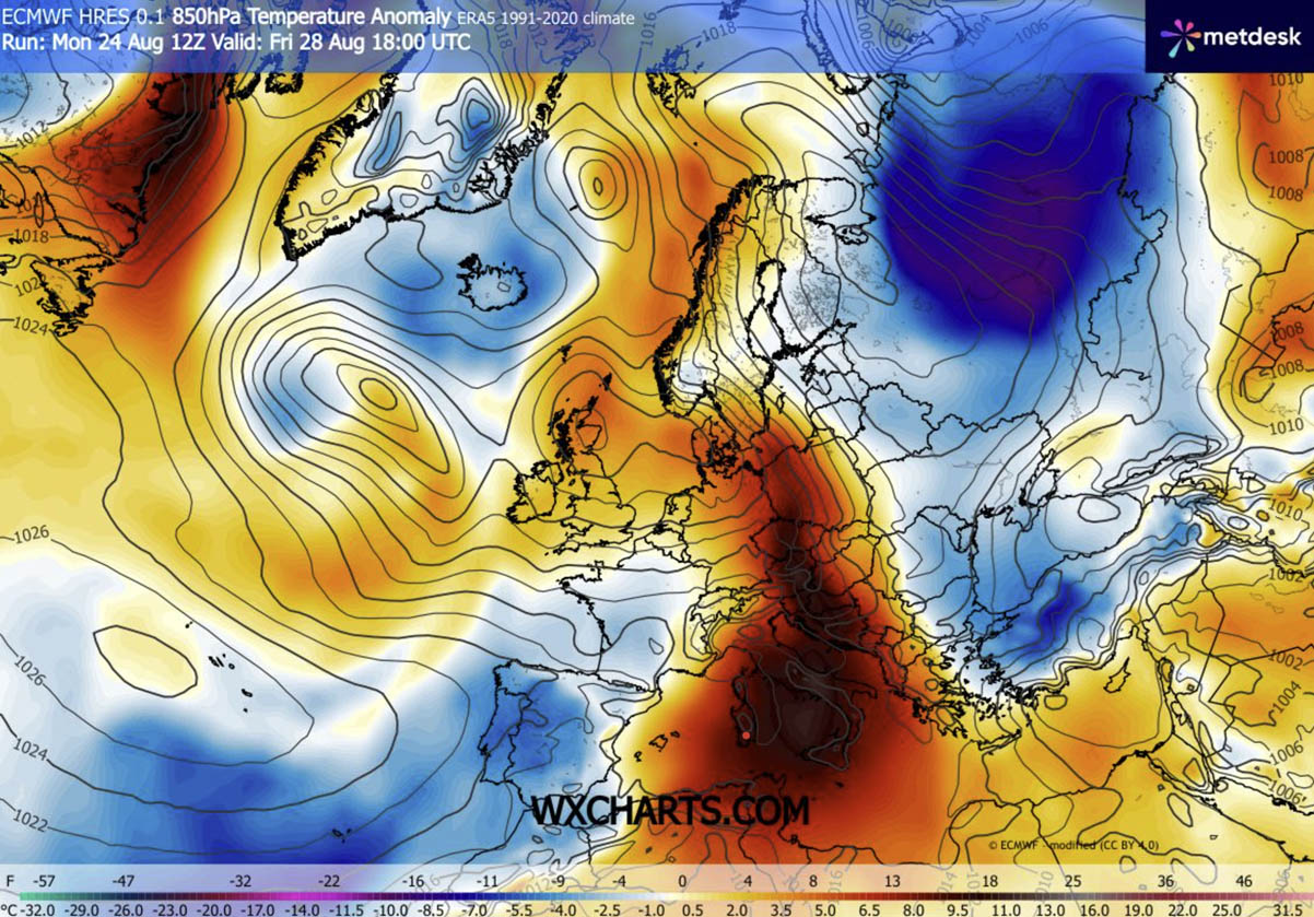
EUROPE — As the meteorological summer draws to a close, large swaths of Southern, Central, and Eastern Europe find themselves locked in the grips of the season’s sixth powerful heat dome. Driven by a stubborn, anomalous blocking high-pressure system anchored over the Central Mediterranean and Southern Europe, this late-summer thermal surge is shattering historical weather boundaries.
Meteorologists warn that peak afternoon temperatures across low-lying river basins and regional plains will soar between 38°C and 43°C (100°F to 109°F) through the end of the week. Combined with dry continental winds rapidly evaporating precious soil moisture, the region faces compounding environmental, physiological, and infrastructural crises.
Main Facts: Anatomy of the Sixth Heat Dome
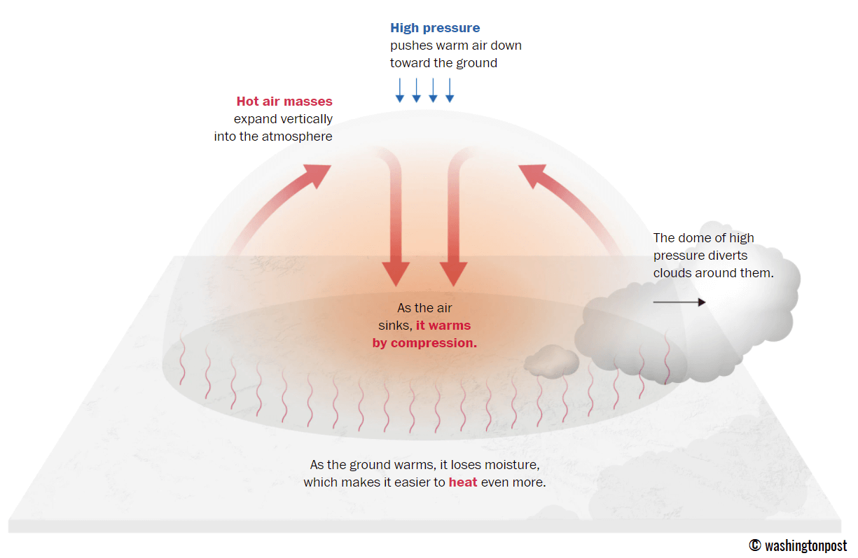
A "heat dome" acts effectively as a massive atmospheric lid. The phenomenon is generated when an upper-level ridge—a sprawling pocket of exceptionally warm air aloft—parks over a vast geographic area and remains stationary for days or weeks.
- The Mechanism: Air beneath the ridge is forced downward. As this air sinks, it undergoes adiabatic compression, squeezing the lower troposphere and causing temperatures to spike rapidly at the surface.
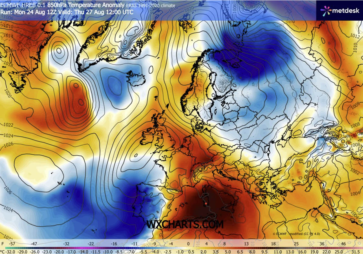
- The Scale: This particular high-pressure anomaly has pulled unseasonably hot air masses directly from North Africa, spreading them across the Mediterranean, Italy, the Balkans, and parts of Central Europe.
- Thermal Anomalies: Surface temperatures are tracking 12°C to 16°C above the long-term climatic norms for late August.
- The Contrast: While southeastern and central sectors bake under blistering heat, a deep upper-level wave over the Bay of Biscay is funneling cooler Atlantic maritime air into Portugal, western Spain, and eventually Western Europe, creating a stark continental divide in weather conditions.
Chronology: How the Late-August Thermal Surge Unfolds
The progression of this weather event has been tracked meticulously by European forecasting agencies, dictating a shifting landscape of danger from mid-week through the upcoming weekend.
Mid-Week: The Peak in the Mediterranean and Italy
By Wednesday and Thursday, the core of the heat dome established itself firmly over the central Mediterranean basin and the Italian peninsula. The Po Valley in northern Italy, southern Italy, and parts of Greece began seeing thermometer readings climbing toward the low-to-mid 40s. Simultaneously, a warm thermal plume surged northward across the Alps, pushing daytime highs in Germany and parts of the Alpine region into the 32°C to 36°C bracket by Thursday afternoon.
Friday: Maximum Intensity Across the Balkans
Friday marks the physiological peak of the heatwave for the central Balkans. Countries including Bosnia and Herzegovina, Serbia, Croatia, and Hungary are enduring the worst of the thermal surge. Daytime highs in the Pannonian plains are projected to peak between 41°C and 43°C, challenging long-standing historical records for the final days of August.
The Weekend Shift: Eastward Expansion and Western Relief
As the weekend arrives, the elongated upper-level ridge will shift eastward. The extreme heat will propagate into Poland, western Ukraine, and the broader Balkan interior. Meanwhile, relief is finally in sight for Western Europe. The cooler Atlantic maritime air mass will push eastward, flushing out the residual heat from France, Germany, and the Low Countries, and bringing much-needed environmental normalization to western territories.
Supporting Data and Meteorological Metrics
Understanding the severity of this event requires looking past simple daytime thermometers to evaluate nocturnal baselines, thermodynamic energy, and atmospheric pressure gradients.
The Danger of "Tropical Nights"
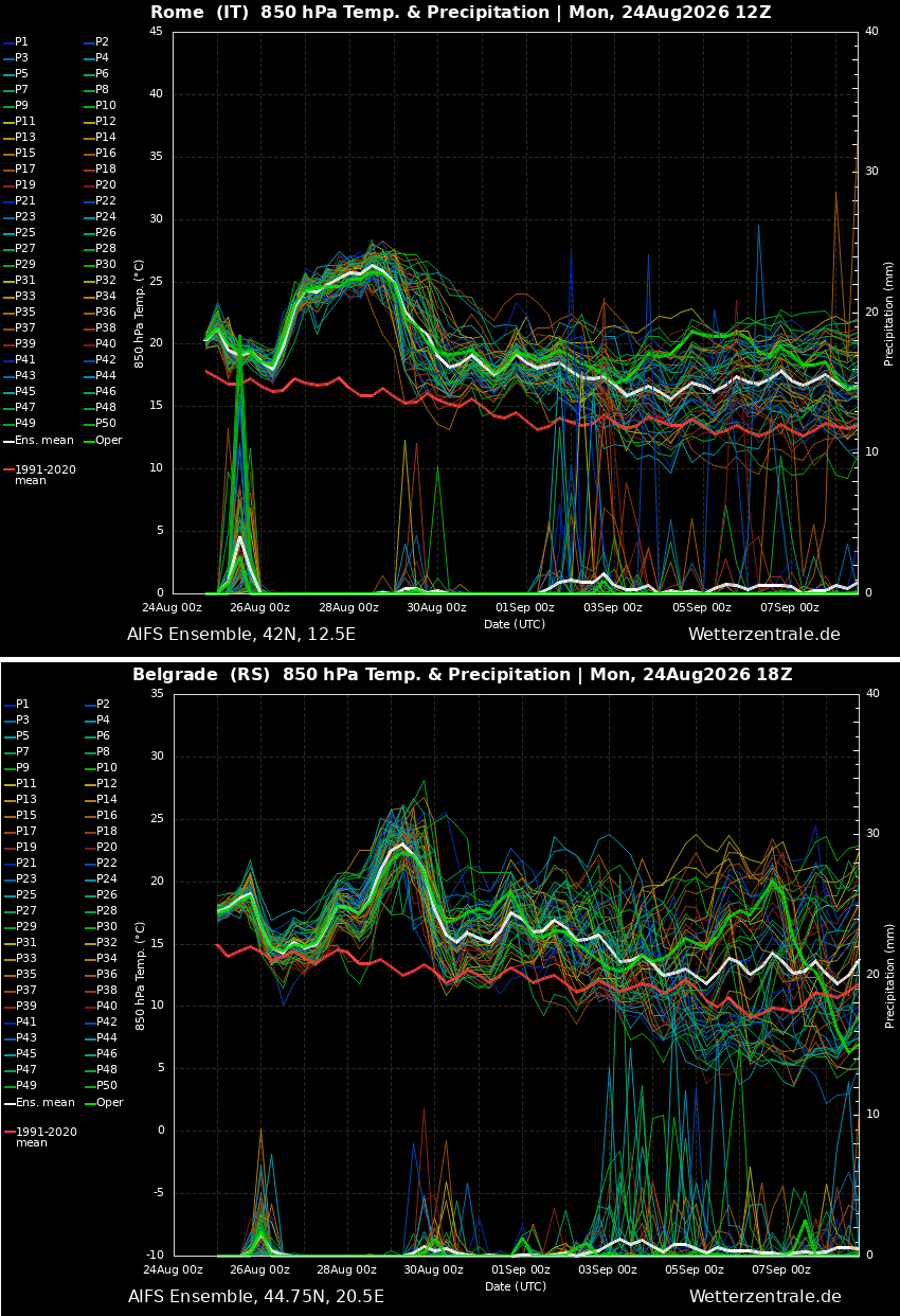
Perhaps the most insidious feature of this heat dome is the lack of nocturnal recovery. Major urban corridors—including Rome and Belgrade—are recording overnight lows refusing to drop below 22°C to 26°C (72°F to 79°F). In densely built environments, these "tropical nights" prevent the human body from shedding accumulated thermal stress, exponentially increasing health risks for vulnerable demographics.
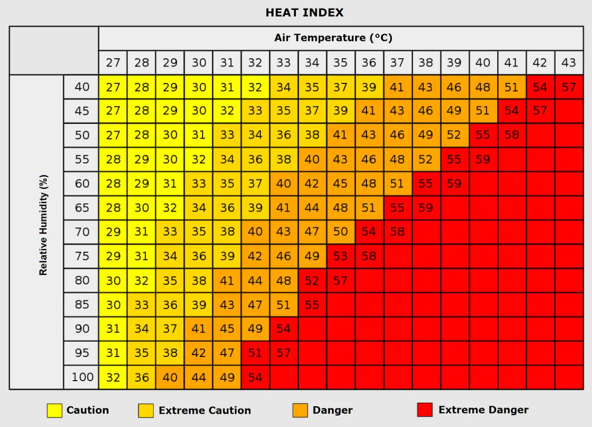
Humidity and the Heat Index
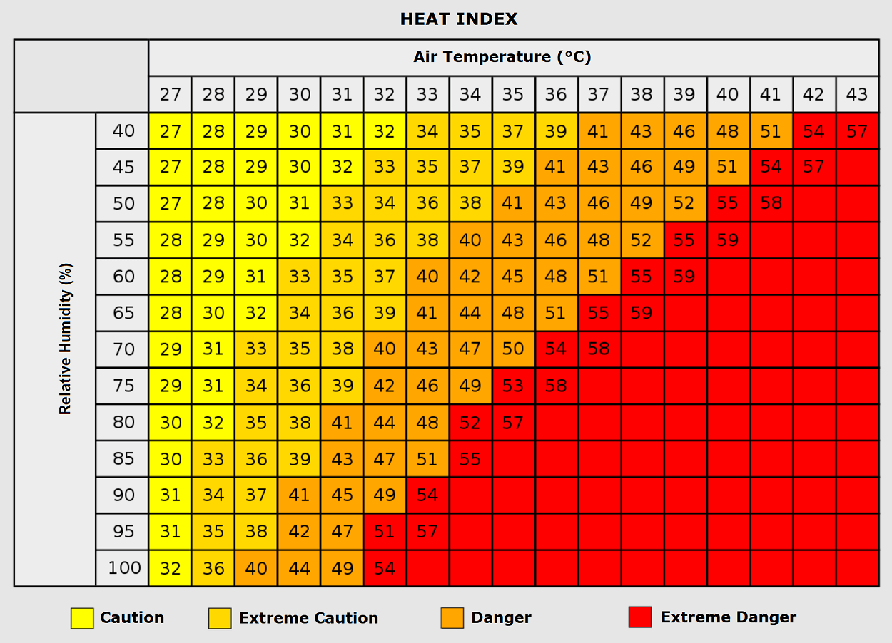
High relative temperatures are compounded by humidity levels in certain regional microclimates. While dry heat can be managed through perspiration, high humidity prevents sweat evaporation. Meteorologists utilize the Heat Index to demonstrate that an air temperature of 35°C paired with high humidity can easily yield a perceived "feels-like" temperature scaling toward 50°C (122°F).
Severe Weather Ingredients: The French Storm Threat
While the heat dome dominates the east, the boundary zone in Western Europe tells a violent meteorological story. On Thursday, the sharp temperature and pressure gradient between the Mediterranean ridge and the deep Atlantic trough over Iberia created an intense jet stream.
- Wind Shear: Strong southwesterly winds are streaming from eastern Spain across the western Mediterranean into France, generating volatile vertical wind shear.
- Instability (CAPE): Fueled by a historically warm Mediterranean Sea storing immense thermal energy, Convective Available Potential Energy (CAPE) values are modeled between 3,000 and nearly 5,000 J/kg.
- The Verdict: This toxic mix of extreme instability and wind shear sets the stage for a dangerous severe thunderstorm outbreak across France and the western Alps. Forecasters warn of organized supercells capable of producing giant hail, destructive straight-line winds, torrential downpours, and isolated tornadoes.
Official Responses and Public Health Implications
With temperatures soaring into dangerous territory, civil protection agencies, municipal governments, and health organizations across Southern and Central Europe have activated emergency response protocols.
Public Health Advisories
Public health authorities have issued red-tier heat warnings across Italy, Serbia, Croatia, and Hungary. Governments are urging citizens—particularly the elderly, young children, and those with pre-existing cardiovascular or respiratory conditions—to remain indoors during peak afternoon hours.
Outdoor workers, including agricultural laborers and construction crews, are facing mandated hydration breaks and adjusted shift hours. Officials note that populations living in economically disadvantaged urban housing, which often utilizes heat-retaining concrete and lacks adequate ventilation, remain disproportionately vulnerable to heat exhaustion and fatal heat strokes.
Energy Grid and Infrastructure Strain
The relentless heat has triggered a massive surge in energy demand driven by ubiquitous air conditioning use. Power grid operators in Southern and Central Europe are maintaining high alert statuses to prevent localized blackouts. Furthermore, extreme temperatures are warping railway lines, degrading asphalt infrastructure, and rapidly drying out agricultural fields, setting the stage for explosive wildfire conditions across dry valleys and forest floors.
Broader Implications: A Sign of Changing Seasons
This sixth heat dome of the European summer underscores a rapidly shifting climatic baseline where extreme blocking patterns and prolonged thermal domes are becoming the defining features of the warm season. As August transitions into September, long-term atmospheric models suggest that the broader pattern will remain highly dynamic.
While a temporary breakdown of the ridge is slated for Western Europe this weekend, the atmospheric engine driving these anomalies shows no signs of permanent fatigue. Forecasters and civil authorities alike are being forced to adapt to a reality where late-summer heatwaves behave with mid-summer intensity, posing recurring threats to public health, agriculture, and infrastructure across the continent.
