

Main Facts: A Historic Climate Driver Takes Shape
As meteorologists and long-range forecasters peer deep into atmospheric and oceanic data models, the upcoming Winter 2026/2027 is rapidly taking shape around a rare and exceptionally powerful climate anomaly: a developing Super El Niño.

Latest seasonal forecasts from premier global modeling systems—including the European Centre for Medium-Range Weather Forecasts (ECMWF), the NOAA Climate Prediction Center’s NCEP CFSv2, and the North American Multi-Model Ensemble (NMME)—reveal a strongly amplified, well-defined split-flow weather pattern spanning North America and propagating toward Europe.
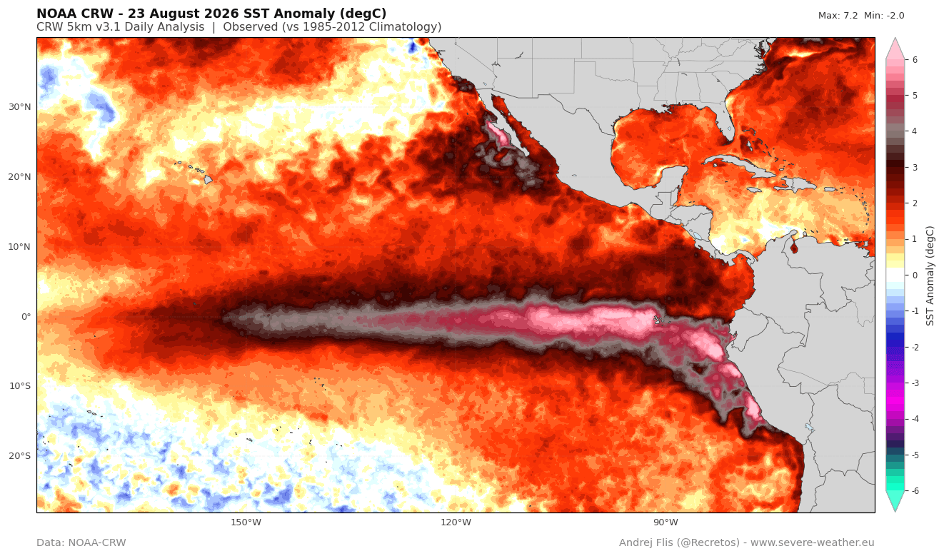
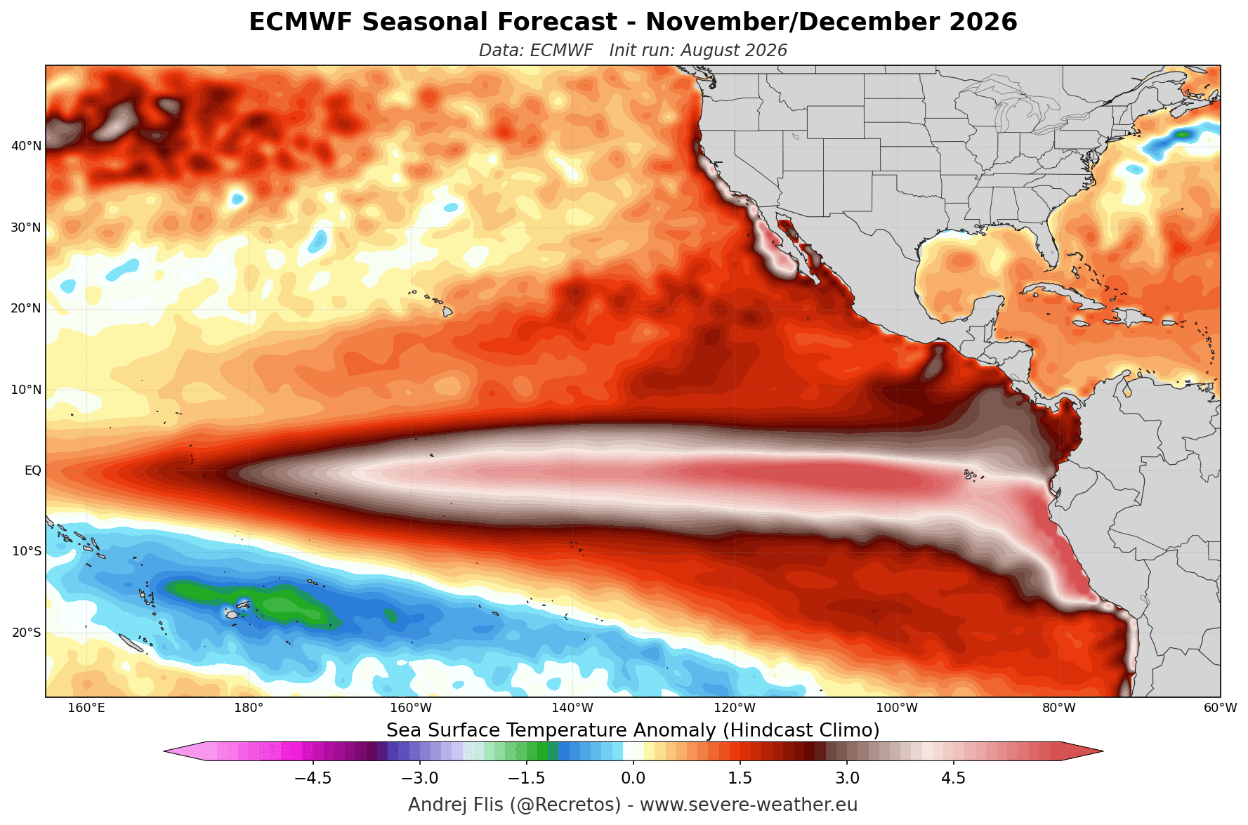
Unlike standard El Niño cycles, which occur every few years with moderate atmospheric consequences, a Super El Niño is classified by sustained equatorial Pacific sea surface temperature anomalies exceeding +2 degrees Celsius above normal for extended seasonal blocks. Current oceanic monitoring via NOAA Coral Reef Watch (CRW) and Optimum Interpolation Sea Surface Temperature (OISST) datasets indicates that anomalies have already breached critical thresholds, with localized pockets surging past +6°C above normal. Beneath the surface, a massive downwelling Kelvin Wave—characterized by subsurface temperature anomalies more than 9°C (16°F) above average within the top 250 meters of the tropical Pacific—is actively supplying continuous thermal energy. This guarantees that the ocean heat engine will remain robust, healthy, and fully engaged throughout the core of the winter season.
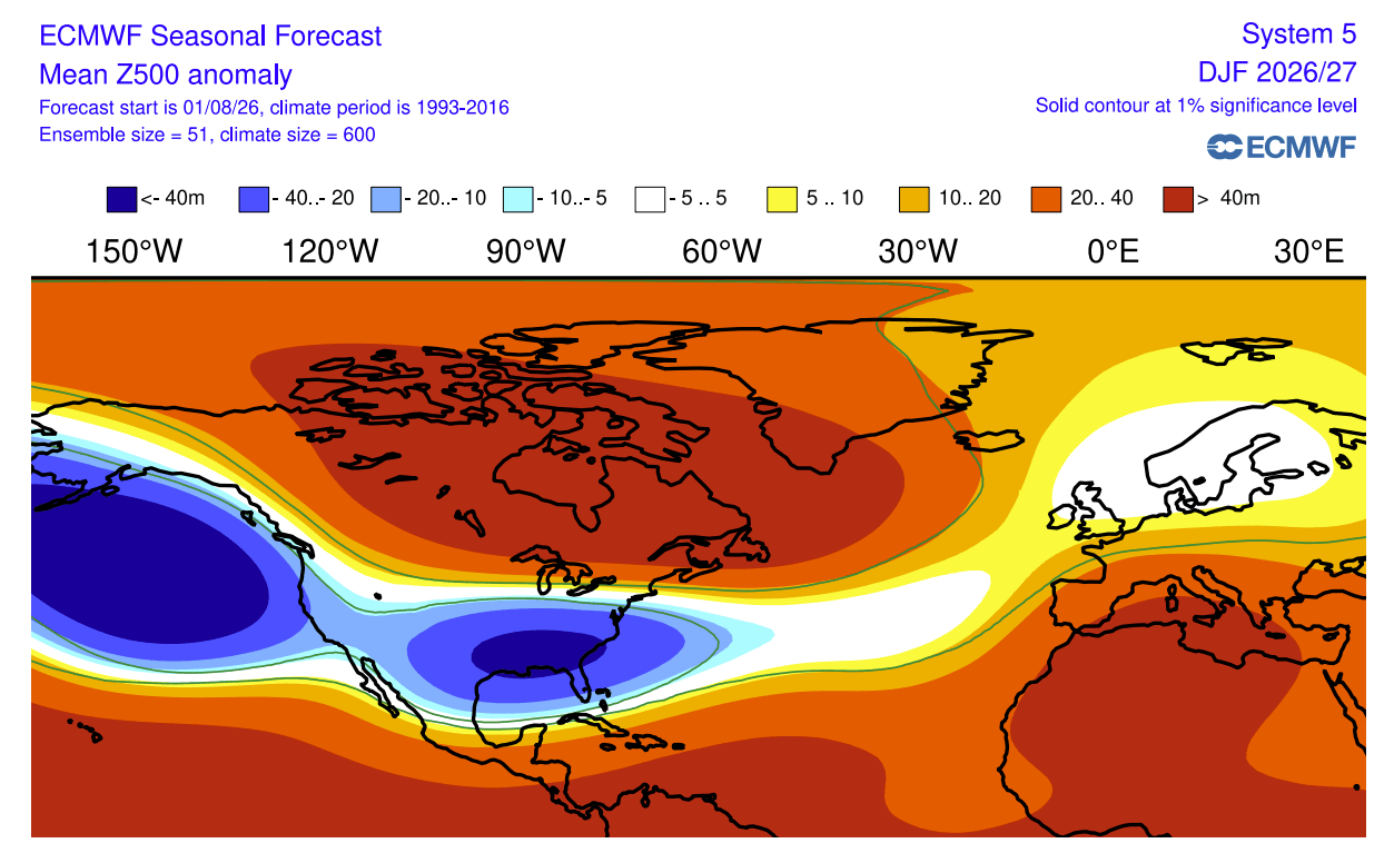
The resulting planetary wave train will force a dramatic atmospheric domino effect across the Northern Hemisphere. For North America, this means a deep, expansive Aleutian low-pressure trough over the North Pacific, a massive blocking high-pressure ridge over Canada and the northern United States, and an active subtropical jet stream driving stormy, moisture-rich conditions across the southern and eastern tiers of the U.S. Meanwhile, Europe faces a prevailing westerly and southwesterly Atlantic flow, skewing overall continental temperatures toward milder-than-average regimes while keeping snowfall heavily dependent on altitude and latitude.
Chronology: The Evolution Toward an Extreme Event
The trajectory toward the Winter 2026/2027 Super El Niño has been tracked through distinct phases of atmospheric and oceanic development:
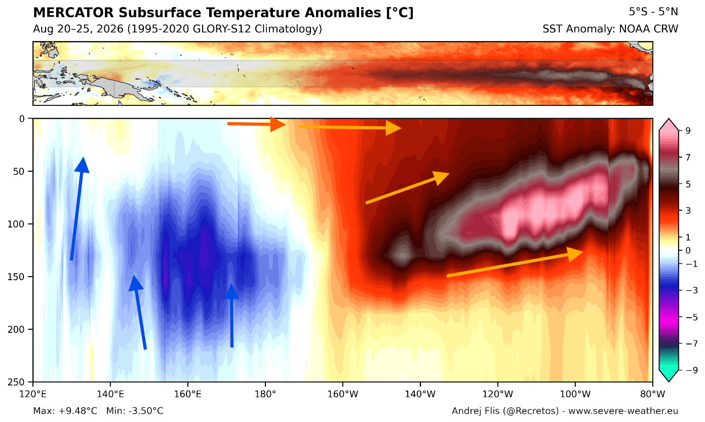
- Late Spring and Summer 2026: Continuous upwelling and westerly wind bursts in the western equatorial Pacific begin displacing warm upper-ocean waters eastward. This initiates a powerful downwelling Kelvin Wave, which visibly propagates across ocean surface tracking models.
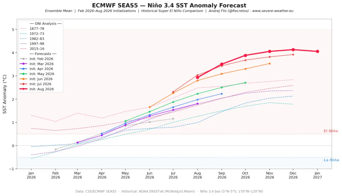
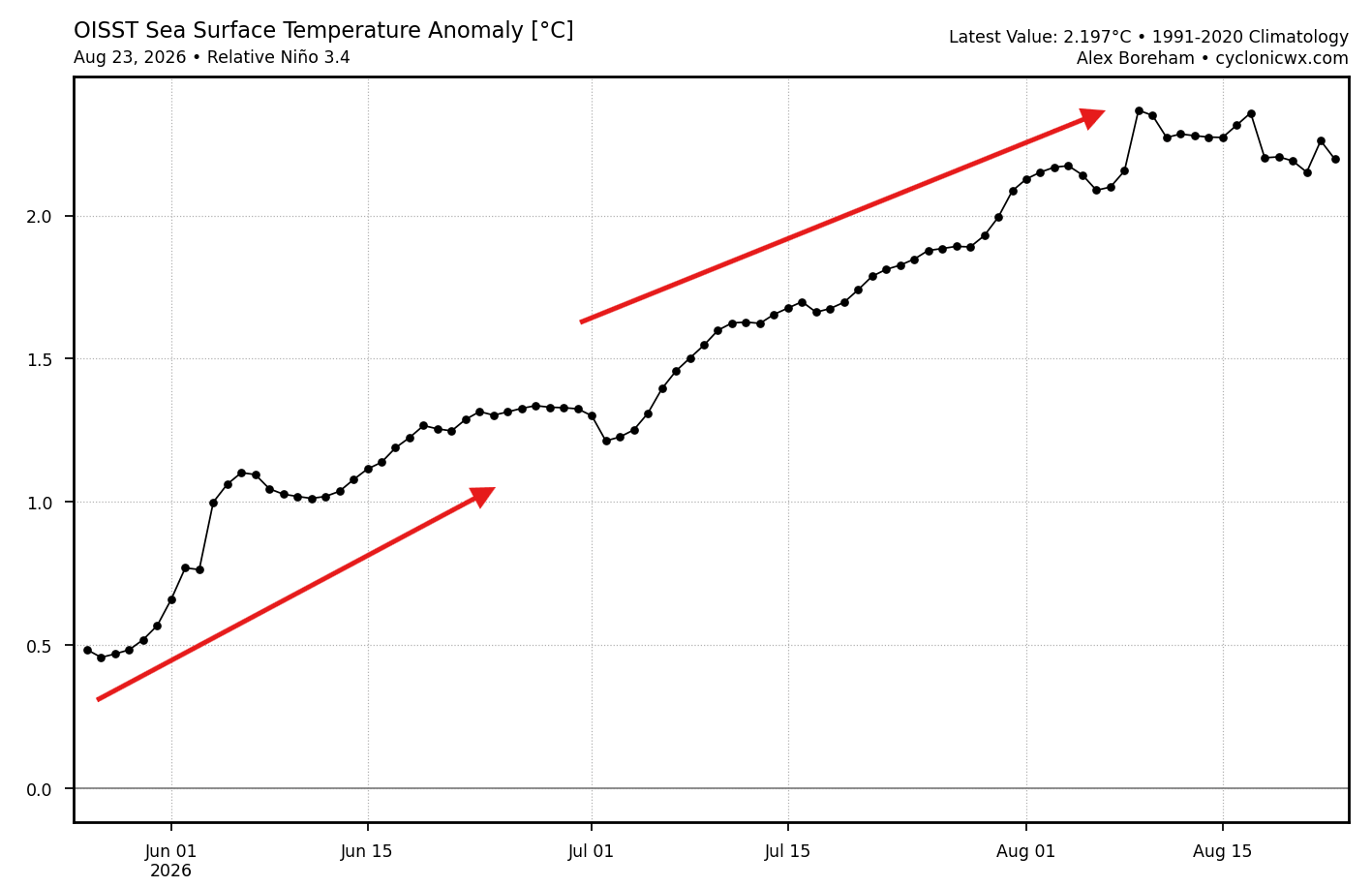
- August through September 2026: NOAA-CRW and OISST data confirm that oceanic heat anomalies accelerate past standard El Niño baselines, officially entering Super to Extreme event territory. Seasonal forecast runs, particularly from the ECMWF SEAS5 model, begin adjusting upward month-over-month, consistently projecting a higher peak anomaly than previously simulated.
- Autumn 2026: Subsurface thermal structures tilt the Pacific thermocline, locking in an extreme baseline state. Atmospheric bridge mechanisms—specifically the disruption of the tropical Walker Circulation—begin launching planetary-scale Rossby wave trains toward both hemispheres.
- Late December 2026 through January 2027 (Projected): Global numerical weather prediction systems signal an unusual deceleration and early weakening of the stratospheric Polar Vortex. As wave energy from the Pacific surges vertically into the stratosphere, zonal westerly winds slow down, setting the stage for potential mid-winter disruptions.
- February 2027 (Projected): Atmospheric pressure patterns reach their maximum seasonal amplification. The Canadian blocking ridge and the active southern jet stream form an entrenched split-flow highway, maximizing temperature contrasts and storm tracks across the Northern Hemisphere before the El Niño event begins its eventual spring-season decay.
Supporting Data and Model Analysis: The Science Behind the Forecast
To validate a long-range forecast of this magnitude, meteorologists rely on multi-model consensus and historical analogs from past extreme events.
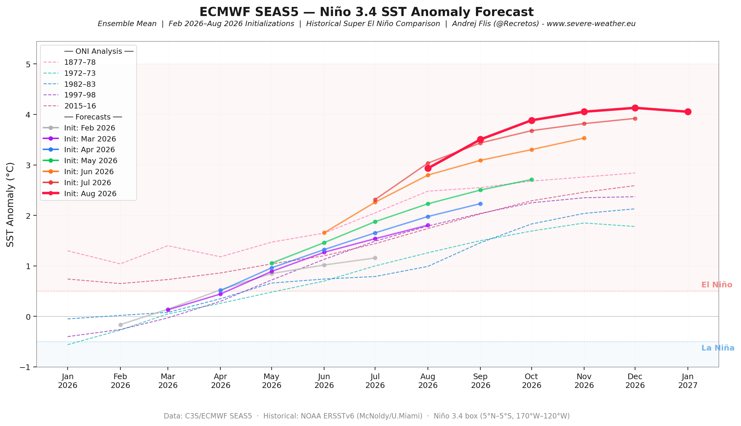
Ocean Heat and the Kelvin Wave Engine
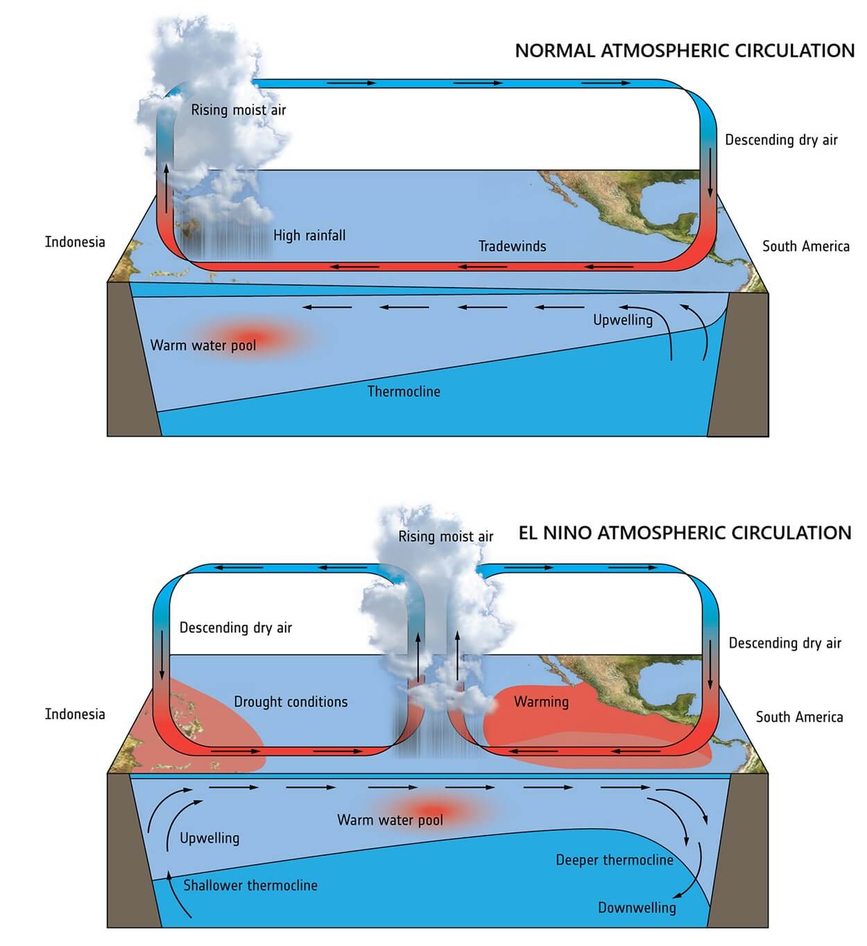
The core driver of Winter 2026/2027 resides deep within the equatorial Pacific. The Walker Cell—the tropical atmospheric circulation loop defined by rising motion over warm waters and sinking motion over cooler regions—is intensely modified during strong ENSO phases. Low pressure drops across the central and eastern tropical Pacific, while high pressure builds over the western basins.
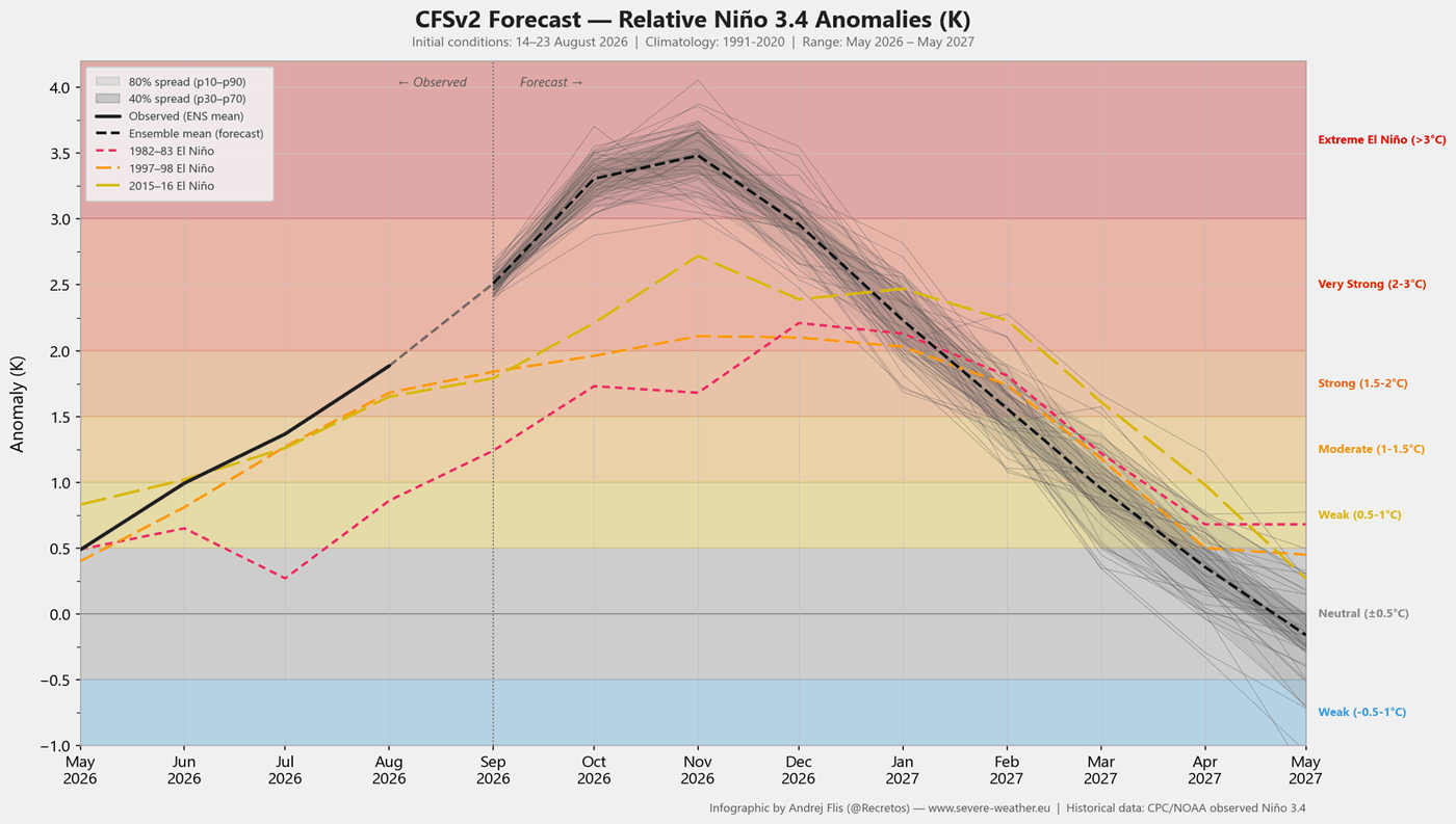
Data from NOAA NCEP CFSv2 and ECMWF runs confirm that the basin-wide ENSO strength for late 2026 will rank among the most potent on record. The sustained sea surface temperature anomalies exceed the traditional +2°C Super El Niño threshold, with some model ensembles pushing toward a +3°C departure. This colossal reservoir of heat guarantees that the atmosphere will continuously experience anomalous tropical forcing through the entirety of the cold-weather season.
North American Pressure and Temperature Patterns
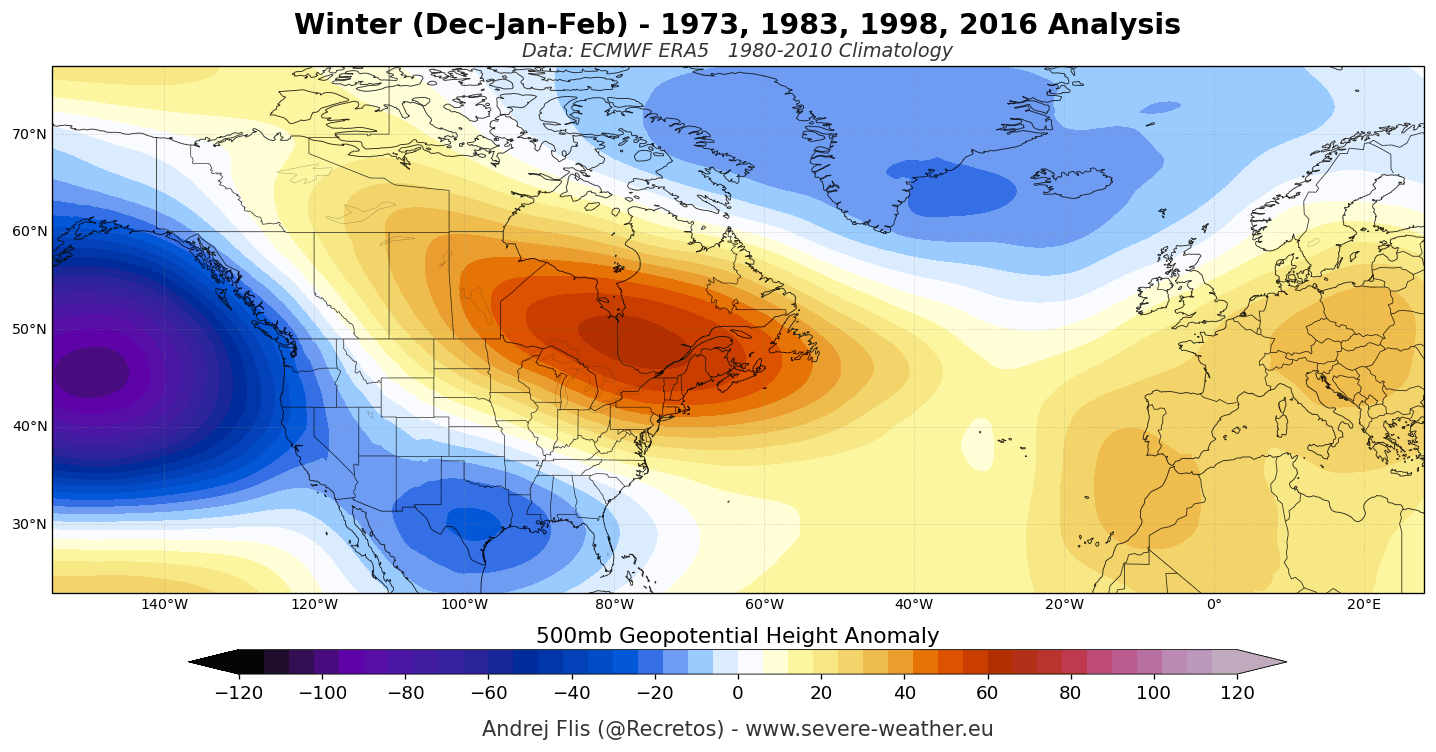
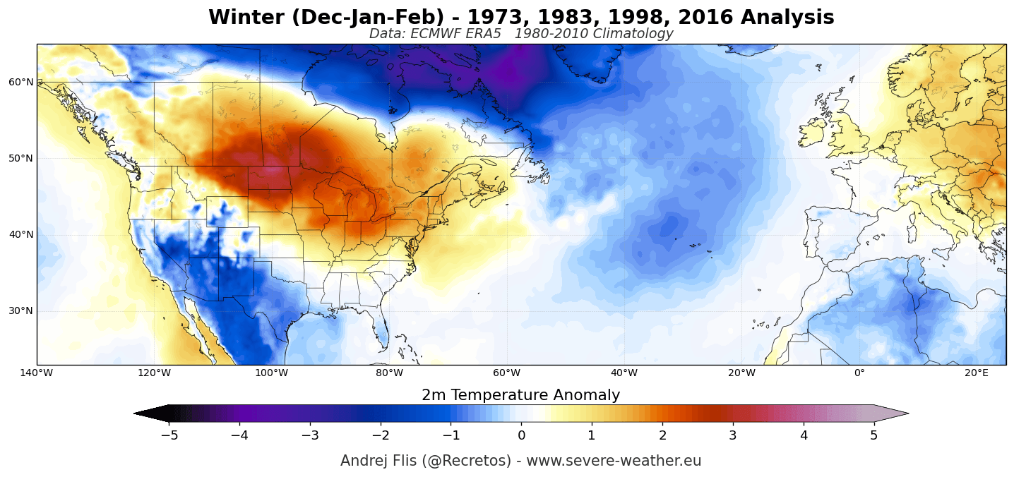
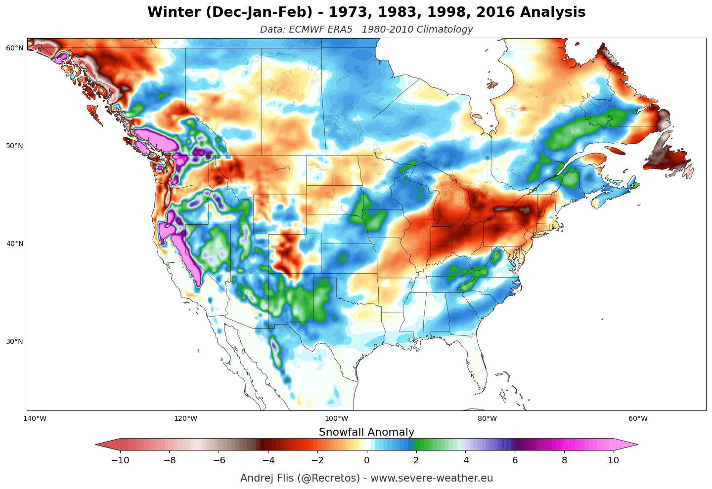
When analyzing historical composites of the last four major Super El Niño winters, a stark, repeating structural pattern emerges:
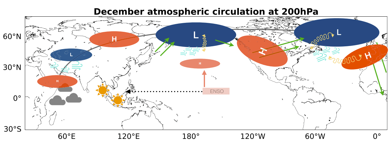
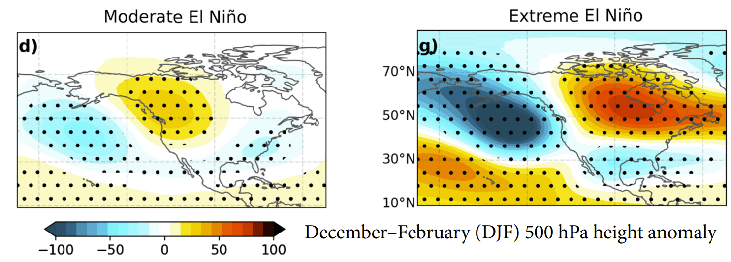
- Pressure Anomalies: A deep 500mb geopotential height low-pressure anomaly anchors over the North Pacific, forcing an intense high-pressure ridge to build across western Canada, the Upper Midwest, and the Great Lakes. Downstream, lower pressures dominate the southern United States and the North Atlantic.
- Temperature Contrasts: Well above-normal temperatures lock in across Western and Central Canada, the Northern Plains, and the U.S. West Coast. Conversely, persistent cloud cover and frequent storm passages keep the southern U.S., Texas, the Gulf Coast, and the Southeast cooler than average.
- Precipitation and Snowfall: The active southern jet stream funanders heavy precipitation across California, the Southwest, the Four Corners, the Southern Rockies, and the Central Plains, favoring high-elevation snowpack in those regions. Meanwhile, the Pacific Northwest, Great Lakes, Ohio Valley, and Northeast experience noticeable snowfall deficits due to suppressed northern storm tracks and mild Canadian air masses.
The latest ECMWF and NOAA NMME forecasts for Winter 2026/2027 match these historical blueprints with striking precision, showing deep Southern U.S. storm tracks and persistent northern ridging.
The European Perspective
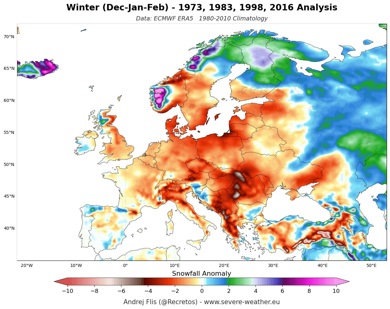
Across the Atlantic, the Super El Niño teleconnection manifests differently. The dominant North Atlantic Oscillation and Pacific-European teleconnections favor an active westerly and southwesterly flow from the Atlantic ocean. Both ECMWF and NMME models project widespread above-average temperatures across mainland Europe for December through February. While precipitation totals are expected to be above normal due to moisture-laden Atlantic systems pushing inland, lowland and mid-elevation snowfall will face severe deficits. Natural snow accumulation will be largely restricted to high-altitude alpine zones (typically above 1,800 to 2,000 meters) in western and central Europe, as well as northern and northeastern latitudes where cold air can successfully pool.
Official Responses and Meteorological Insights
Leading meteorological institutions and research groups emphasize that while Super El Niños provide a powerful, predictable baseline, atmospheric interactions remain dynamic.
Forecasters highlight the critical role of the stratospheric Polar Vortex as a secondary wild card. The Polar Vortex acts as a spinning containment wall of high-altitude winds trapping polar air. However, research into past Super El Niño events demonstrates that intense tropical wave energy can propagate upward into the stratosphere, destabilizing the vortex during mid-winter.
Both the ECMWF and UK Meteorological Office (UKMO) 10hPa zonal wind forecasts are currently highlighting a pronounced slowdown of stratospheric westerly winds slated for late December and January. While this does not automatically guarantee a Sudden Stratospheric Warming (SSW) event months in advance, it indicates an atmospheric state highly sensitive to disruption. If a vortex breakdown successfully propagates downward into the troposphere, it can occasionally override standard El Niño baselines, introducing sudden, severe cold-air outbreaks into the mid-latitudes—a phenomenon colloquially tracked as the "Polar Express" pattern.
Implications: Sector-by-Sector Impacts for Winter 2026/2027
The convergence of a record-setting Super El Niño, an entrenched North American split-flow regime, and a potentially unstable Polar Vortex carries profound implications across multiple industries:
Agriculture and Water Resources
- Western United States: The amplified southern storm track and high-elevation snowfall across the Sierra Nevada, Utah, and the Southern Rockies will provide critical water resource replenishment for reservoirs in California and the Southwest following dry spells.
- Northern Tier & Canada: Milder conditions and reduced snowpack across the Pacific Northwest, Northern Plains, and parts of Canada may lead to lower spring soil moisture recharge and early snowmelt cycles.
Winter Tourism and Recreation
- Ski Resorts (North America): A distinct north-south bifurcation will define the ski industry. Resorts in California, Utah, Arizona, New Mexico, and Colorado are poised for abundant southern-stream snowfall. Conversely, operators in the Pacific Northwest (Cascades, British Columbia), Idaho, Montana, and Northern New England face challenging conditions with below-average natural snowpacks and persistent warmth.
- Ski Resorts (Europe): Lowland and mid-elevation resorts across the Pyrenees, Apennines, and Balkans will struggle with mild Atlantic air. Winter sports enthusiasts must target high-altitude zones in the Western and Central Alps or travel to northern European destinations to secure reliable snow conditions.
Energy and Infrastructure
- Energy Demand: Milder winter forecasts across Canada, the Northern U.S., and mainland Europe are expected to moderate residential heating demand and energy consumption during peak months. However, the potential for severe storm tracks across the Southern and Eastern U.S. elevates the risk of disruptive ice storms, heavy rainfall events, and localized infrastructure stress driven by active subtropical jet stream dynamics.
As Winter 2026/2027 approaches, forecasters will continue monitoring real-time oceanic shifts and stratospheric wind anomalies. Stakeholders across North America and Europe are advised to stay tuned to ongoing updates as the atmospheric machinery locks into its historic Super El Niño configuration.
