

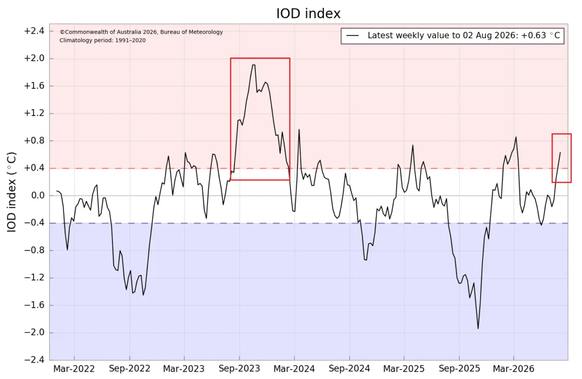
As the Northern Hemisphere transitions through the latter half of the year, meteorologists and climatologists are tracking an extraordinary convergence of global ocean anomalies. A rapidly strengthening Super El Niño across the tropical Pacific is now locking horns with a newly developing positive Indian Ocean Dipole (IOD).

According to seasonal long-range outlooks, this powerful dual-ocean atmospheric system will exert a profound forcing mechanism on global weather patterns. By combining tropical heat, wind anomalies, and synchronized wave trains, this dual-engine setup is projected to heavily dictate jet stream behavior, temperature departures, and snowfall trends across the United States, Canada, and Europe for the upcoming Winter 2026/2027 season.
Main Facts: The Anatomy of a Dual-Ocean Climate Engine
The Earth’s climate system is heavily influenced by teleconnections—large-scale climate patterns that link weather across vast distances. For the upcoming winter, two distinct tropical phenomena are joining forces:
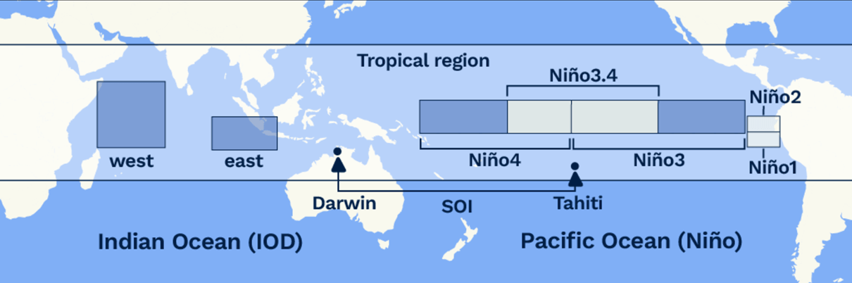
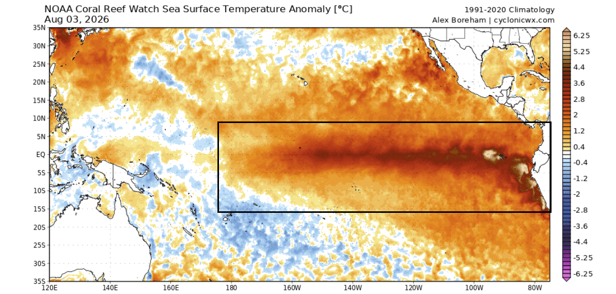
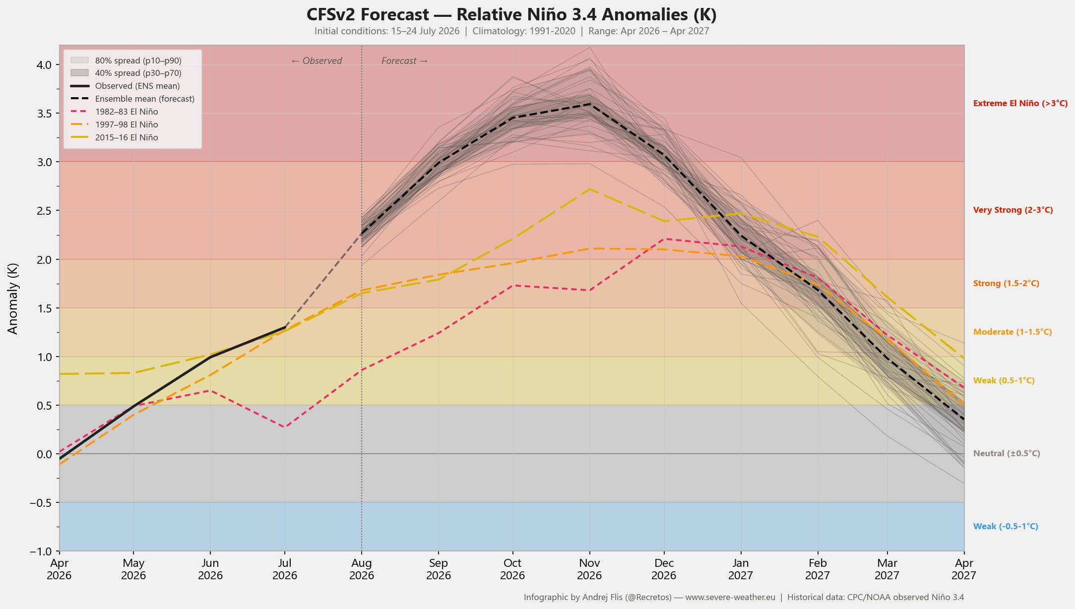
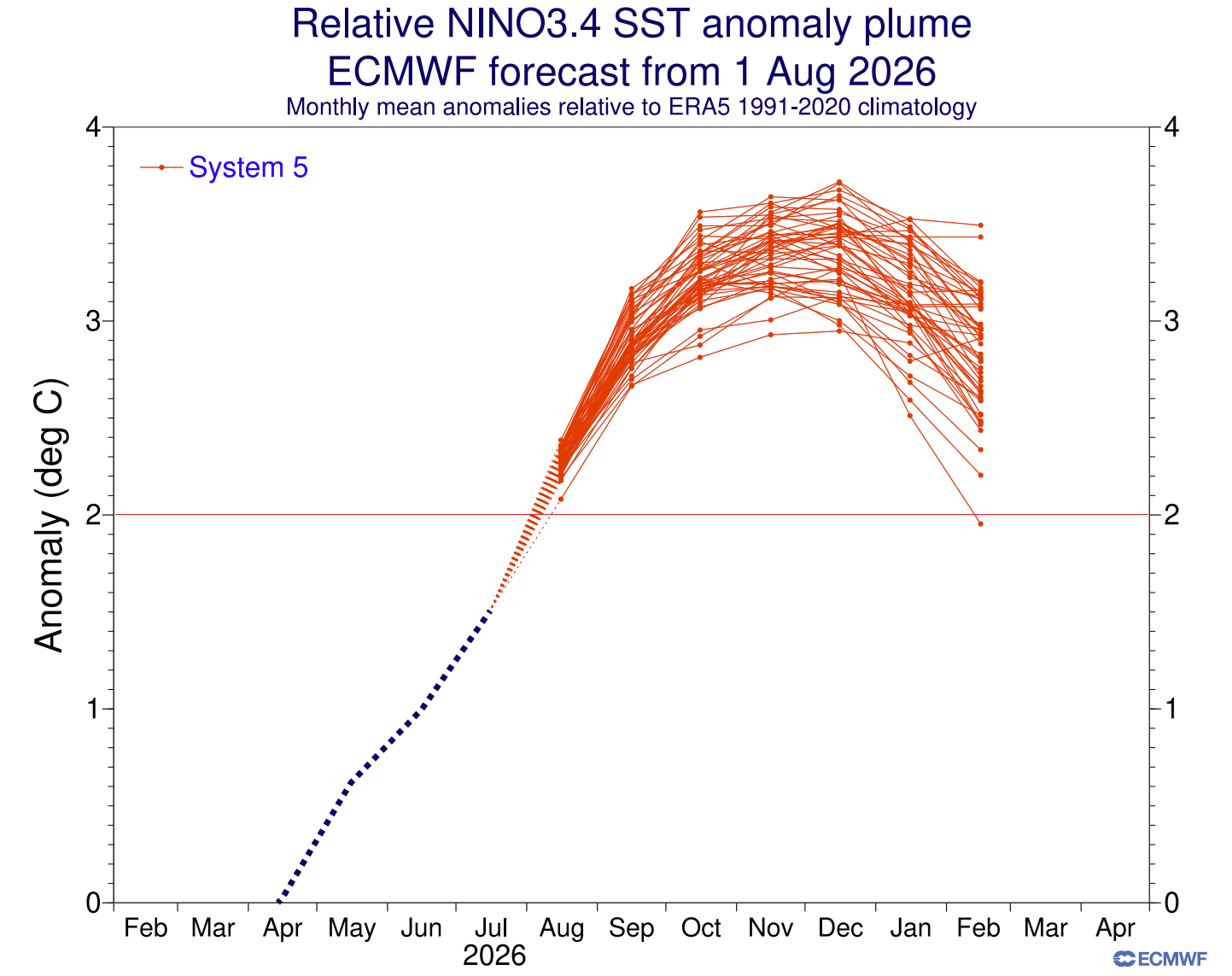
- The Super El Niño: Emerging rapidly across the central and eastern tropical Pacific, subsurface ocean temperatures have already surged to levels well above normal. Leading global models from NOAA/NCEP and the ECMWF suggest this event could peak at historic thresholds, with surface anomalies potentially exceeding +3°C to +4°C above baseline averages.
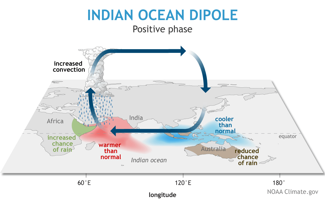
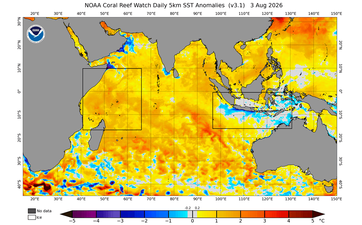
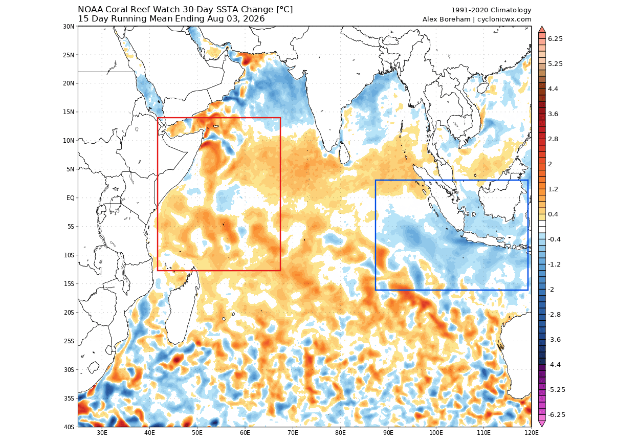
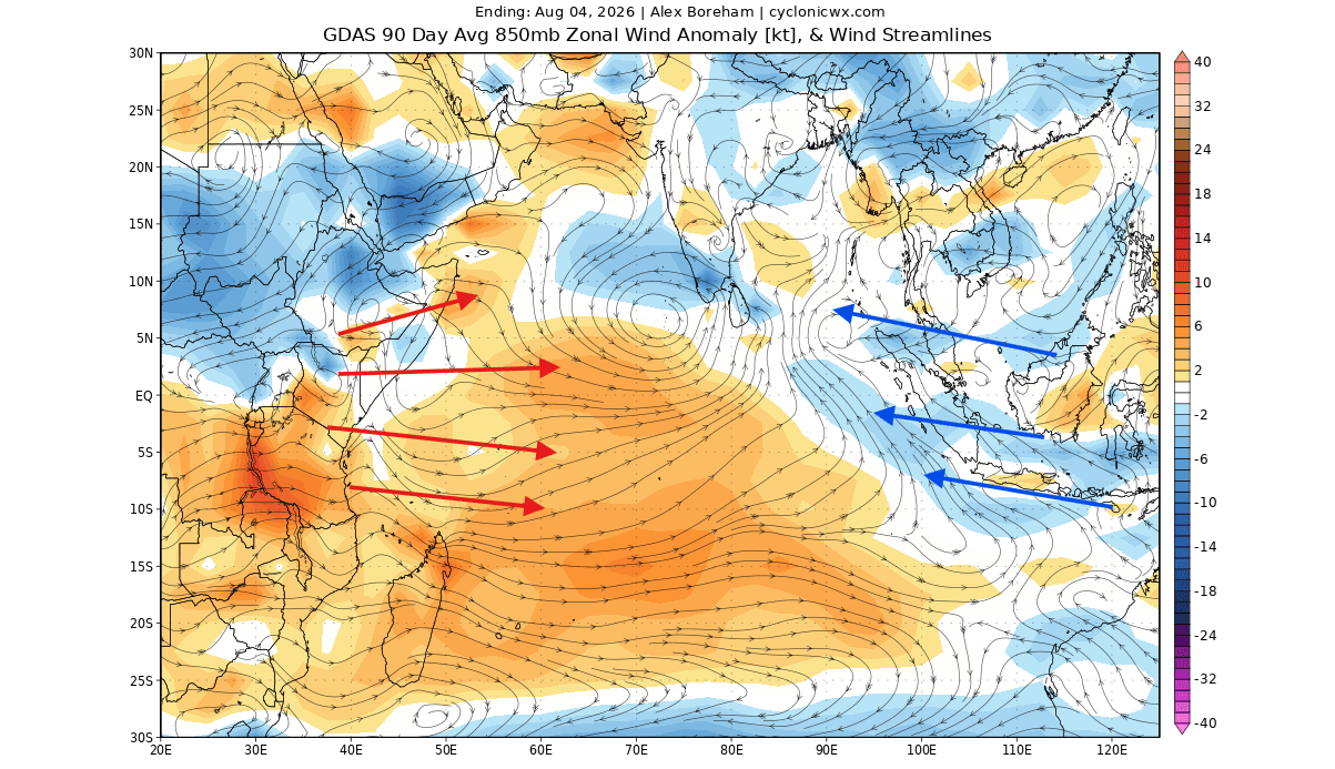
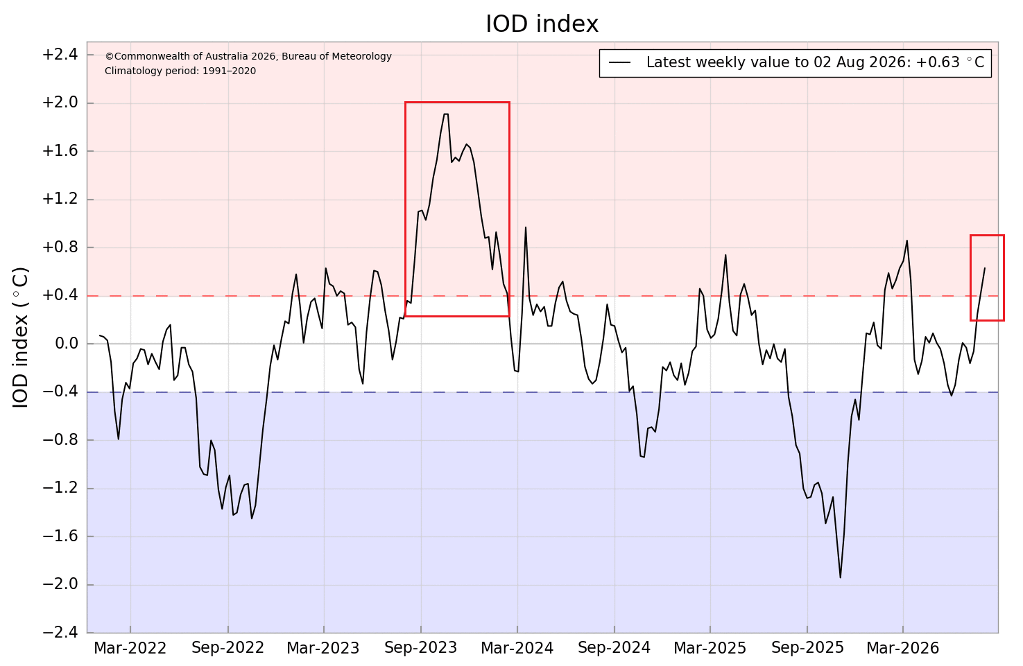
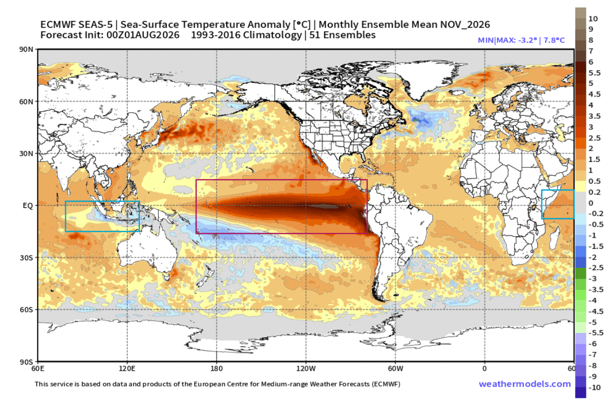
- The Positive Indian Ocean Dipole (IOD): Characterized by an east-west temperature imbalance across the Indian Ocean, a positive IOD phase features cooler-than-average waters in the east and warmer waters in the west. This ocean temperature gradient alters regional trade winds and convection, establishing a massive tropical atmospheric cell.
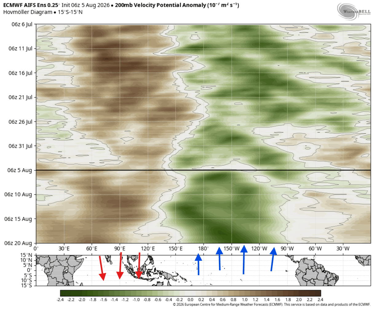
- Synchronized Forcing: Rather than operating in isolation, the Super El Niño and the positive IOD are linked through atmospheric pressure, trade wind variations, and tropical rainfall anomalies. Together, they act as a singular global weather engine, launching planetary-scale Rossby wave trains that ripple from the tropics straight into the mid-latitudes.
Chronology of Development: From Summer Signals to Winter Locks
Understanding how these anomalies translate into mid-latitude winter weather requires looking at their evolution across the calendar year.
Summer Acceleration (August)
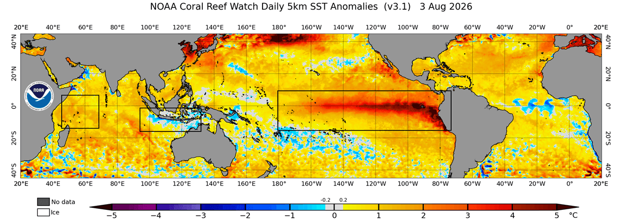
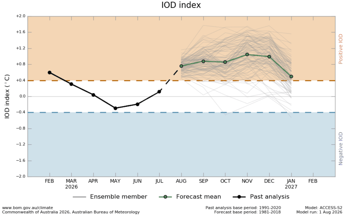
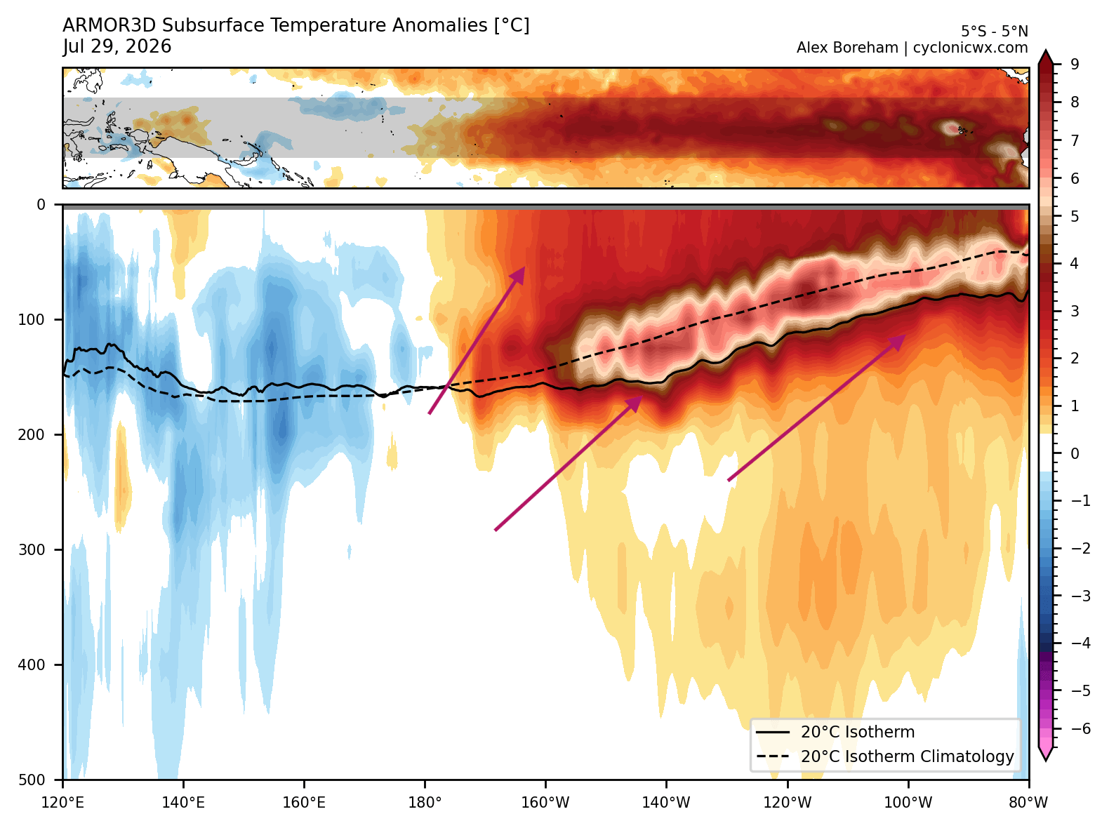
By early August, oceanic and atmospheric monitoring revealed significant acceleration in the Pacific basin. Subsurface analysis highlighted a massive Kelvin Wave—a vast pocket of warm water traveling eastward beneath the surface propelled by weakening easterly trade winds. As this warm core approached the eastern tropical Pacific, it began rising to the surface, cementing the early stages of a historic Super El Niño. Simultaneously, the Indian Ocean began registering a textbook positive IOD signal, with surface cooling intensifying off the coast of Sumatra and warming taking hold in the western basin.
Fall Transition (September – November)
As the calendar turns toward autumn, seasonal forecasts from the European Centre for Medium-Range Weather Forecasts (ECMWF) indicate that the positive IOD phase will firmly lock in place, persisting through Fall and into early Winter. This sustained phase guarantees that tropical rainfall and atmospheric circulation anomalies will remain active. The persistent rising air over the central Pacific and Indian Ocean, paired with stable sinking air over Indonesia, anchors the global atmospheric standing wave.
Early-to-Late Winter Amplification (December 2026 – February 2027)
By December, the tropical forcing cascades poleward, establishing the definitive pressure patterns for Winter 2026/2027. Real-world data and ensemble computer models suggest that actual winter storm tracks will feed aggressively off this tropical energy, locking the jet stream into a high-amplitude wave pattern much faster than standard climate models typically project.
Supporting Data: Oceanic Analysis and Model Projections
The empirical evidence supporting this forecast is derived from decades of climate data, satellite telemetry, and advanced multi-model ensemble runs.
Pacific Basin Metrics
OISST sea surface temperature analyses from early August show widespread positive anomalies spanning the central and eastern ENSO regions. More critically, vertical ocean profiling of the top 500 meters (1,640 feet) reveals a deep-core subsurface temperature anomaly exceeding 8°C above normal. Both the NOAA NCEP CFSv2 and ECMWF models project that sea surface temperatures in the Niño 3.4 region will surpass the official "Super El Niño" threshold (+2°C) by a wide margin, potentially rivaling some of the strongest recorded events in modern meteorological history.
Indian Ocean Dynamics
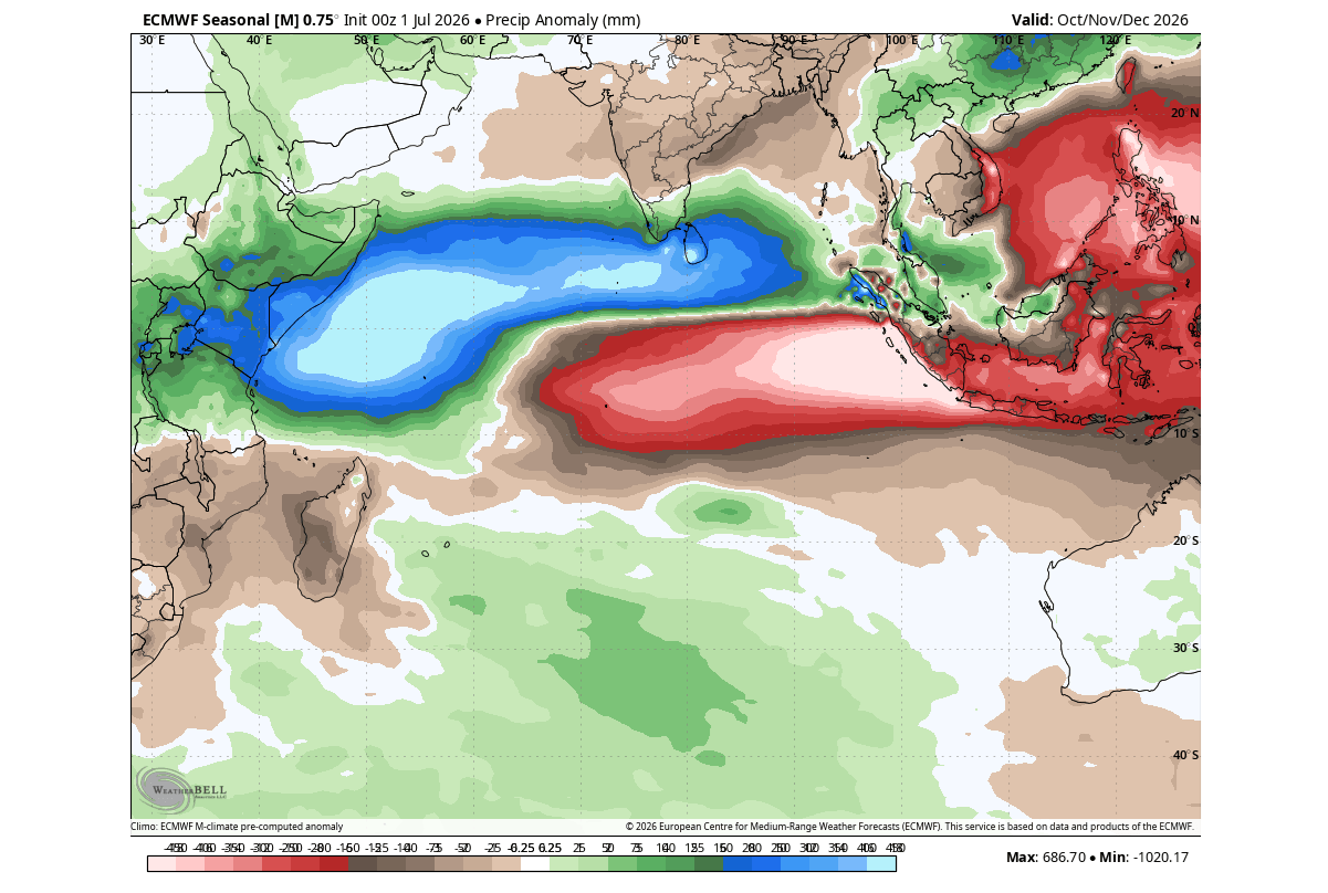
Thirty-day zonal wind anomalies in the lower troposphere demonstrate a clear weakening of trade winds across the Indian Ocean, facilitating western basin warming, alongside localized strengthening of winds in the east that drive the positive IOD cooling trend. Precipitation anomaly forecasts for the Indian Ocean sector reflect this shift, displaying massive rainfall deficits in the east and significant surpluses in the west.
Implications for North America: Split-Flow Patterns and Snowfall Trends
Historical analogues spanning the last 65 years—combined with the latest ECMWF ensemble runs—point toward a classic El Niño winter regime over North America, enhanced by the concurrent positive IOD.
Pressure and Temperature Anomalies
The overarching pressure pattern features a pronounced high-pressure blocking ridge anchored over Canada, coupled with a deep, energetic low-pressure trough extending from the North Pacific across the southern and eastern United States.
- Canada and the Northern U.S.: Dominated by the persistent northern blocking ridge, these regions are favored to experience milder-than-normal temperatures and reduced overall snowfall anomalies. The ridge acts as an atmospheric barrier, frequently deflecting polar air masses away from higher latitudes.
- The Southern and Eastern U.S.: Under the influence of an active southern storm track and frequent low-pressure passages, areas from Texas and the Gulf Coast across to the Southeast and Mid-Atlantic are projected to see cooler-than-normal temperature trends and heightened precipitation.
Snowfall Potential
Because an active southern jet stream intersects with periodic, southward-drifting cold air injections from the north, the primary winter storm corridor is displaced further south than in a neutral year.
- Lower Snowfall: The Pacific Northwest, northern Great Lakes, and southern Canada face below-average snowfall due to persistent warmth and the northern high-pressure ridge.
- Higher Snowfall: Conversely, enhanced winter storm potential is projected for the Southwestern U.S., the Central Plains, parts of the Midwest, the Mid-Atlantic, and interior portions of the Northeast. In these zones, frequent interactions between rich Pacific moisture and cold continental air drops will elevate the risk of heavy winter storms and ice events.
Implications for Europe: Westerly Transport and Milder Conditions
While Europe is rarely in the immediate line of direct tropical forcing, global teleconnections still play a vital role in shaping its winter climate.
Pressure and Flow Dynamics
The projected planetary Rossby wave train crossing North America ultimately pushes low-pressure anomalies into the North Atlantic. For Europe, early-to-mid-winter pressure anomaly forecasts indicate a high-pressure influence originating from the south, contrasted with persistent low-pressure development over northwestern and northern Europe.
This north-south pressure gradient establishes a robust amplified westerly flow, driving moisture-laden maritime air masses directly into the continent.
Temperature and Precipitation Trends
- Temperatures: The dominance of the mild Atlantic westerly flow favors above-normal seasonal temperatures across large parts of central and southern Europe. However, periodic positioning of low-pressure centers may allow occasional northerly dips to affect the United Kingdom and Ireland.
- Precipitation and Snow: Above-normal precipitation is expected across much of northern and western Europe due to persistent moisture transport. Broad, sustained snowfall anomalies remain largely unfavorable for low-elevation regions; however, individual low-pressure systems pushing inland can still trigger significant snow events across higher mountain elevations (such as the Alps) and across northeastern sectors of the continent.
Conclusion
The convergence of an intensifying Super El Niño and a developing positive Indian Ocean Dipole sets the stage for a compelling meteorological chapter in Winter 2026/2027. By acting as a synchronized dual-ocean climate engine, these tropical anomalies will force significant adjustments in hemispheric jet streams, dictating everything from southern U.S. storm tracks to European westerly flows. As autumn progresses, meteorological agencies will continue refining these models, providing critical updates for agriculture, infrastructure, and emergency preparedness ahead of the winter season.
