

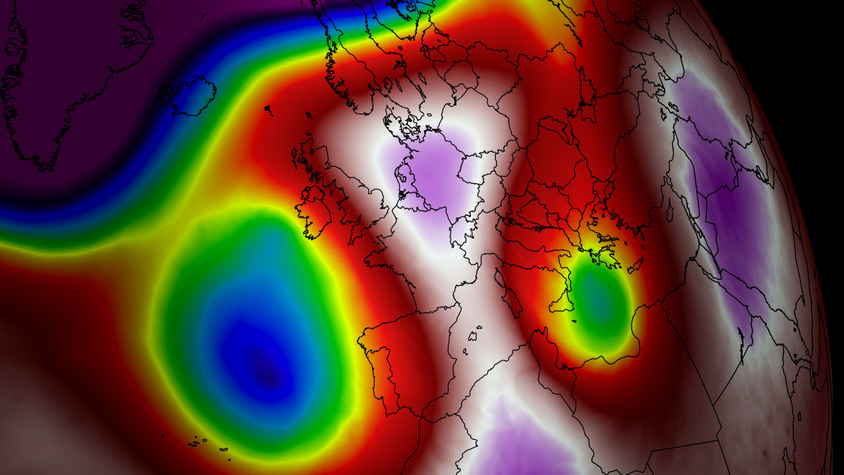
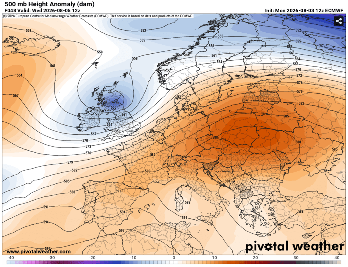
CENTRAL EUROPE — A formidable, high-amplitude upper-level ridge is aggressively expanding eastward across Central Europe and the Balkan Peninsula, locking in a prolonged and intense heatwave that is forecast to drive daytime highs above 40°C through the first week of August. Powered by a persistent heat dome synced with a stagnant Omega block pattern, an exceptionally warm and dry air mass continues to surge northward from North Africa.
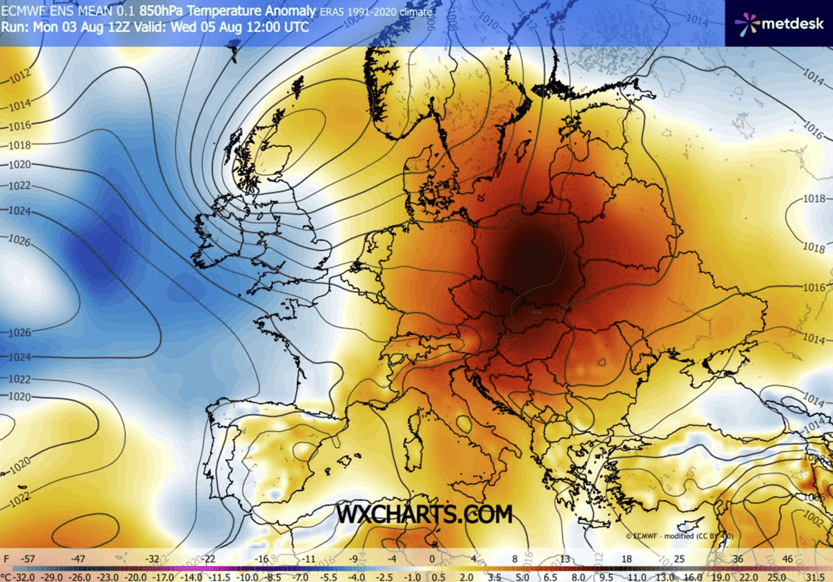
According to meteorological analyses, this weather setup is pushing upper-air thermal anomalies into the 99th percentile across northern Italy, Hungary, Croatia, Serbia, and surrounding regions. With low-lying river basins like the Po Valley and the Pannonian Basin bracing for surface temperatures ranging from 40°C to 43°C, public safety officials, agricultural sectors, and energy grids across the continent are being pushed to their absolute limits.

Main Facts: The Anatomy of the European Heat Dome
The driving engine behind this multi-week heat event is a stubborn, slow-moving high-pressure system parked directly over the heart of the European continent. As sinking air compresses and warms the lower troposphere, it acts like a lid on a pot, trapping exceptionally hot air at the surface and accelerating soil moisture loss through continuous continental dry winds.
- Temperature Extremes: Peak afternoon temperatures are widely forecasted to eclipse the 40°C threshold, with localized hot spots reaching up to 43°C in the Pannonian Basin and northern Italian plains.
- Tropical Nights: Nocturnal relief is virtually non-existent. Major urban centers are recording minimum overnight temperatures refusing to drop below 22°C to 26°C, compounding physiological strain on the human body.
- Geographical Spread: The heat dome’s core is shifting dynamically, initially impacting Central Europe (Germany, Czech Republic, Austria) before expanding eastward into the Balkans, Ukraine, and western Russia.
- Underlying Drivers: A combination of an Omega block pattern and northward-surging thermal anomalies from North Africa has locked the atmospheric pattern in place, preventing cooler maritime air from penetrating the affected regions.
Chronology of the Event: Day-by-Day Progression
Early Week: Central Europe Takes the Brunt
The initial phase of the extreme heat surge concentrated heavily over Western and Central Europe. On Tuesday, countries like Germany, the Czech Republic, and eastern Austria experienced severe heat, with daytime highs pushing 36°C to 38°C in Germany, up to 40°C in the Czech Republic, and severe spikes across the eastern Austrian plains.
While a western wave introduced cooler maritime air from the Atlantic into the United Kingdom, France, and the Iberian Peninsula—providing much-needed relief to Western Europe—it simultaneously acted as a wedge, forcing the upper-level ridge further east-southeast.
Mid-Week: Shift Toward Eastern Europe and the Balkans
By Wednesday and Thursday, the core of the heat dome elongated and repositioned eastward. The highest temperature anomalies shifted heavily toward Poland, Slovakia, Hungary, Croatia, northern Serbia, and western Romania.

Thursday marked the pinnacle of the heatwave for the northern Balkans and Eastern Europe, with valley temperatures consistently tracking between 38°C and 41°C, accompanied by suffocating tropical nights.
Late Week: Broadening Impact Across Southern and Eastern Flanks
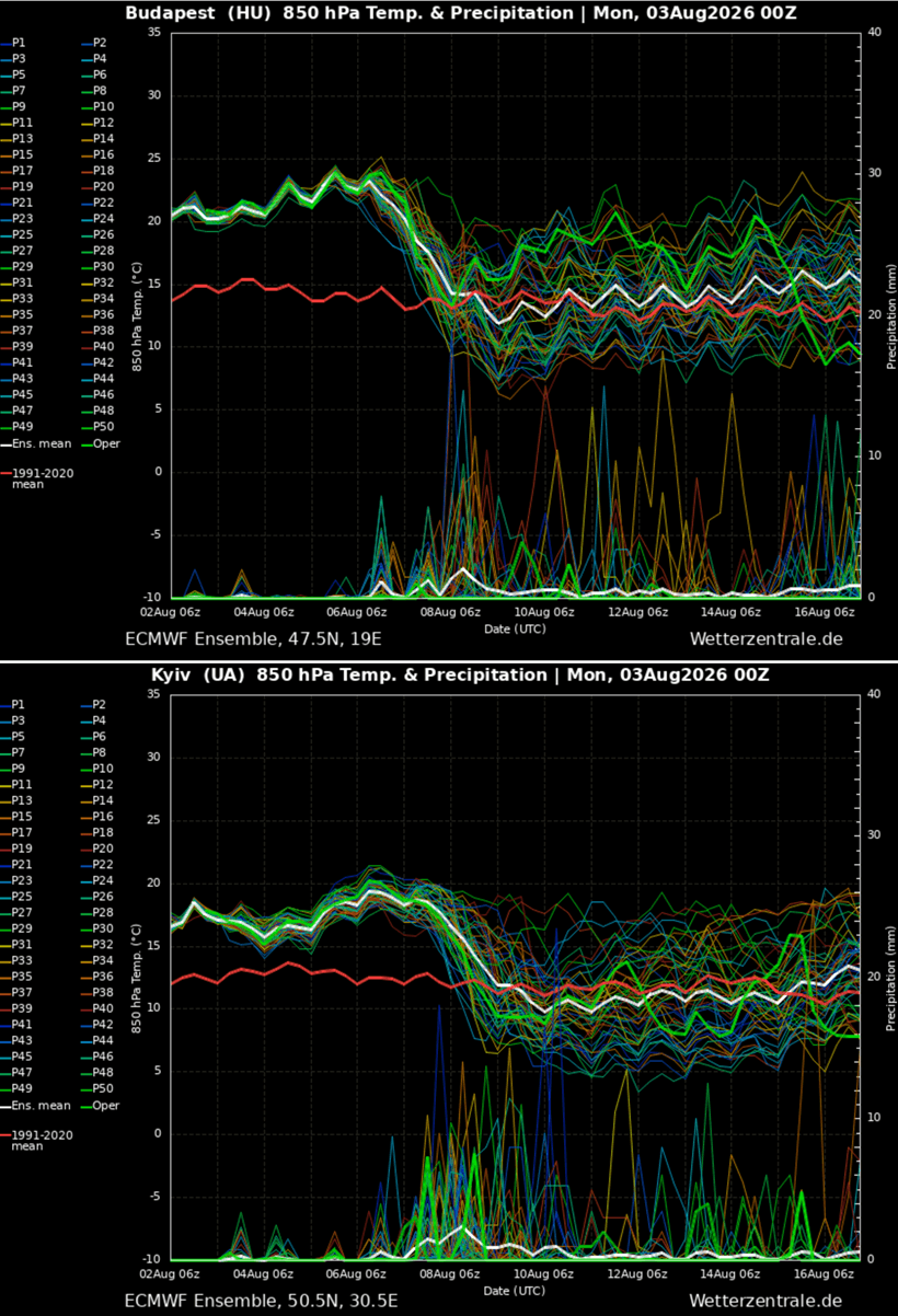
As the workweek concludes on Friday, the heatwave expands further south and east. Excessive heat warnings extend into Bulgaria, Greece, and western Russia. Meanwhile, mid-range ensemble models indicate that the current ridge over the Balkans will eventually collapse by the following weekend, making way for a potential new synoptic shift heading toward mid-August.
Supporting Data: Meteorological Mechanics and Indices
Understanding the severity of this heatwave requires looking beyond simple thermometer readings into upper-air dynamics and human biometeorology.
The Omega Block and 850 hPa Anomalies
At the 850 hPa isobaric surface (roughly 1,500 meters above sea level), thermal anomalies are registering in the 99th percentile. This means the air mass sitting above Central and Eastern Europe is statistically near-record-breaking for early August. The synoptic feature responsible—the Omega block—gets its name from its resemblance to the Greek letter $Omega$, where a high-pressure center is wedged between two low-pressure systems, freezing the weather pattern in place for days or weeks.
The Heat Index Factor
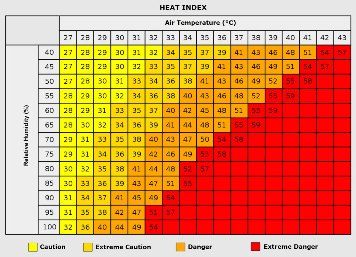
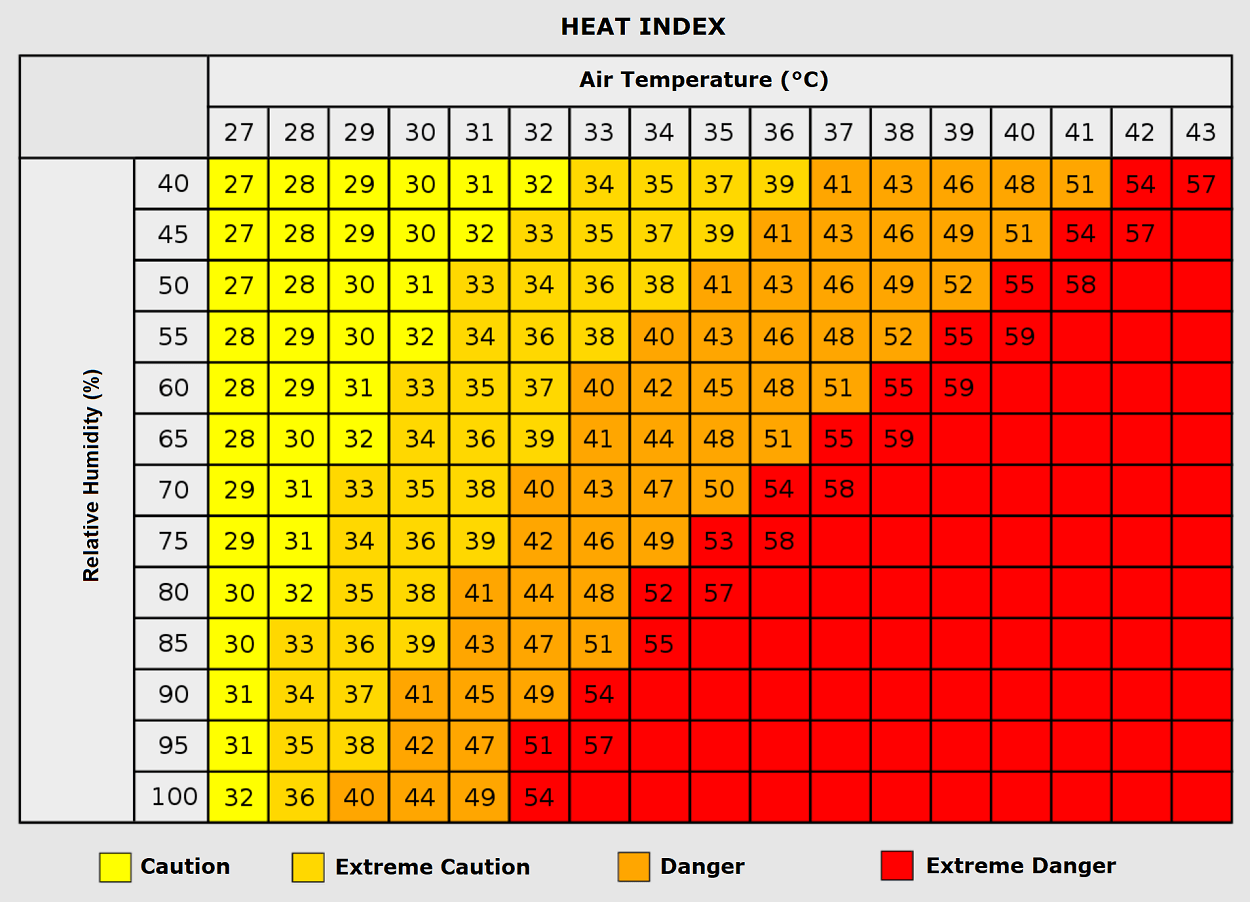
Humidity plays a critical role in how the human body experiences extreme heat. Meteorologists utilize the Heat Index to calculate the perceived temperature by combining ambient air temperature with relative humidity.
- At an air temperature of 35°C with moderate humidity (<60%), the human body can cool itself relatively efficiently through sweat evaporation.
- However, when high humidity accompanies temperatures above 35°C—or when ambient temperatures climb past 40°C with stagnant air—the heat index can make it feel like 50°C or higher.
This extreme thermodynamic environment dramatically spikes the physiological risk of heat exhaustion, heat stroke, acute cardiovascular events, and respiratory complications.
Official Responses and Societal Implications
The socio-economic and public health repercussions of a persistent heat dome of this magnitude are profound, triggering emergency responses across multiple nations.
Public Health and Vulnerable Populations
Health ministries across Italy, Hungary, Croatia, Serbia, and neighboring states have issued red-tier heat alerts. Public health officials emphasize that vulnerable populations—particularly the elderly, young children, and individuals with pre-existing cardiovascular or respiratory conditions—are at critical risk.
Furthermore, urban heat island effects exacerbate the crisis. Cities constructed largely of heat-trapping concrete, asphalt, and dense housing materials fail to radiate heat efficiently overnight, trapping residents in dangerous thermal pockets.
Occupational Hazards and Infrastructure Stress
- Outdoor Labor: Agricultural workers, construction crews, and delivery personnel face severe occupational hazards. Governments have mandated adjusted working hours, prohibiting heavy outdoor labor during peak afternoon radiation windows (typically 11:00 AM to 5:00 PM).
- Wildfire Preparedness: Prolonged dryness, combined with high winds and low soil moisture, has created explosive wildfire conditions across southern Europe and the western Balkans. Forestry and firefighting agencies remain on high alert for spontaneous ignitions and rapidly spreading brushfires.
- Energy Grids: Surging electricity demands, driven heavily by residential and commercial air conditioning use, are placing immense pressure on regional power grids. Utilities are monitoring transformer capacities closely to prevent widespread blackouts.
Future Outlook: A Potential Successor Heat Dome Next Week?
As meteorologists monitor the breakdown of the current atmospheric block over Eastern Europe, medium-range weather forecasting models are already signaling a concerning trend for the middle of August.
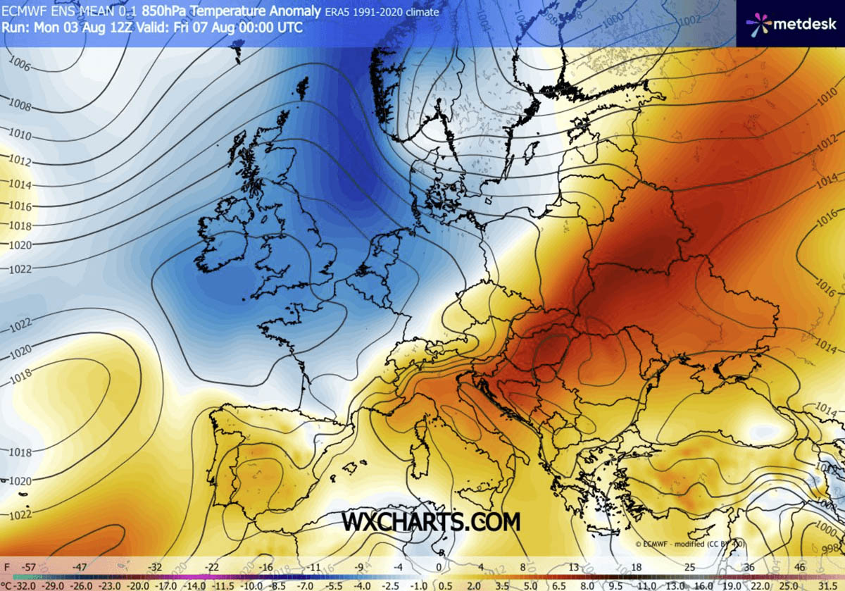
Ensemble model consensus suggests that a new high-pressure ridge could build aggressively across southwestern, western, and central Europe by next week. While exact geographical positioning remains subject to refinement as models project 10 days out, indications point toward a reforming heat dome that could bring a secondary significant heatwave to Portugal, Spain, France, the Alps, and eventually parts of the British Isles.
Meteorological agencies and forecasters will continue to track these evolving patterns, urging populations in the path of these anomalies to heed local advisories and prepare for an exceptionally volatile summer climate regime.
