

Main Facts
A high-amplitude, persistent upper-level ridge has locked a massive and suffocating Heat Dome across the United States and parts of Canada, driving peak afternoon temperatures well past 105°F to 110°F. Extending from the desert Southwest and central plains into early August, the extreme heat event is fueled by deep atmospheric compression and upper-air thermal anomalies sitting firmly in the 99th percentile.
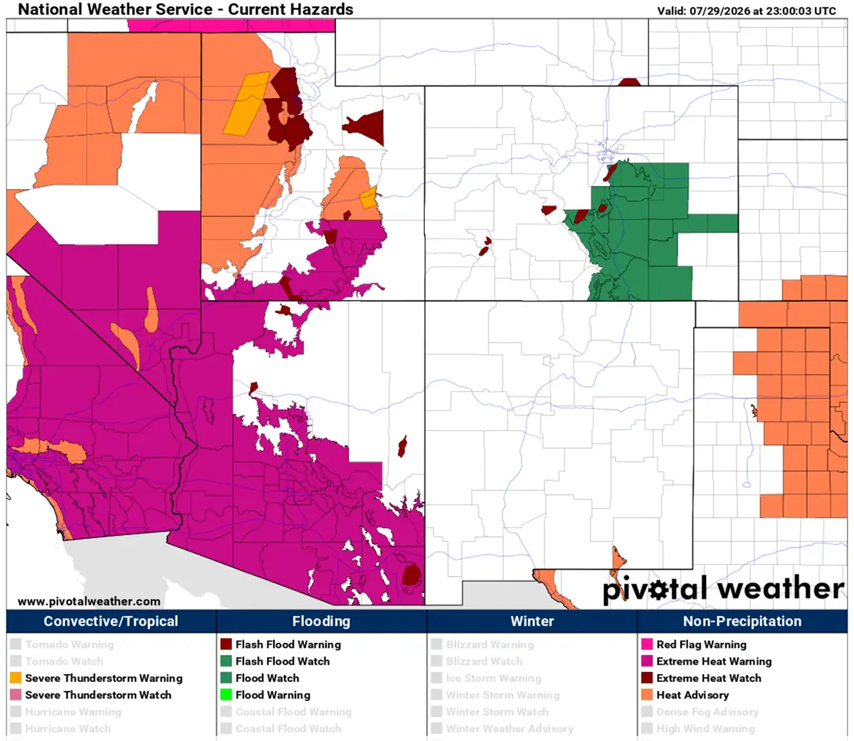
The multi-week weather anomaly is stretching dangerously high heat indices across a vast swath of the continent—reaching from Southern California and the Great Basin, across the Great Plains, and as far east as the Mississippi Valley. Desert basins are bearing the brunt of the meteorological punishment, with peak daytime highs forecasted to soar between 115°F and 120°F. Compounding the physiological stress, overnight low temperatures are refusing to drop, hovering stubbornly between 75°F and 80°F in major urban corridors.
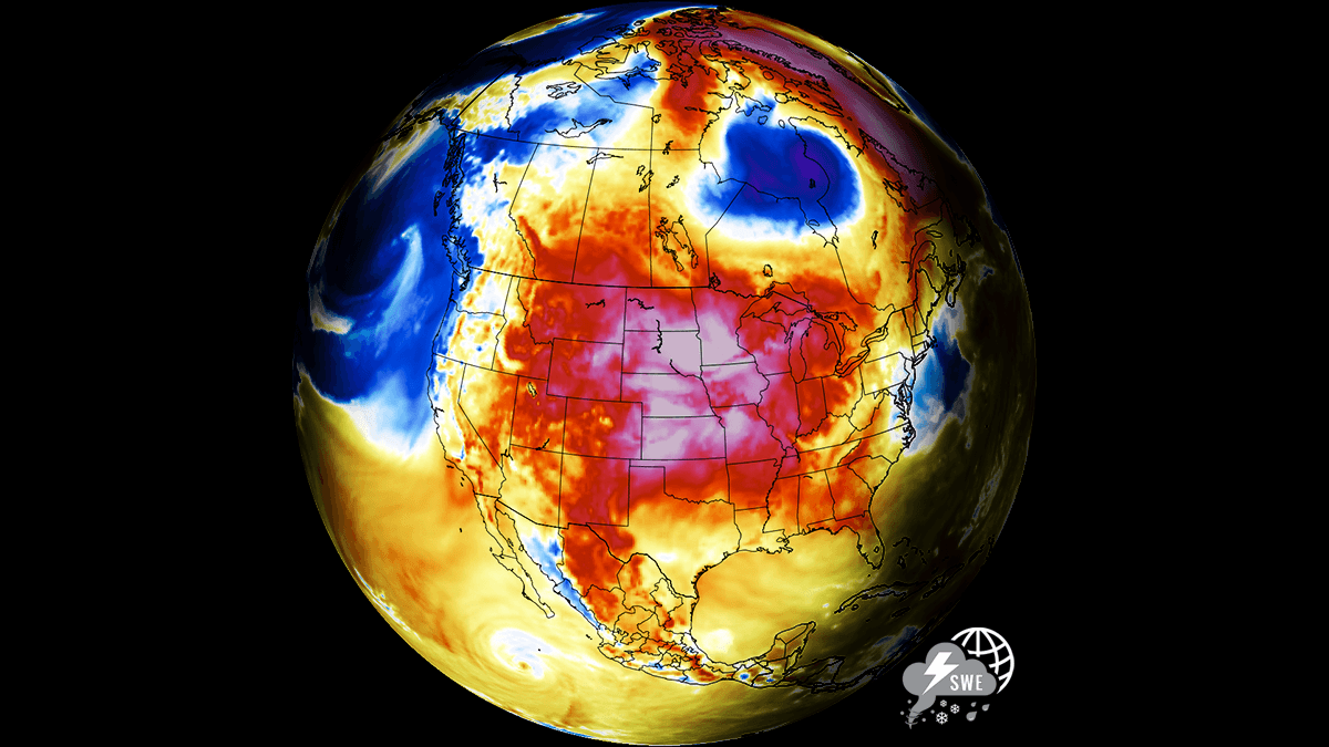
This lack of nocturnal cooling is robbing vulnerable populations of crucial physiological recovery time, triggering exponential spikes in power grid demand, and rapidly accelerating soil moisture depletion across major North American agricultural belts. Global weather modeling from sources like PivotalWeather and WXcharts indicates that the high-pressure system is behaving like an atmospheric lid, trapping heat at lower elevations and causing descending air masses to compress and superheat near the surface.
Synoptic Setup and Atmospheric Dynamics
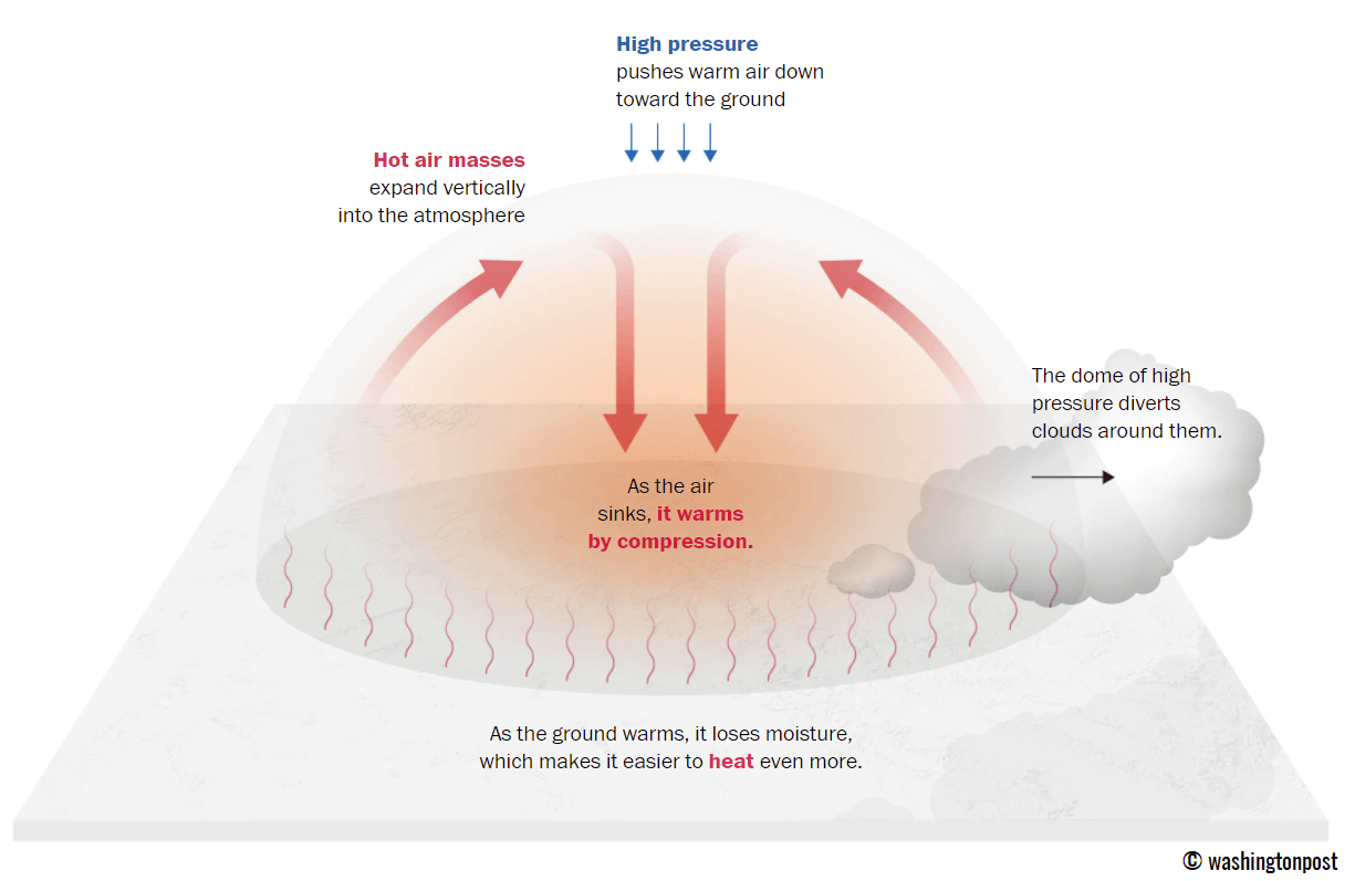
How High-Pressure Heat Domes Compress and Trap Air
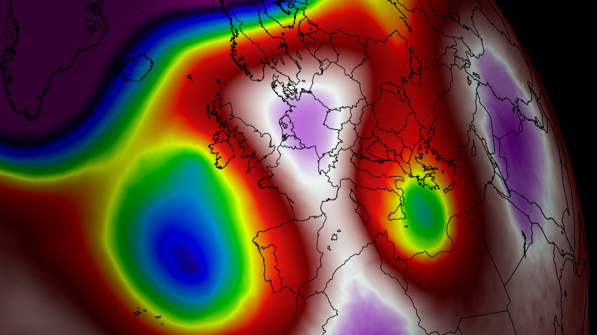
Meteorologists describe the driving mechanism behind this event as an upper-level ridge or "blocking high." Historically, similar high-pressure heat domes have been the primary architects of record-shattering summer heatwaves across North America and Europe.
When a broad area of high-pressure air parks itself over a large portion of the continent for an extended period, it establishes a remarkably stable atmospheric block. This dome functions precisely like a lid on a pot of boiling water. It traps warm air at all levels underneath it, forcing atmospheric layers to sink progressively closer to the ground. As the air descends, it undergoes adiabatic compression, causing it to warm significantly. This process results in anomalously warm air masses at lower elevations and blistering, potentially lethal heat near the Earth’s surface.
The Synoptic Progression: Western and Central U.S. Alignment
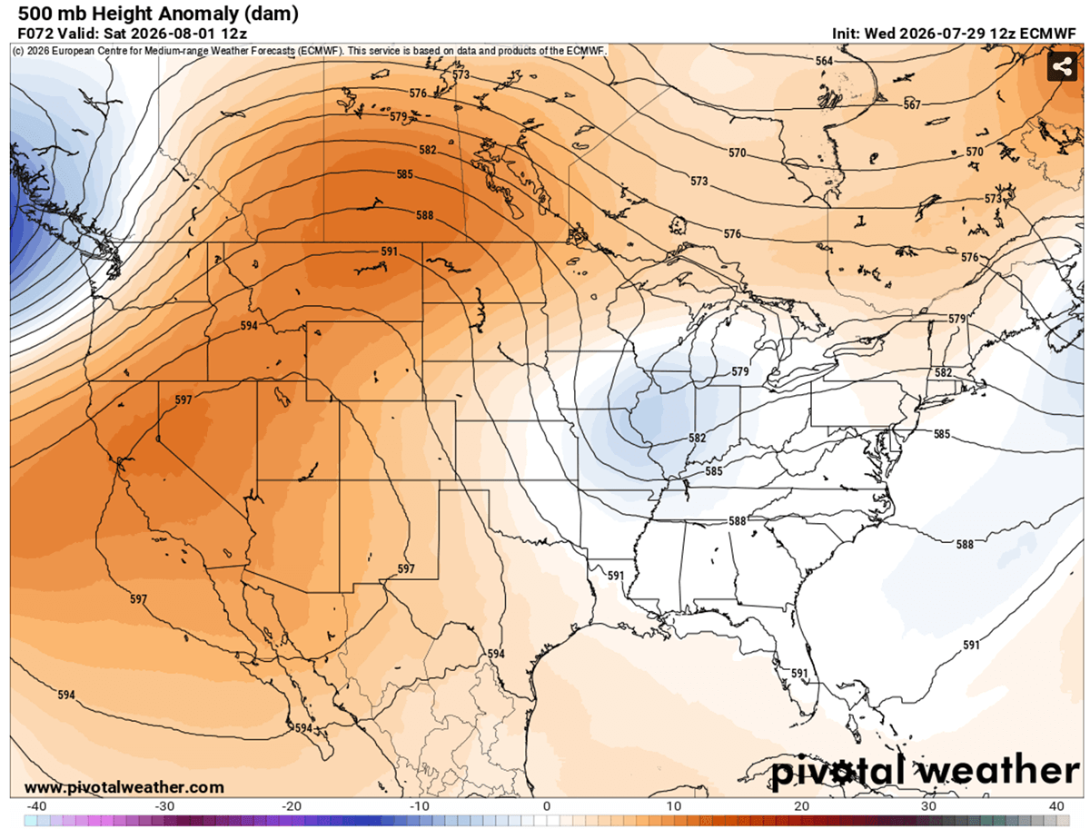
The overarching synoptic pattern features a powerful upper-level ridge anchored over the Western United States, the Northern Rockies, and extending northward into southern Canadian provinces such as Alberta and Saskatchewan. To the east of this massive thermal ridge, a shallow low-pressure system is tracking eastward from the mid-Mississippi Valley toward the Southeast U.S.
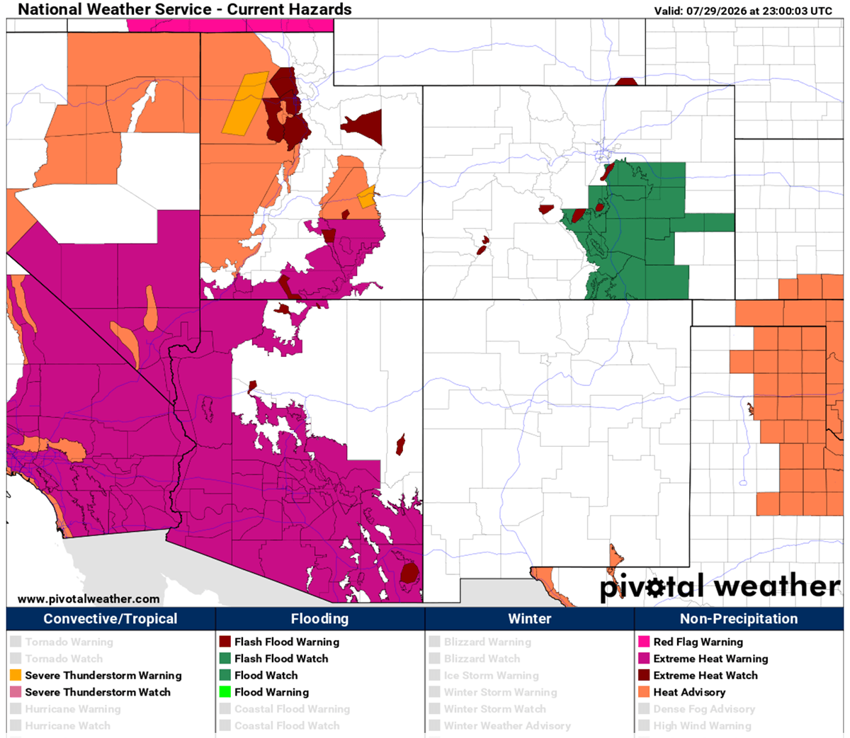
The core of the heat dome aloft spans a massive geographic footprint, covering California, Arizona, Nevada, Utah, Idaho, Wyoming, and Montana. Underneath this atmospheric vault, subsiding air is translating into rapidly climbing surface temperatures. Regions that began the week seeing daytime highs in the mid-90s to near 100°F are witnessing continuous amplification as the dome traps additional thermal energy, pushing afternoon peaks toward 105°F and beyond.
Chronology of the Extreme Heat Event
Mid-Week Buildup: Thursday and Friday
As the upper-level ridge intensified through the middle of the week, surface temperatures across the Great Plains climbed steadily into the upper 90s and hovered near 103°F. The most aggressive early-stage values were concentrated from Texas northward through Oklahoma and Kansas, where afternoon readings breached the low 100s.
Weekend Peak: Saturday and Sunday
The heat dome reached maximum intensity over the weekend, particularly across Montana, Wyoming, and the western Dakotas, where the upper-level dome established its strongest footprint. Saturday afternoon peaks in these regions surged from 103°F to nearly 110°F. Meanwhile, the desert Southwest continued to bake under unforgiving sunshine, with valley floors recording blistering daytime highs between 112°F and 120°F.
Sunday maintained the relentless trend. The Plains—stretching from Texas all the way to the Dakotas—experienced widespread afternoon temperatures ranging from the upper 90s to low 100s. Concurrently, Arizona, Nevada, and California remained trapped beneath persistent thermal maximums of 115°F to 120°F.
Early Next Week Transition: Monday and Beyond
By Monday, the core of the hottest air mass is forecast to shift slightly, focusing its intensity across the central and southern Plains. Peak temperatures of 100°F to 105°F are projected for New Mexico, Texas, and the Colorado High Plains.
Looking ahead past the weekend and into the early days of August, global weather models hint at a forthcoming pattern shift. A cold frontal system descending from Canada is expected to track eastward, introducing cooler air masses to the northern High Plains by Wednesday and finally offering some relief from the prolonged siege.
Supporting Data and Meteorological Observations
- Temperature Anomalies: Upper-air thermal anomalies (measured at the 850 hPa level) are currently tracking in the 99th percentile, illustrating the rarity and statistical extremity of the air mass.
- Peak Daytime Highs:
- Desert Southwest and low-lying valleys: 115°F to 120°F.
- Northern High Plains, Montana, Wyoming, and the Dakotas: 103°F to 110°F.
- Great Plains and Texas to Kansas corridor: 100°F to 105°F+.
- Overnight Lows: Urban centers are experiencing minimum temperatures stuck between 75°F and 80°F, eliminating natural nighttime cooling relief.
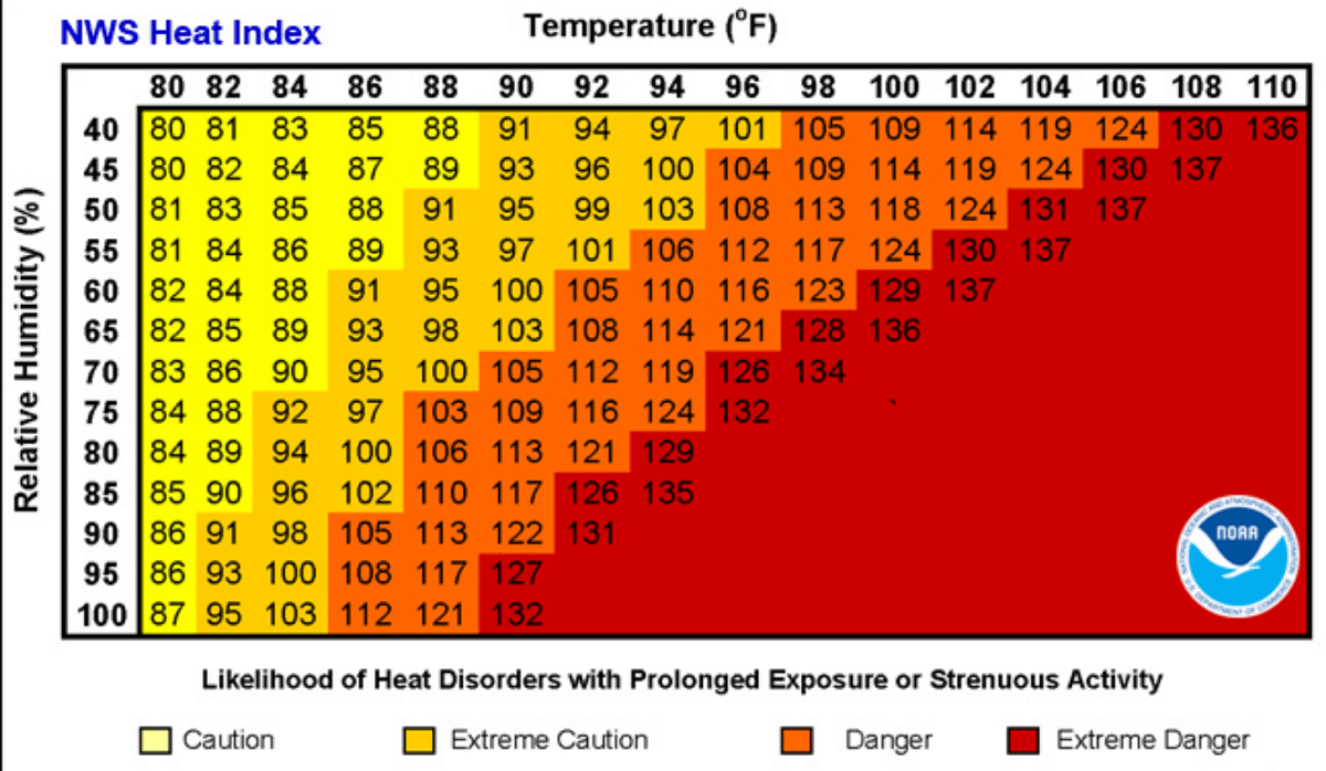
- The Heat Index Factor: Relative humidity combined with high ambient temperatures is driving perceived "feels-like" temperatures to dangerous extremes. For instance, an air mass with a temperature of 90°F paired with humidity exceeding 80% can easily produce a perceived heat index value surging past 113°F, dramatically increasing the risk of rapid physiological breakdown.
Official Responses and Public Health Warnings
Public health officials, municipal emergency management agencies, and national weather services have issued widespread excessive heat warnings, watches, and advisories across more than a dozen states.
Vulnerable Populations at Risk
Medical professionals emphasize that extreme heatwaves of this magnitude pose immediate, life-threatening risks to vulnerable demographics. Elderly individuals, young children, and people with pre-existing cardiovascular or respiratory conditions are uniquely susceptible to heat-related illnesses.
Furthermore, socioeconomic disparities play a critical role in heat vulnerability. Populations residing in lower-income urban neighborhoods often live in environments characterized by "urban heat islands"—areas heavily saturated with heat-retaining building materials like concrete, asphalt, and asbestos, coupled with a lack of green canopy spaces. These homes frequently lack adequate, functioning air conditioning, turning residences into thermal traps during multi-week high-pressure events.
Occupational Hazards
Outdoor laborers—including agricultural workers, construction crews, and delivery personnel—face extreme occupational hazards. Prolonged exertion in high-temperature, high-humidity environments rapidly depletes the body’s cooling mechanisms.
- Heat Exhaustion: Characterized by heavy sweating, weakness, dizziness, nausea, and a weak pulse. If ignored, it can quickly escalate into a medical emergency.
- Heat Stroke: A life-threatening condition where the body’s internal temperature skyrockets, sweating stops, and neurological symptoms such as confusion, fainting, or seizures occur, requiring immediate emergency intervention.
Beyond direct thermoregulatory failure, extensive epidemiological data linked to prolonged heat domes shows statistically significant spikes in secondary medical emergencies, including a heightened incidence of heart attacks, strokes, and acute respiratory distress.
Implications: Infrastructure, Agriculture, and the Energy Grid
Power Grid Strain
The persistence of high diurnal temperatures coupled with elevated overnight lows has driven electricity demand to near-record levels. Households and businesses are running air conditioning units continuously, denying the power grid its traditional overnight window to perform maintenance and cool transmission infrastructure. Grid operators across the Southwest and central plains have urged consumers to practice voluntary energy conservation during peak afternoon and evening hours to prevent rolling brownouts or catastrophic grid failures.
Agricultural and Environmental Impacts
The multi-week duration of the heat dome is taking a severe toll on the agricultural sector. Rapidly accelerating soil moisture depletion, driven by intense surface evaporation and lack of precipitation under the sinking air of the high-pressure ridge, is placing stress on staple crops across the major grain and agricultural belts of the U.S. and Canadian plains. Dry soils further exacerbate local warming trends through a feedback loop, as dry ground heats up much faster than moist soil, intensifying afternoon surface temperatures even further.
As meteorologists continue to monitor the progression of the upper-level ridge and the impending Canadian cold front, authorities urge residents within the affected zones to stay tuned to local forecasts, limit strenuous outdoor activities, utilize designated cooling centers, and check frequently on elderly neighbors and family members.
