

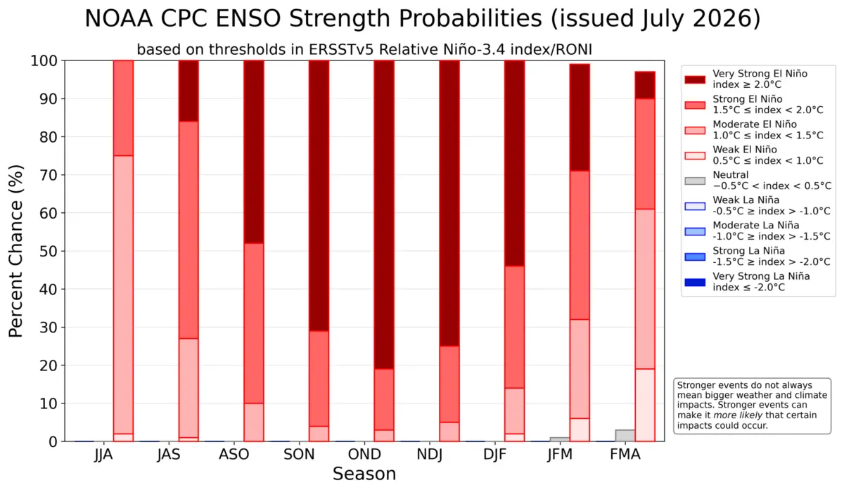
August 26, 2026 — Atmospheric scientists and long-range forecasters are tracking the rapid emergence of a powerful Super El Niño across the tropical Pacific. Current oceanographic analyses and global meteorological models indicate that this climate driver is accelerating faster than most historical benchmarks.
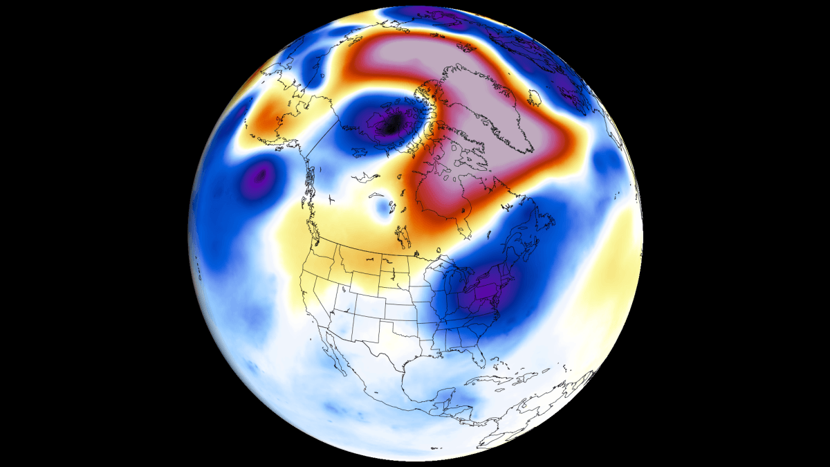
With sea-surface temperature anomalies tracking toward unprecedented territory for late fall and winter, the global atmosphere is already responding. A broad circulation framework—often called an atmospheric bridge—is locking into place, threatening to reshape seasonal weather patterns across the United States, Canada, and Europe well ahead of schedule.
Main Facts: The Anatomy of a Super El Niño
The 2026/2027 El Niño event is characterized by several key meteorological indicators:
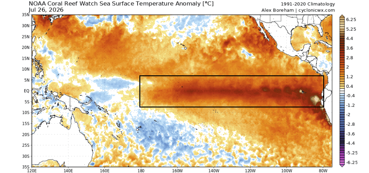
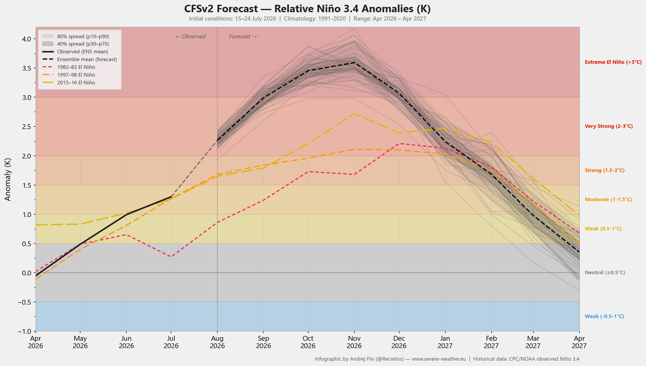
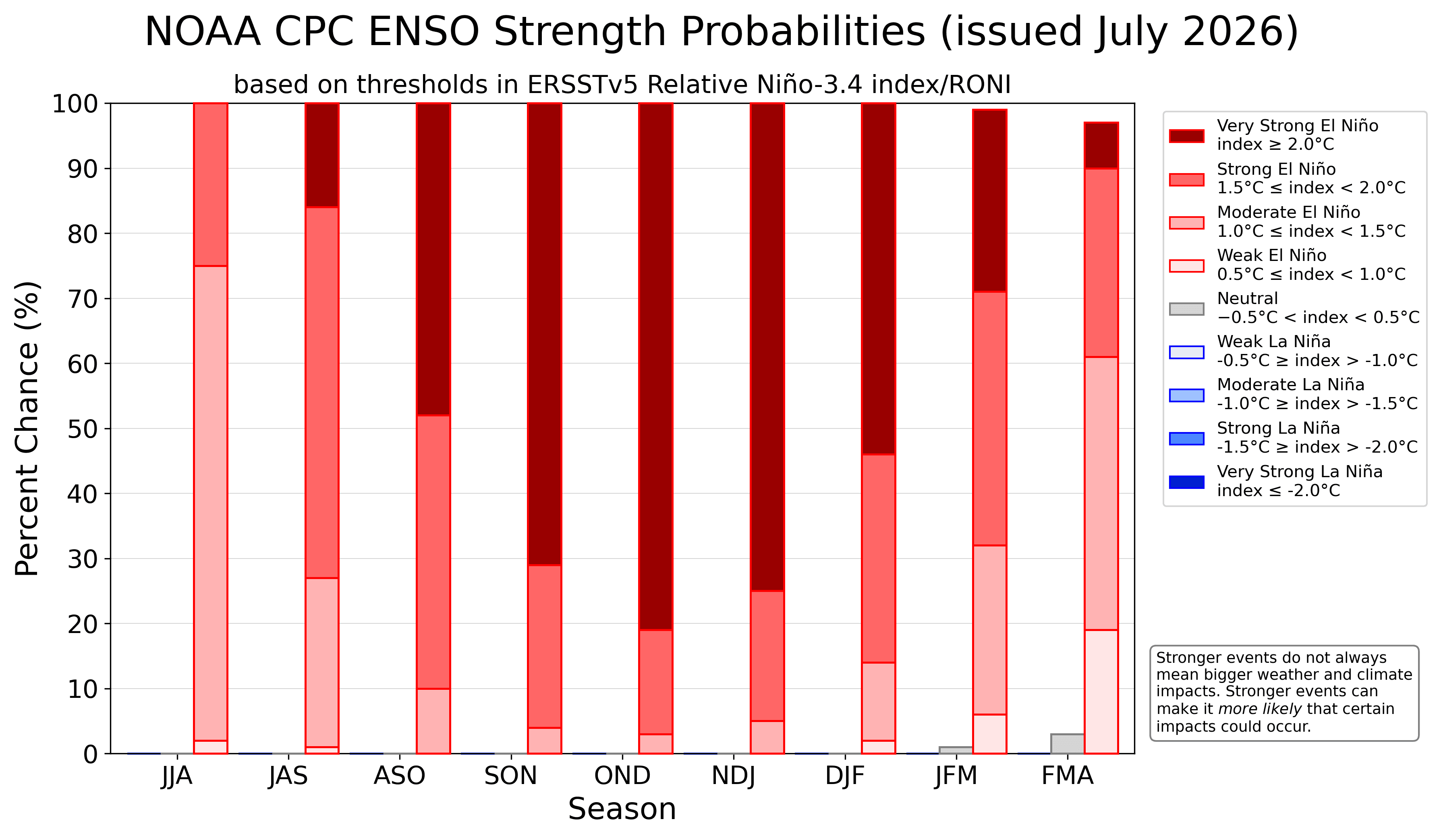
- Record-Breaking Intensification: Ocean temperature anomalies in the central and eastern equatorial Pacific are projected to exceed the +3°C to +5°C threshold above normal, blowing past the traditional +2°C criteria required for a "Super" classification.
- Kelvin Wave Propulsion: Subsurface warming, driven by powerful westerly wind bursts, has generated a massive Kelvin Wave propagating upward and eastward, supercharging surface temperature anomalies.
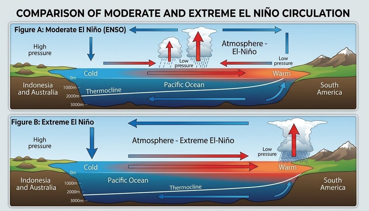
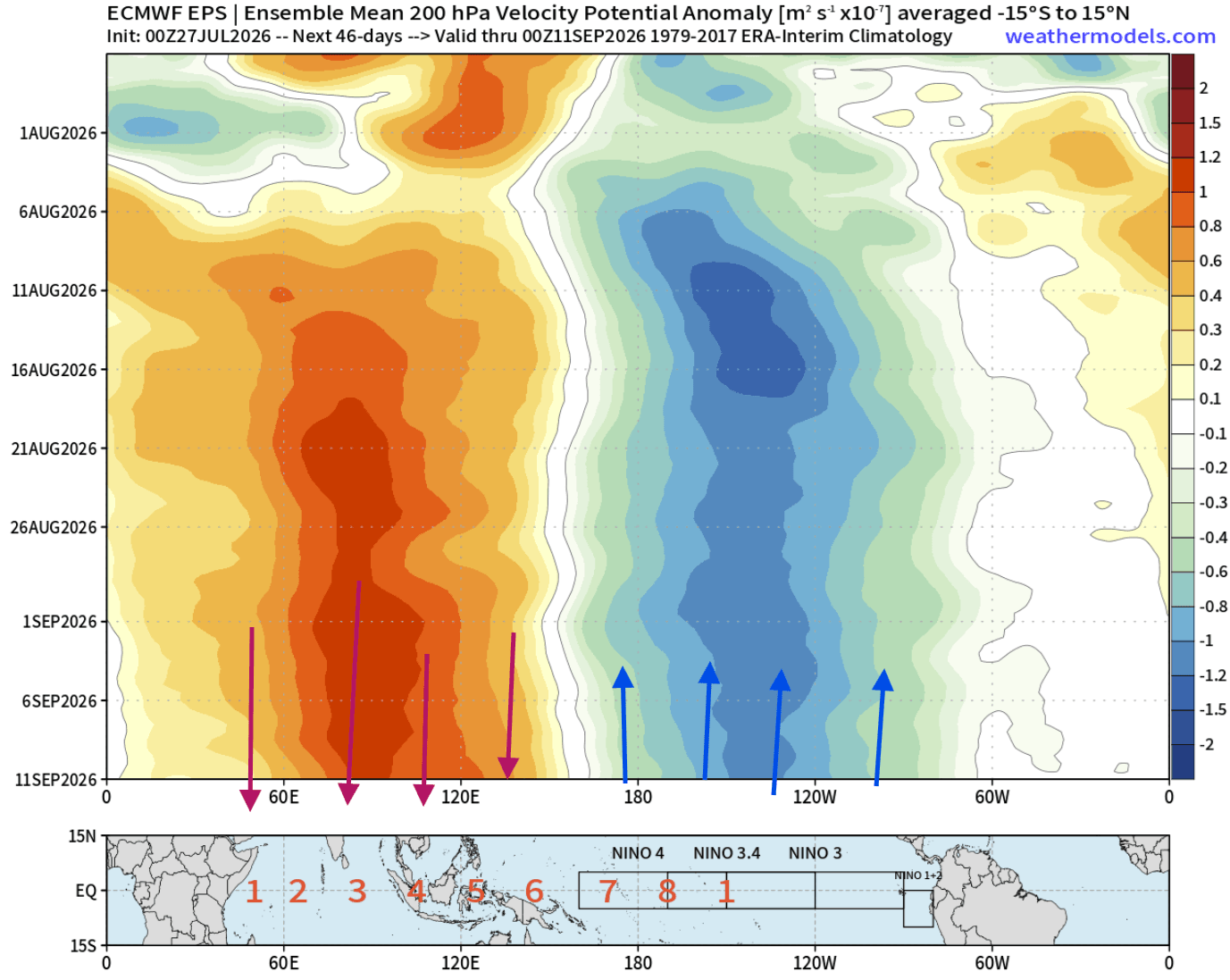
- Atmospheric Standing Wave: A permanent region of low pressure and rising air has anchored over the tropical Pacific, severely modifying global Walker Circulation and fundamentally altering the mid-latitude jet stream.
- The North American Divide: High-pressure ridging across northern latitudes will block deep Arctic air early on, while an aggressive, moisture-laden southern jet stream directs active storm tracks across the southern United States.
- Winter-Like Fall Transitions: Due to the sheer magnitude of the oceanic forcing, classic mid-winter pressure setups are appearing as early as autumn, dictating a volatile split-flow regime for late 2026 and early 2027.
Chronology of Development: From Summer Signals to Winter Realities
July 2026: The Initial Atmospheric Footprint
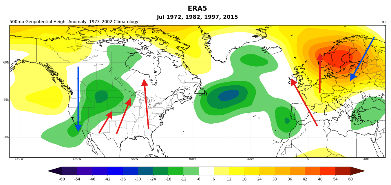
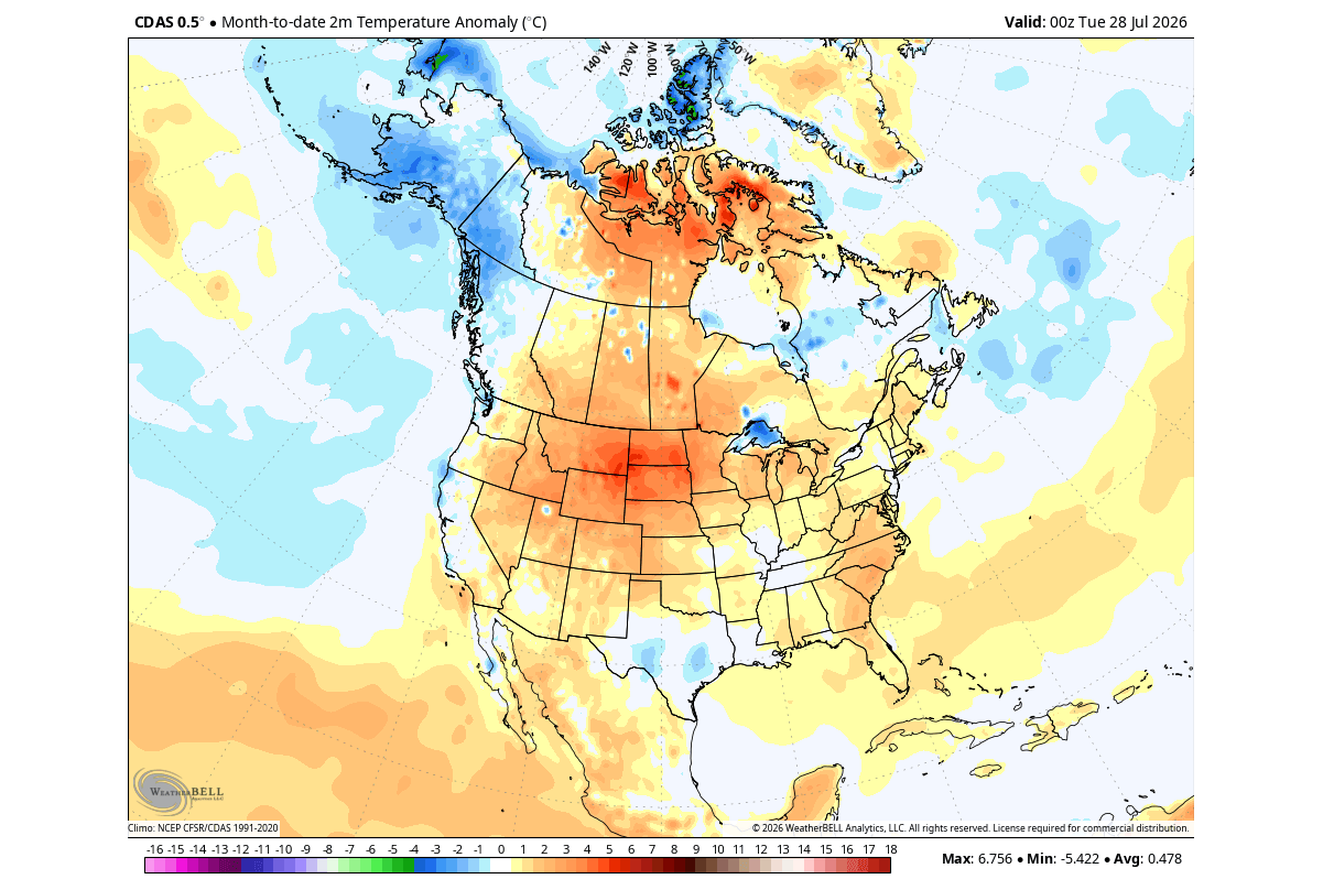
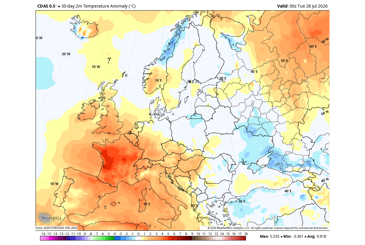
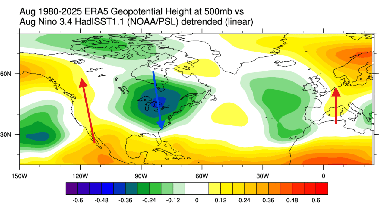
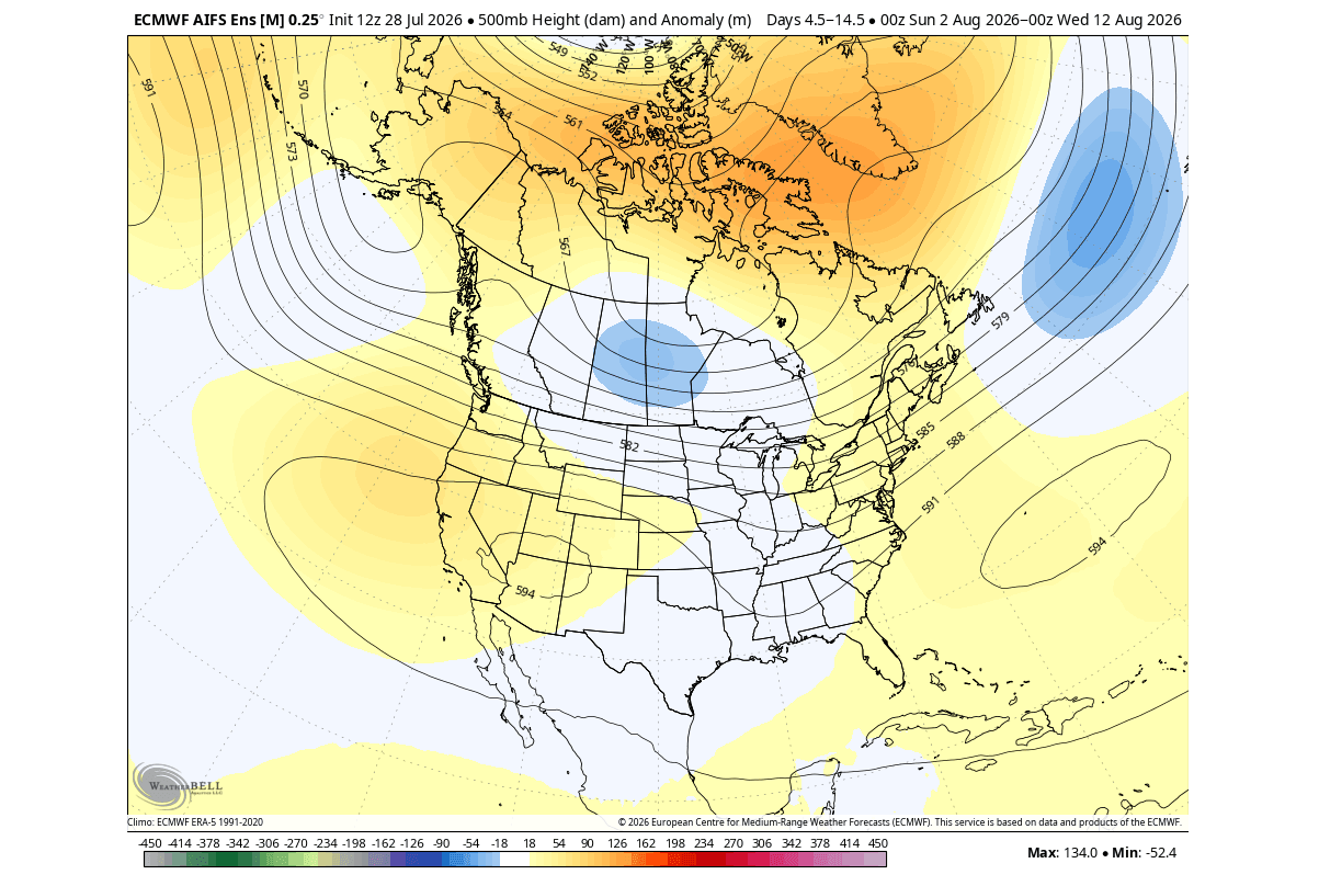
As July drew to a close, pressure and temperature patterns across North America and Europe mirrored historical Super El Niño markers. A western low-pressure anomaly over North America induced a warm southerly flow under a high-pressure ridge across the central and eastern U.S. and Canada, while the West Coast experienced cooler, marine-influenced conditions.
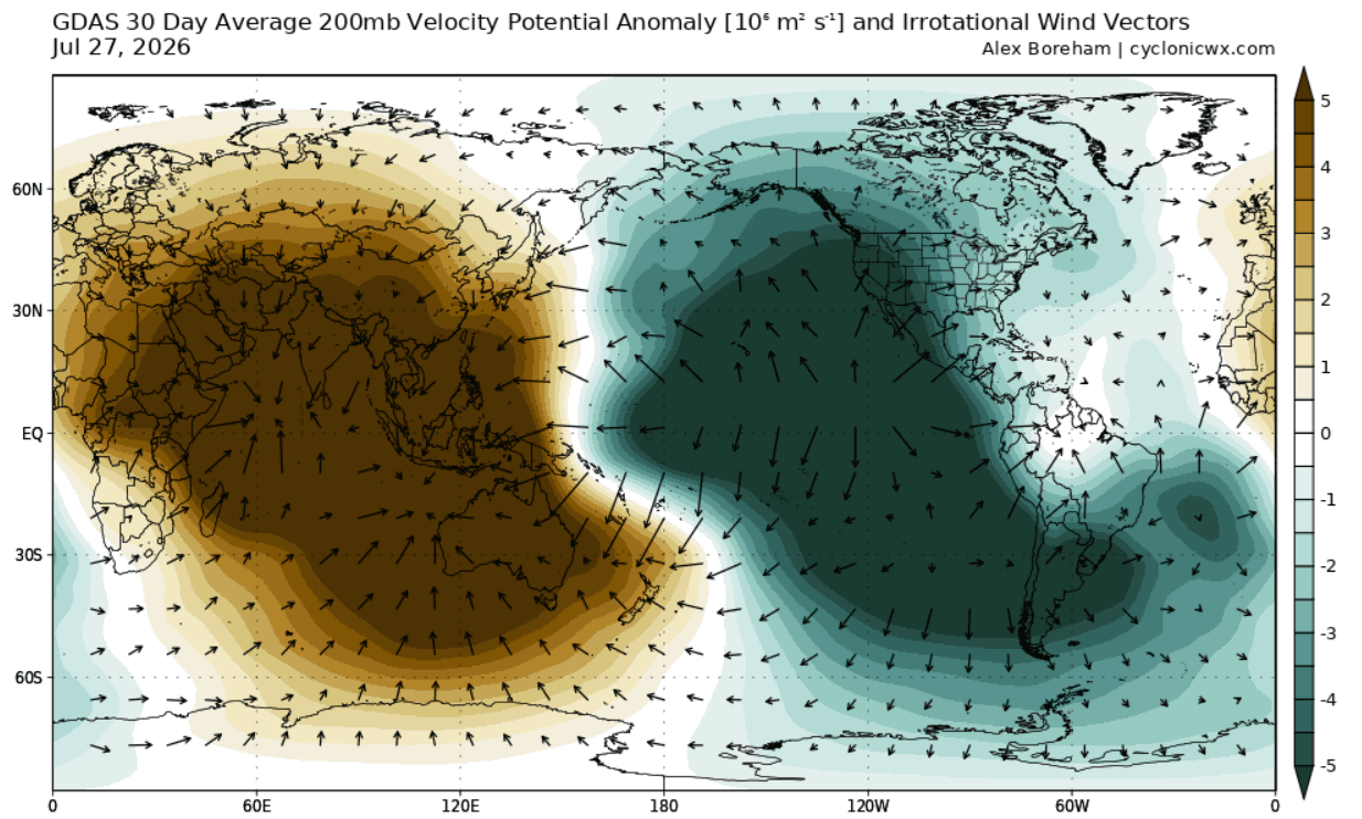
Simultaneously, velocity potential anomalies at the 200mb level (approximately 12 kilometers high) confirmed a heavily modified Walker Cell. Strong rising air motion dominated the central and eastern Pacific, while sinking air prevailed over the Indian Ocean, cementing the presence of an active atmospheric bridge.
August 2026: Pacific Locking and the Jet Stream Shift
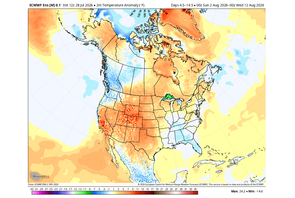
Entering August, ECMWF ensemble forecasts highlighted a persistent "standing wave" over the Pacific. While the month began with localized variations—including a cooler eastern U.S. temperature anomaly during the first ten days—mid-to-late August trends quickly realigned with classical El Niño parameters.
A low-pressure trough began establishing itself over the eastern United States and Canada, driving below-normal temperature trends into the Midwest and Northeast. Meanwhile, a strong subtropical jet stream began flexing its muscles, setting the stage for major autumn amplification.
Supporting Data: Modeling the Extreme Phase
Meteorological modeling from leading agencies—including the NOAA Climate Prediction Center (CPC), NCEP CFSv2, and the European Centre for Medium-Range Weather Forecasts (ECMWF)—demonstrates a high-confidence consensus regarding the event’s intensity.
[Equatorial Pacific Subsurface Warming]
       │
       ▼ (Driven by Westerly Wind Bursts)
[Massive Kelvin Wave Propagation]
       │
       ▼ (Surface Emergence)
[Extreme Super El Niño (>+3°C Anomaly)]
       │
       ▼
[Modified Walker Circulation & Atmospheric Standing Wave]
       │
       ├─────────────────────────────────┐
       ▼                                 ▼
[North American Split-Flow]       [European Low-Pressure Resistance]
Central vs. Eastern Pacific (CP vs. EP) Dynamics
Research indicates that the location of peak ocean warming dictates how effectively an El Niño bends the jet stream. The NMME forecast for the October–December period classifies the 2026 event as a potent Eastern Pacific (EP) event.
While Central Pacific events often deliver a more direct wave impact, the sheer magnitude of the 2026 EP anomaly—peaking above +4°C in the core ENSO regions—compensates for its geographic placement. This raw thermal energy forces extreme upper-level atmospheric adjustments, bypassing the more sluggish behavior typically seen in moderate events.
Official Responses and Outlooks
North American Winter 2026/2027 Outlook
NOAA’s next-generation SFS model and ECMWF seasonal guidance point toward a distinct split-flow pattern for the upcoming winter:
- The Northern Tier: A robust high-pressure blocking pattern over Canada will largely suppress deep Arctic air intrusions. This setup diminishes seasonal snowfall potential across the Northern Plains, upper Midwest, and Great Lakes, favoring milder, drier conditions.
- The Southern Tier: The active storm track is displaced aggressively southward. The Central and Southern Plains, Gulf Coast, and the interior Mid-Atlantic face an elevated risk of heavy winter storms, frequent precipitation, and moisture-rich low-pressure systems.
- Temperature Evolution: January will introduce a distinct cooling footprint across the Southern Plains and Gulf Coast. By February, this cooling anomaly is projected to deepen and expand, enveloping large portions of the Central, Eastern, and Southern United States in frequent cold air intrusions.
The European Perspective
Europe continues to experience a delayed and more complex response to the Pacific forcing. Early-month August forecasts featured a resistant low-pressure anomaly over northern Europe rather than the classic high-pressure blocking ridge, resulting in mixed temperature profiles and localized heavy rainfall.
As the season progresses into Fall, a westerly and southwesterly flow from Atlantic low-pressure systems is projected to introduce above-normal Autumn rainfall across much of the continent, with mild, above-normal surface temperatures focused heavily over central and western regions. True El Niño-driven continental impacts for Europe remain tied to the eventual winter peak of the anomaly.
Implications for Agriculture, Infrastructure, and Public Safety
The rapid development of a record-intensity Super El Niño carries significant socio-economic and environmental implications:
- Agricultural Disruptions: The North American weather divide will test farming regions. While northern and central grain belts may face moisture deficits or unseasonable warmth, the southern tier must prepare for excessive soil saturation, flood risks, and delayed planting or harvesting schedules driven by relentless storm tracks.
- Infrastructure Strain: Southern municipalities unaccustomed to frequent winter storm cycles may experience transportation gridlock, power grid vulnerabilities, and severe urban flooding. Conversely, northern regions relying on winter tourism and snowpack accumulation may face severe economic headwinds due to abnormally low snowfall totals.
- Global Weather Volatility: As the atmospheric bridge matures, emergency management agencies worldwide are advised to monitor weekly updates. The transition from late summer variability into an amplified winter regime highlights the necessity of adaptive climate preparedness in an era of intensifying global weather anomalies.
