

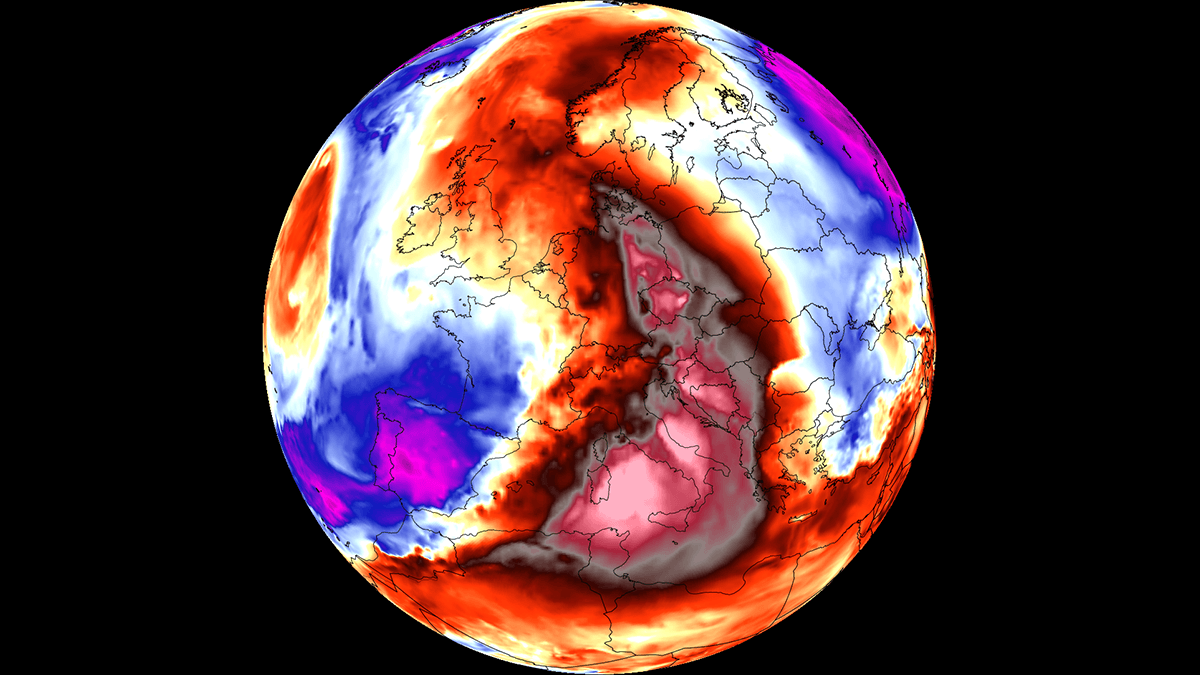
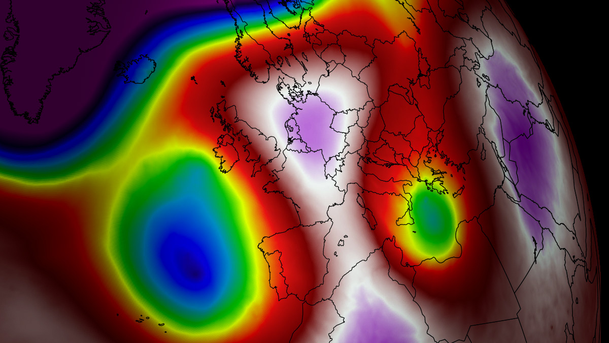
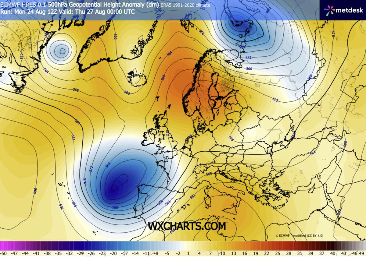
EUROPE — As the summer of 2026 enters its final stretch, the European continent is confronting yet another meteorological ordeal. A stubborn, highly potent blocking high-pressure system has locked over the Central Mediterranean and Southern Europe, spawning the sixth powerful "heat dome" of the season.
With surface temperatures forecast to surge between 38°C and 43°C across low-lying river basins and agricultural plains, meteorologists warn that this late-season thermal event is not merely a passing warm spell. Rather, it represents an intense, physiologically taxing weather anomaly driven by deep atmospheric compression. While Southern and Central Europe swelter under blistering daytime highs and suffocating "tropical nights," the extreme thermal gradient is simultaneously setting the stage for a violent severe thunderstorm outbreak across France and the western Alps.
Main Facts
- The Phenomenon: The sixth major heat dome of the 2026 season has established a powerful upper-level ridge across the Central Mediterranean and Southern Europe, drawing unseasonably hot air masses northward from North Africa.
- Peak Temperatures: Daytime highs are projected to reach between 38°C and 43°C (100°F–109°F) in vulnerable low-lying river basins, valleys, and plains, sitting 12°C to 16°C above the long-term seasonal averages for late August.
- Nocturnal Stress: Major urban corridors are experiencing dangerous "tropical nights," where overnight lows refuse to drop below 22°C to 26°C, denying human populations any meaningful physiological recovery and heavily straining regional energy grids.
- Atmospheric Mechanics: The heat dome acts as an atmospheric lid. Sinking air adiabatically compresses and warms the lower troposphere, trapping heat at the surface while dry continental winds accelerate soil moisture depletion and amplify wildfire risks.
- The Flip Side (Severe Storms): The sharp temperature and pressure gradient between the Mediterranean heat dome and a deep Atlantic trough over the Bay of Biscay is fueling extreme atmospheric instability. This dynamic threatens a violent severe weather outbreak—including destructive supercells, giant hail, and possible tornadoes—across France and the western Alps.
Chronology: Evolution of the Late-August 2026 Heat Dome
The development of this late-season weather extremes follows a distinct synoptic progression across the continent, moving from initial high-pressure buildup to an eventual eastward shift by the weekend.
Mid-Week Buildup: The North African Plume Surges North
By Wednesday and Thursday, a robust upper-level ridge originating over North Africa pushed aggressively across the Mediterranean Basin. Bolstered by an unseasonably deep upper trough parked over the Bay of Biscay and western Iberia, the ridge expanded rapidly northward. This dynamic forced warm air plumes across the Alps into parts of Germany and Central Europe, where localized temperatures climbed into the mid-30s.
Peak Intensity: Thursday through Saturday
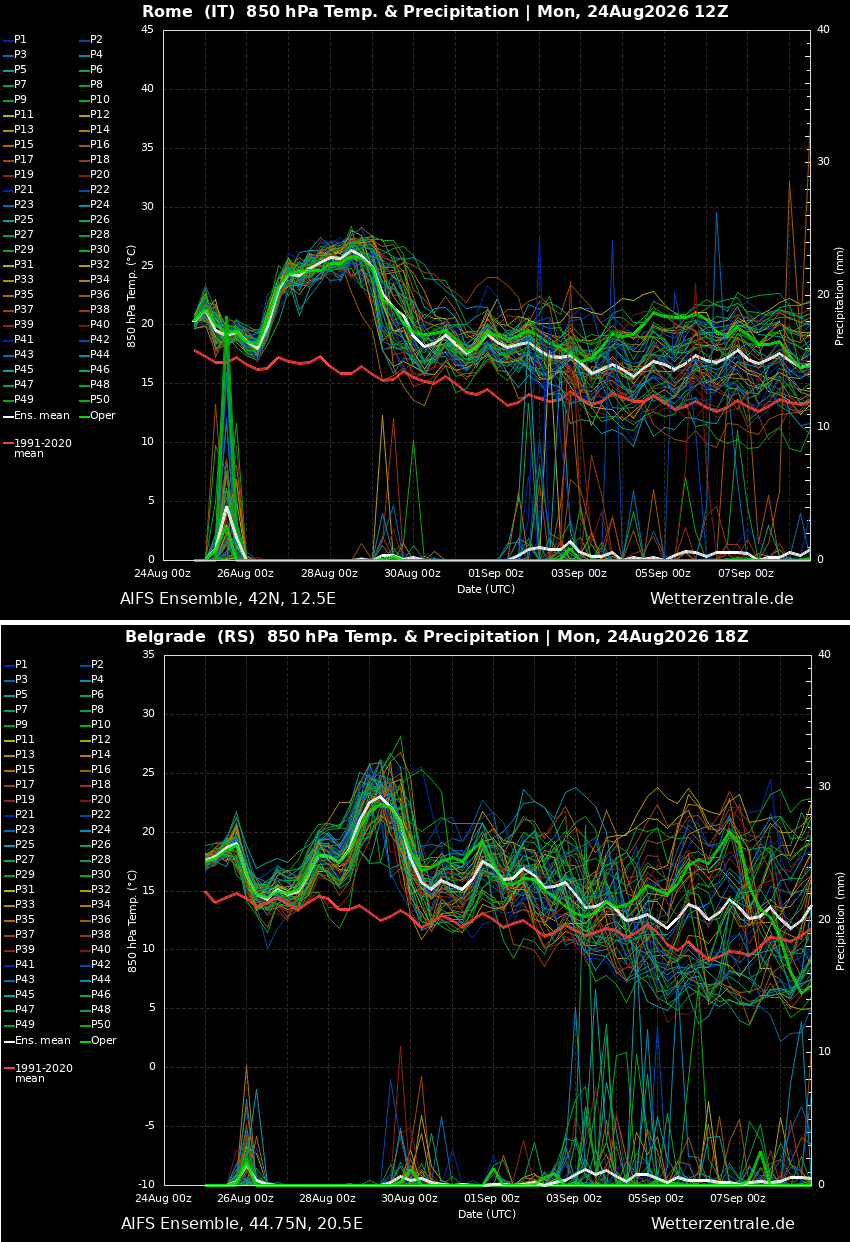
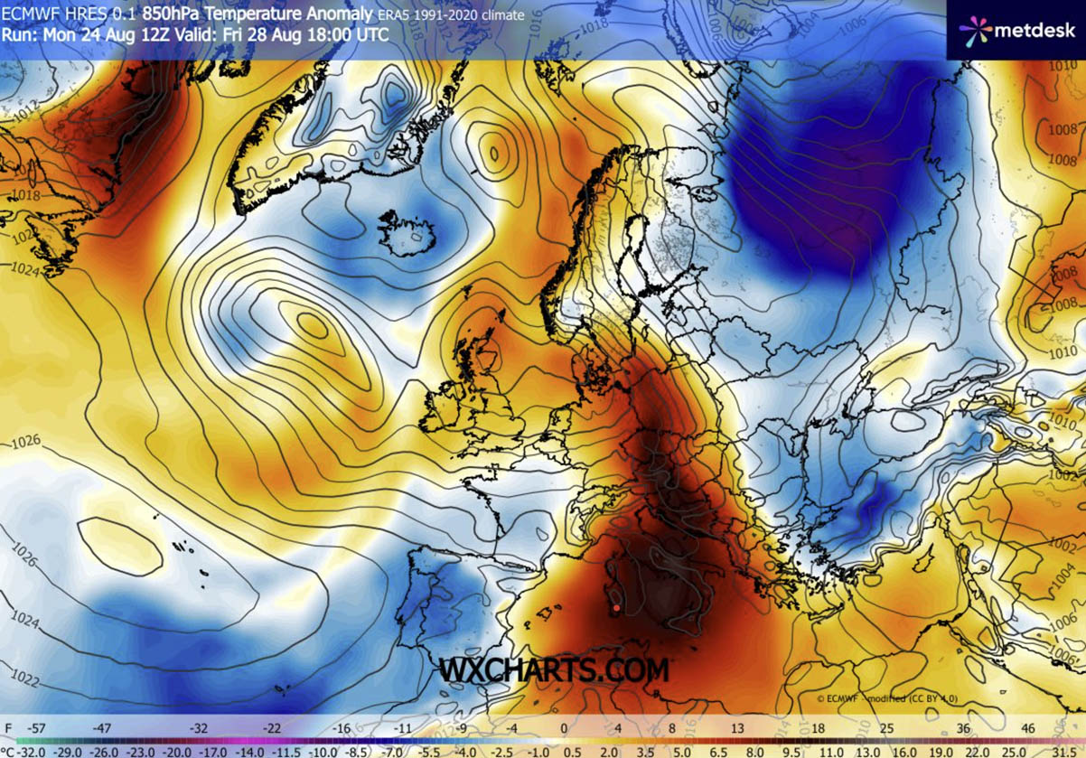
The core of the heat dome reaches its absolute peak between Thursday and Saturday. The most extreme temperature anomalies are concentrated over Italy, the Pannonian plains of Hungary, northern Serbia, eastern Croatia, and Bosnia and Herzegovina. During this 48-to-72-hour window, cities like Rome and Belgrade are enduring afternoon highs in the low 40s. Meanwhile, the intense thermal contrast along the western flank of the ridge is sparking explosive atmospheric instability over France.
Weekend Shift: Migration East and Atlantic Relief
Forecast models indicate that the heat dome will begin to elongate and shift eastward by the end of the weekend. While Western Europe—including Portugal, Spain, and parts of France—begins to experience refreshing maritime air masses sweeping in from the Atlantic, the oppressive heat will migrate toward the Balkans, Poland, and western Ukraine. The extreme anomalies are expected to gradually dissipate from west to east as the blocking pattern breaks down heading into early September.
Supporting Data and Meteorological Dynamics
To understand the severity of the current event, meteorologists look closely at the physical mechanics of the upper troposphere and surface anomalies.
How a Heat Dome Operates
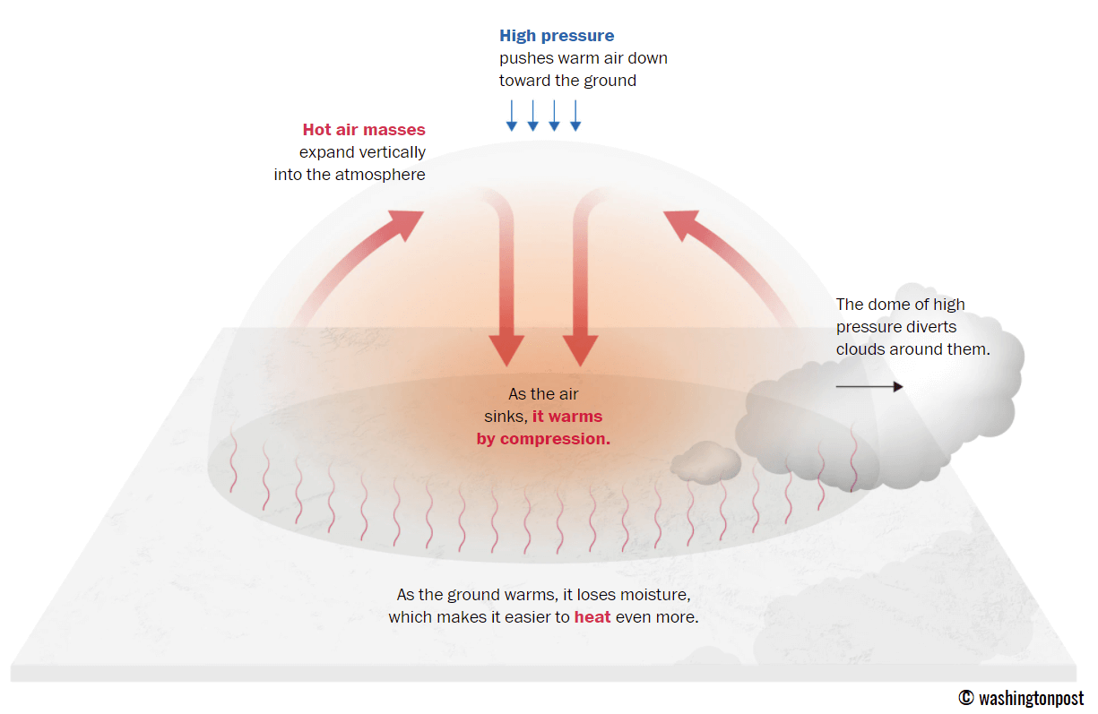
A heat dome forms when a broad, stagnant area of high pressure parks over a vast continental region for days or weeks. Acting much like a lid on a boiling pot, the upper-level ridge traps warm air beneath it. As air layers sink toward the ground, they undergo adiabatic compression—meaning the air is squeezed and heated under increasing pressure. This continuous downward motion clears skies, allowing maximum solar radiation to bake the surface while sealing the hot air mass in place.
      [ UPPER-LEVEL RIDGE / BLOCKING HIGH ]
              (Sinking, Compressing Air)
                          │
                          ▼
             ~~~~~~~~~~~~~~~~~~~~~~~~~  <-- "Atmospheric Lid"
              Trapped Heat & Moisture
             ~~~~~~~~~~~~~~~~~~~~~~~~~
                          │
                          ▼
            [ SURFACE HEAT DOME: 38°C - 43°C ]
    (Urban Corridors, Low River Basins, Pannonian Plains)
Temperature Anomalies and 850 hPa Levels
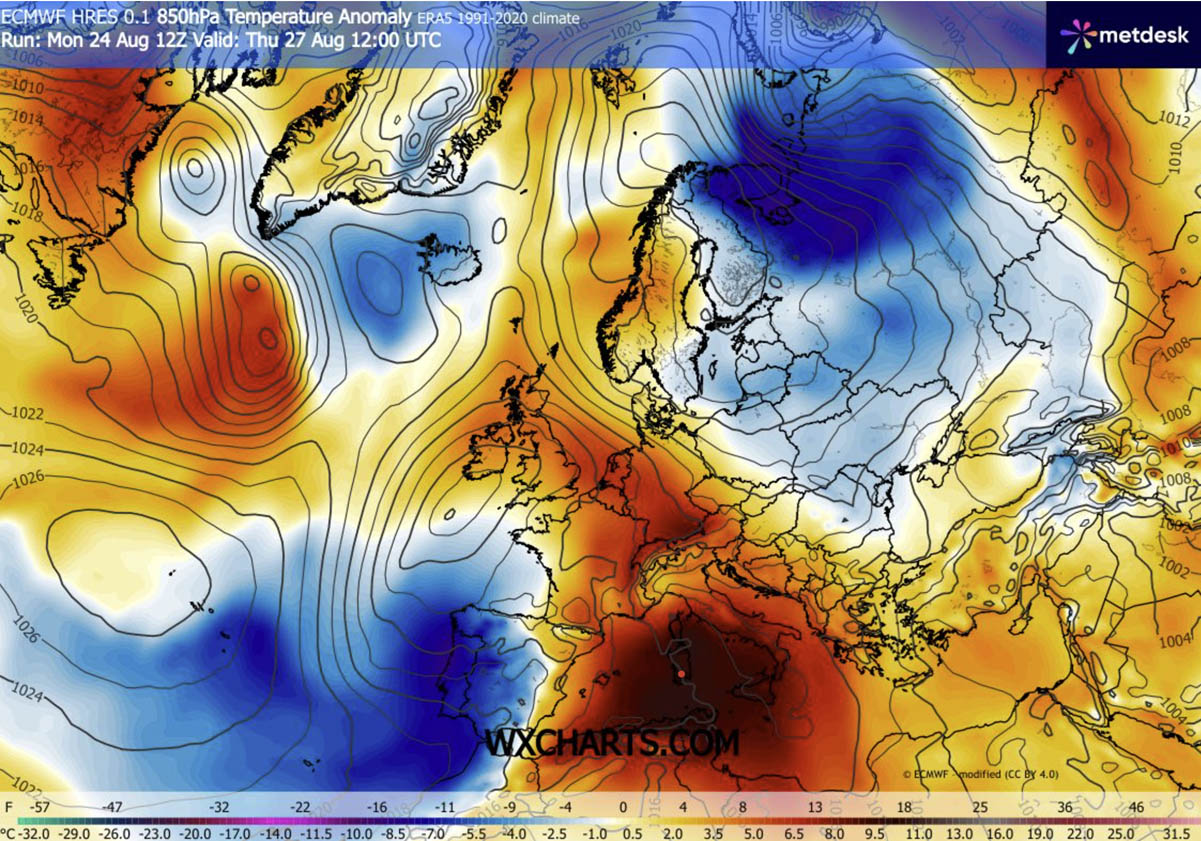
At the 850 hPa level (roughly 1,500 meters above sea level), thermal charts show core temperature anomalies surging significantly above normal across the Mediterranean and Central Europe. Surface models (2-meter temperature anomalies) verify that widespread regions are experiencing temperatures 12°C to 16°C higher than historical climate baselines for late August.
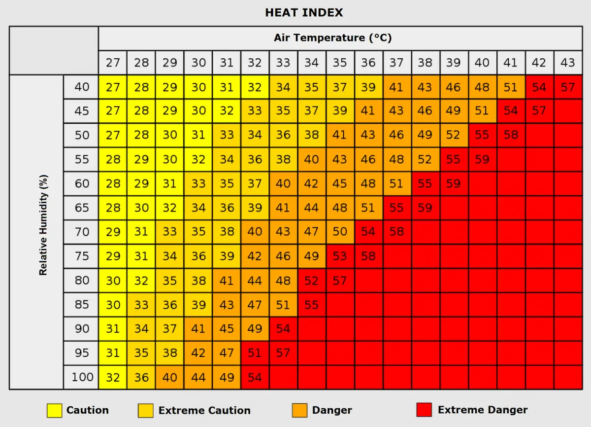
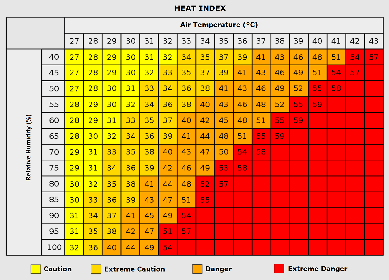
When combined with high relative humidity in certain microclimates, the Heat Index—which measures how hot it actually feels to the human body—soars. For instance, an air temperature of 35°C paired with humidity levels exceeding 80% can push apparent "feel-like" temperatures near 50°C (122°F), pushing human physiological thresholds to their absolute limits.
Human and Infrastructure Impacts
The cascading effects of a persistent heat dome extend far beyond uncomfortable weather; they pose profound public health and societal challenges.
Public Health and Nocturnal Heat Stress
Public health officials have issued urgent advisories, noting that the greatest danger of prolonged heat waves often lies in the lack of nighttime relief. When overnight temperatures refuse to drop below 24°C to 26°C, the human body cannot cool down or regulate core temperature effectively. This continuous physiological strain dramatically increases the incidence of heat exhaustion, heat stroke, acute cardiovascular events (such as heart attacks and strokes), and respiratory complications.
Vulnerable populations bear the brunt of these impacts. The elderly, young children, and individuals with pre-existing chronic conditions face heightened mortality risks. Furthermore, outdoor laborers—including agricultural workers, construction crews, and delivery personnel—are at extreme risk of occupational heat illness. Socioeconomic disparities also play a fatal role, as lower-income urban residents frequently live in dense concrete and asphalt environments that lack green spaces and trap heat long after sunset.
Energy Grids and Environmental Stresses
As millions of residents turn on air conditioning units to cope with the sweltering conditions, regional energy grids face unprecedented spikes in power demand. Power operators remain on high alert for localized brownouts and blackouts. Simultaneously, the combination of high temperatures and dry continental winds accelerates soil moisture loss, rapidly drying out vegetation and creating explosive wildfire conditions across southern and central European valleys.
Implications: A Dangerous Convergence of Extremes
While the southern and central portions of the continent bake under the heat dome, the dramatic boundary between this thermal monster and cooler Atlantic air is generating severe secondary threats.
On Thursday, the violent pressure and temperature gradient between the Mediterranean ridge and a deep Atlantic trough over western Iberia established robust southwesterly jet-stream winds across eastern Spain and into France. This dynamic is delivering intense vertical wind shear. Coupled with extreme convective available potential energy (CAPE) values ranging from 3,000 to nearly 5,000 J/kg—fueled by a historically warm Mediterranean Sea—the region faces a severe thunderstorm setup.
Meteorologists warn that these ingredients will produce explosive, highly organized supercell thunderstorms capable of dropping very large to giant hail, unleashing destructive straight-line winds, triggering torrential flash floods, and carrying a non-zero risk of tornadoes across parts of France and the western Alps.
As Europe navigates the closing weeks of meteorological summer 2026, the simultaneous onslaught of historic heat domes and volatile severe weather outbreaks underscores an increasingly dynamic and high-stakes atmospheric landscape. Forecasters emphasize that while relief is on the horizon for Western Europe, residents further east must remain vigilant as the heat anomaly shifts position heading into September.
