

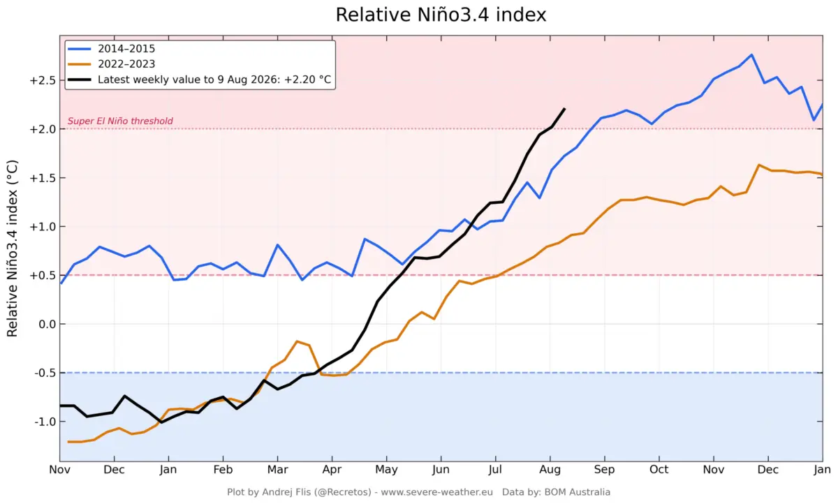
GLOBAL — Atmospheric scientists and climatologists are tracking the unprecedented acceleration of a Super El Niño across the tropical Pacific. New oceanographic and meteorological datasets indicate that the event is developing at a pace that eclipses historical benchmarks, surpassing even the rapid onset phases of the legendary 2015–2016 cycle.

Driven by an explosive combination of subsurface thermal energy and record-shattering low-level westerly wind bursts, long-range numerical models have continually upgraded their peak projections. The unfolding phenomenon is pushing deeper into historic territory, directly reshaping global atmospheric circulation and locking in high-impact seasonal forecasts for the United States, Canada, and Europe through the Fall of 2026 and Winter of 2026/2027.
Main Facts: The Anatomy of an Extreme ENSO Event
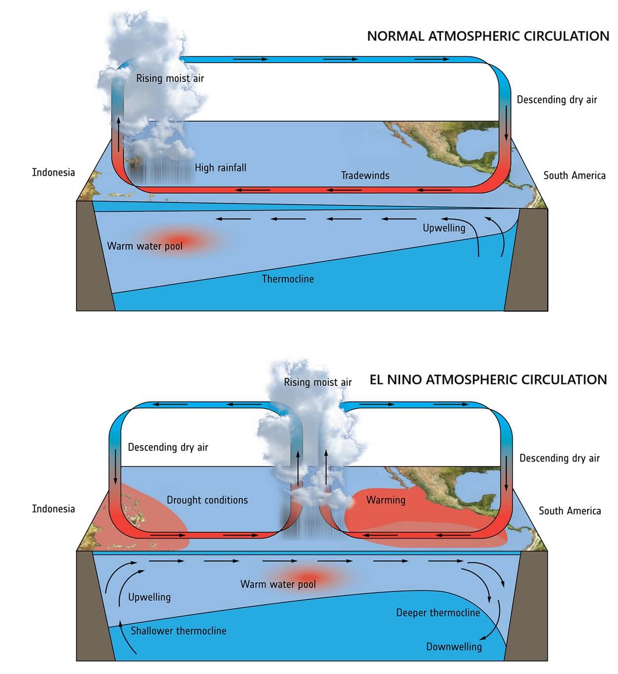
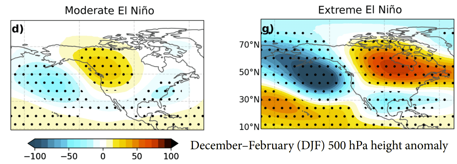
The El Niño-Southern Oscillation (ENSO) is currently transitioning aggressively into an extreme positive phase. While moderate El Niño episodes typically generate gentle, undulating wave patterns across the global jet stream, a "Super" event acts as a macroeconomic shock to the global climate system, forcing radical reorganizations of pressure fields and wind belts.
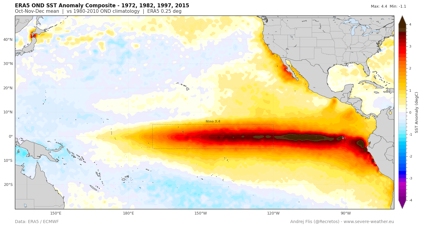
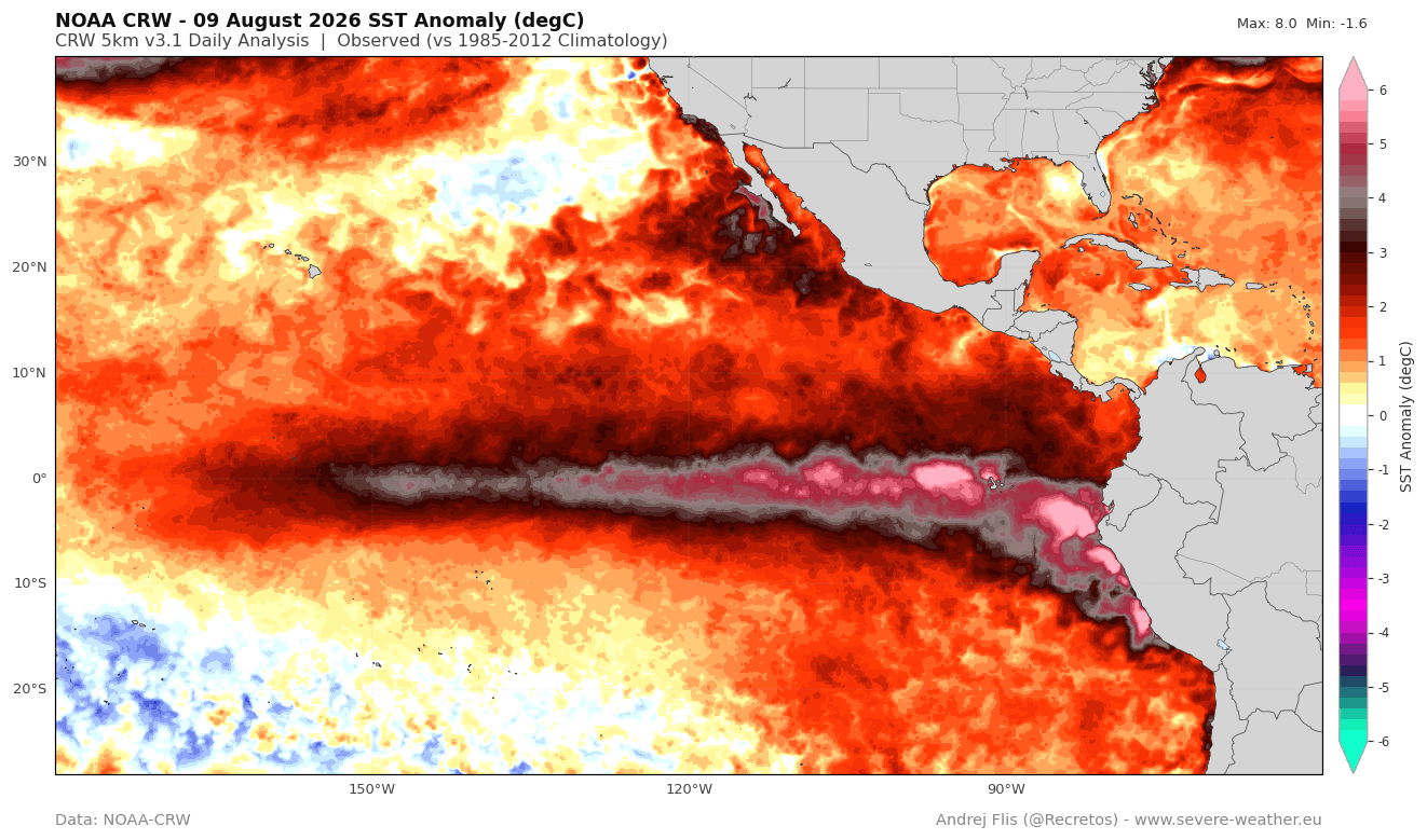
- Rapid Surface Warming: Sea surface temperature anomalies in the central and eastern tropical Pacific have surged dramatically, with localized peaks registering more than 5°C to 6°C above the long-term average.
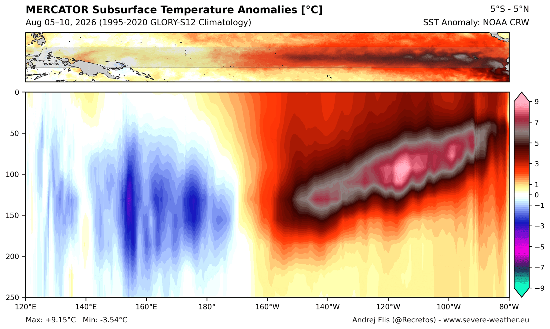
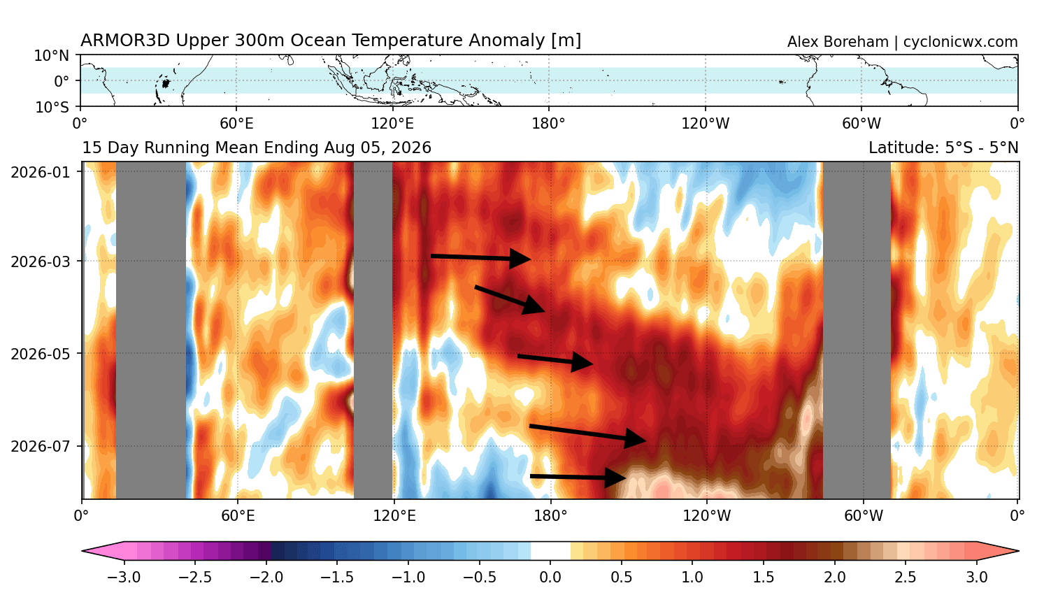
- Subsurface Engines (Kelvin Waves): Beneath the surface, a massive downwelling Kelvin Wave is propagating eastward, carrying thermal anomalies exceeding 9°C (16°F) within the top 250 meters of the ocean. This reservoir of heat guarantees a continuous, multi-month thermal supply well into the winter season.
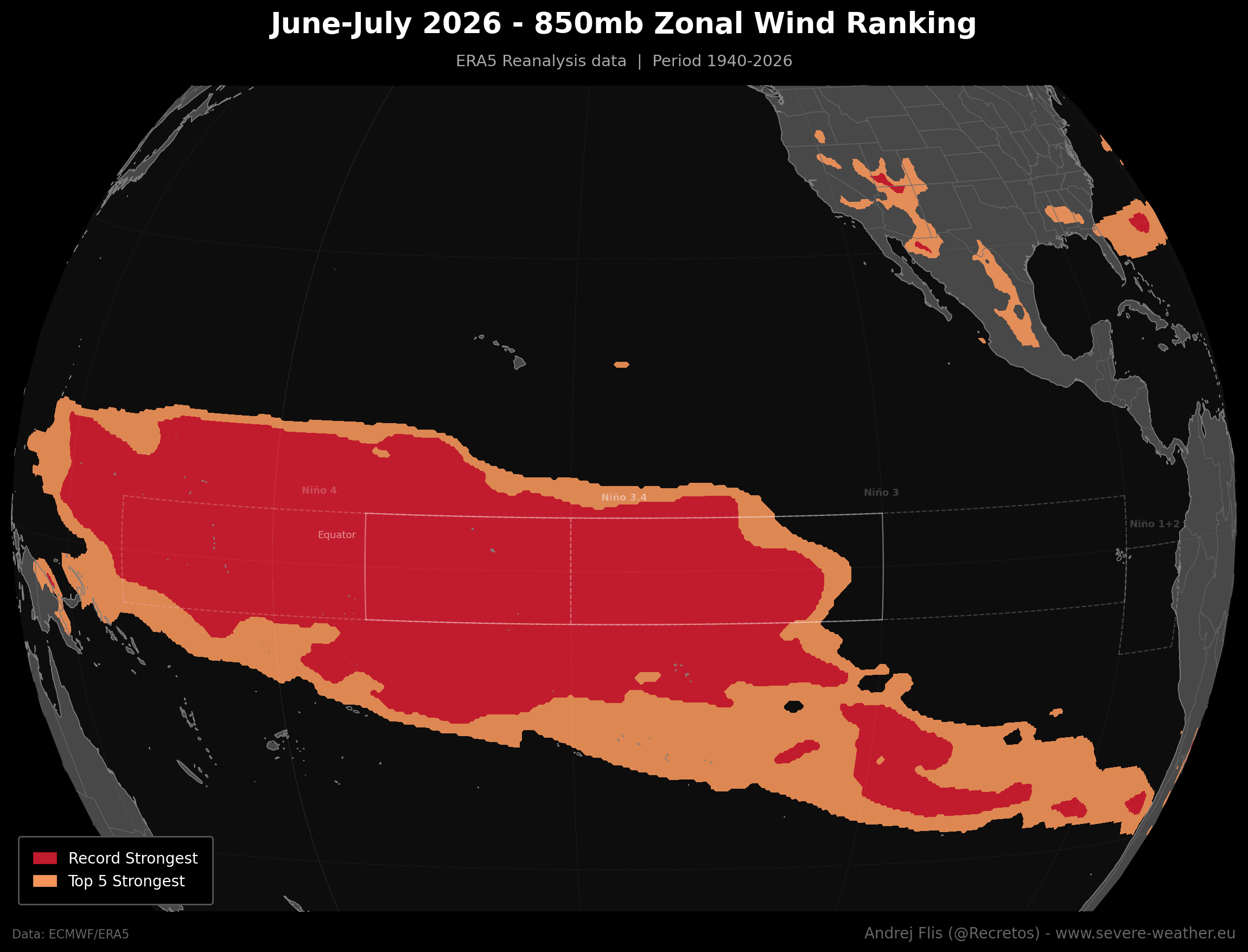
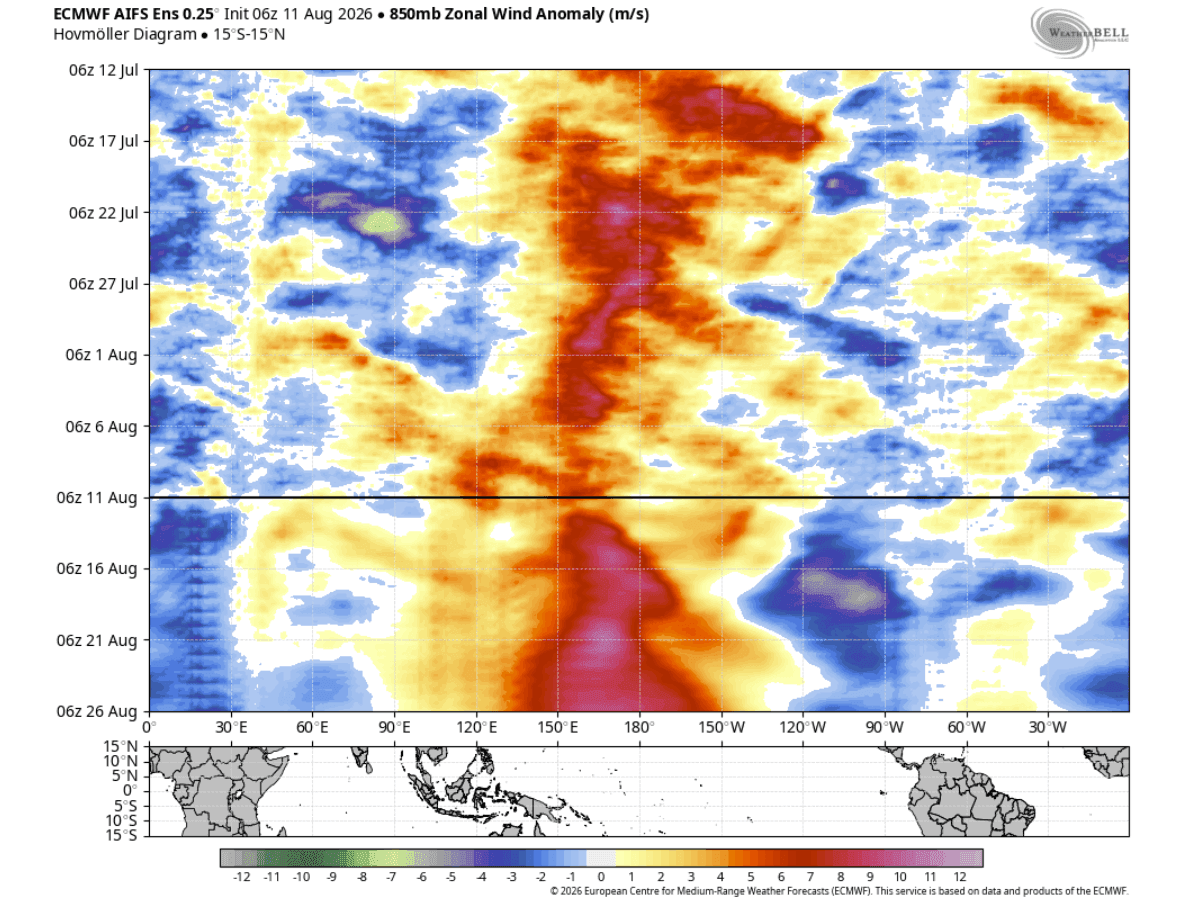
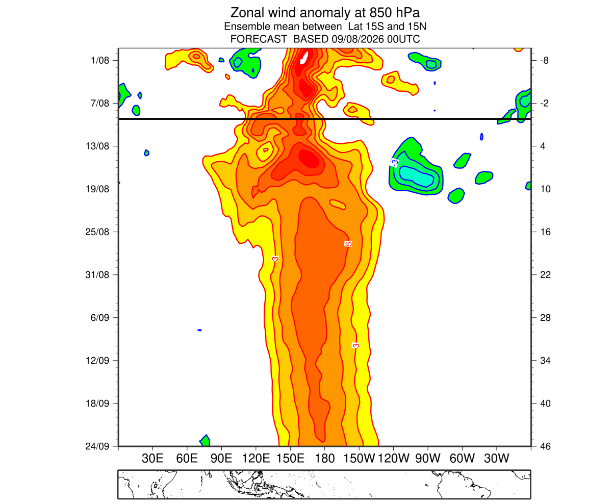
- Record Zonal Winds: ERA5 reanalysis data reveals that low-level westerly wind anomalies across the western and central equatorial Pacific reached unprecedented levels over a two-month average, setting an 86-year record for trade wind collapse during June and July.
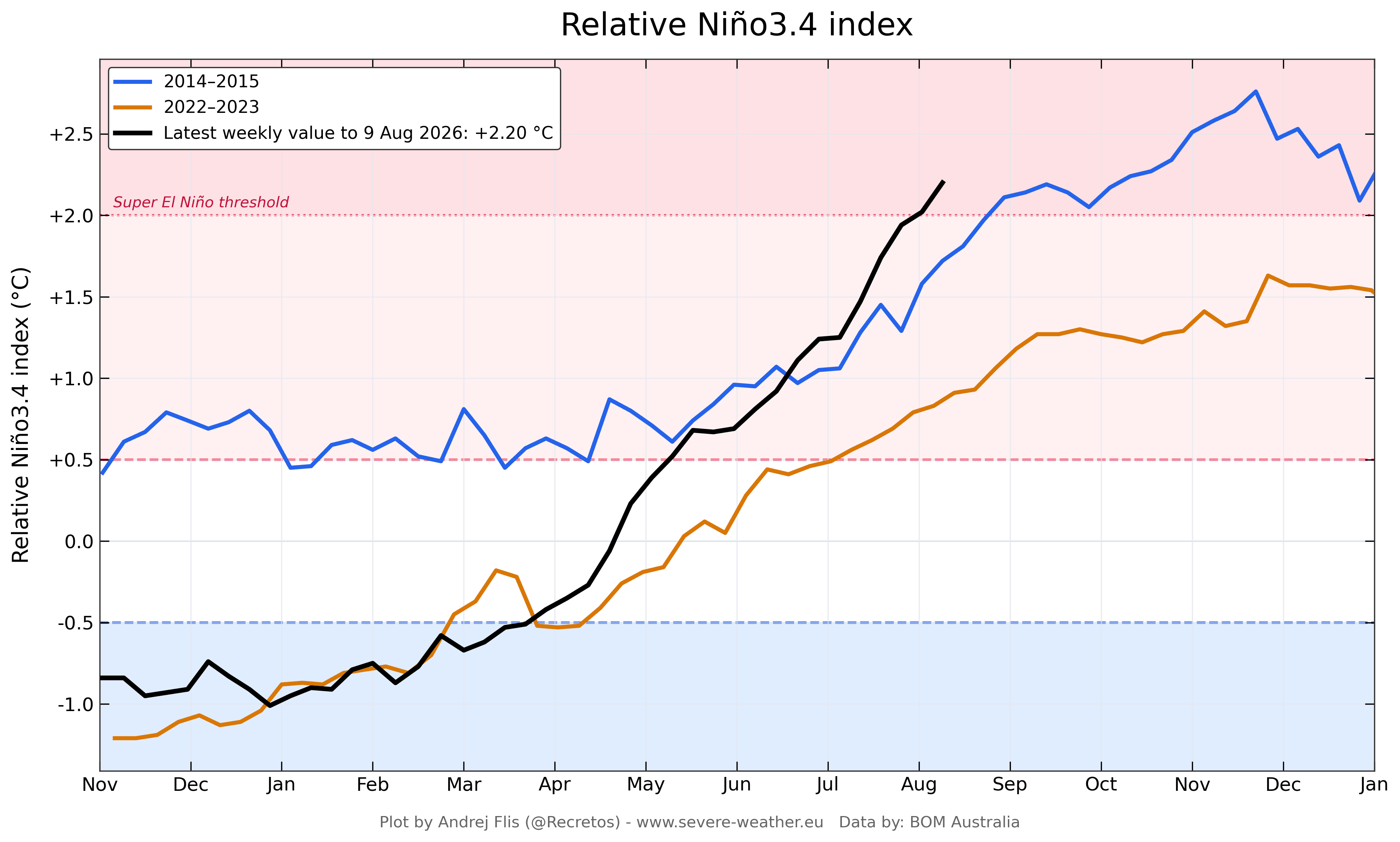
- Atmospheric Coupling: The Multivariate ENSO Index (MEI) recorded a historic bimonthly jump, climbing from a cool -1.0 in February–March to an extraordinary +2.4 in June–July—the highest reading for this period since NOAA’s observational records began in 1979.
Chronology of Development: From Spring Acceleration to Late-Summer Surge
The trajectory of the 2026/2027 Super El Niño has caught several seasonal forecasting systems off guard due to the chaotic, short-term nature of westerly wind bursts.
Spring 2026: The Initial Spark
As the Northern Hemisphere transitioned out of spring, subtle indicators of an emerging El Niño began to appear. However, standard computer models failed to capture the true magnitude of the event because they could not simulate the intense localized wind anomalies that were silently brewing in the western Pacific. These westerly wind bursts piled up vast quantities of warm surface water, initiating a deep oceanic memory that would soon manifest as a massive subsurface Kelvin Wave.
Early Summer 2026: Breaking Historical Thresholds
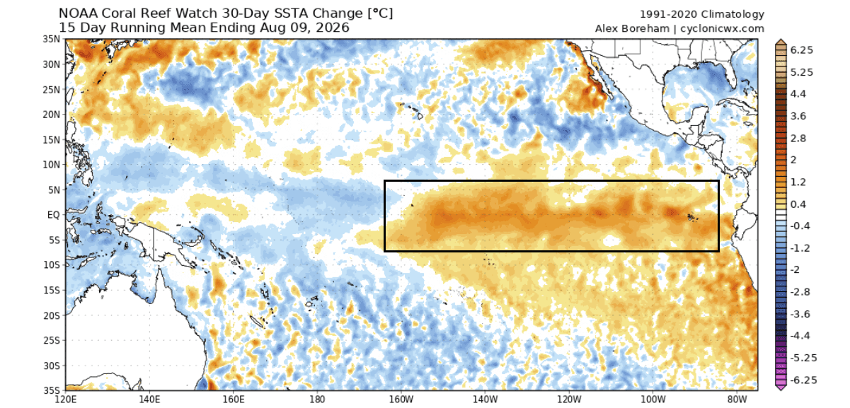
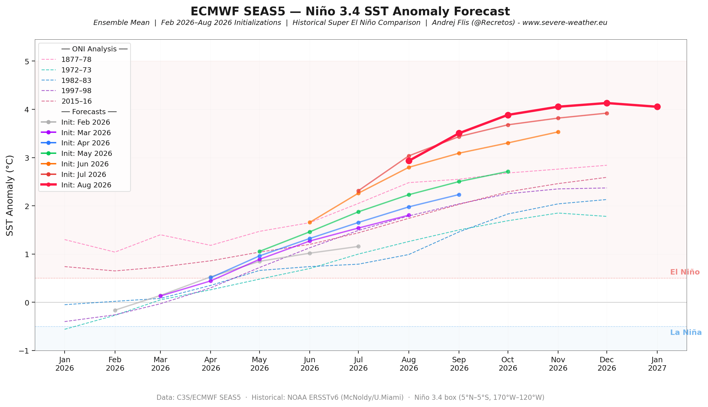
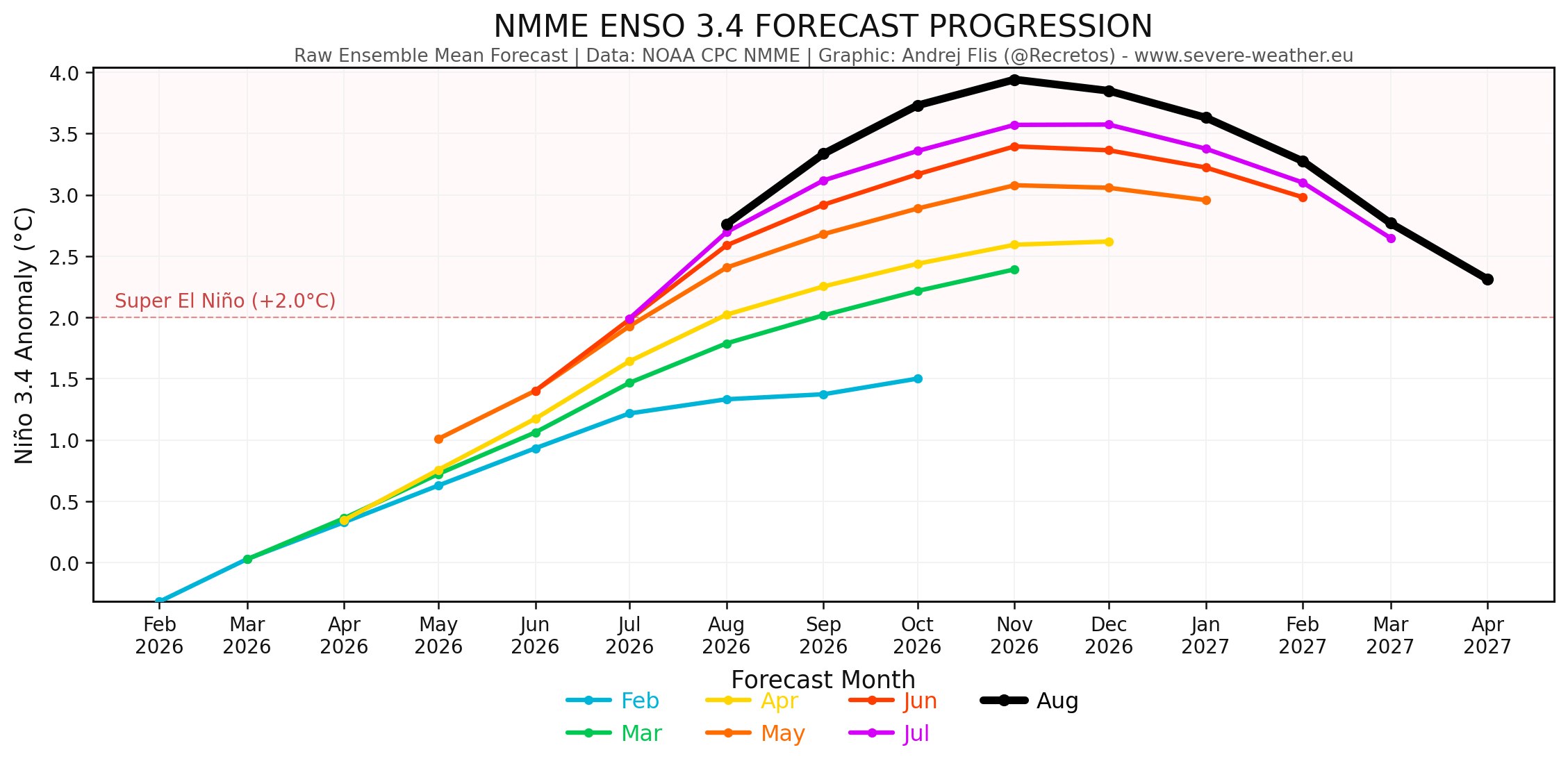
By June and July, the atmosphere and ocean entered a state of rapid coupling. The collapse of the equatorial trade winds allowed the subsurface thermal core to begin its eastward migration toward the South American coast. According to Bureau of Meteorology (BOM) weekly data, the relative ENSO index showed an acceleration that outpaced the 2015–2016 benchmark event. Consecutive runs of the ECMWF and NOAA NMME models began a stark upward revision trend, pushing projected peak anomalies firmly past the unofficial +3.0 threshold.
Late Summer 2026: Atmospheric Lockdown
By late August, the feedback loop between the ocean and atmosphere became self-sustaining. The continuous release of latent heat from the eastern Pacific forced the breakdown of transient weather disturbances, establishing a permanent, quasi-stationary "atmospheric standing wave." With the Walker Cell locked into place, the stage was set for early meteorological signals to bleed into the Northern Hemisphere’s autumn patterns.
Supporting Data: Oceanographic and Atmospheric Metrics
The scientific confidence behind the 2026/2027 Super El Niño forecast rests on a convergence of independent observational networks, reanalysis datasets, and ensemble modeling.
The Thermal Engine: Ocean Heat Content and Kelvin Waves
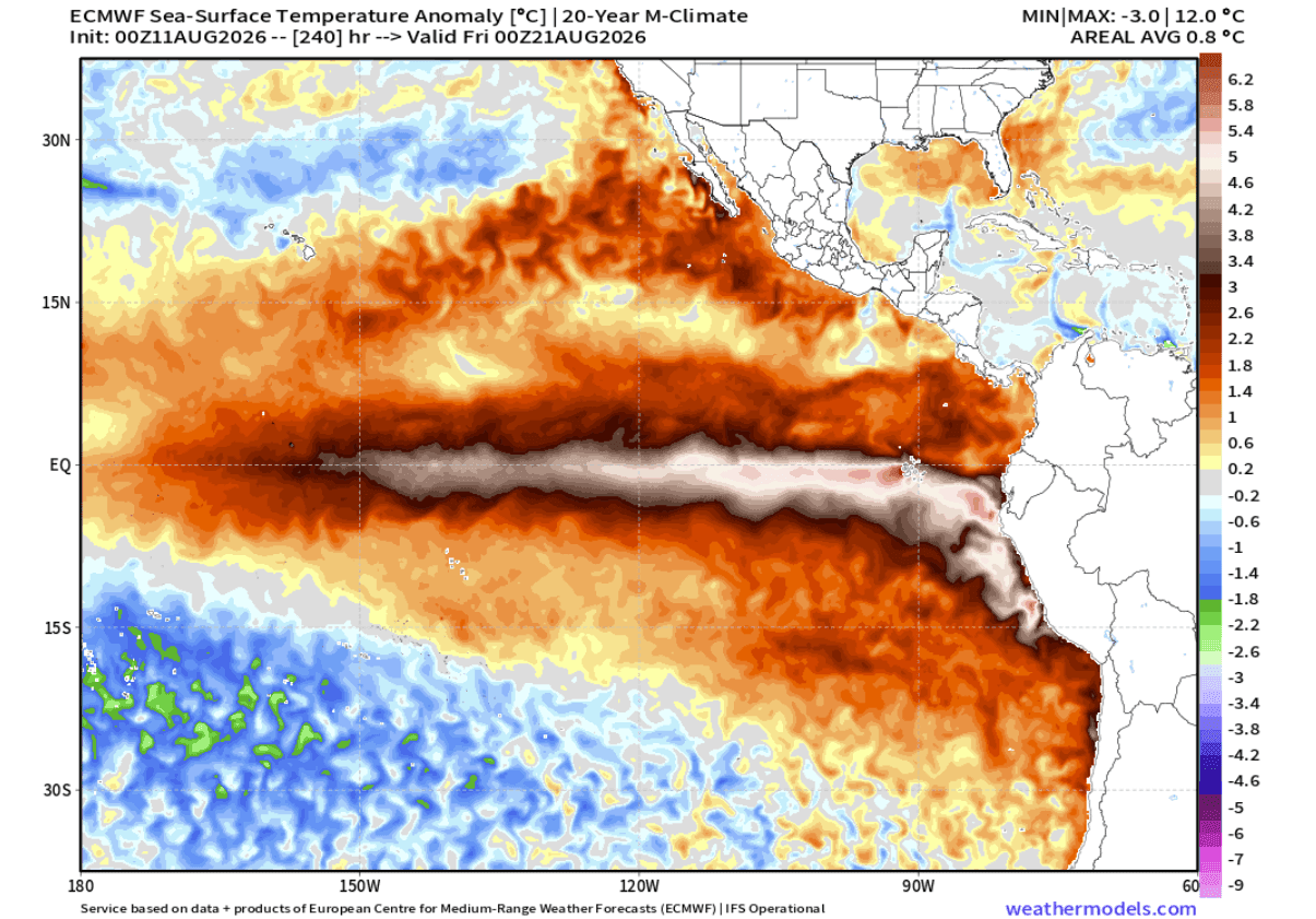
Ocean temperature anomaly charts provided by NOAA and the ECMWF highlight an expansive pool of anomalous warmth covering more than 10% of the global ocean surface. The vertical thermal profile of the tropical Pacific demonstrates why surface forecasts are continually revised upward: the subsurface warm core is not dissipating; rather, it is actively upwelling. As this deep thermal energy reaches the surface in the eastern Pacific, it ensures that the atmospheric forcing will remain robust throughout the peak of the winter season.
[Western Pacific]                              [Eastern Pacific / Americas]
   Warm Water Buildup  --->  Kelvin Wave (East)  --->  Surface Upwelling (+5°C to +6°C)
   (Westerly Wind Bursts)     (Subsurface 9°C+)          (Global Jet Stream Shift)
Atmospheric Response: The Velocity Potential Field
GDAS velocity potential data from July and August maps the clear division of the global Walker Cell. Broad regions of robust rising air anomalies (teal hues) are anchored directly over the central and eastern Pacific, driven by intense tropical convection and lower surface pressures. Conversely, powerful sinking motion dominates the Indian Ocean basin. This stationary configuration confirms that the Super El Niño is no longer a localized oceanic anomaly, but a master controller of global atmospheric momentum.
Official Responses and Meteorological Outlooks
Meteorological agencies worldwide, including the ECMWF, NOAA, and Copernicus, have issued synchronized outlooks emphasizing that this event deviates significantly from standard seasonal variability.
Forecasters note that while traditional El Niño indices classify anything above +2.0°C as a "Super" event, current model ensembles project anomalies reaching toward +4.0°C in core regions, with broader basin-wide extensions touching +7°C in the far eastern Pacific by November and December. This places the unfolding 2026/2027 event on par with, or exceeding, the most powerful climatic perturbations of the modern observational era.
Global Implications: Seasonal Weather Impacts for North America and Europe
The establishment of a high-amplitude global standing wave guarantees cascading impacts on regional weather patterns across the Northern Hemisphere.
United States and Canada: Fall Transitions and Winter Extremes
The atmospheric response is expressing itself unusually early. Typically, El Niño signatures remain muted during autumn, but the sheer strength of the 2026 event has forced an early winter-like pressure configuration for Fall 2026.
- Pressure Patterns: A prominent high-pressure blocking ridge is establishing itself over Canada, working in tandem with a deepened North Pacific low and an active southern jet stream.
- Precipitation and Temperatures: The southern United States is bracing for an active storm track, bringing increased rainfall and moisture from the Gulf Coast across to the Southeast. Meanwhile, the Pacific Northwest and southern Canada face drier-than-average conditions alongside above-normal temperatures under the Canadian ridge.
- Mid-to-Late Winter Snowfall Potential: Advanced CFSv2 and ECMWF projections for January and February 2027 suggest a potential eastward shift of the polar wave, raising the specter of significant cold air drops meeting the active southern moisture corridor. This configuration elevates the risk of major winter storms, ice events, and heavy snowfall anomalies across the Central Plains, Midwest, Mid-Atlantic, and the interior Northeast.
Europe: A Milder, Atlantic-Driven Westerly Regime
Downstream impacts across the Atlantic will also feel the influence of the North American teleconnection. The extension of low-pressure anomalies into the North and Northwest of Europe will maintain a robust westerly and southwesterly flow from the Atlantic basin.
- Temperatures: Most of continental Europe—particularly central, western, and southeastern regions—is favored to experience warmer-than-normal surface temperatures during the December–February window.
- Precipitation and Snow: The active westerly flow will inject abundant moisture into the continent, leading to above-normal precipitation totals across wide areas. However, persistent mild air masses will limit lowland snowfall, restricting significant snow accumulations primarily to northern Europe, northeastern sectors, and higher mountain elevations.
As the 2026/2027 Super El Niño continues its rapid ascent toward its late-autumn and early-winter peak, meteorological agencies will maintain round-the-clock surveillance. The coming months will test infrastructure, agricultural planning, and emergency preparedness as the planet adjusts to one of the most powerful climatic events in recorded history.
