

EUROPE — Meteorological authorities and severe weather forecasters have issued urgent warnings for a significant, multi-day severe weather outbreak poised to sweep across large portions of Western and Central Europe.
The severe weather setup, valid from 06:00 UTC on Thursday, August 27, through 06:00 UTC on Saturday, August 29, 2026, is expected to bring a volatile mix of atmospheric hazards. Forecaster Marko Korošec of Severe Weather Europe has highlighted the potential for an explosive convective event driven by extreme instability, high moisture levels, and intense wind shear.
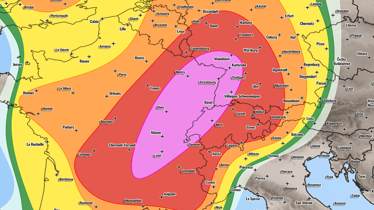
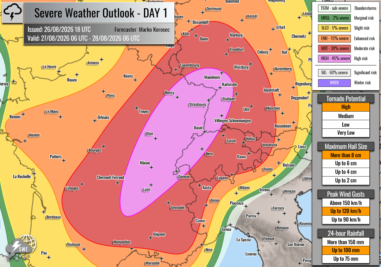
The unfolding weather scenario threatens densely populated regions from eastern France and western Switzerland into southwestern Germany on Thursday, before shifting eastward toward the Alpine region, the Czech Republic, and southwestern Poland on Friday. Authorities have placed large swathes of the continent under HIGH and Moderate (MDT) risk levels, signaling the potential for widespread property damage, life-threatening flash floods, destructive straight-line winds, tornadoes, and very large to giant hail measuring 6 to 10 centimeters (or even larger) in diameter.
Main Facts: The Anatomy of a Continental Severe Weather Threat
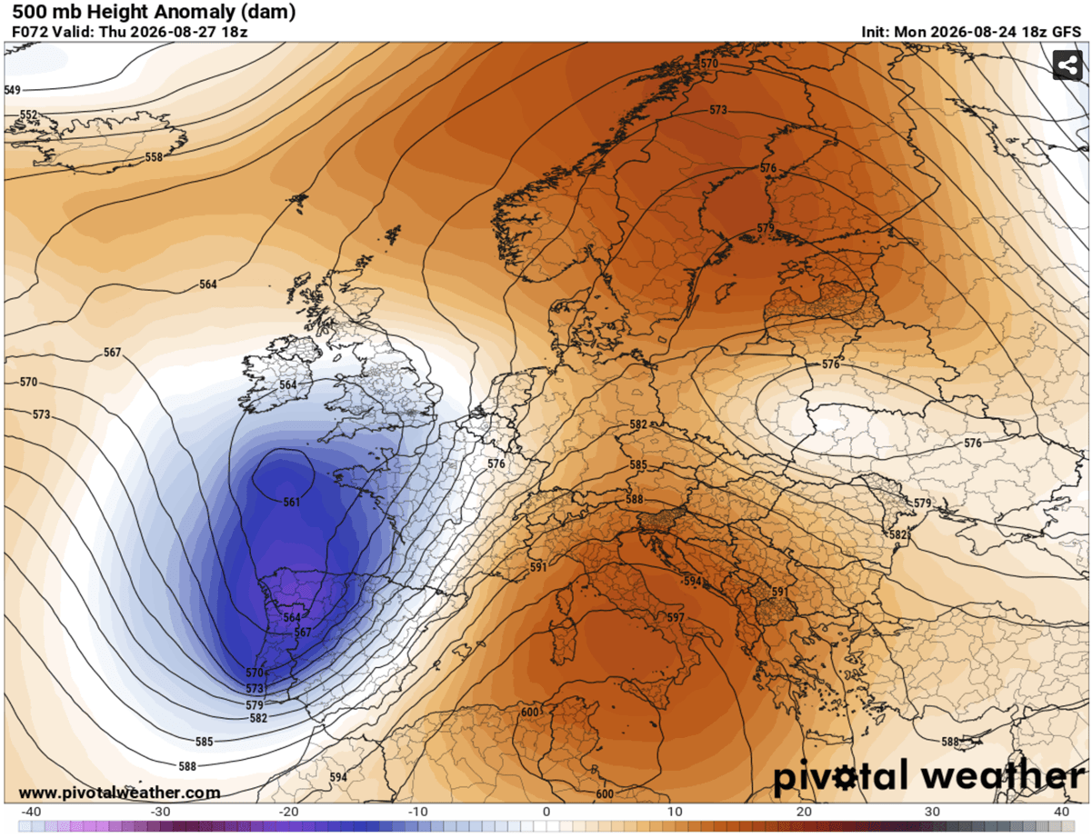
At the heart of this severe weather outbreak is a classic, highly volatile synoptic setup. A large and deep upper-level trough is currently emerging into Western Europe, blocked by a robust and stubborn high-pressure ridge parked over the Mediterranean region and the Balkans.
Sandwiched between these two massive atmospheric features is a powerful southwesterly jet stream. This jet is funneling copious amounts of exceptionally warm, moisture-laden air northward from the western Mediterranean—a region currently enduring an intense summer heatwave—right into the heart of France and Central Europe.
The contrast between the cool, dynamic upper-level air associated with the advancing trough and the hyper-humid, unstable airmass near the surface is creating a steep temperature and pressure gradient. This environment provides the two critical ingredients for severe weather on a grand scale:
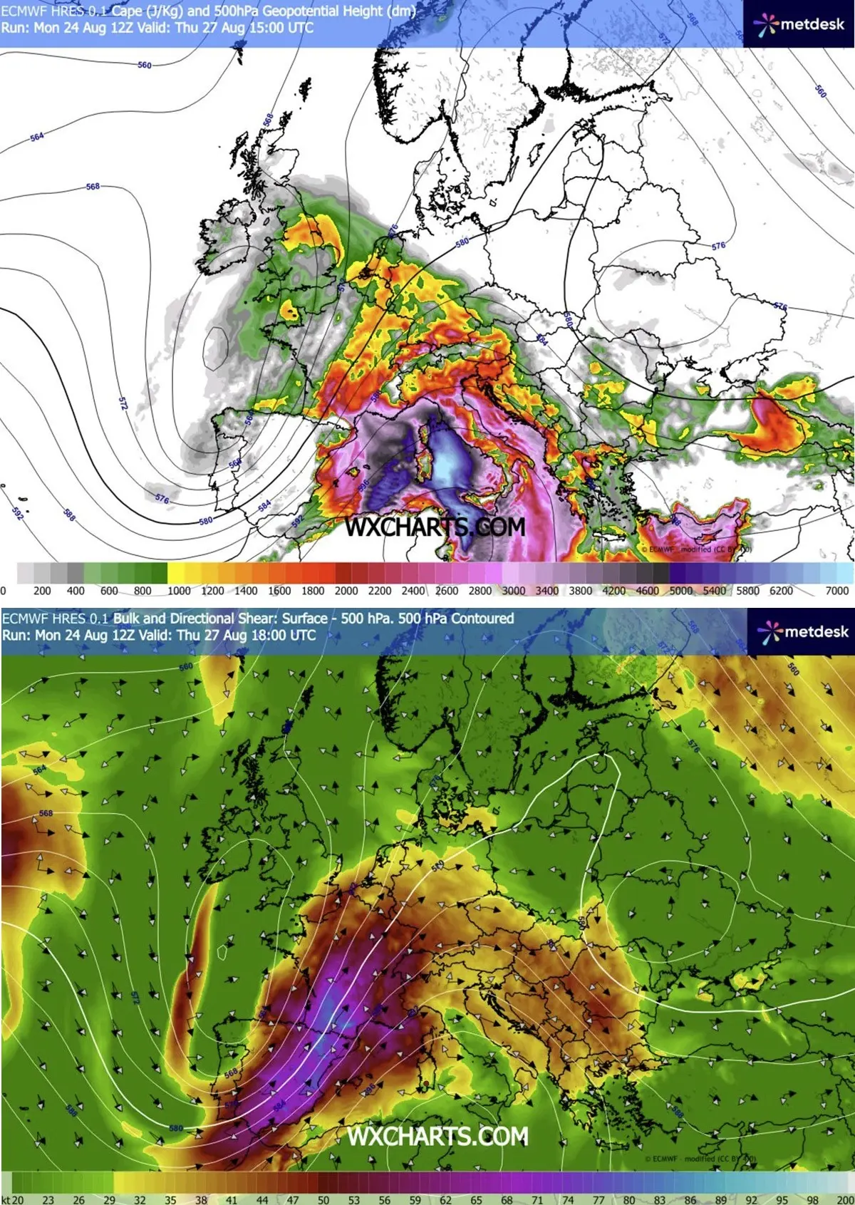
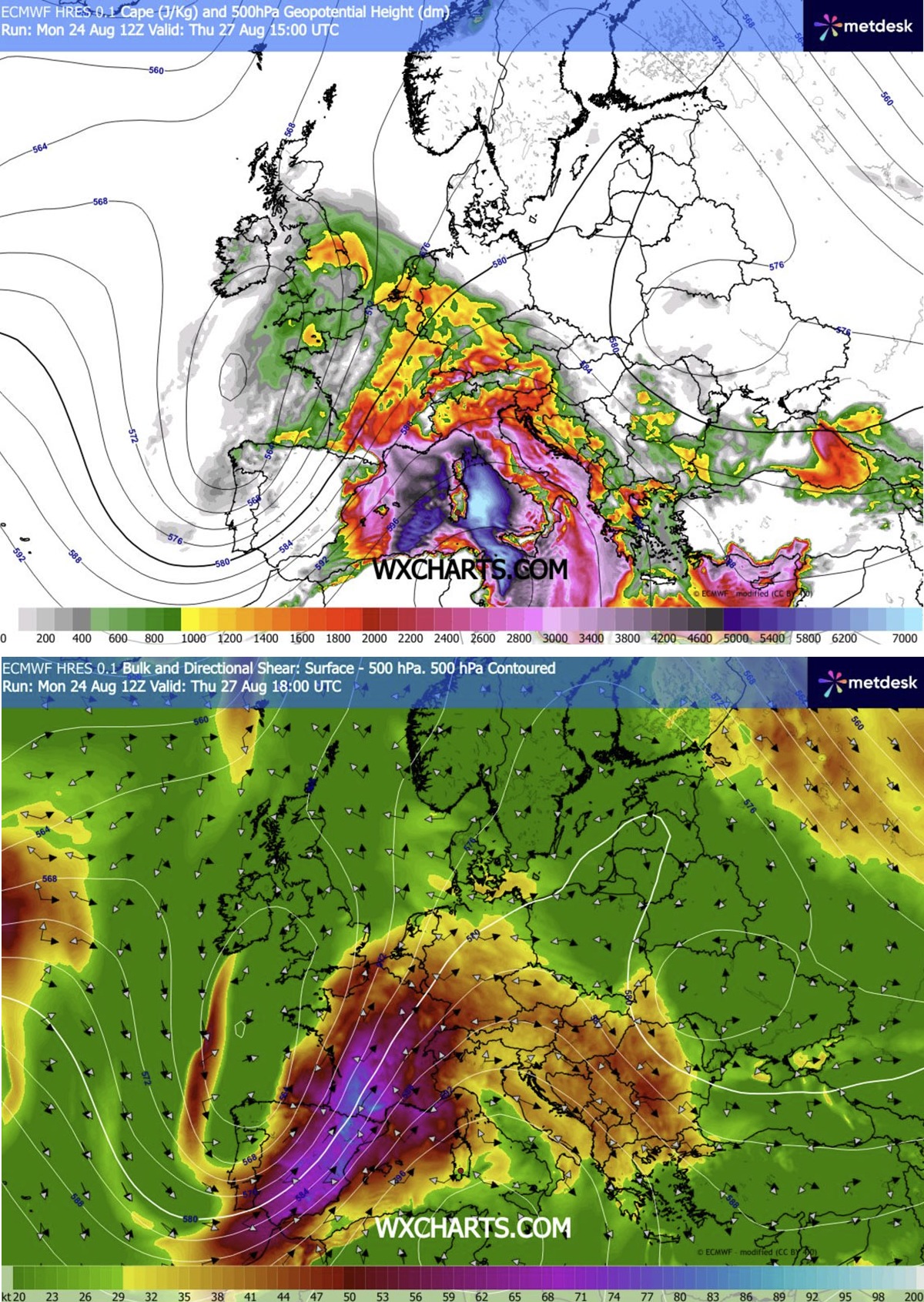
- Extreme Instability: Mixed-Layer CAPE (Convective Available Potential Energy) values are forecast to surge between 2,000 and 4,000+ J/kg across southeastern France.
- Violent Wind Shear: Intense mid-level jet dynamics are overspreading the region, providing robust directional and speed shear capable of sustaining rotating updrafts and long-lived supercell thunderstorms.
Because of these compounding factors, forecasters have escalated threat levels. Rare HIGH risks have been declared for portions of east-central France, western Switzerland, and southwestern Germany on Thursday, followed by expansive MDT risks covering eastern Switzerland, Austria, the Alpine corridor, the Czech Republic, and southwestern Poland on Friday.
Chronology of the Outbreak: Day-by-Day Progression
Thursday, August 27: France, Switzerland, and Germany
The first phase of the outbreak begins in earnest around midday Thursday. As daytime heating maximizes, convective temperatures will be breached, leading to the explosive development of discrete storms over the Massif Central in France.
- Afternoon: Storms will rapidly propagate into the Rhône Valley, fueled by strong, moist southerly low-level winds. This environment is highly supportive of isolated, intense supercells capable of dropping giant hail, unleashing torrential downpours, and producing tornadoes—particularly in the Rhône Valley where low-level shear and storm-relative helicity will peak.
- Late Afternoon & Evening: The activity will march rapidly east-northeastward on the back of strong upper-level winds, crossing into western Switzerland and southwestern Germany. As night falls, individual supercells are expected to cluster into larger convective systems. These clusters will pose a formidable threat of damaging, straight-line winds, wind-driven large hail, and localized flash flooding.
- Northern Extensions: Simultaneously, a secondary zone of enhanced storm activity is expected to develop further north toward the Benelux union and western Germany as the main wave axis shifts. Southern England may also experience isolated severe storms during peak heating hours.
Friday, August 28 into Saturday, August 29: The Alps, Czech Republic, and Poland
The focal point of the severe weather shifts eastward on Friday, targeting the Alpine regions and Central Europe.
- Early Afternoon: Isolated thunderstorms will initiate over the complex terrain of the Alps, aided by moderately strong instability and lingering wind shear. Initial storm modes will favor severe multi-cells and supercells.
- Late Afternoon & Evening: High-resolution meteorological models indicate a growing risk that these storms will rapidly coalesce into one or more large Mesoscale Convective Systems (MCSs) or bow echoes. These organized systems will sweep across southeastern Germany, northeastern Austria, and into the southwestern Czech Republic.
- Overnight: Forecasters warn that if bowing segments within the MCS materialize, destructive straight-line wind gusts exceeding 120 km/h could develop. This catastrophic wind threat is projected to spread northeastward into southwestern Poland through the overnight hours before finally weakening toward early Saturday morning.
Supporting Data and Meteorological Modeling
The severity of the upcoming event is cross-verified by several leading meteorological models, including high-resolution WRF runs, as well as data visualizations provided by Meteoadriatic, Wxcharts, and PivotalWeather.
Key data points driving the high-risk categorization include:
- Dewpoint Anomalies: Unprecedented moisture pooling ahead of the incoming cold front, drawing directly from the super-heated Mediterranean Sea.
- CAPEKinematics: The coexistence of 4,000 J/kg of CAPE with deep-layer shear exceeding 25–30 meters per second (55–65 knots), an overlapping profile typically associated with significant tornado outbreaks in North America, increasingly observed during extreme European heatwaves.
- Hail Accumulation Metrics: Sig-Tor (Significant Tornado) and Sig-Hail parameters indicating a multi-hazard threat where individual storms could produce hailstones ranging from 6 cm to upwards of 10 cm in diameter, posing severe hazards to vehicles, infrastructure, and agriculture.
Official Responses and Civil Preparedness
In light of the impending severe weather, civil protection agencies, municipal governments, and meteorological offices across France, Switzerland, Germany, Austria, the Czech Republic, and Poland have gone on high alert.
- France: Météo-France has ramped up warnings, advising citizens in the east-central departments to secure outdoor property, avoid unnecessary travel during peak storm hours, and stay clear of forested areas prone to falling branches or sudden flash floods.
- Germany: The Deutscher Wetterdienst (DWD) has issued advanced advisories warning of structural damage, fallen power lines, and dangerous driving conditions due to hydroplaning and localized flash floods, particularly along transit corridors in southwestern and central Germany.
- Switzerland & Austria: Alpine rescue teams and local authorities are bracing for potential flash flooding in narrow mountain valleys and mudslides triggered by excessive rainfall rates in short durations. Hikers and campers in high-altitude areas have been strongly urged to descend ahead of Thursday afternoon.
- Czech Republic and Poland: Emergency management agencies have placed local fire brigades and medical services on standby for overnight deployments on Friday, preparing for potential power outages and structural repairs stemming from destructive straight-line winds.
Implications for Infrastructure, Agriculture, and Economy
A severe weather outbreak of this magnitude carries profound socio-economic implications for the affected European corridors:
- Agricultural Devastation: With giant hail (up to 10 cm) explicitly forecast, vineyards across France, Germany, and parts of Central Europe face catastrophic risks. Fruit orchards, grain crops, and greenhouses sit squarely in the path of the highest risk zones, potentially wiping out late-summer harvests in a matter of minutes.
- Transportation Disruption: Major European transit arteries—including vital autobahns in Germany, high-speed rail networks (TGV and ICE), and key air hubs—face severe delays and cancellations. Intense rainfall and wind shear present distinct hazards to aviation during takeoff and landing phases.
- Power Grid Vulnerability: Straight-line winds gusting up to or exceeding 120 km/h will test the resilience of regional electrical grids. Widespread tree damage interacting with overhead lines is expected to cause localized power outages lasting anywhere from several hours to days in hard-hit rural areas.
- Urban Flash Flooding: In densely built-up urban centers where impermeable surfaces prevent rapid infiltration, intense downpours falling at rates exceeding 50 mm per hour will overwhelm storm drainage systems, leading to rapid street flooding and subterranean water intrusion.
Residents and visitors across the highlighted risk zones are strongly advised to monitor real-time weather radar, heed local emergency directives, and ensure safety measures are completed before the storms arrive.
