

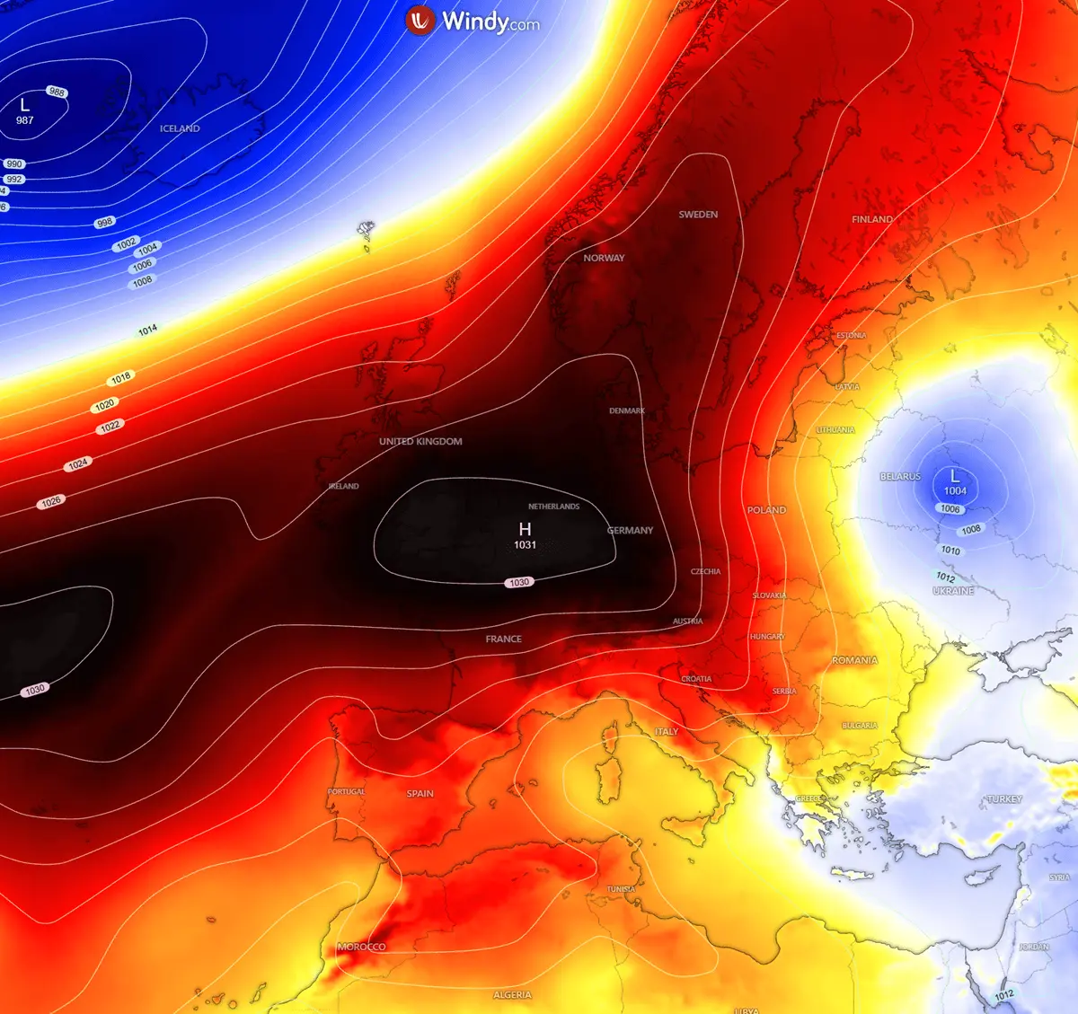
BERLIN/BELGRADE — A dramatic and unseasonal shift in Europe’s weather pattern is underway, bringing an abrupt end to late-summer warmth across the eastern half of the continent. Driven by a powerful high-pressure blocking system over the North Atlantic and Scandinavia, a massive surge of dense, polar-origin air has begun spilling deep into Eastern Europe and the Balkan Peninsula.
Meteorologists note that daytime high temperatures across the impacted regions are plunging by 10°C to 15°C below recent seasonal averages. While the cold intrusion is expected to be relatively short-lived—receding by the weekend—its intensity is catching many communities off guard, threatening early-season agricultural damage, dusting regional mountain peaks with autumn’s first snow, and signaling a sharp transition into the colder months of late 2026.

1. Main Facts: The Anatomy of a September Arctic Plunge
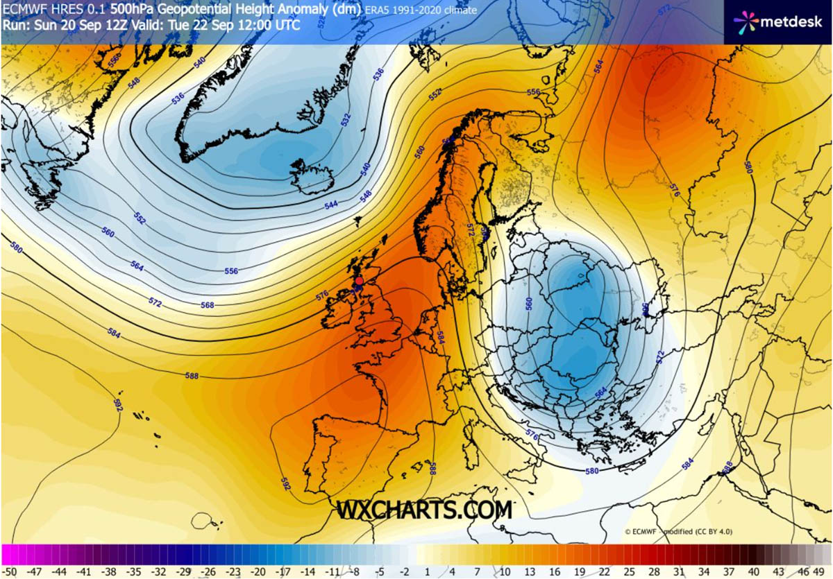
The core driver of this rapid thermal drop is a textbook meteorological setup: a sprawling upper-level blocking ridge anchored over Western and Northern Europe, juxtaposed with a deep trough sliding into Eastern Europe.
- The Mechanism: The high-pressure ridge over Scandinavia and the North Atlantic is establishing a direct atmospheric corridor for a meridional flow—a north-to-south air stream. This pathway allows unadulterated Arctic air to drain straight from the polar regions down across Eastern Europe, the Balkans, and eventually into Greece and western Turkey.
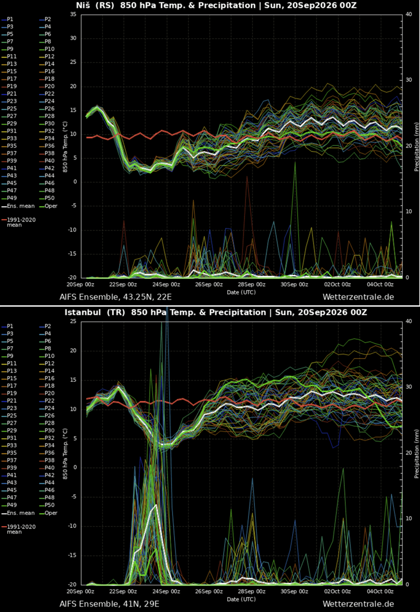
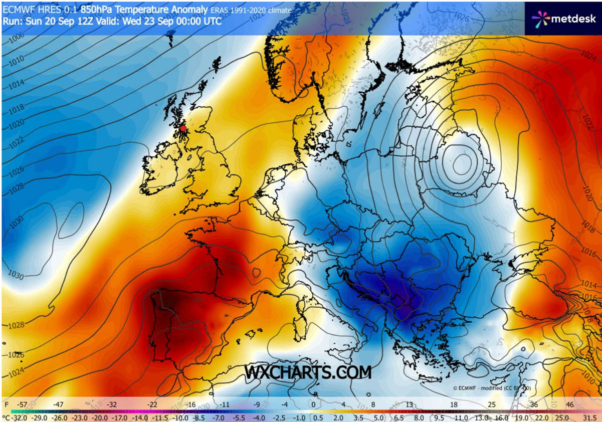
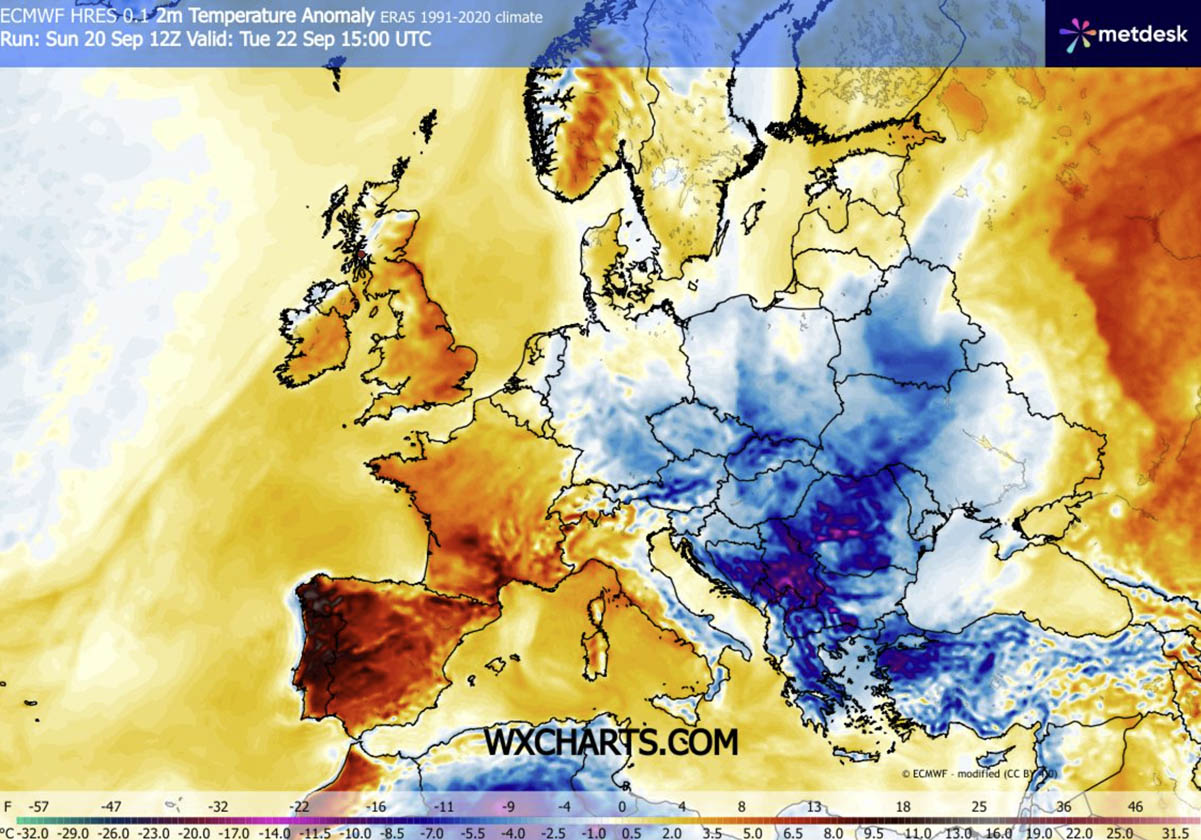
- Temperature Anomalies: At the 850 hPa level (roughly 1,500 meters altitude), temperatures are registering 6°C to 10°C below normal. At the surface, the thermal anomaly is even more striking. Countries like Serbia, Bosnia and Herzegovina, Romania, and Bulgaria are experiencing daytime highs 10°C to 15°C below long-term averages.
- A Divided Continent: Europe is effectively split in half. While Eastern and Southeastern Europe shiver under an Arctic blanket, Western Europe continues to bask in above-average warmth trapped beneath the persistent blocking ridge.
- Immediate Impacts: The system is triggering the first widespread nocturnal frosts in low-lying valleys and agricultural basins, while high-altitude regions—most notably the Carpathian Mountains and the Northern Balkans—are seeing their first notable high-altitude snowfalls of the autumn season.
2. Chronology: How the Polar Blast Unfolds Day by Day
The progression of the cold air mass is swift, cutting a southward swath across the continent over a 72-hour window.
Monday: The Gateway Opens
The synoptic pattern solidifies as the Scandinavian High strengthens and links with surface high-pressure systems moving into Central Europe. The pressure gradient tightens between the western ridge and the emerging eastern trough, opening the atmospheric floodgates for north-to-south winds. Cloud cover clears behind the advancing polar front, setting the stage for a rapid drop in overnight temperatures.
Tuesday: The Balkans and Central Europe Freeze
The Arctic air mass arrives in force across the Balkan Peninsula. Daytime temperatures in countries like Serbia, Bosnia, Romania, and Bulgaria plummet dramatically. Meteogram data for cities like Niš, Serbia, illustrate a vertical drop in the thermometer. Overnight, clear skies and diminishing winds allow radiational cooling to take hold, driving temperatures down into the low single digits and producing the first frost advisories for agricultural plains and valleys.
Wednesday: Reaching the Aegean and Western Turkey
The core of the upper-level cold wave shifts southward into the south-central Balkans, pushing the polar front toward Greece, the Aegean Sea, and the Black Sea region. Northwestern and western Turkey bear the brunt of the anomaly on Wednesday, with surface temperatures plunging 12°C to 16°C below normal. Tourists and locals alike in historically warm Mediterranean and Aegean destinations find themselves reaching for heavy jackets as daytime highs struggle to climb out of the upper teens and low twenties.
Thursday and Beyond: Gradual Recovery
By late Thursday and into the weekend, the dynamic core of the cold wave weakens as it moves further east into Asia Minor. Simultaneously, the western blocking ridge begins to nudge eastward, slowly re-establishing milder continental air over Central and Eastern Europe and bringing an end to the mid-week deep freeze.
3. Supporting Data and Meteorological Analysis
Advanced weather modeling—provided by institutions such as WetterZentrale and WXcharts—illustrates the severity of this September weather event.
- 850 hPa Anomalies: Mid-troposphere temperature anomaly maps highlight a sharp tongue of cold air stretching from the high latitudes all the way to the Mediterranean basin. This vertical depth ensures that the cold air is not merely a shallow surface inversion, but a robust, deep-layer tropospheric cooling event.
- 2-Meter Temperature Projections: Surface anomaly charts pinpointed Tuesday as the peak of the cold wave for the central Balkans, while Wednesday bore the maximum negative departure for western Turkey and Greece.
- Minimum Temperature Thresholds: Forecast minimum temperature charts indicate widespread sub-5°C readings across interior basins, with localized freezing points (-1°C to -3°C) in traditional frost pockets across the Baltics, Poland, and interior Balkan valleys.
- Broader Context: Climatologists note that while cold snaps in September do occur, an intrusion of this geographical extent and intensity—reaching as far south as the Aegean and western Anatolia—is a notable early-season milestone. It also coincides with emerging long-range discussions regarding the upcoming winter 2026/2027 polar vortex behavior, keeping meteorologists on high alert for potential stratospheric disruptions later in the year.
4. Official Responses and Local Preparations
As the sudden temperature drop takes effect, regional civil protection agencies, agricultural ministries, and municipal authorities have begun issuing warnings and advisories.
- Agricultural Alerts: Ministries of Agriculture in Serbia, Romania, and Bulgaria have issued early frost warnings to farmers. Viticulturists and fruit growers—particularly those harvesting late-season crops, grapes, and orchards—have been urged to deploy protective measures, such as smoke pots, irrigation, or protective covers, to shield vulnerable yields from sudden frost damage.
- Transport and Infrastructure: Road maintenance services in mountainous regions, especially across the Carpathians, have placed snow-clearing equipment on standby. Higher mountain passes face minor disruptions due to unexpected early autumn snow accumulations and potential black ice on Tuesday and Wednesday nights.
- Energy and Tourism: Energy providers are noting a sudden spike in residential heating demand as households unprepared for a mid-September chill fire up heating systems. Meanwhile, regional tourism boards in Greece and Turkey are managing a temporary disruption for vacationers, as beachgoers face windy, unseasonably brisk conditions that temporarily halt outdoor coastal activities.
5. Implications: What This Means for Autumn 2026
While the immediate polar blast is a transient mid-week phenomenon, its implications stretch further into the seasonal outlook.
First, the event serves as a definitive psychological and meteorological marker. The extended summer warmth that lingered across Eastern Europe through much of September has been decisively shattered, proving that the atmospheric transition toward autumn is fully underway.
Second, the stark contrast between a warm Western Europe and a freezing Eastern Europe highlights the persistence of large-scale blocking patterns. As long as high-pressure ridges remain anchored over the west, Europe’s weather will remain volatile, prone to abrupt shifts whenever these blocks shift or break down.
Long-range forecasting trends suggest that after the ridge expands back into Central and Eastern Europe late this week, weather patterns will stabilize temporarily. However, meteorologists emphasize that the vigorous behavior of the jet stream this September could foreshadow an active and volatile transition into late autumn and early winter. Residents across the affected regions are advised to monitor local meteorological updates as the atmospheric pattern continues to evolve.
