

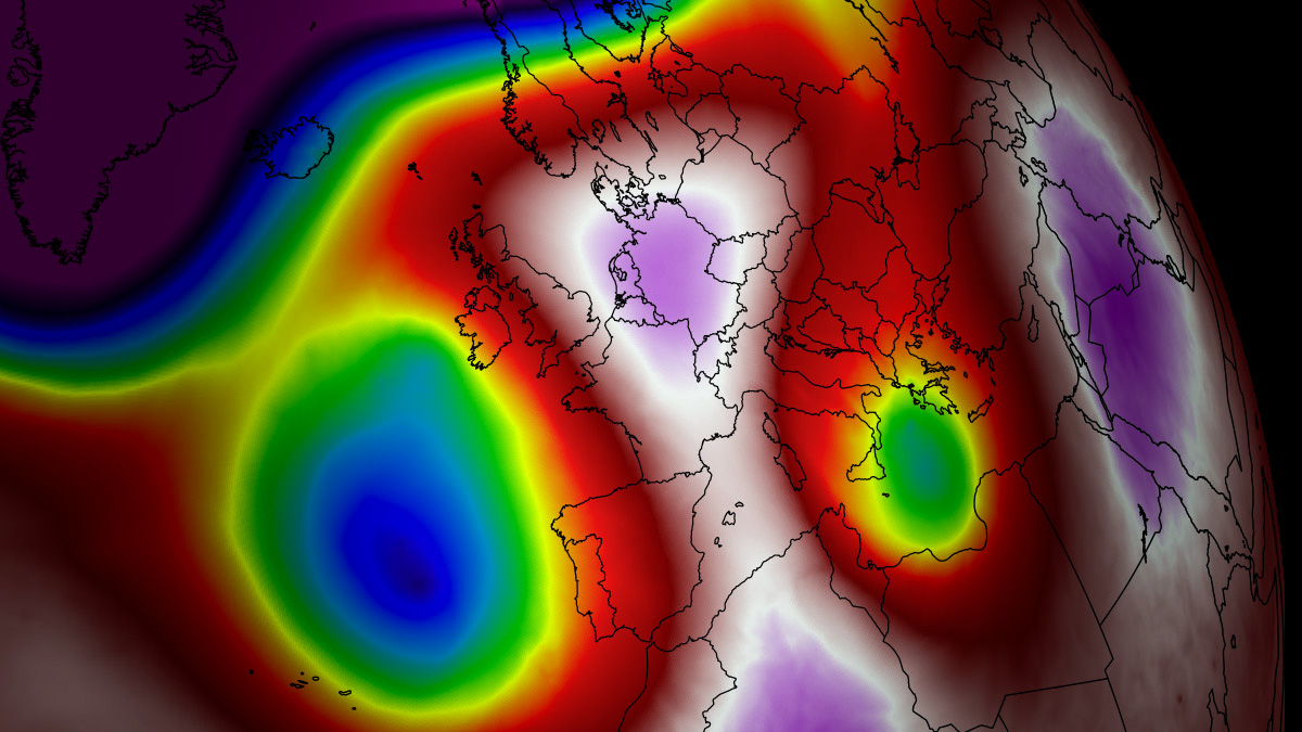
EUROPE — As mid-August unfolds, a powerful and stubborn atmospheric blocking pattern has locked the fifth major Heat Dome of the 2026 season over continental Europe. Driving upper-air thermal anomalies into the 99th percentile, this relentless weather engine is pushing afternoon temperatures past the 40°C (104°F) threshold across vast swathes of France, the United Kingdom, Italy, Central Europe, and the Balkan Peninsula.
Meteorologists warn that this latest thermal surge will not only bring scorching daytime maximums but also inflict prolonged physiological distress via suffocating "tropical nights," straining power grids, exacerbating severe drought, and creating extreme wildfire hazards from the Iberian Peninsula to the Pannonian plains.

Main Facts: The Anatomy of the 5th Heat Dome
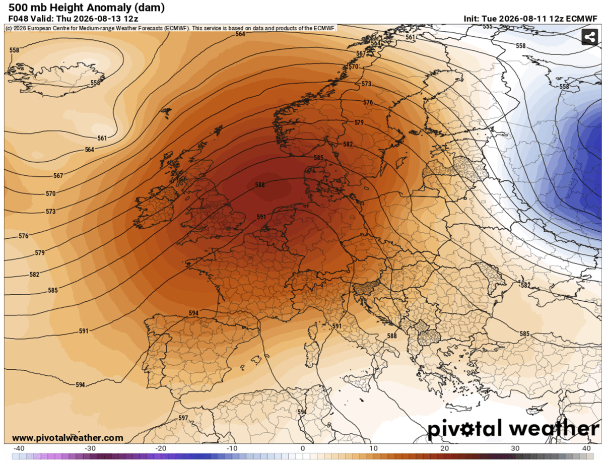
The primary atmospheric driver behind this historic mid-August heatwave is a high-amplitude upper-level high-pressure ridge parked firmly over the heart of the European continent.
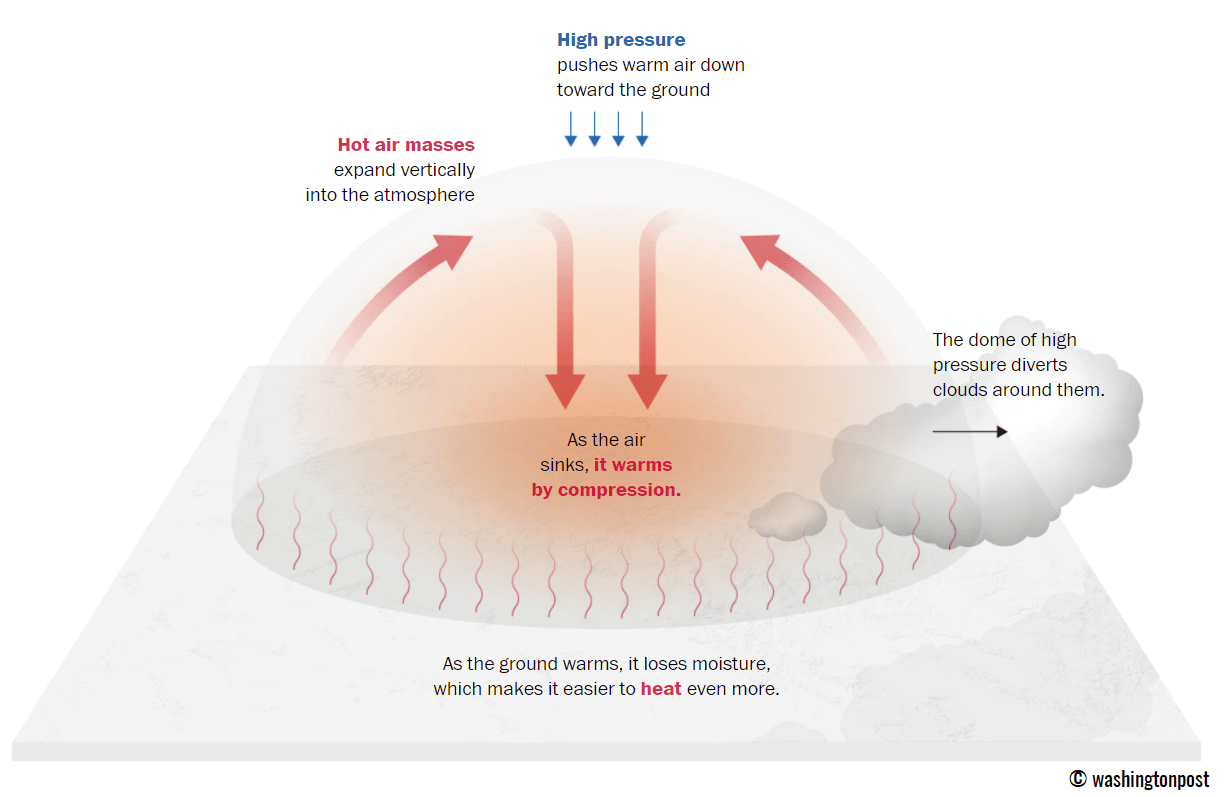
- The Mechanism: Often described metaphorically as a lid on a pot, a heat dome forms when a broad, persistent area of high pressure traps warm air at all levels. As sinking air adiabatically compresses and warms the lower troposphere, low-lying basins and plains experience extreme surface heating.
- Temperature Extremes: Peak afternoon temperatures are forecast to hit 40°C to 44°C (104°F to 111°F) in hardest-hit regions like Spain, France, and parts of Central Europe.
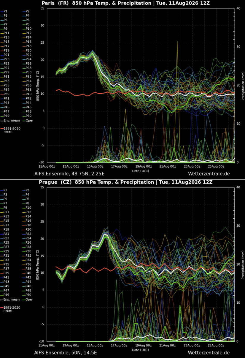
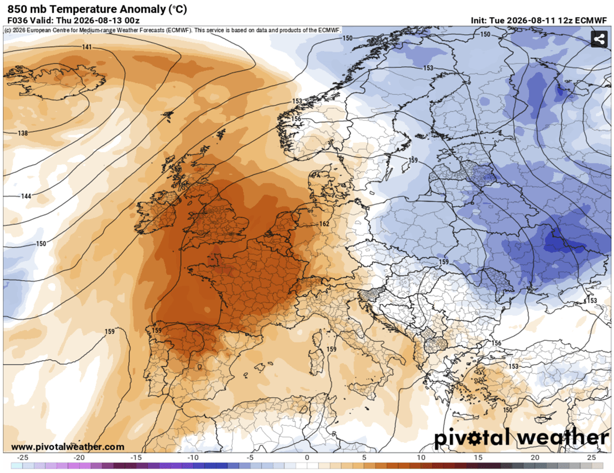
- Thermal Anomalies: Upper-air thermal anomalies at the 850 hPa level are climbing into the 99th percentile, registering 12°C to 16°C above the long-term climatic norms for mid-August.
- Nocturnal Stress: Overnight low temperatures are refusing to drop below 22°C to 26°C (72°F to 79°F) across major urban corridors, denying vulnerable populations the vital physiological cooling window necessary to recover from daytime heat.
Synoptic Setup and Chronology: How the Heatwave Evolves
The progression of this fifth heat dome involves a dynamic shift in the synoptic-scale weather pattern, migrating progressively from Western Europe toward Central and Eastern Europe over the course of the week.
Mid-Week: Western Europe and the UK Feel the Heat
The initial phase of the thermal surge established itself mid-week, fueled by a deep North Atlantic wave that pumped a powerful warm plume far north across Western Europe.
- Portugal and Spain: Heat-prone valleys in southern Spain and portions of south-central Portugal are enduring peak temperatures between 42°C and 44°C.
- France: Northern and southwestern France are bearing the brunt of the mid-week peak, with widespread maximums of 40°C to 43°C.
- The British Isles: On Thursday, the core of the heat dome positioned itself over northern France, the English Channel, and the UK. Southern and central England experienced severe heat, with temperatures skyrocketing to 36°C–39°C, while Ireland recorded unseasonably warm conditions nearing 30°C.
Weekend: Expansion into Central Europe and the Balkans
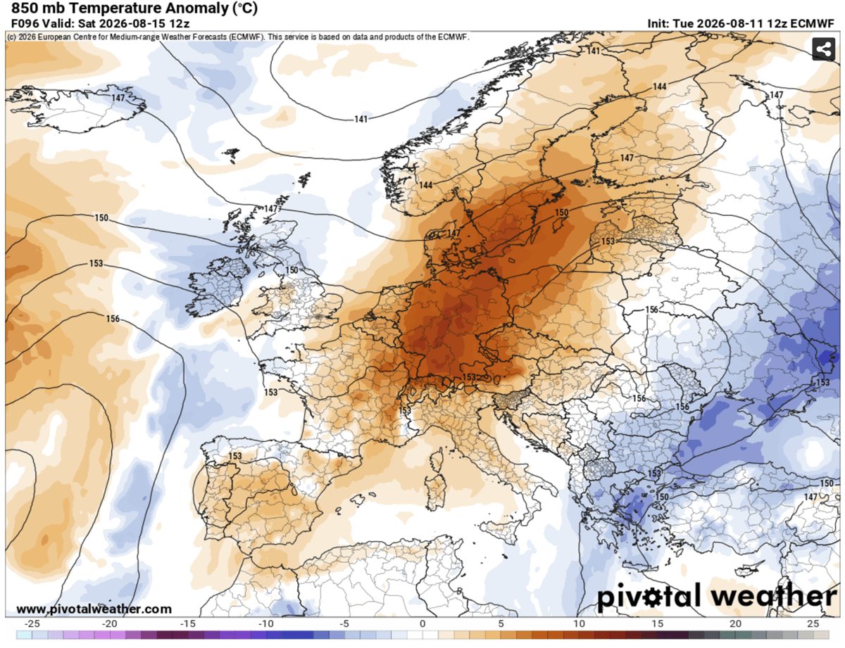
As the upper-level wave over the Atlantic gradually shifts and weakens, the blocking high-pressure ridge will elongate by the weekend. This forces the heat dome to migrate eastward into Central Europe.
- Germany and the Benelux: Following peak temperatures of 36°C to 40°C across Belgium, Luxembourg, and western Germany on Friday, the intense heat expands further east on Saturday and Sunday.
- Poland, Czech Republic, and Scandinavia: Western Poland, the Czech Republic, Denmark, and southern Sweden will see significantly climbing temperatures over the weekend.
- Italy and the Balkans: The Po Valley, Tuscany, eastern Croatia, Hungary, and northern Serbia are bracing for a return of 38°C to 40°C heat as the warm air mass anchors over the Mediterranean and Pannonian basins.
By late Sunday and into the following week, a cooler maritime air mass pushing in from an Atlantic low is projected to finally bring relief, slowly sweeping the excessive heat away from Ireland, the UK, France, and the Iberian Peninsula from west to east.
Supporting Meteorological Data and Dynamics
Understanding the severity of this event requires looking beyond standard thermometer readings into atmospheric physics and indices that measure human impact.
The Science of the Heat Dome
A heat dome relies on an Upper High (or blocking high) that generates persistent sinking air. As this air descends, it compresses, heating up rapidly and clearing the skies of clouds. The lack of cloud cover allows maximum solar radiation to reach the surface, baking dry soils and depleting residual moisture. Dry continental winds further accelerate this process, preventing humidity-based cooling and lowering relative humidity while aggressively drying out vegetation.
The Heat Index and Humidity Factors
Meteorologists emphasize that temperature alone does not tell the full story; humidity plays a critical role in how the human body experiences heat.
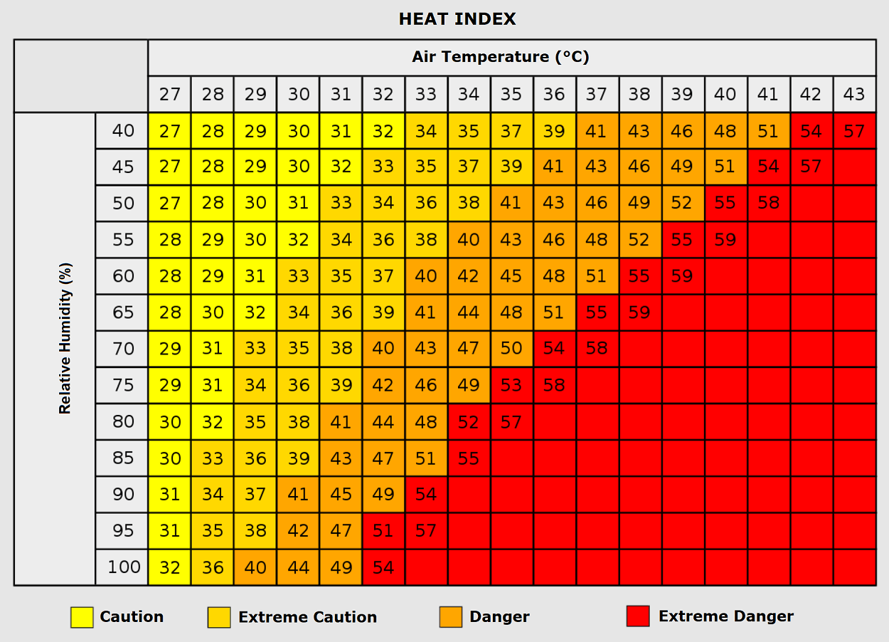
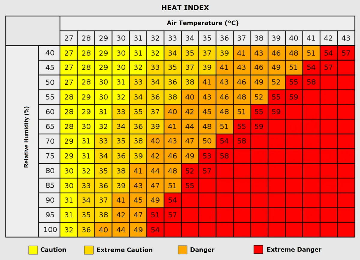
When ambient air temperatures reach 35°C (95°F), a moderate humidity level below 60% is challenging, but manageable. However, if relative humidity climbs above 80%, the apparent temperature—measured by the Heat Index—can surge near 50°C (122°F). This high heat-index environment severely impairs the human body’s primary cooling mechanism: sweat evaporation. Consequently, heatwaves of this magnitude are historically correlated with sharp spikes in heart attacks, strokes, and acute respiratory distress.
Official Responses and Health Implications
As temperatures cross critical thresholds, public health organizations, civil protection agencies, and municipal authorities across Europe have ramped up warnings and emergency protocols.
Public Health Vulnerabilities
Vulnerable demographics face extreme risks during prolonged heat dome events:
- The Elderly and Children: Physiologically less capable of regulating core body temperature, these groups face a drastically heightened risk of heat exhaustion and fatal heatstroke.
- Outdoor Workers: Construction crews, agricultural laborers, and delivery personnel face severe occupational hazards, with prolonged exposure leading to dehydration, dizziness, and renal strain.
- Urban Heat Islands: Impoverished urban populations living in densely packed housing built with heat-trapping materials such as concrete, asphalt, and asbestos endure disproportionately higher indoor temperatures, especially during relentless "tropical nights."
Infrastructure and Energy Grid Pressures
The relentless nature of the heatwave has placed unprecedented strain on European energy grids. The demand for continuous air conditioning in commercial and residential sectors has driven electricity consumption to near-record peaks. Concurrently, cooling water availability for thermal and nuclear power plants has become restricted due to rising river temperatures.
Furthermore, the persistent dry conditions and depleted soil moisture maintain an extreme wildfire risk across southwestern and central Europe, prompting forestry and emergency services to maintain high-alert fire bans and deploy aerial firefighting assets.
Broader Implications and Outlook
The occurrence of this fifth major Heat Dome in a single summer season underscores a rapidly shifting climatic baseline across the European continent. Consecutive intense thermal waves compound environmental stress, causing long-term damage to agricultural yields, lowering navigable river levels for commerce, and accelerating glacier melt in the Alpine regions.
While immediate relief is signaled for the end of the weekend and early next week as a pattern flip introduces cooler maritime air from the Atlantic, climatologists and meteorologists continue to monitor long-term hemispheric trends. As ocean anomalies—including unfolding Pacific and Atlantic patterns—continue to reshape global weather, authorities urge residents across affected nations to heed local meteorological advisories, stay hydrated, and check on vulnerable neighbors until the atmospheric block fully dissolves.
