

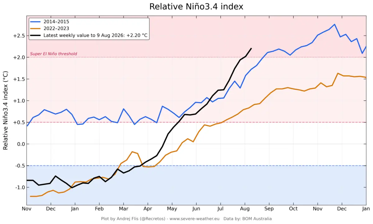
GLOBAL — A powerful and rapidly developing Super El Niño is currently taking shape across the tropical Pacific Ocean, shattering historical benchmarks for speed and intensity. Recent oceanographic and meteorological data confirm that subsurface thermal anomalies and unprecedented westerly wind bursts are supercharging the event. Long-range computer simulations have repeatedly adjusted their peak projections upward, steering the 2026/2027 phenomenon deep into historic territory.

As atmospheric circulation systems lock into a powerful standing wave, meteorologists warn that the consequences will be felt far beyond the tropics. Early seasonal outlooks for the upcoming Fall and Winter seasons reveal a heavily disrupted jet stream poised to reshape weather patterns, storm tracks, and temperature anomalies across the United States, Canada, and Europe.
Main Facts: The Anatomy of a Developing Super Event
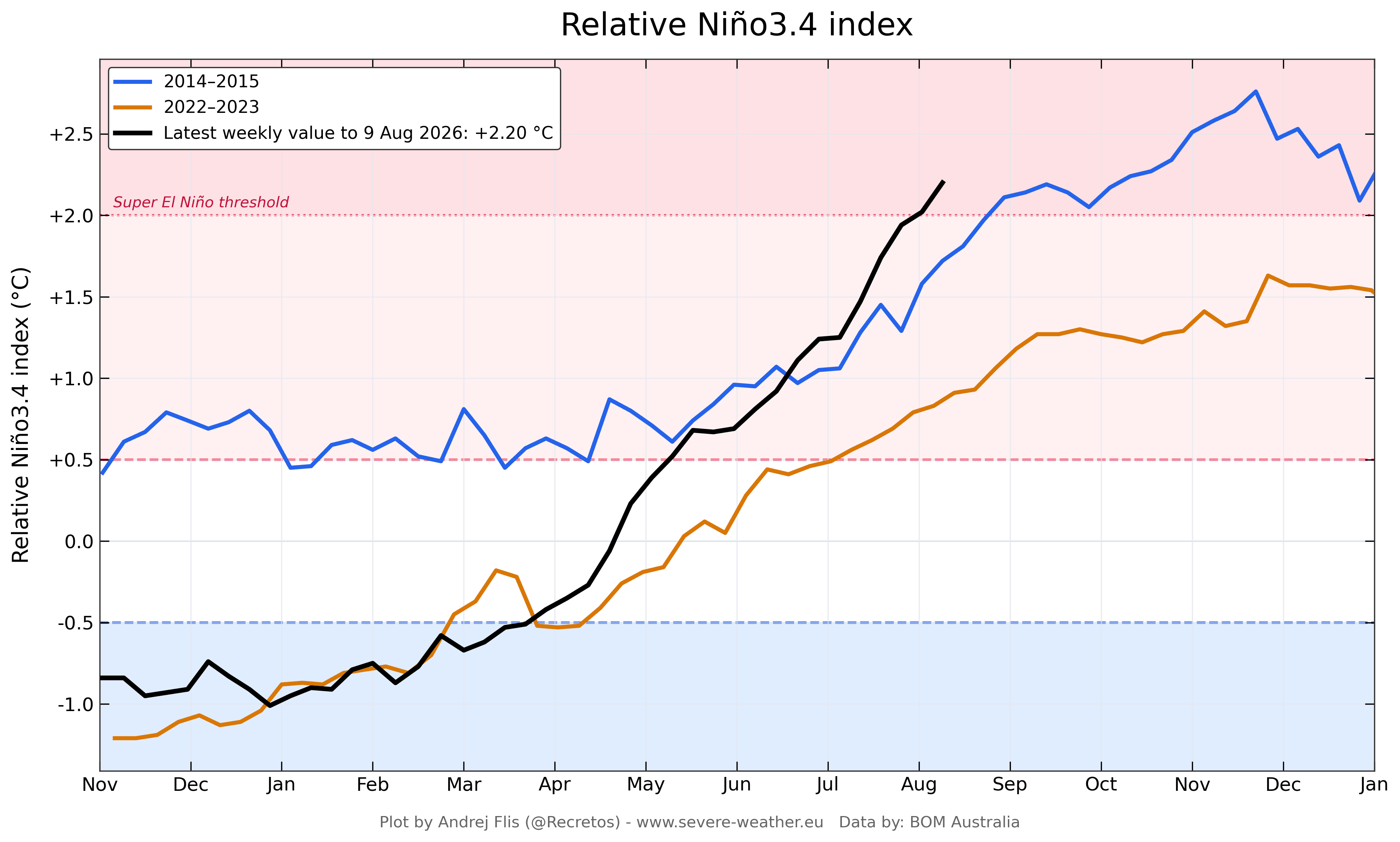
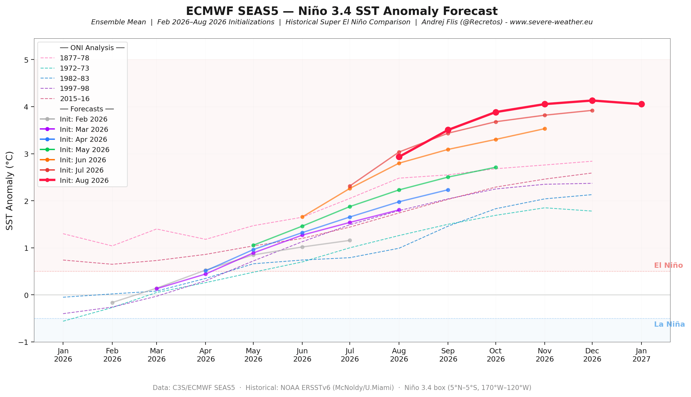
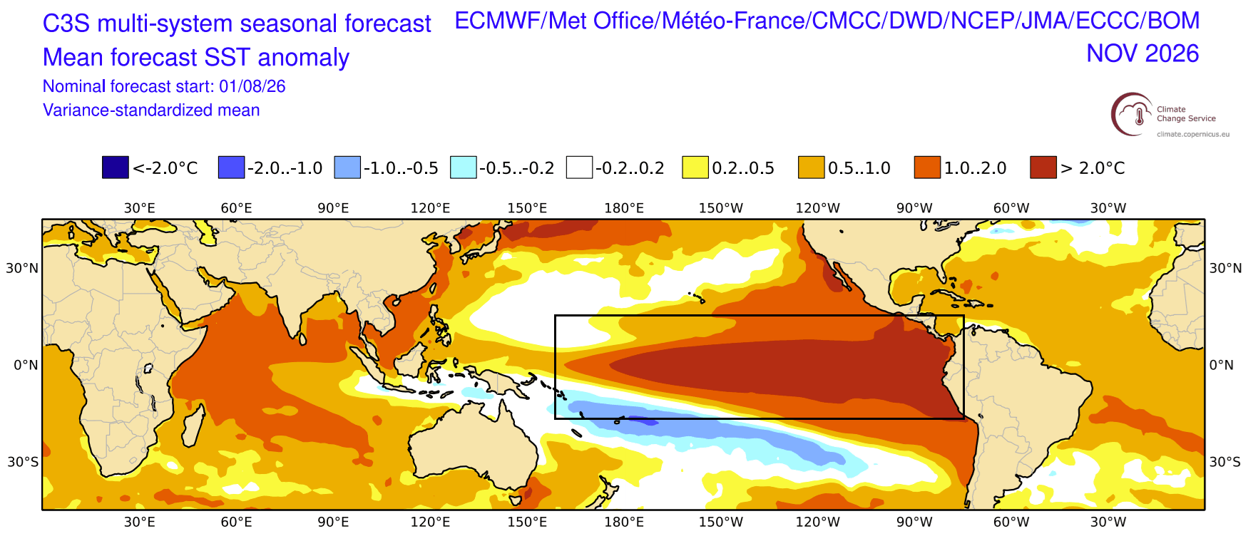
The El Niño-Southern Oscillation (ENSO) is transitioning aggressively into an extreme positive phase. While standard El Niño events occur every few years, "Super" events—characterized by sea surface temperature anomalies reaching or exceeding +2.0°C above the long-term average in the main ENSO region—are rare, typically occurring once a decade or less.
The current 2026 event is bypassing normal developmental timelines. Key metrics underlining the severity of this emerging cycle include:
- Record Subsurface Heat: Downwelling Kelvin Waves are driving enormous pockets of sub-surface warmth eastward through the equatorial Pacific, with temperature anomalies exceeding +9°C (+16°F) in the top 250 meters of the ocean.
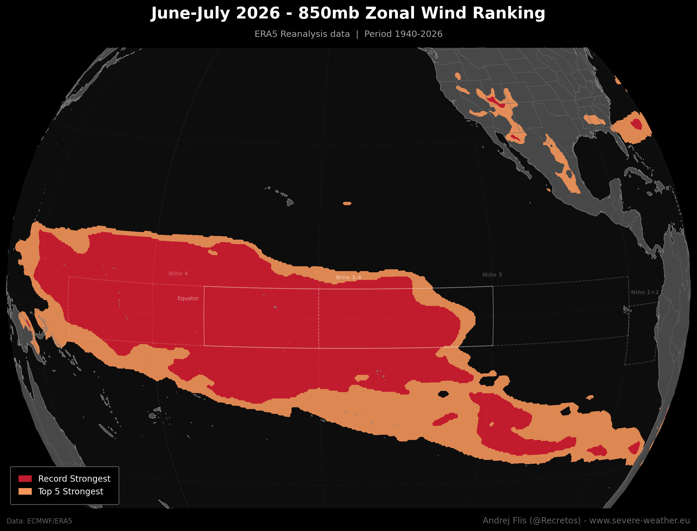
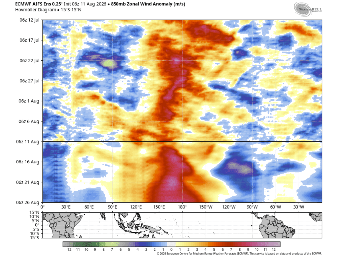
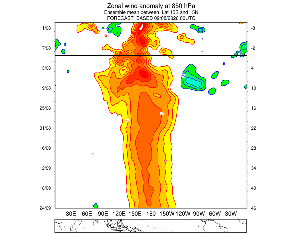
- Unprecedented Wind Anomalies: Low-level westerly wind bursts across the western and central equatorial Pacific have reached levels not seen in an 86-year ERA5 reanalysis dataset.
- Soaring Atmospheric Indices: NOAA’s Multivariate ENSO Index (MEI) recorded an unprecedented June-July (JJ) bi-monthly value of +2.4—the highest for this period since modern records began in 1979. This represents a staggering +3.4-point climb in just four bi-monthly cycles.
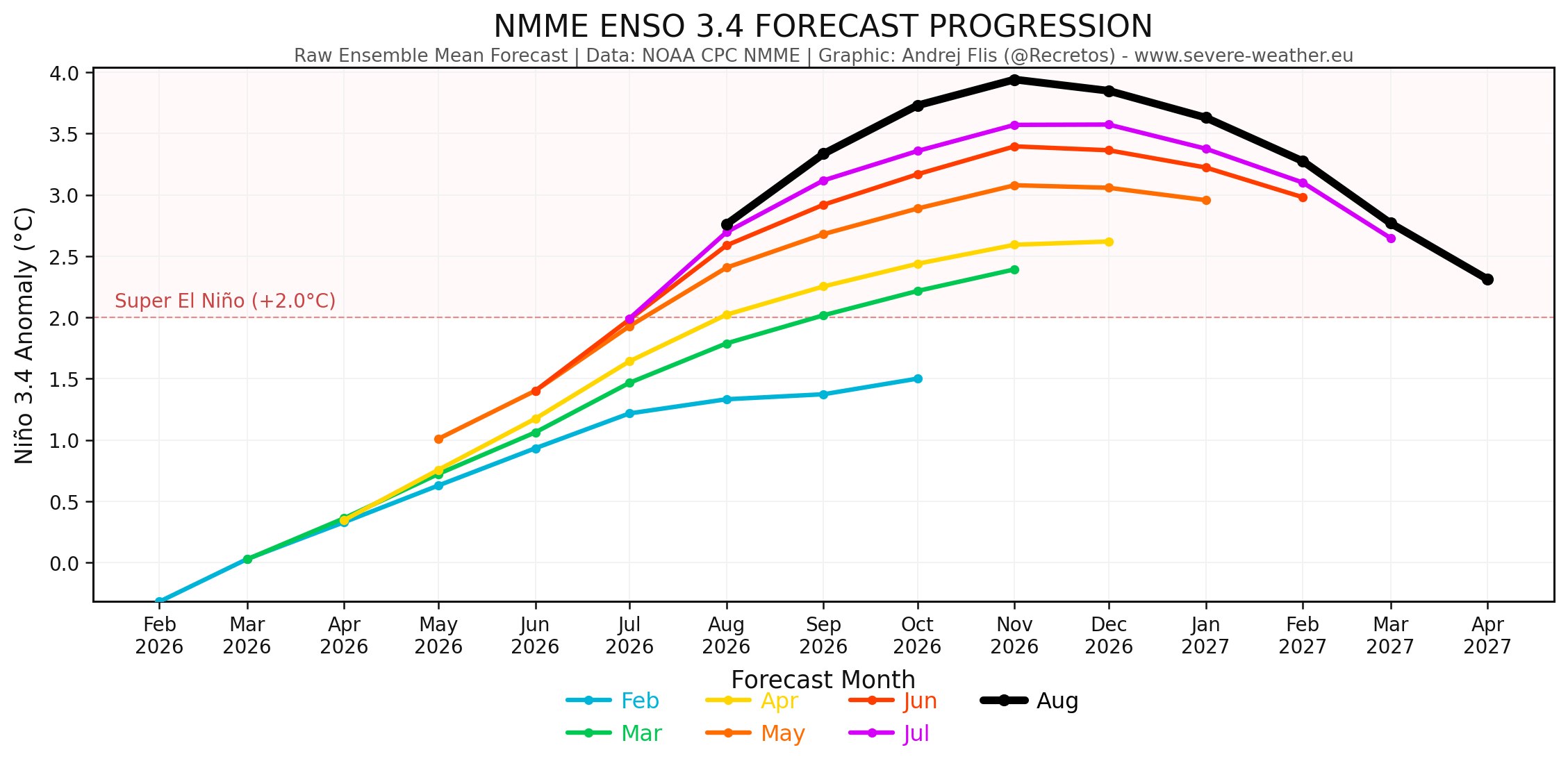
- Model Upgrades: Successive runs from elite forecasting centers, including the European Centre for Medium-Range Weather Forecasts (ECMWF) and the National Multi-Model Ensemble (NMME), show peak projections crossing the +3.0°C threshold, placing the event among the strongest ever recorded.
Chronology of Development: From Spring Acceleration to Late-Summer Surge
The extraordinary trajectory of the 2026 Super El Niño began taking shape during the Northern Hemisphere spring, when anomalous trade wind behavior initiated the first major sequence of westerly wind bursts.
Spring to Early Summer 2026
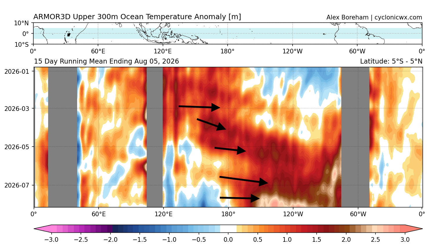
As trade winds collapsed across the western equatorial Pacific, vast quantities of warm water began to pile up. This thermal energy manifested as a deep Kelvin Wave—an oceanic wave traveling eastward along the thermocline. By June and July, zonal wind data captured an exceptional breakdown in normal atmospheric circulation. The collapse of the trade winds was so absolute that it set an 86-year record for low-level westerly anomalies over a two-month average.
Mid-Summer Acceleration
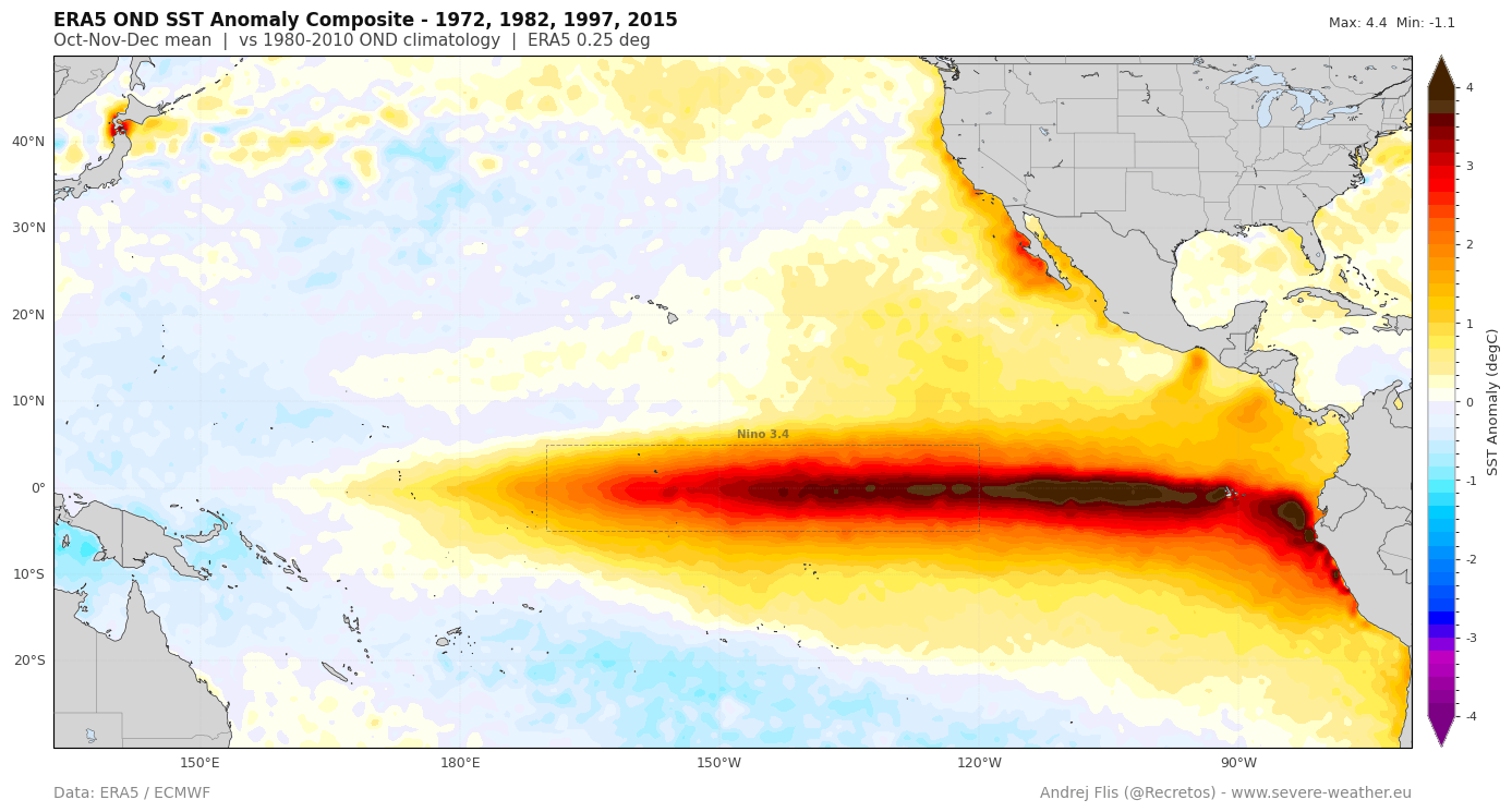
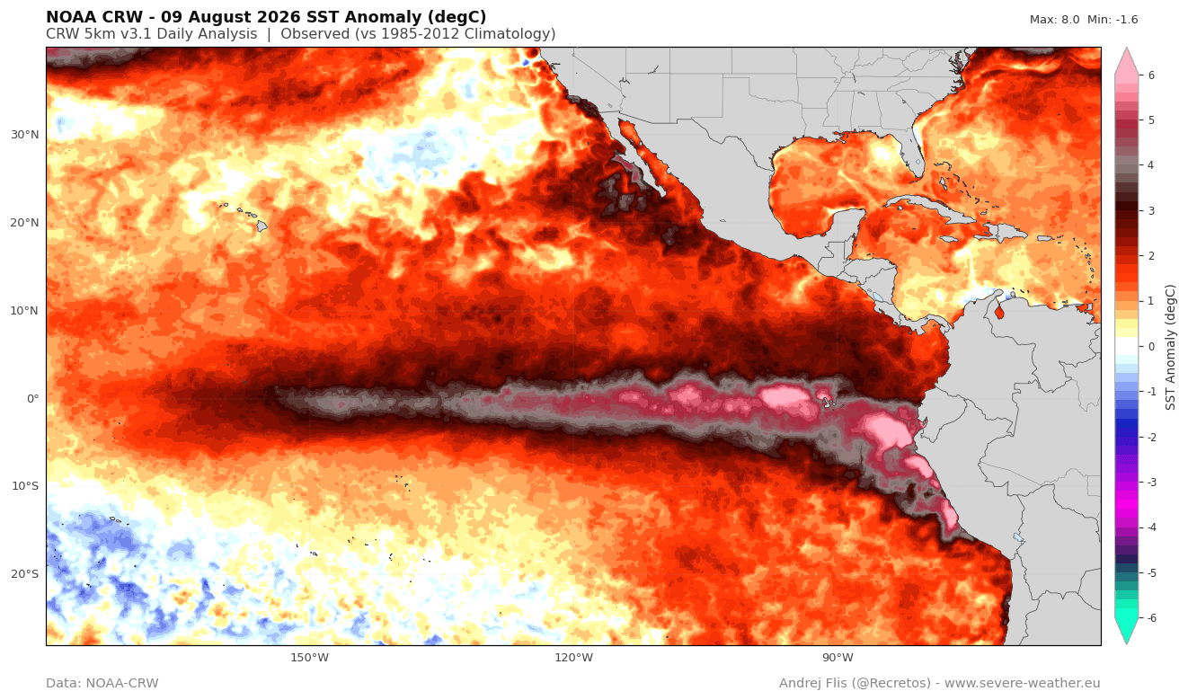
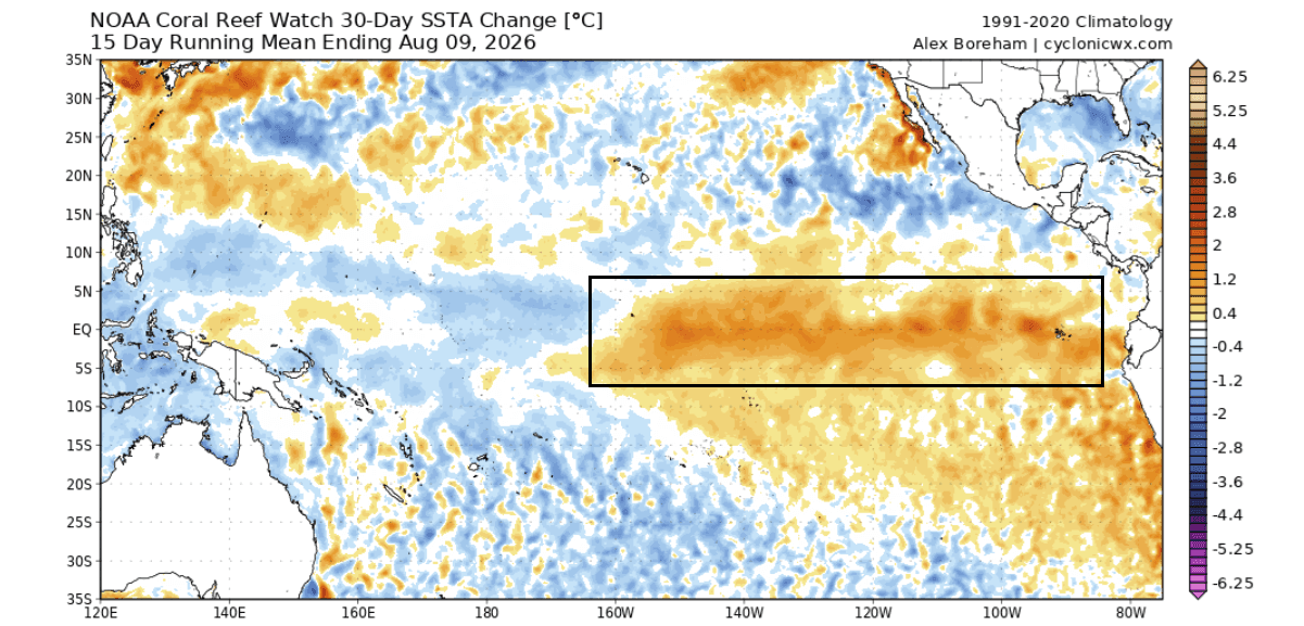
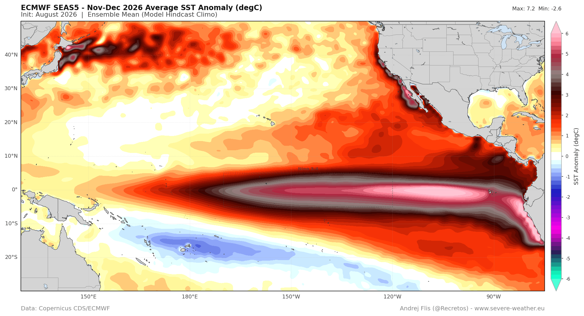
By August, the surface footprint of this subsurface engine became impossible for seasonal models to ignore. Because standard computer models often struggle to simulate individual, high-frequency westerly wind bursts, initial predictions drastically underprojected the event’s early growth. However, as the Kelvin Wave breached the eastern Pacific surface, sea surface temperatures surged, pushing anomalies past +5.0°C in localized eastern sectors and driving a broader 30-day regional warming trend exceeding +1.5°C.
Late Summer Atmospheric Lock
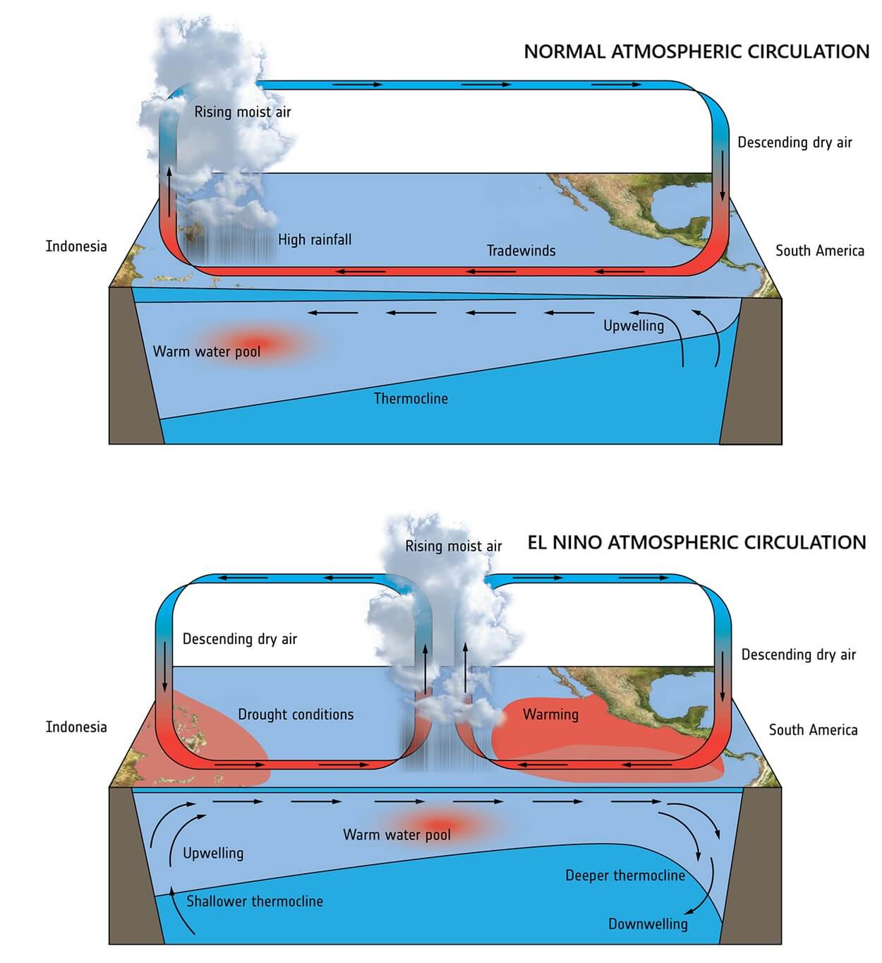
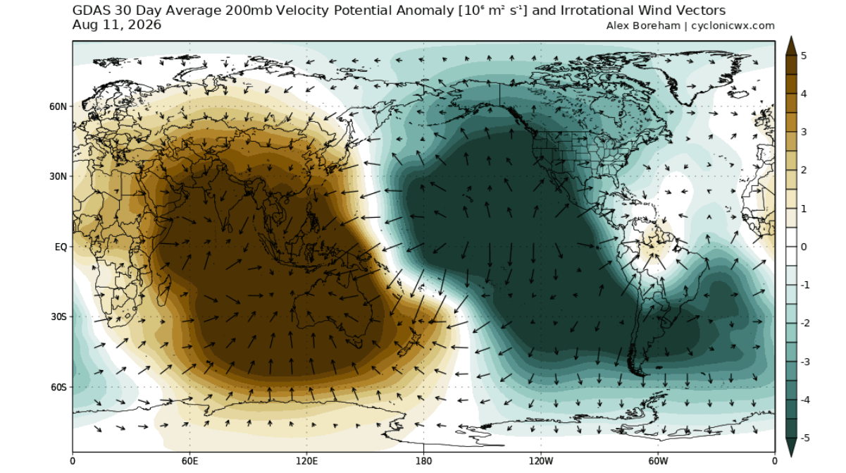
By late August, the scale of the Pacific warming became so immense that it ceased to be a passive oceanic feature, actively forcing the global atmosphere. The traditional Walker Circulation—the tropical loop of rising air in the west and sinking air in the east—became locked in place, establishing a semi-permanent atmospheric standing wave that is dictating global weather patterns months ahead of schedule.
Supporting Data: Oceanic Drivers and Atmospheric Mechanics
Understanding a Super El Niño requires looking far below the ocean’s surface. While surface temperatures capture public attention, the true power of the event lies in the ocean heat content down to 300 meters (1,000 feet).
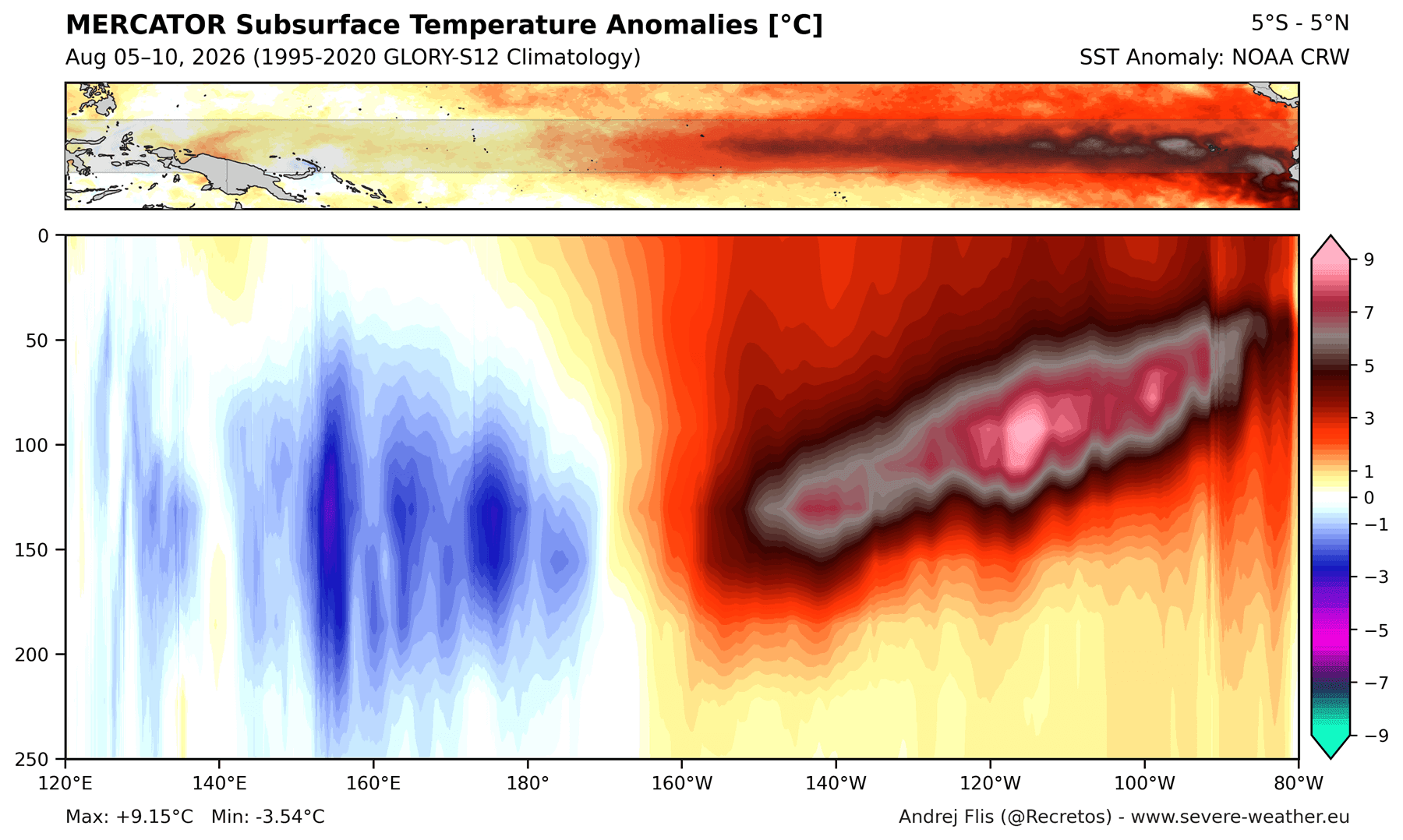
The Kelvin Wave Engine
Continuous westerly wind bursts act as a physical piston, shoving warm surface waters eastward and depressing the thermocline in the central Pacific while lifting warm subsurface water in the east. The latest NOAA Coral Reef Watch (CRW) and ECMWF data reveal that this mechanism is operating with an energy signature that eclipses both the 2015–2016 and 1997–1998 Super El Niño events at comparable stages.
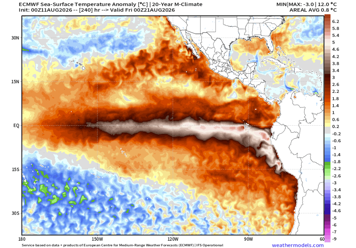
The ECMWF 10-day forecasts project an ongoing expansion of the vast +5.0°C (+9.0°F) anomaly region. This guarantees a continuous supply of thermal energy to sustain the El Niño well into the winter months.
Atmospheric Teleconnections and the Walker Cell
In a neutral or moderate year, tropical rising and sinking motion shifts dynamically. However, the sheer thermal magnitude of the 2026 Super El Niño creates a rigid atmospheric feedback loop. GDAS Velocity Potential data from July and August illustrate a massive, stationary rising-air anomaly directly over the central and eastern Pacific, paired with stable, suppressed sinking air over the Indian Ocean.
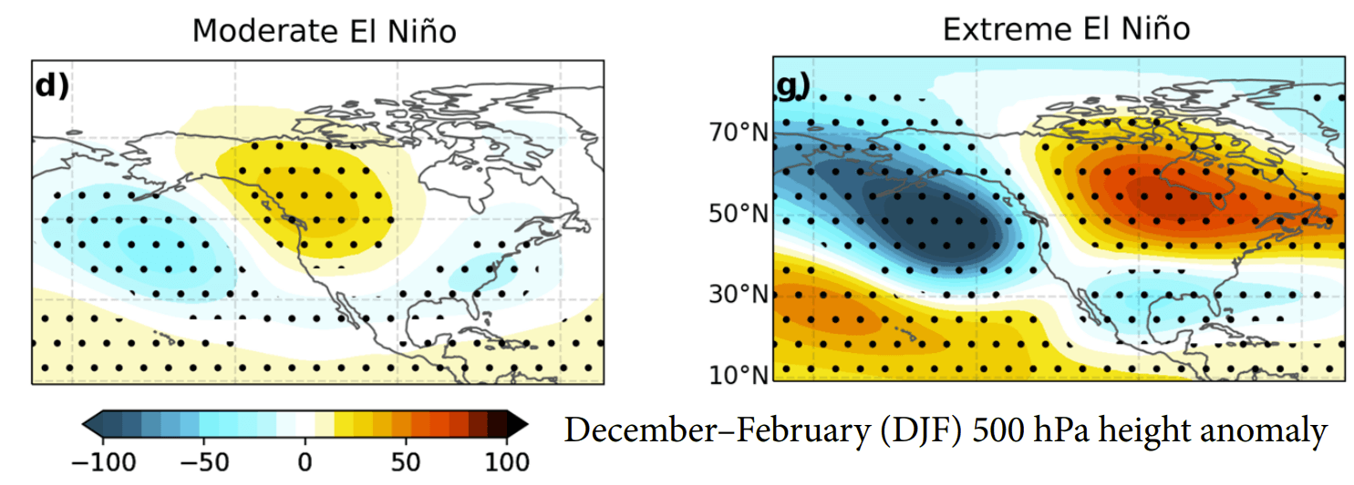
This global standing wave alters the planetary-scale jet stream, forcing a deep trough over the North Pacific and a pronounced high-pressure ridge over western Canada.
Official Responses and Long-Range Forecast Implications
Meteorological agencies worldwide, including NOAA, the Australian Bureau of Meteorology (BOM), and the ECMWF, are closely monitoring the cascading global impacts of this historic event. Because the atmosphere is responding with unusual speed, early-season forecasts are already displaying characteristics normally reserved for deep winter.
Fall 2026: An Early Winter Transition
Typically, autumn acts as a transition phase where El Niño impacts are still developing. However, the 2026 Fall forecast (covering October through December) displays an advanced, highly evolved signature:
- North America: A robust high-pressure anomaly takes root over Canada, paired with a Pacific low and an active storm track across the southern United States. Temperatures are projected to run near-normal to slightly above average across the northern tier, while increased precipitation and heavy storm potential target the southern U.S., Southeast, and Mid-Atlantic.
- Europe: Downstream teleconnections from a North Atlantic low-pressure extension will introduce a dominant westerly and southwesterly flow. This setup favors a milder-than-average autumn across central, western, and southeastern Europe, accompanied by above-normal precipitation.
Winter 2026/2027: Amplified North American Pattern
As the Super El Niño approaches its climatological peak between November and December 2026, the winter atmospheric configuration will take center stage.
- The United States and Canada: The classic El Niño "atmospheric highway" will be in full effect. Deep low-pressure systems over the North Pacific and southern United States will interact with Canadian blocking ridges. While the Pacific Northwest, northern Plains, and western Canada experience milder, drier conditions, the southern tier and East Coast face an active, stormy regime.
- Mid-to-Late Winter Shifts: Emerging CFSv2 and ECMWF data for February 2027 hint at a potential eastward shift in the primary pressure wave. If northern blocking intensifies as projected, a colder-than-normal airmass could bleed southward into the central and eastern United States, setting the stage for high-impact winter storm and heavy snowfall scenarios across the Midwest, Mid-Atlantic, and interior Northeast.
- Snowfall Outlook: Reduced snow totals are expected across the Pacific Northwest and southern Canada. Conversely, the central and eastern United States—particularly areas where the southern jet stream intersects periodic drops of polar air—face an elevated risk of significant winter storms, ice events, and heavy snowfall anomalies.
Europe Winter 2027 Outlook
For Europe, the winter pattern is heavily dictated by North American pressure anomalies extending downstream. The ECMWF December–February outlook points to low-pressure extensions dominating northern and northwestern Europe. This maintains a robust westerly Atlantic flow, translating into a predominantly mild winter season for much of the continent. Broad snowfall anomalies will likely be restricted to the far north, northeast, and higher central mountain elevations, while individual Atlantic storms bring heavy rain and wind to coastal regions.
Global Implications and Looking Ahead
The unfolding 2026/2027 Super El Niño is more than a regional climate anomaly; it is a profound reset of the global climate system. By injecting record amounts of thermal energy into the atmosphere and locking the Walker Circulation into a stationary state, this event has thrown out the traditional playbook for seasonal forecasting.
As scientists continue to ingest real-time observational data from buoy networks, reanalysis models, and satellite telemetry, the focus turns to how agriculture, infrastructure, and energy markets will adapt to the stark polarization of weather extremes. From enhanced storm tracks across the southern United States to mild, wet conditions across Europe, the ripple effects of this historic Pacific event will dominate the global meteorological landscape well into the coming year.
