

EUROPE — Meteorological authorities have issued urgent warnings for a major, multi-day severe weather outbreak sweeping across portions of the western and northern Mediterranean. A potent combination of unseasonably extreme marine heat, deep upper-level dynamics, and robust wind shear is converging to create a volatile atmospheric setup.
Forecasters anticipate widespread, destructive thunderstorm activity beginning Wednesday morning, September 9, and persisting through Friday afternoon, September 11, 2026. The severe weather threat zone spans from the Balearic Islands across southern France, northern Italy, Slovenia, Croatia, and down into the central Adriatic region.
Main Facts: The Anatomy of an Extreme Weather Event
The incoming severe weather outbreak is driven by a clash of large-scale meteorological forces. A deep, expansive upper-level trough has emerged over Western Europe and is tracking eastward. Simultaneously, a robust blocking high-pressure system positioned to the east is collapsing as it migrates into Eastern Europe.

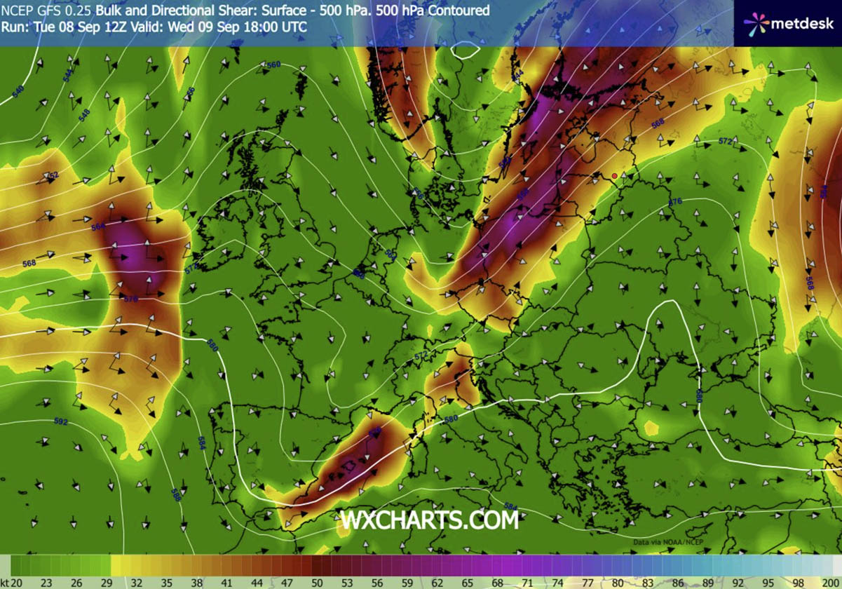
Between these contrasting systems, a powerful southwesterly jet stream is establishing itself, injecting intense wind shear into the lower and middle troposphere. Beneath this dynamic jet stream lies an uncommonly warm and humid air mass, heavily fueled by a historic marine heatwave that has persisted across the Mediterranean basin.
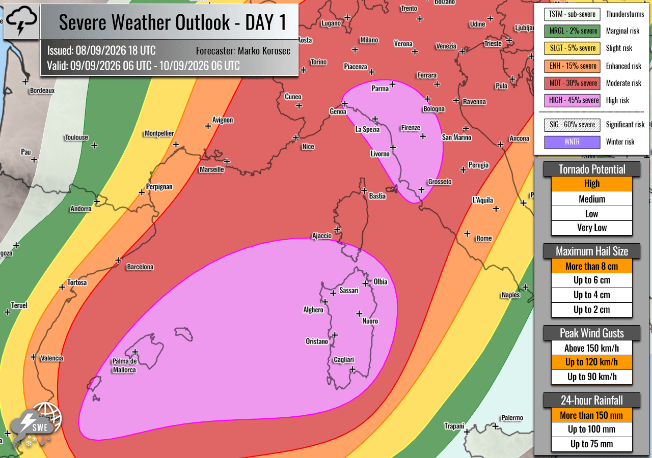
- Primary Hazards: Giant to exceptionally large hail (ranging from 6 to 10 cm or larger), destructive straight-line winds, tornadoes (including the potential for strong, low-level rotation), and catastrophic flash flooding.
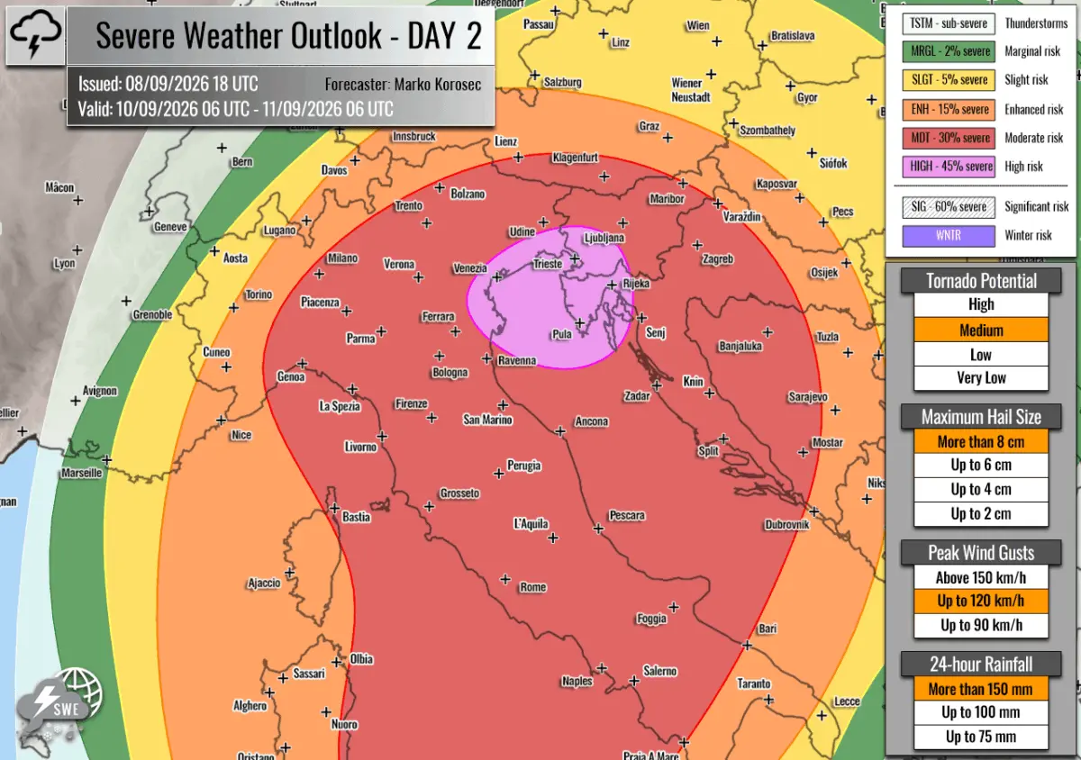
- Risk Designations: HIGH and Moderate (MDT) risks have been officially issued for vulnerable coastal and inland zones across the Western and Northern Mediterranean.
- Target Regions: The Balearic Islands, southern Corsica, Sardinia, Liguria, Tuscany, northeastern Italy, western Slovenia, and northwestern Croatia.
According to severe weather analysts, the presence of dewpoints near or exceeding 25°C will generate moderate to extreme atmospheric instability. Mixed-Layer Convective Available Potential Energy (MLCAPE) values are forecast to skyrocket between 3,000 and 4,000+ Joules per kilogram (J/kg) across portions of the target zones, providing virtually unlimited energy for explosive storm development.
Chronology of the Outbreak: Day-by-Day Progression
The multi-day convective event will evolve rapidly, shifting from west to east as a sharp cold front races across the continent and into warm Mediterranean waters.
Wednesday, September 9: The Balearic Islands and Western Italy Ignited
The outbreak kicks off early Wednesday morning over the Balearic Islands, the Ligurian Bay, and northwestern Italy. As the cold front approaches from the west, intense low-level southerly winds will pump moisture inland, colliding with strong upper-level forcing.
- Morning to Early Afternoon: Isolated, highly volatile supercells are expected to develop rapidly over the Balearic waters and eastern Spain, tracking northeastward. These initial storms will carry threats of very large to giant hail and destructive winds.
- Late Afternoon and Evening: Storm clusters will approach southern Corsica, Sardinia, and the western coast of Italy. The Ligurian and Tuscan coastal areas are flagged for a heightened tornado threat due to localized low-level directional shear. Furthermore, slow-moving storm cells will begin dumping torrential rain over interior hillsides, setting the stage for localized flash floods.
- Nighttime Hours: Convective activity will upscale into large clusters, sweeping across northern Italy and approaching western Slovenia and northwestern Croatia by late evening. Damaging straight-line winds and torrential rainfall will remain the primary nocturnal threats.
Thursday, September 10: The Focus Shifts to the Northern Adriatic and Balkans
By Thursday, the primary axis of severe weather shifts eastward, targeting northeastern Italy, the northern Adriatic Sea, western Slovenia, and northwestern Croatia.
- Daytime Dynamics: Widespread thunderstorm activity from the overnight hours will be reinforced by daytime heating and continuous moisture advection from the Adriatic and Tyrrhenian seas. Slow-moving multicell storms and discrete supercells will dominate the early hours before consolidating into massive linear convective systems by the afternoon.
- The Flash Flood Crisis: Thursday’s primary danger shifts toward cumulative rainfall totals. Because storms are expected to "train" (move repeatedly over the same locations), precipitation accumulations could easily reach 200 to 300 mm within a compressed 36-hour window.
- Continued Hazards: Alongside the severe flooding threat, the region remains at high risk for embedded supercells capable of producing damaging winds, large hail, and tornadoes.
Supporting Data and Meteorological Parameters
To understand the severity of this forecast, meteorologists point to several critical atmospheric indices derived from high-resolution global and regional forecasting models, including data processed by PivotalWeather:
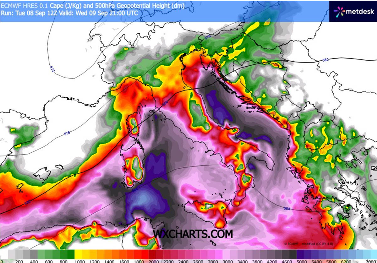
- Extreme CAPE Values: MLCAPE readings exceeding 3,000 J/kg over maritime and coastal areas indicate extreme buoyancy. When coupled with steep mid-level lapse rates, updrafts within storms can reach phenomenal velocities, easily suspending large ice accumulations to produce giant hail.
- Deep-Layer and Low-Level Wind Shear: The intense left exit region of the mid-level jet stream will maximize vertical wind shear. Storm-relative helicity values near the Balearic Islands and the Ligurian coast will be exceptionally favorable for rotating updrafts, increasing the probability of tornadogenesis.
- Precipitable Water and Antecedent Conditions: Unseasonably warm sea-surface temperatures mean the atmosphere is saturated with moisture. In areas suffering from prolonged drought conditions, the ground has lost much of its natural permeability, drastically lowering the threshold for dangerous flash flooding and mudslides once rainfall rates surpass 50 mm per hour.
Official Responses and Public Safety Directives
Emergency management agencies, civil protection directorates, and meteorological offices across Spain, France, Italy, Slovenia, and Croatia have placed their respective teams on high alert.
- Spain: Civil protection authorities in the Balearic Islands have issued advisories urging residents and tourists to secure outdoor property, avoid maritime activities, and stay away from coastal promenades as violent winds and rough seas develop.
- Italy: The Italian Department of Civil Protection has issued yellow, orange, and red weather alerts for Liguria, Tuscany, and the Po Valley. Local municipalities have begun inspecting drainage systems and preparing emergency response units for potential urban flooding and structural damage caused by high winds.
- Balkan Nations: Slovenian and Croatian hydrological services are closely monitoring river levels in anticipation of rapid runoff from the Julian Alps and surrounding elevated terrain. Residents living in flood-prone valleys have been advised to prepare for potential evacuation orders should flash flood warnings be upgraded.
Broader Implications: Climate Trends and Infrastructure Vulnerability
This severe weather event highlights a growing, concerning trend across the European continent: the intensification of Mediterranean weather systems driven by abnormally warm sea temperatures. Marine heatwaves act as thermal engines, pumping excessive latent heat and moisture into the lower troposphere. When these heat-laden waters interact with dynamic cold fronts plunging from Northern Europe, the resulting atmospheric release can be explosive.
Furthermore, the juxtaposition of prolonged regional drought followed by catastrophic, concentrated rainfall poses a severe test to modern civil infrastructure. Urban environments, agricultural lands, and outdated drainage networks struggle to cope with hundreds of millimeters of rain falling in less than two days.
As the climate continues to warm, meteorological organizations emphasize that early preparedness, accurate high-resolution forecasting, and robust public response mechanisms will be critical in mitigating loss of life and property during such high-impact convective outbreaks. Residents within the designated HIGH and MDT risk zones are strongly advised to monitor local weather alerts continuously and heed all instructions issued by civil authorities through Friday afternoon.
