

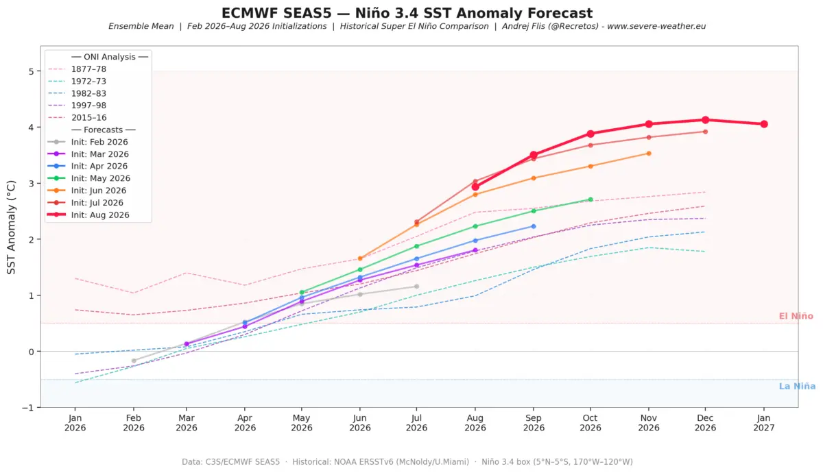
As the meteorological community turns its eyes toward the colder months, the incoming Winter 2026/2027 season is rapidly crystallizing around a dominant, high-impact climatic driver: a rapidly developing Super El Niño. Recent oceanographic data and multi-model seasonal simulations from leading global forecasting institutions point definitively toward an extreme-threshold event.

This comprehensive analysis synthesizes ocean heat content, historical analog winters, stratospheric Polar Vortex dynamics, and regional forecasts for the United States, Canada, and Europe. Backed by cutting-edge telemetry from the European Centre for Medium-Range Weather Forecasts (ECMWF), the National Oceanic and Atmospheric Administration (NOAA), and the UK Meteorological Office (UKMO), this outlook examines how a historic tropical ocean anomaly will translate into severe, highly differentiated weather patterns across the Northern Hemisphere.
Main Facts: The Anatomy of a Super El Niño
The fundamental catalyst for the upcoming winter is taking shape deep within the tropical Pacific Ocean. Global weather systems are responding to an extraordinary buildup of sub-surface and surface thermal energy.
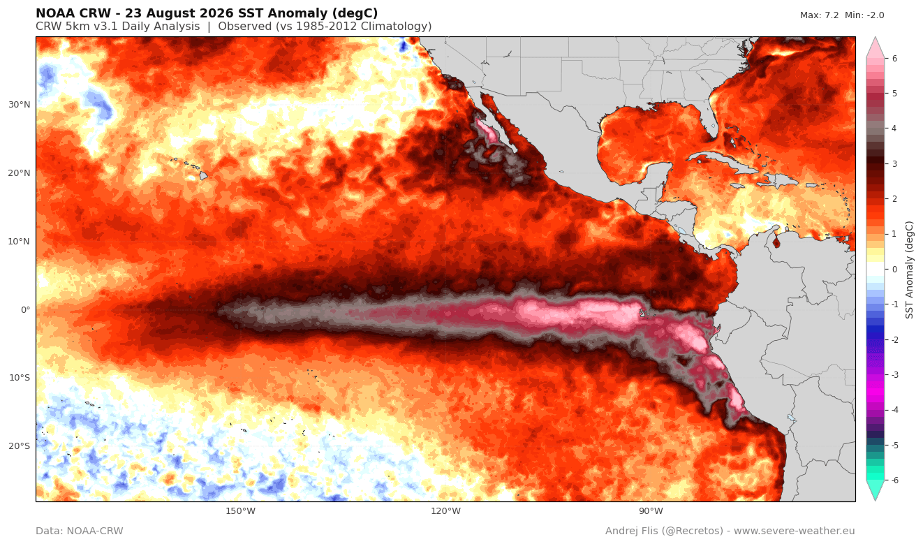
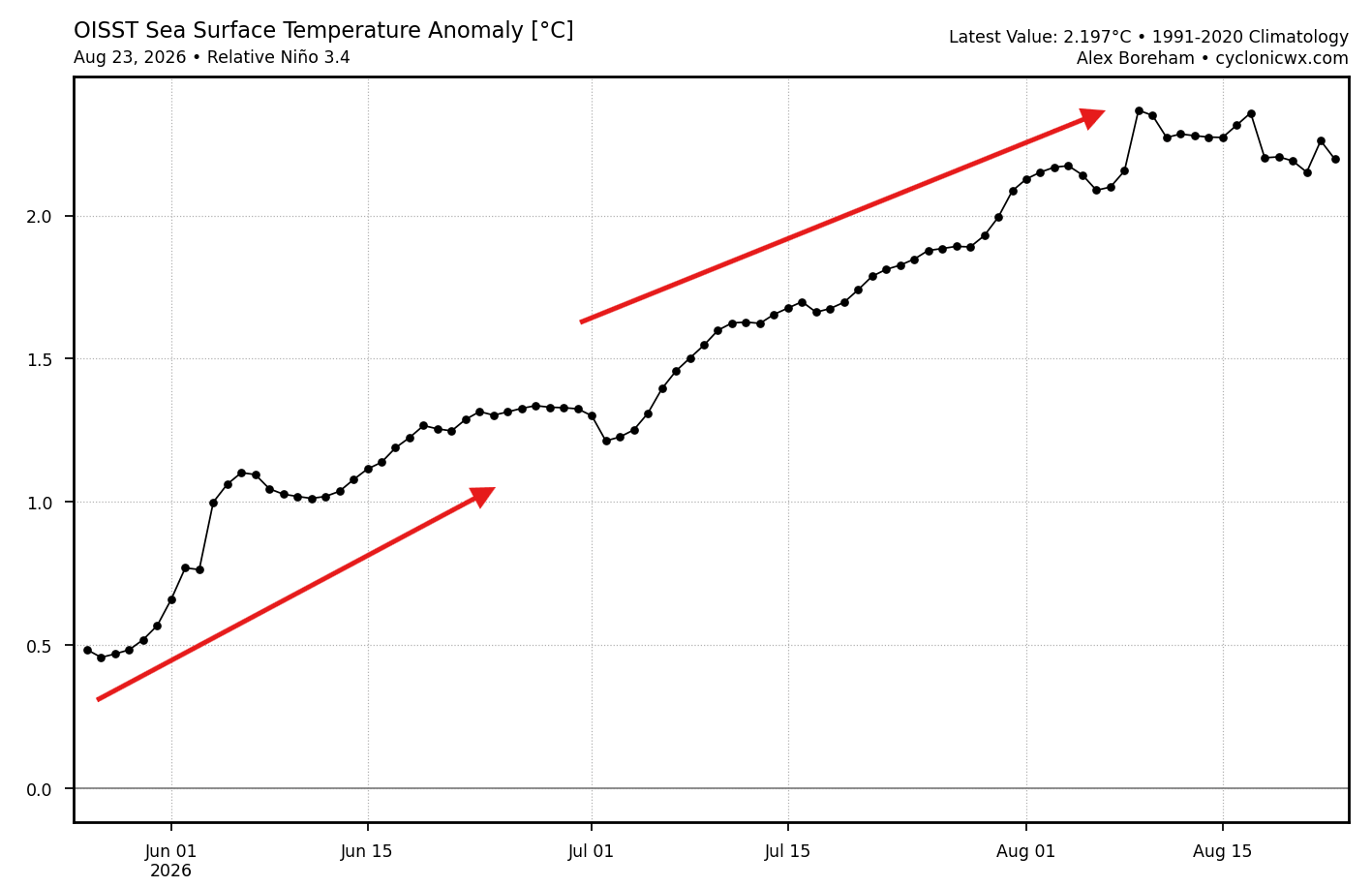
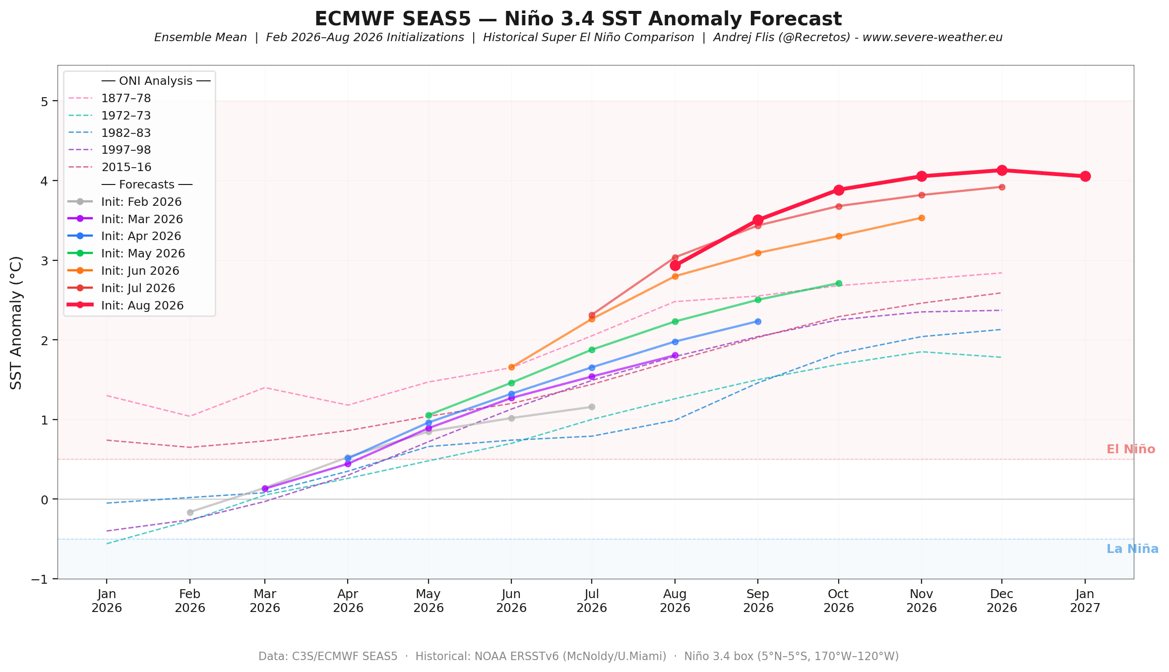
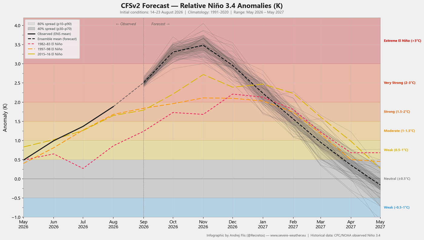
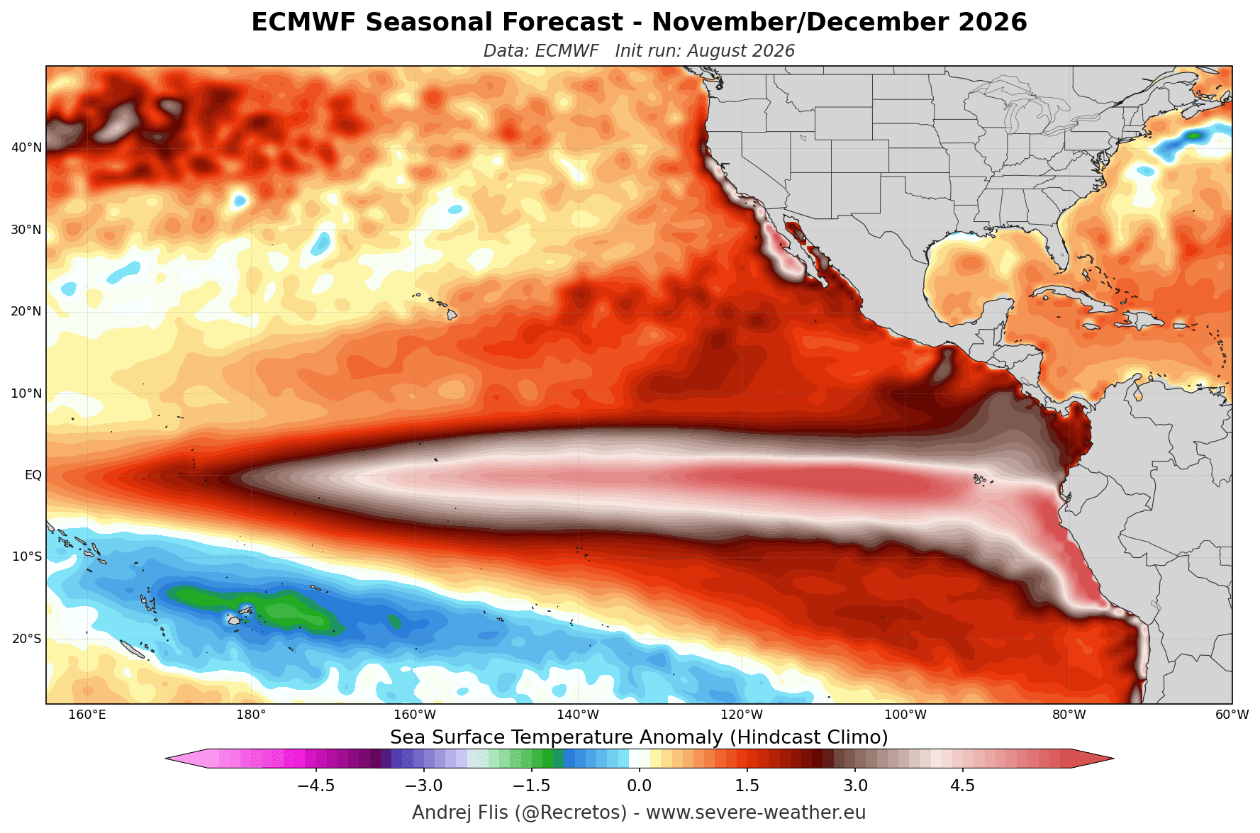
- Extreme Threshold Crossed: Seasonal forecasts confirm that equatorial sea surface temperatures have shattered the baseline criteria for a standard El Niño, pushing firmly into Super El Niño territory with sustained anomalies exceeding +2°C, and projected peaks threatening to cross the +3°C threshold.
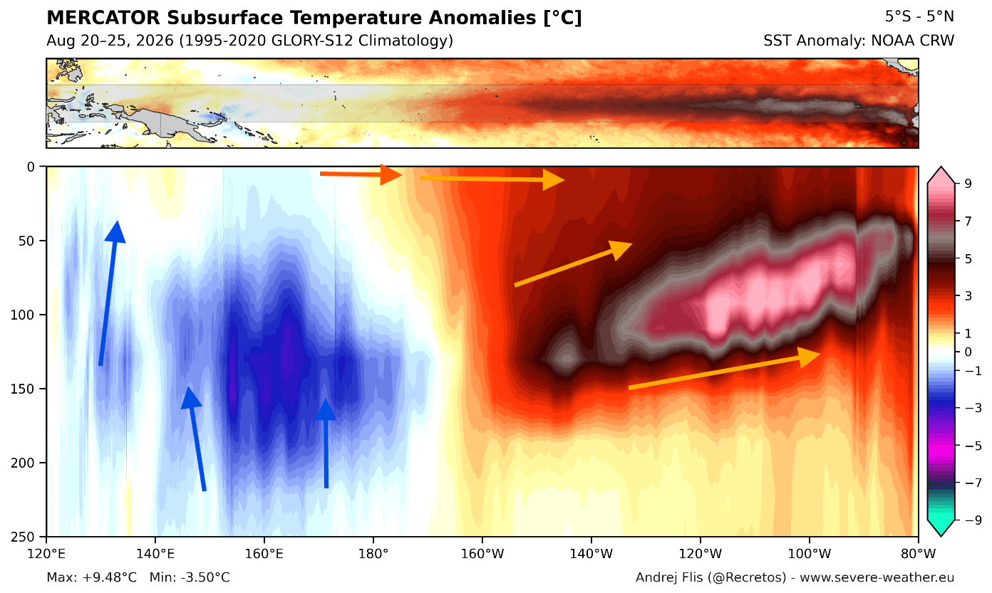
- The Kelvin Wave Engine: Subsurface analysis using NOAA Coral Reef Watch (CRW) and OISST data reveals a massive downwelling Kelvin wave. In the upper 250 meters (800 feet) of the tropical Pacific, subsurface temperature anomalies are surging at more than 9°C (16°F) above normal.
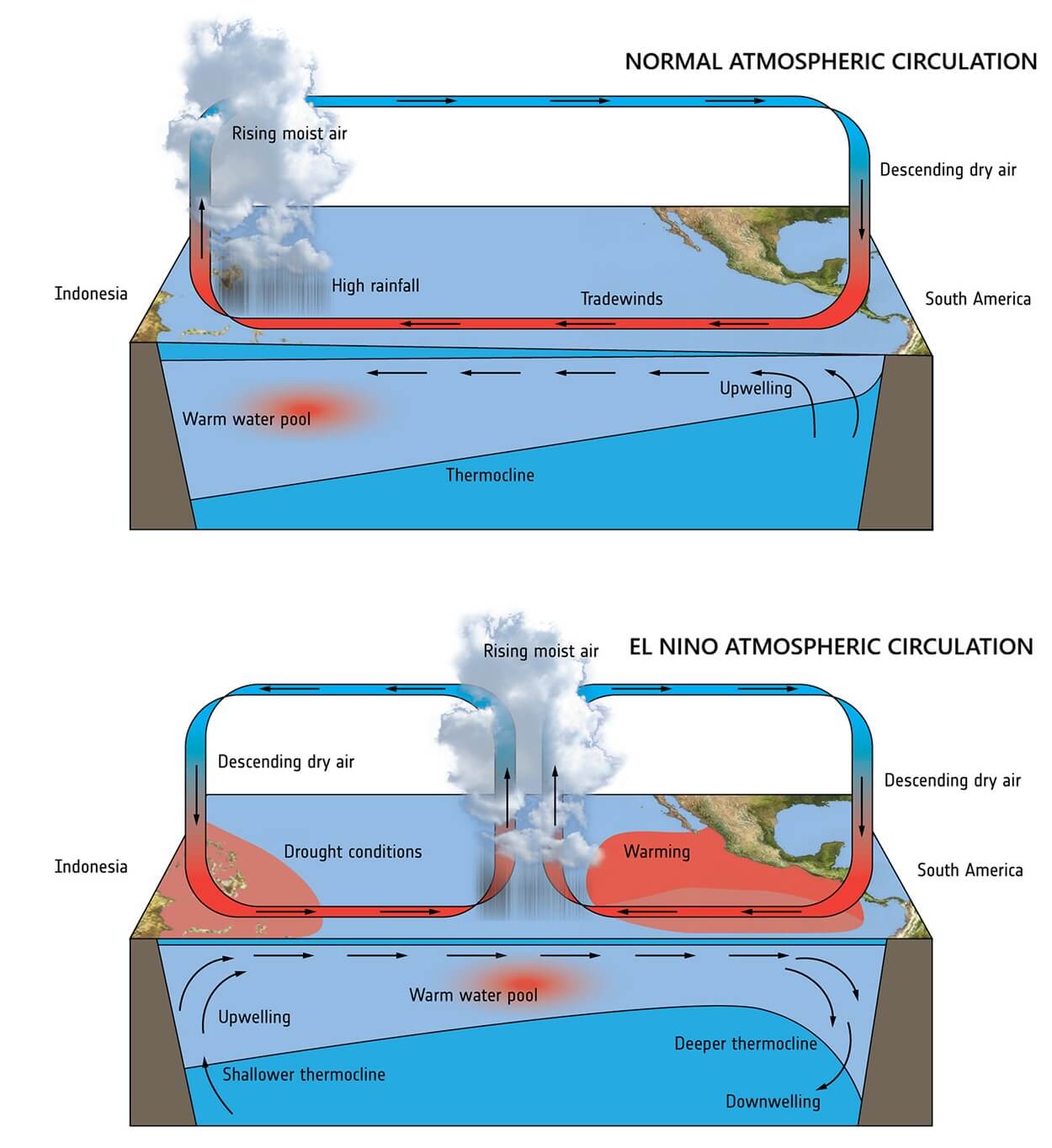
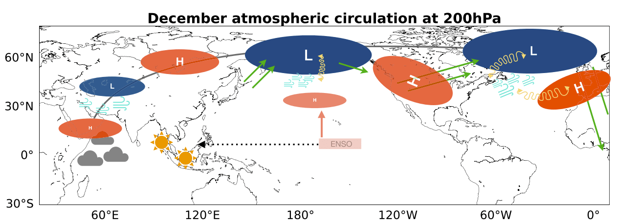
- The Walker Cell Disruption: This massive pool of warm water alters the Walker Circulation—the tropical atmospheric overturning cell—lowering surface pressure over the central and eastern Pacific while reinforcing high pressure in the west. This dynamic launches planetary-scale Rossby wave trains across both hemispheres, completely reshaping the global jet stream.
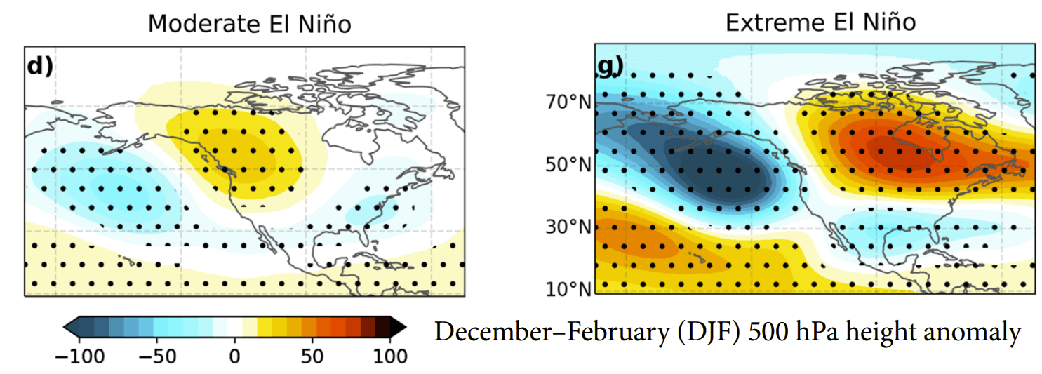
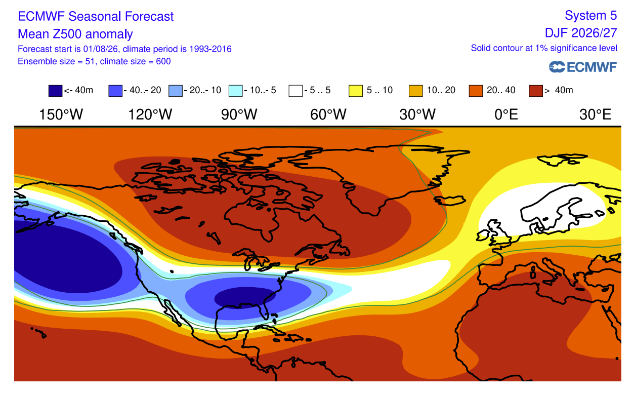
- North American Split-Flow: For North America, the resulting atmospheric bridge forces a deep, persistent low-pressure trough in the North Pacific, a massive blocking high-pressure ridge over Canada, and an active storm track across the southern and eastern United States.
- European Westerly Dominance: Across the Atlantic, the downstream teleconnection establishes a robust, mild westerly and southwesterly flow into mainland Europe, tempering cold-air outbreaks across the lowlands while steering moisture into the continent.
Chronology of Development: From Summer Heat to Mid-Winter Amplification
Understanding how Winter 2026/2027 will unfold requires examining the chronological progression of the El Niño life cycle and its atmospheric feedback loops from late summer through the heart of winter.
Late Summer and Fall: Ocean Priming
Throughout the summer and autumn months, westerly wind bursts over the equatorial Pacific continuously displaced warm upper-ocean waters eastward. This process fed the subterranean Kelvin wave, ensuring a continuous, self-sustaining supply of thermal energy. Seasonal runs from the ECMWF SEAS5 model since early winter have consistently trended upward, showing a historical strengthening bias that places the 2026 event among the strongest on record.
Early Winter (December): Pattern Establishment
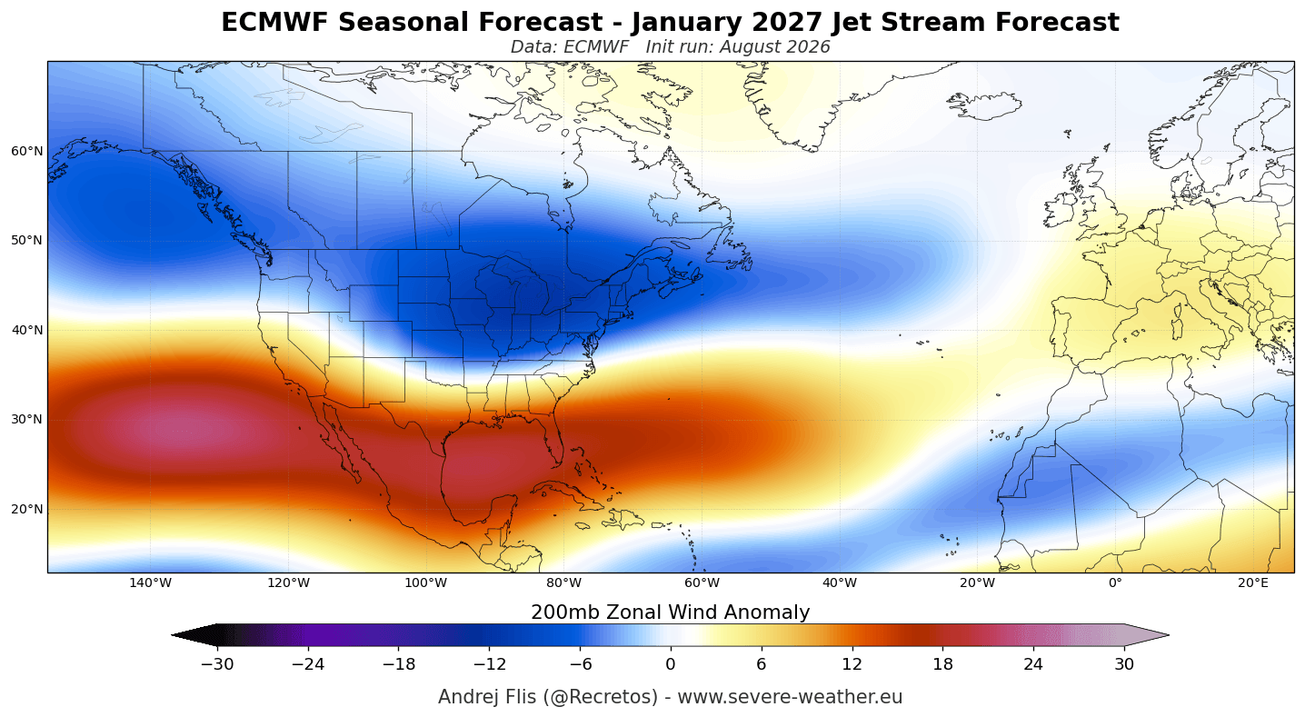
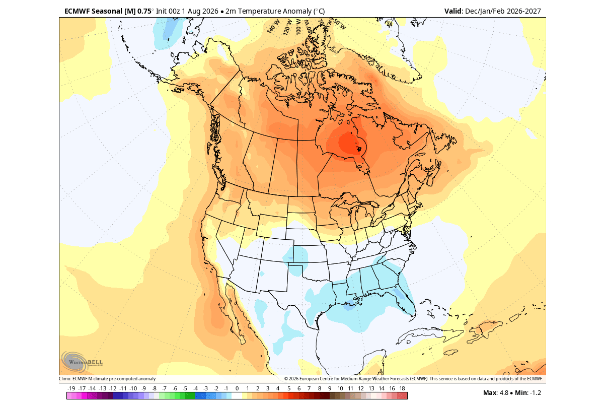
As meteorological winter begins, the tropical forcing establishes a planetary wave train. Pressure anomalies lock into place by December. A sprawling Aleutian Low deepens over the North Pacific, inducing strong upper-level ridging across Western and Central Canada. This configuration initiates the classic El Niño split-flow jet stream over North America, deflecting frigid Arctic air masses away from the northern tier while driving an active subtropical jet into the southern United States.
Mid-Winter (January): Stratospheric Feedback and Vortex Slowdown
By January 2027, the atmospheric response intensifies significantly. Seasonal models from both the ECMWF and the UKMO indicate an unusual deceleration of stratospheric zonal winds at the 10 hPa level, signaling an early mid-winter weakening of the stratospheric Polar Vortex.
While a robust Polar Vortex normally traps frigid polar air securely in the Arctic, this anticipated January slowdown reduces westerly confinement. Although a definitive Sudden Stratospheric Warming (SSW) event cannot be mapped months in advance, the background state strongly favors heightened atmospheric wave energy propagating upward from the troposphere, setting the stage for potential mid-to-late winter high-latitude blocking and sudden cold-air injections into the mid-latitudes.
Late Winter (February): Peak Amplification
Entering February 2027, multi-model ensembles from the North American Multi-Model Ensemble (NMME) and NOAA’s CFSv2 project maximum pattern amplification. The Canadian high-pressure ridge solidifies its grip on the north, while a deeply entrenched low-pressure anomaly dominates the southern and eastern United States. This structural alignment ensures that the winter’s most pronounced weather extremes—ranging from heavy southern precipitation to interior thaws—will peak during the final official month of the season.
Supporting Data: Multi-Model Consensus and Historical Analogs
To establish high confidence in these long-range projections, meteorologists rely on multi-model ensembles and historical composite analogs derived from past Super El Niño winters.
Model Convergence: ECMWF and NMME
The two premier global forecasting engines—the European ECMWF and the North American NMME—exhibit exceptional spatial agreement for Winter 2026/2027:
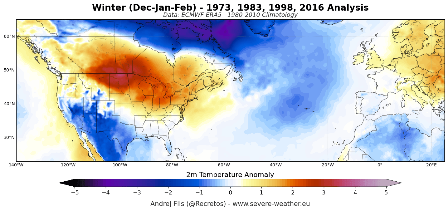
- Temperature Projections: Both models project widespread above-normal temperatures across Canada, the U.S. West Coast, and the Northeast, driven by persistent anticyclonic ridging. Conversely, below-normal temperatures are modeled across Texas, the Gulf Coast, and the Southeast, moderated by persistent cloud cover and storm activity. In Europe, a broad swath of above-average temperatures blankets the central and southern portions of the continent under the influence of Atlantic maritime air.
- Precipitation Projections: The precipitation anomalies mirror the pressure fields precisely. Enhanced moisture transport from an amplified Pacific jet yields above-normal precipitation across California, the Southwest, the Southern Plains, and the entire Gulf-to-Eastern U.S. seaboard. Europe similarly faces a wet signal across its western, central, and northern sectors due to frequent, moisture-laden Atlantic low-pressure systems.
Historical Super El Niño Composites (ERA5 Reanalysis)
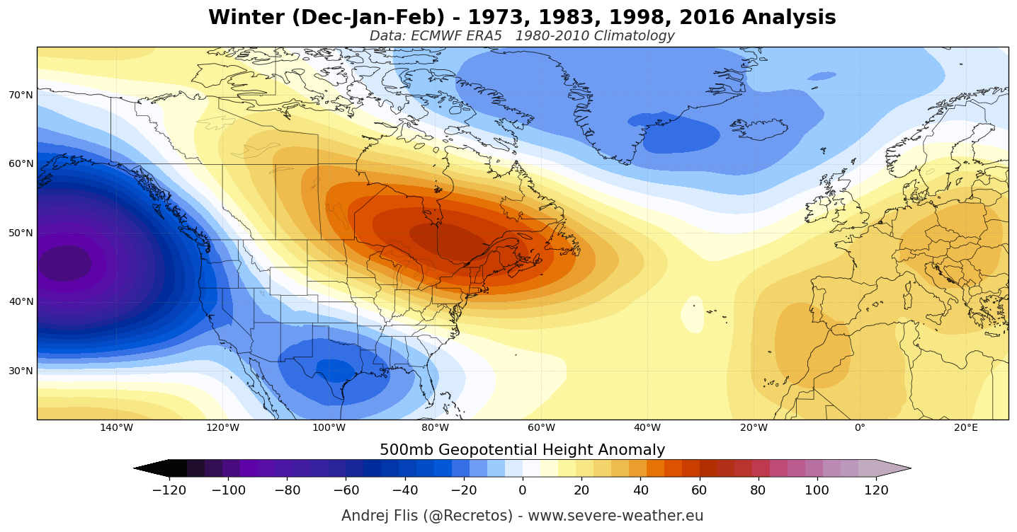
Comparing current forecasts against past extreme El Niño seasons (utilizing ERA5 historical reanalysis data) validates the structural integrity of the 2026/2027 outlook. Past events consistently produced:
- The Aleutian Low / Canadian Ridge Axis: A dependable high-pressure block over Canada that redirects continental polar air outbreaks.
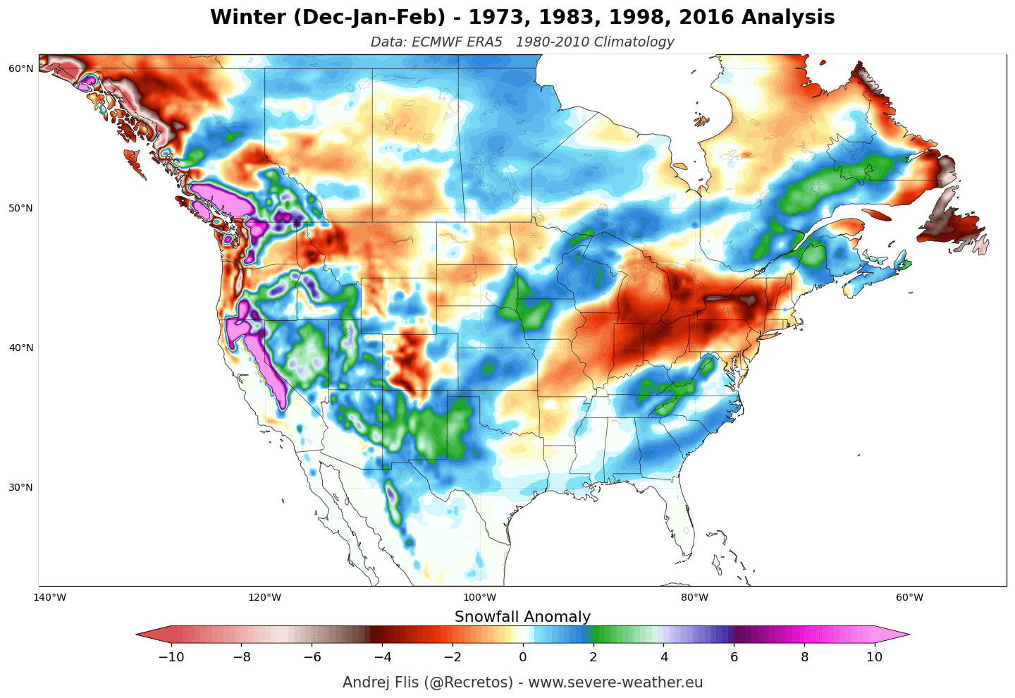
- Southern Snow Anomalies: Increased snowfall totals focused heavily over the Sierra Nevada, the Four Corners region, the Southern Rockies, and portions of the Central Plains, capitalising on the active southern storm track.
- Northern Snow Deficits: Widespread snowfall deficiencies across the Pacific Northwest, the Great Lakes, the Ohio Valley, and the Northeast, where mild Pacific air and suppressed northern tracks starve local ski resorts of natural snowpack.
Official Responses and Expert Analyses
Climatologists and long-range forecasters monitoring the 2026/2027 setup emphasize that the rarity of a Super El Niño elevates the predictability of macro-scale features while introducing complex regional variables.
According to seasonal tracking agencies, the unprecedented magnitude of the Pacific heat anomaly means that standard moderate-El Niño playbooks are insufficient. The sheer volume of latent heat being pumped into the upper troposphere forces jet stream configurations that override typical local noise.
However, forecasting authorities consistently issue a vital caveat regarding the European sector. While North American weather patterns bear a direct, statistically robust teleconnection to tropical Pacific sea surface temperatures, European winter weather remains chronically susceptible to competing teleconnections—most notably the North Atlantic Oscillation (NAO) and Arctic Oscillation (AO). Consequently, while the baseline model guidance for Europe leans toward a mild, wet westerly regime, sudden shifts in North Atlantic pressure gradients retain the capacity to introduce localized cold snaps that seasonal models cannot resolve at long lead times.
Implications for North America and Europe
The real-world impacts of the Winter 2026/2027 forecast carry significant socioeconomic, agricultural, and recreational consequences across the affected continents.
North America: The Great Snow and Temperature Divide
- Winter Sports and Ski Industry: A stark geographical polarization awaits winter enthusiasts. Resorts in California’s Sierra Nevada, Utah, and the Central-to-Southern Rockies (Colorado, Arizona, New Mexico) are exceptionally well-positioned for above-average snowpack and deep powder days driven by active southern storm cycles. Conversely, operators in the Pacific Northwest, the Cascades, British Columbia, the Northern Rockies, and northern New England face a challenging season defined by unseasonably warm temperatures and persistent snow deficits.
- Energy and Infrastructure: The southern and eastern United States must prepare for an active, wet winter featuring frequent low-pressure systems. This increases the risk of heavy rainfall events, localized flooding, and disruptive ice or mixed-precipitation threats along transition zones. Meanwhile, heating demands across the northern tier and Canada are projected to run below historical averages under the dominant high-pressure ridge.
Europe: Elevation Dictates the Snow Line
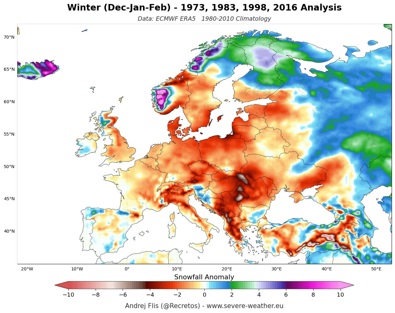
- The Alpine Divide: For Europe, the dominant Atlantic westerly flow ensures that lowlands and mid-elevation ranges will experience widespread temperature and snowfall deficits. Mountain ranges heavily reliant on lower altitudes—such as the Pyrenees, Apennines, Balkans, and Scottish Highlands—face a difficult operational setup.
- High-Altitude Reliability: The saving grace for European skiing lies in altitude. Because Atlantic systems transport abundant moisture, the highest elevations of the western and central Alps (specifically peaks residing above 1,800 to 2,000 meters) will capture significant snowfall whenever temperatures remain sufficiently depressed. Northern European destinations will likewise retain more reliable, colder winter regimes.
Conclusion
As Winter 2026/2027 approaches, the convergence of an extreme Super El Niño, an amplified split-flow jet stream, and an anticipated mid-winter disruption of the stratospheric Polar Vortex sets the stage for one of the most dynamically fascinating cold seasons in recent memory.
While millions across the southern and western United States brace for an active, stormy, and occasionally snowy winter—and western mountain ranges prepare for bountiful powder—northern regions and much of European civilization must navigate a milder, stormier Atlantic regime. As always, long-range forecasters will continue tracking high-frequency atmospheric shifts, but the overarching macro-scale architecture for the winter season is firmly locked into place.
