

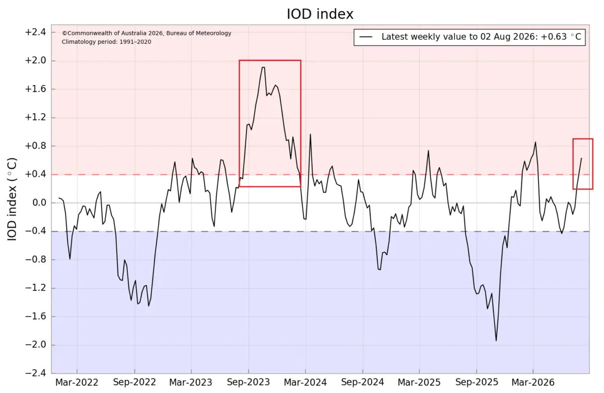
As the Northern Hemisphere transitions through late summer and looks toward the colder months, meteorologists and climate modelers are tracking a rare, highly energetic pairing of global ocean anomalies. A rapidly strengthening Super El Niño across the tropical Pacific is now being mirrored by a developing positive Indian Ocean Dipole (IOD).

Seasonal forecasts indicate that this dual-ocean atmospheric system will persist through the autumn and into early winter. By synchronizing tropical wave forcing across two separate ocean basins, these concurrent anomalies are poised to act as a planetary weather engine, driving significant shifts in the jet stream and altering temperature, precipitation, and snowfall trends across the United States, Canada, and Europe for the Winter 2026/2027 season.
Main Facts: The Anatomy of a Dual-Ocean Forcing Event
At the core of the upcoming winter’s projected climate patterns is an unprecedented alignment of tropical energy drivers.
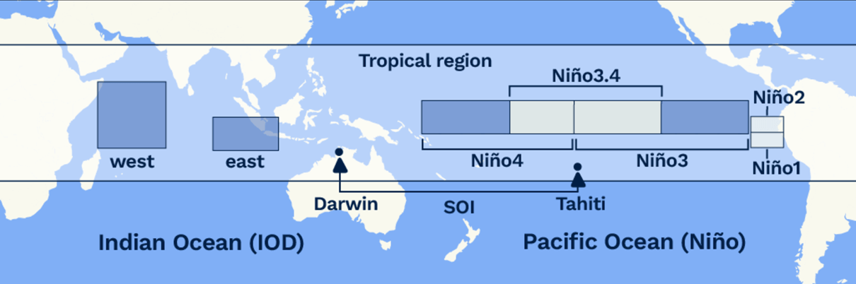
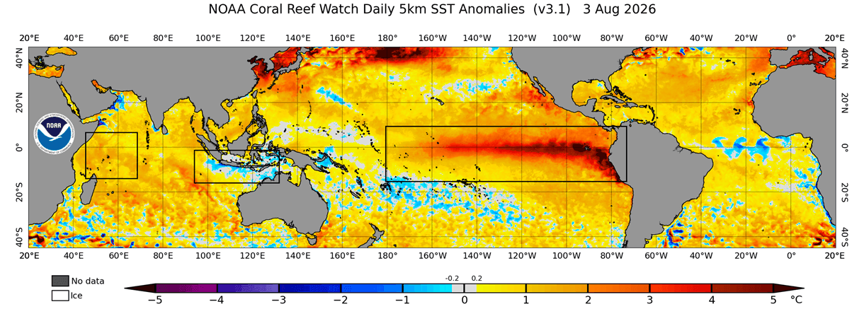
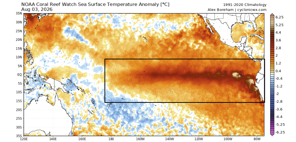
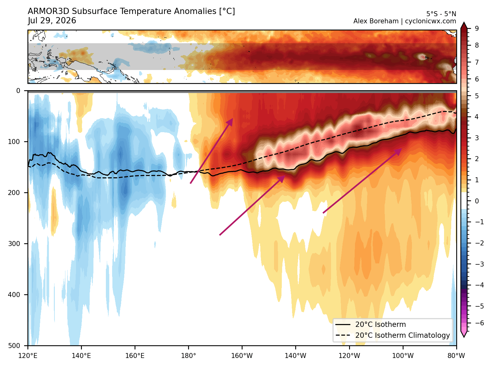
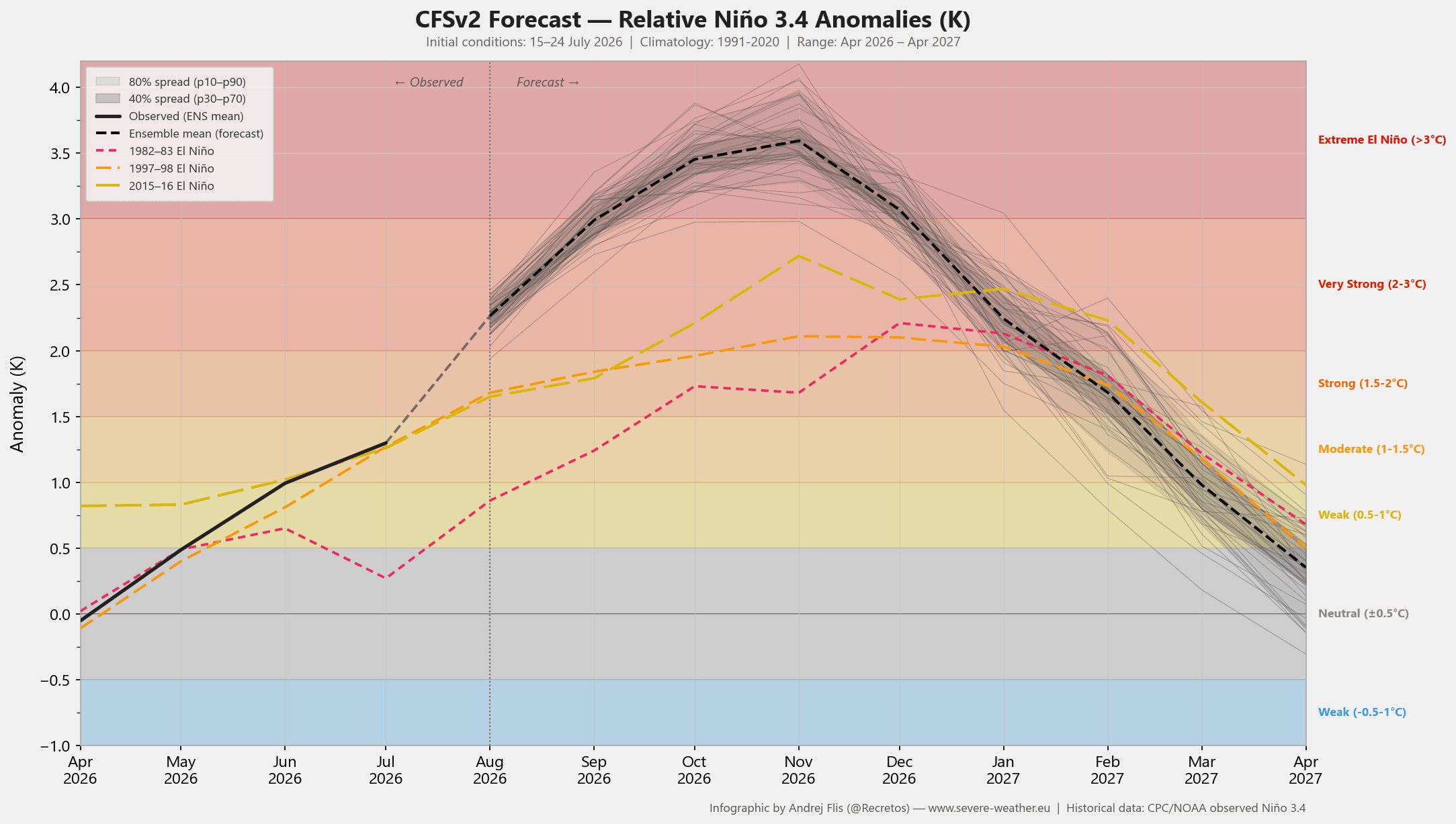
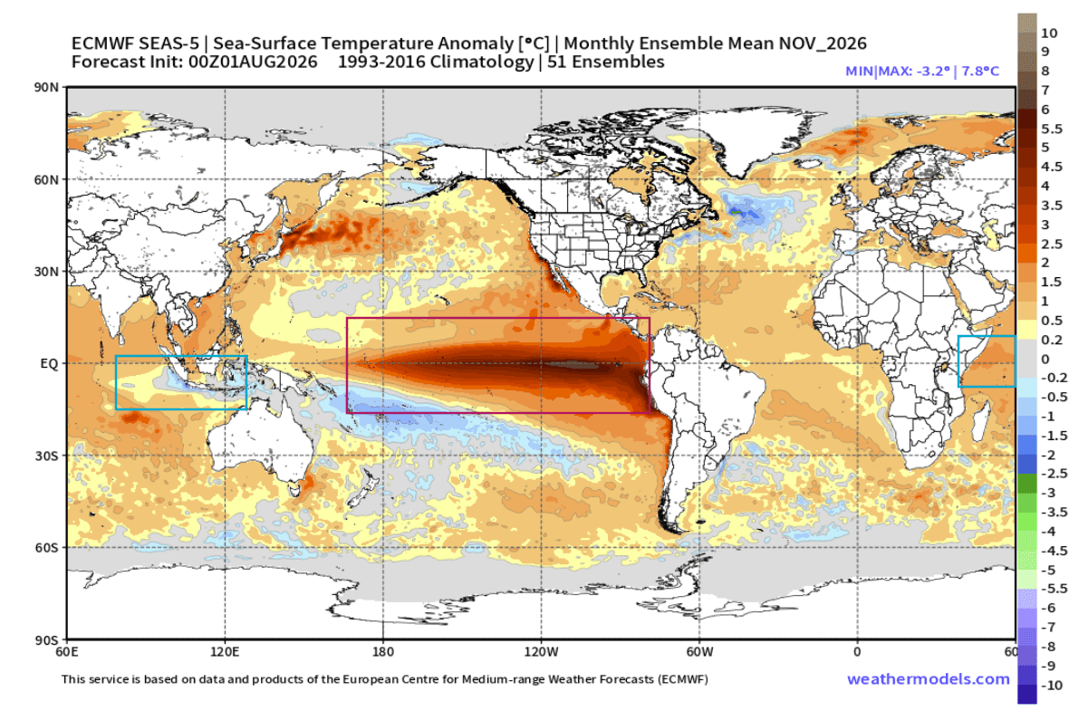
- The Super El Niño: Sea surface temperature anomalies in the central and eastern Pacific ENSO regions are accelerating at a historic pace. Early August analyses reveal positive temperature anomalies reaching +4°C to +5°C on the surface, while subsurface data indicates massive Kelvin waves pushing temperatures up to +8°C above normal in the upper 500 meters of the ocean.
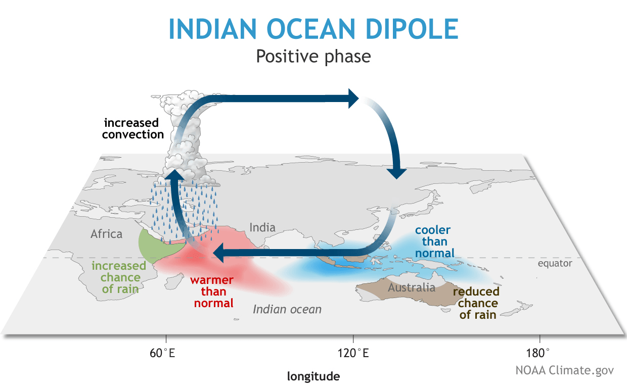
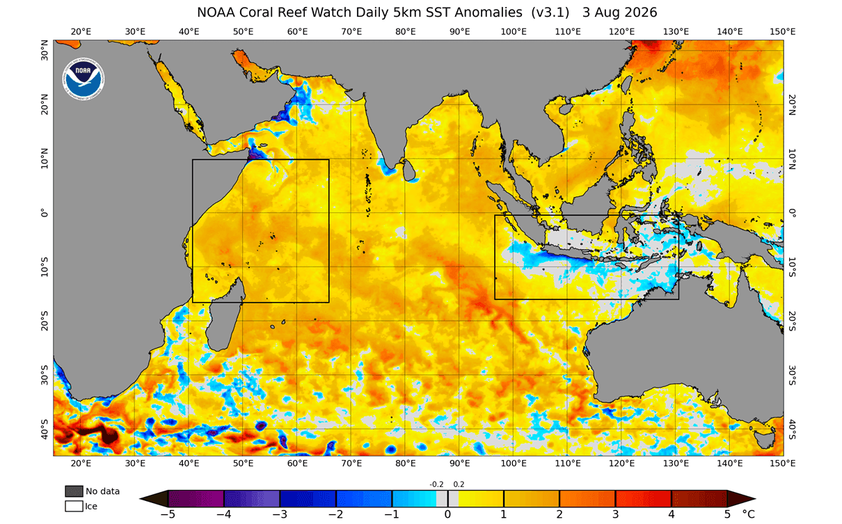
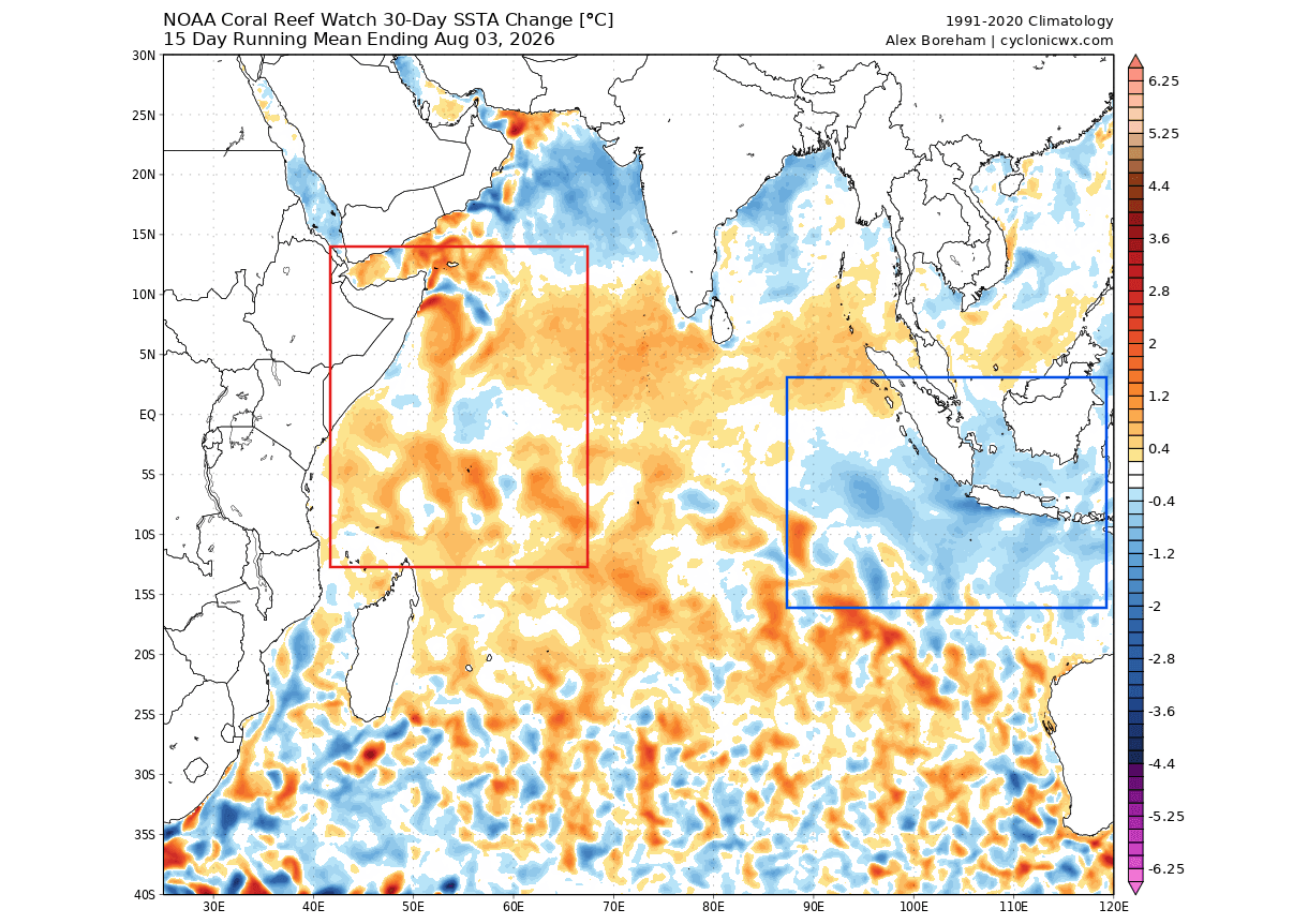
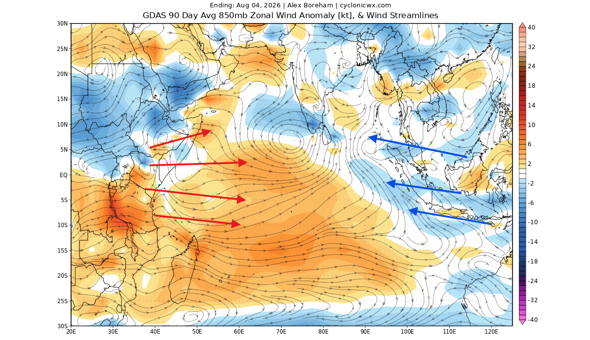
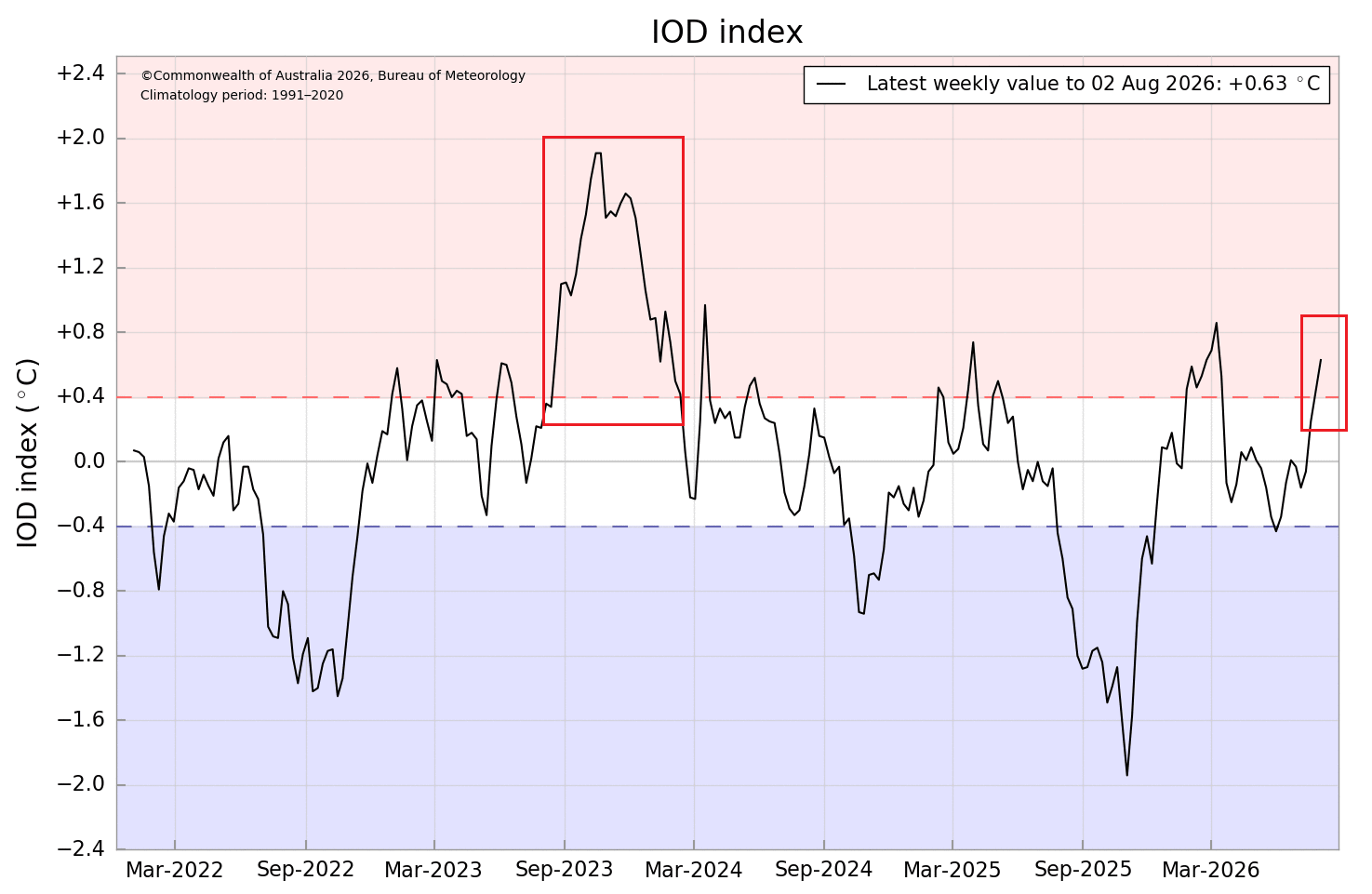
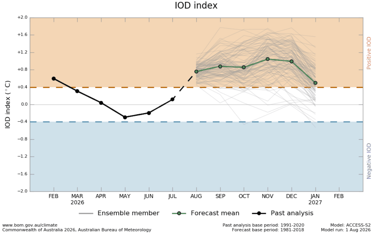
- The Positive Indian Ocean Dipole (IOD): Simultaneously, the Indian Ocean is entering a textbook positive IOD phase. This climate driver creates opposing temperature anomalies—cooling in the eastern basin and warming in the west—driven by altered trade wind patterns and convective activity.
- Synchronized Atmospheric Engine: Rather than acting in isolation, the Super El Niño and the positive IOD form a coupled global system. Together, they anchor persistent areas of rising and sinking air across the tropics, launching powerful atmospheric wave trains that reshape global pressure fields and steer mid-latitude jet streams.
Chronology: From August Development to Winter Impact
The evolution of the Winter 2026/2027 climate pattern follows a distinct chronological buildup, beginning in the tropical ocean basins and cascading into continental weather regimes.
Late Summer: Subsurface Surges and Atmospheric Locking
The foundation for the upcoming winter is laid during the summer months. In the tropical Pacific, subsurface warmth generated by deep Kelvin waves continues to rise to the surface, fueling the rapid growth of the Super El Niño. Concurrently, weakening trade winds across the western Indian Ocean and strengthening easterlies in the east trigger the positive IOD phase.
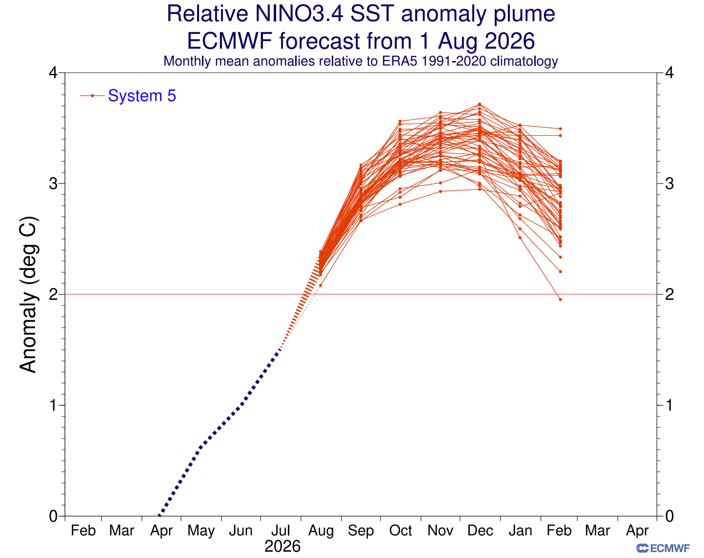
By August, computer models from the European Centre for Medium-Range Weather Forecasts (ECMWF) and NOAA’s NCEP show these anomalies locking into the global atmosphere, establishing the velocity potential patterns—zones of robust rising and sinking air—that will dictate seasonal circulation.
Autumn: Amplification of Tropical Forcing
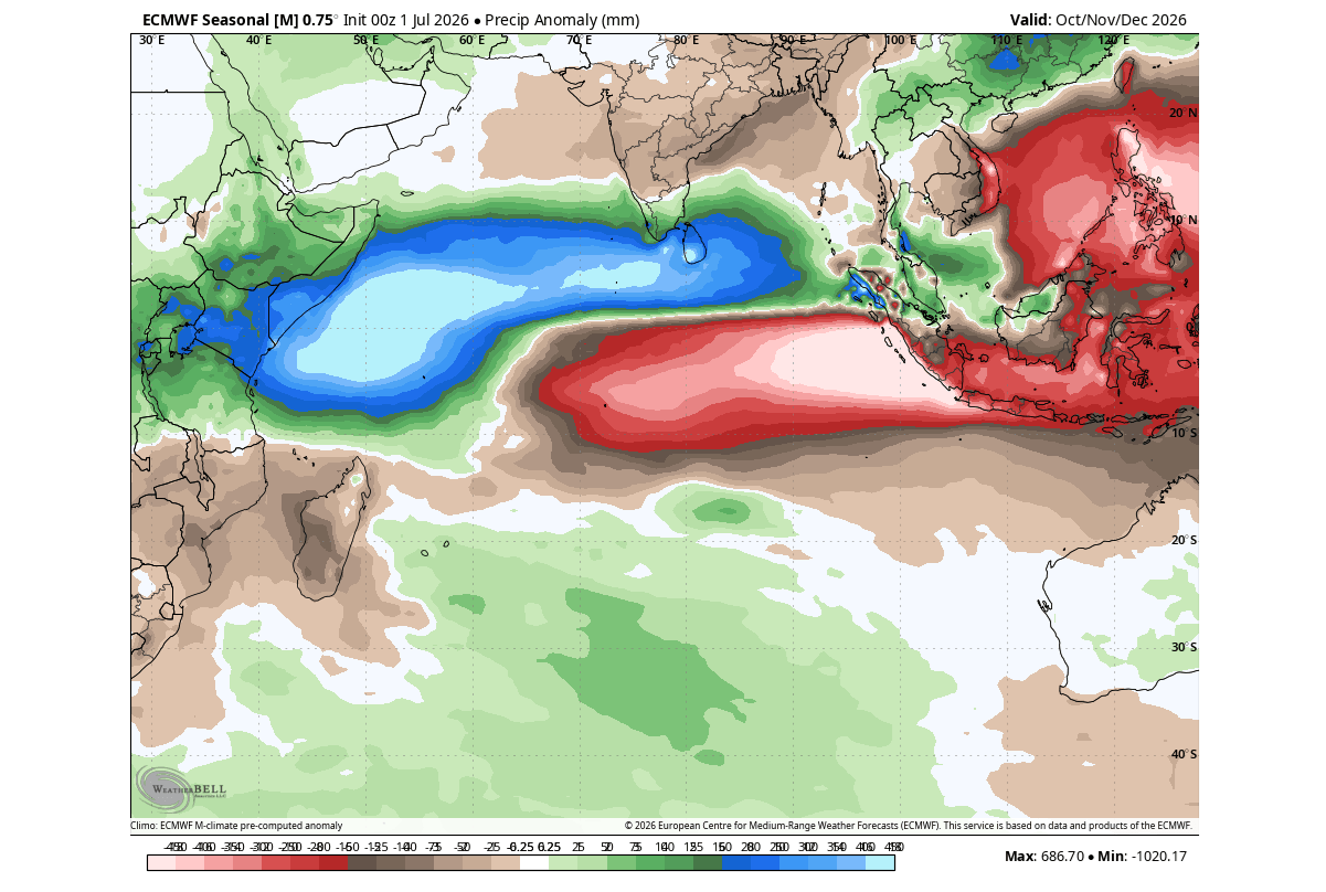
As the calendar turns to fall, the atmospheric footprint of the dual-ocean system solidifies. ECMWF ensemble forecasts for the autumn season show severely altered rainfall patterns over the Indian Ocean basin, marked by a massive precipitation deficit in the cooler eastern waters and high rainfall totals in the warmer west. This tropical forcing generates a planetary-scale Rossby wave train, setting up the pressure ridges and troughs that will govern Northern Hemisphere weather by December.
Winter 2026/2027: Peak Manifestation
By mid-winter, the atmospheric wave train reaches its maximum amplitude. High-pressure blocking stabilizes over Canada and the North Pacific, while a deep, highly active low-pressure trough digs across the southern and eastern United States. This configuration creates a stark continental split-flow, dictating storm tracks and freeze-thaw cycles through January and February 2027.
Supporting Data: What the Models and Historical Records Show
Long-range forecasting for Winter 2026/2027 relies on a convergence of multi-model consensus data—including outputs from the ECMWF, BOM, and NCEP CFSv2—alongside historical regression analyses spanning the past 65 years.
The Pacific Engine and Kelvin Waves
Current oceanic analyses show that the developing Super El Niño is tracking well above standard thresholds. Forecast models from both ECMWF and NCEP project peak surface anomalies exceeding the extreme +3°C to +6°C mark during the height of the event. This positions the 2026/2027 El Niño among the strongest ever recorded. Below the surface, the sheer volume of warm water tied up in the eastward-propagating Kelvin wave guarantees that this thermal energy will dominate tropical-extratropical interactions for months.
Pressure Anomalies and Split-Flow Regimes
Historical climate data matching a positive IOD paired with an El Niño reveals a recurring northern hemisphere pressure signature.
- North America: A robust high-pressure ridge establishes itself over western Canada and Alaska, diverting polar air away from the far north while forcing a southern branch of the jet stream directly across the United States.
- Europe: The upper-level wave train crosses the North Atlantic to induce a high-pressure anomaly over southern and Mediterranean Europe, contrasted by low-pressure anomalies across northern and northwestern Europe.
Implications for North America and Europe
The translation of tropical ocean energy into mid-latitude weather will produce highly divergent regional outcomes across the Northern Hemisphere.
United States and Canada: The Split-Flow Winter
For North America, the projected setup implies a classic El Niño winter characterized by regional disparities in temperature and snowfall:
- Temperatures: Mild, above-normal temperatures are favored across western Canada, the northern tier of the United States, and the Northeast. Conversely, the southern half of the U.S.—stretching from Texas across the Gulf Coast and into the Southeast—is expected to experience cooler-than-average conditions, reinforced by persistent cloud cover and storm activity.
- Precipitation and Snowfall: An active southern storm track will pump abundant Pacific moisture into the Southwest, the Southern Plains, and up the East Coast. Where this moisture trajectory intersects periodic southward plunges of cold air, the potential for heavy winter storms, ice events, and significant snowfall increases markedly across the Central Plains, Midwest, Mid-Atlantic, and interior Northeast. Meanwhile, the Pacific Northwest, northern Great Lakes, and southern Canada are projected to face below-average seasonal snowfall totals due to prevailing warmth and northern blocking ridges.
Europe: Westerly Dominance and Milder Trends
While Europe sits further downstream from the primary tropical forcing zones, the teleconnection still exerts significant control over the continent’s seasonal weather.
- Circulation and Temperature: ECMWF winter forecasts indicate a strong north-south pressure gradient, boosting a persistent westerly flow from the Atlantic. This regime favors mostly above-normal temperatures across central and southern Europe. However, periodic shifts in low-pressure tracks could introduce temporary northerly flows to the United Kingdom and Ireland.
- Precipitation and Snow: Enhanced westerly moisture transport will bring above-normal precipitation totals to large parts of the continent. Broad, continuous lowland snowfall is generally not favored under this mild pattern; instead, significant snow accumulation will likely be restricted to higher elevations and the extreme north and northeast of the continent.
Outlook and Next Steps
As the atmospheric and oceanic systems continue their march toward peak intensity, meteorologists will monitor high-frequency shifts in trade wind strength, subsurface Kelvin wave dissipation, and polar vortex stability.
These evolving dynamics will be factored into subsequent updates as autumn progresses. Residents across North America and Europe are advised to follow updated regional forecasts as the signals from this historic dual-ocean event become even more sharply defined ahead of the 2026/2027 winter season.
