

BRUSSELS / GENEVA — Meteorological agencies and severe weather forecasters across Europe are on high alert following the issuance of a high-tier severe weather outlook for late August 2026. A powerful and expansive two-day convective outbreak is projected to strike large swathes of the continent, bringing an explosive mix of extreme hazards—including giant hail, destructive straight-line winds, flash floods, and potential tornadoes.
The severe weather threat window spans from Thursday, August 27, at 06:00 UTC through Saturday, August 29, at 06:00 UTC. The event is expected to impact millions of residents across France, Switzerland, Germany, Austria, the Czech Republic, and Poland.
Forecaster Marko Korošec of Severe Weather Europe has highlighted the dynamic drivers behind the incoming system, pointing to an unstable cocktail of extreme atmospheric moisture, intense low-level wind shear, and high-amplitude jet stream dynamics.
1. Main Facts and Synoptic Overview
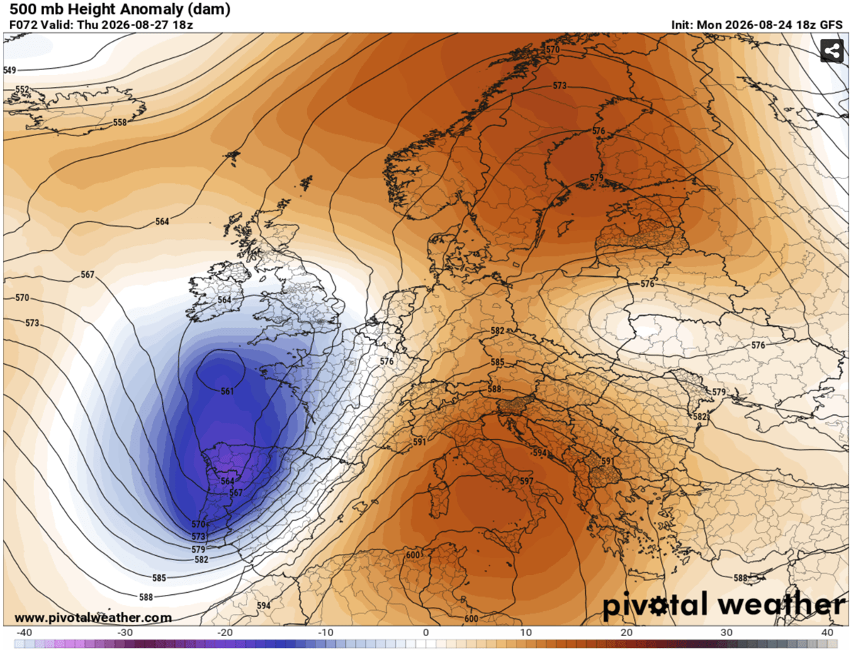
The primary catalyst for this impending severe weather episode is a large, deep upper-level trough pushing aggressively into Western Europe. This weather feature is interacting with a strong, persistent blocking high-pressure system anchored over the Mediterranean region.
The stark pressure and temperature gradients established between these two macro-scale meteorological features have spawned a powerful southwesterly jet stream. Originating over eastern Spain, the jet tears across the western Mediterranean and streams directly into southern and eastern France.
Beneath this dynamic jet stream lies an exceptionally humid and heat-laden air mass, heavily fueled by an ongoing, intense Mediterranean heatwave. As this unstable maritime air surges northward, it encounters the advancing cold front associated with the upper-level trough. This dynamic setup creates a textbook recipe for severe, organized convective activity on a continental scale.
Core Hazards Forecasted:
- Large to Giant Hail: Stones measuring 6 cm to 10 cm (or potentially larger) capable of severe structural and vehicular damage.
- Destructive Winds: Straight-line convective wind gusts frequently exceeding 100 km/h, with localized peaks potentially surpassing 120 km/h.
- Tornado Risk: Enhanced low-level shear and storm-relative helicity, particularly in targeted river valleys, signaling a distinct threat of tornadic activity.
- Flash Flooding: Excessive, torrential rainfall rates threatening localized urban and rural inundation.
2. Chronology of the Outbreak
The severe weather event is structured as a progressive, two-day wave moving from west to east across the European continent.
Phase One: Thursday, August 27 — France, Switzerland, and Germany
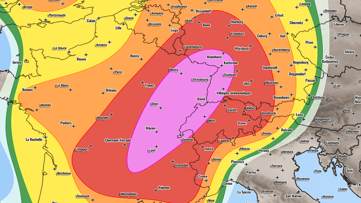
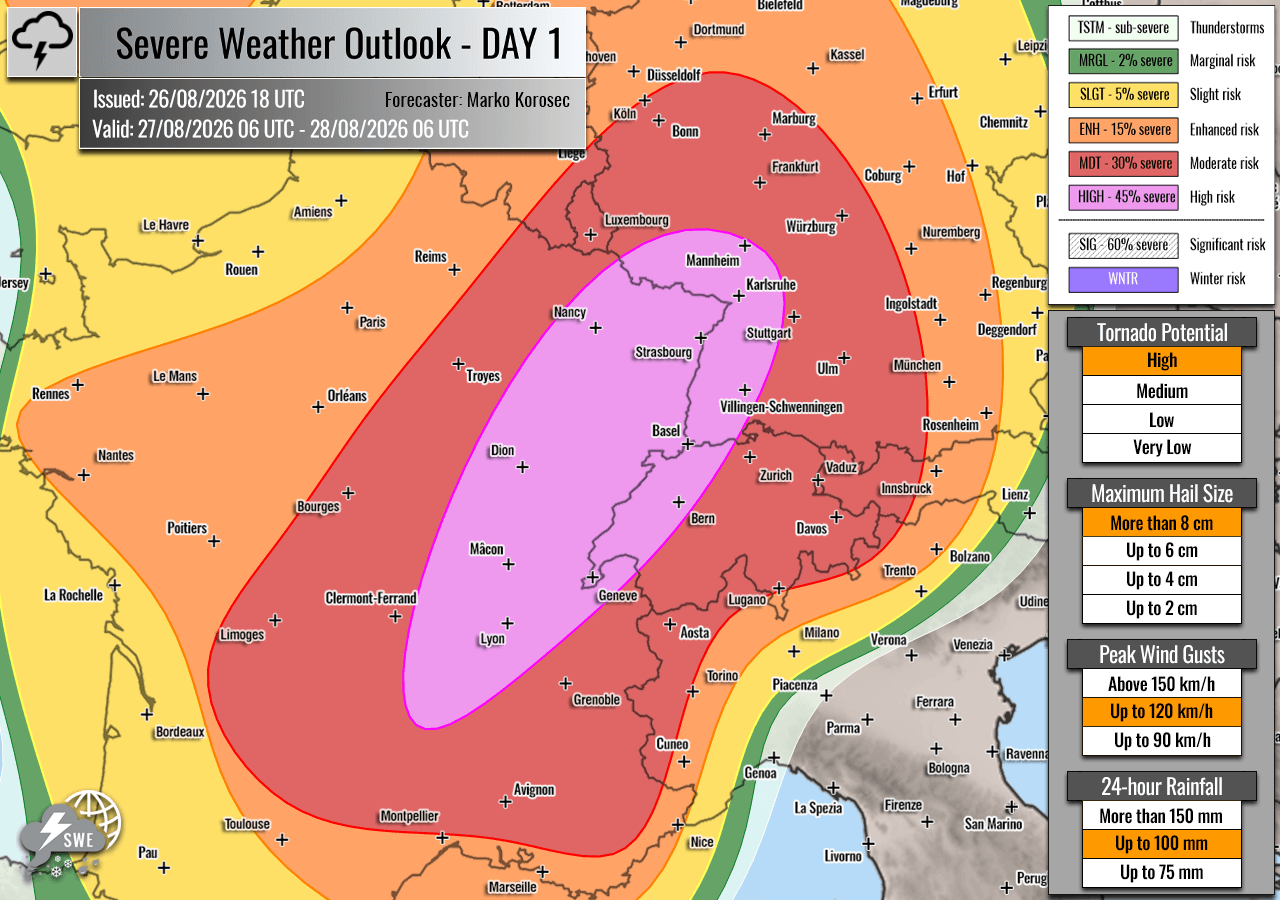
The severe weather kicks off violently during the midday hours on Thursday. The highest-tier HIGH risk has been designated for east-central France, western Switzerland, and southwestern Germany.
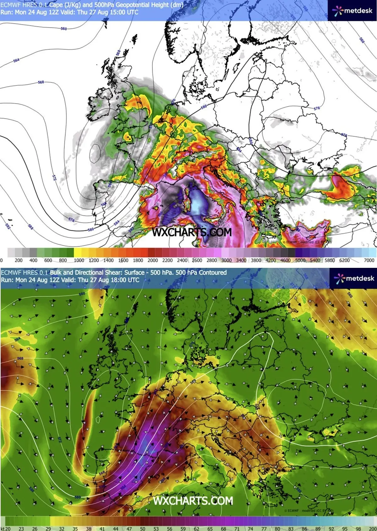
As daytime heating peaks, explosive thunderstorm development is expected to ignite over the Massif Central before racing rapidly northeastward into the Rhône Valley. In these areas, MLCAPE (Mixed-Layer Convective Available Potential Energy) values are modeled to surge between 2,000 and 4,000+ J/kg, representing an environment of extreme instability.
- The Afternoon Threat: Isolated, intense supercells will dominate the early stages. The favorable low-level wind profile in the Rhône Valley significantly elevates the risk of tornadic supercells. At the same time, these storms will produce very large to giant hail and torrential downpours.
- The Evening Progression: By Thursday evening, individual supercells are expected to merge into larger convective clusters and line segments. As they track swiftly northeast into southwestern and central Germany, the primary hazards will transition to widespread damaging winds, wind-driven hail, and continuous heavy rainfall.
- Secondary Zones: Surrounding regions—including the remainder of France, Switzerland, northwest Italy, western Austria, the Benelux union, and southern England—face moderate to enhanced (MDT/ENH) risks. While storm coverage here will be comparatively isolated, localized severe winds and heavy rain remain a distinct possibility.
Phase Two: Friday, August 28 — The Alps, Central Europe, and Poland
As the primary trough axis shifts eastward, the focal point of the severe weather migrates across the Alpine spine and into Central Europe. A significant MDT (Moderate) risk has been issued for eastern Switzerland, Austria, the broader Alpine region, the Czech Republic, and southwestern Poland.
- Early Afternoon Initiation: Isolated thunderstorms will begin firing over the high terrain of the Alps early Friday afternoon, fueled by lingering instability and strong ambient wind shear. These will rapidly organize into powerful multicells and supercells.
- Late-Day Mesoscale Convective Systems (MCS): A critical concern for Friday evening is the potential consolidation of these storms into a massive, organized Mesoscale Convective System (MCS). High-resolution numerical models (including regional WRF runs) indicate that bowing segments within this line could produce violent, destructive straight-line winds exceeding 120 km/h.
- Nighttime Trajectory: This severe convective system is forecast to race northeastward overnight, sweeping out of southeastern Germany and northeastern Austria into the southwestern Czech Republic and onward into southwestern Poland, maintaining its destructive potential well into the dark hours.
3. Supporting Meteorological Data and Modeling
Meteorological insights compiled from major forecasting platforms—including Meteoadriatic, Wxcharts, and PivotalWeather—illustrate a high degree of model consensus regarding the severity of this event.
The atmospheric parameters driving the outlook are exceptionally pronounced:
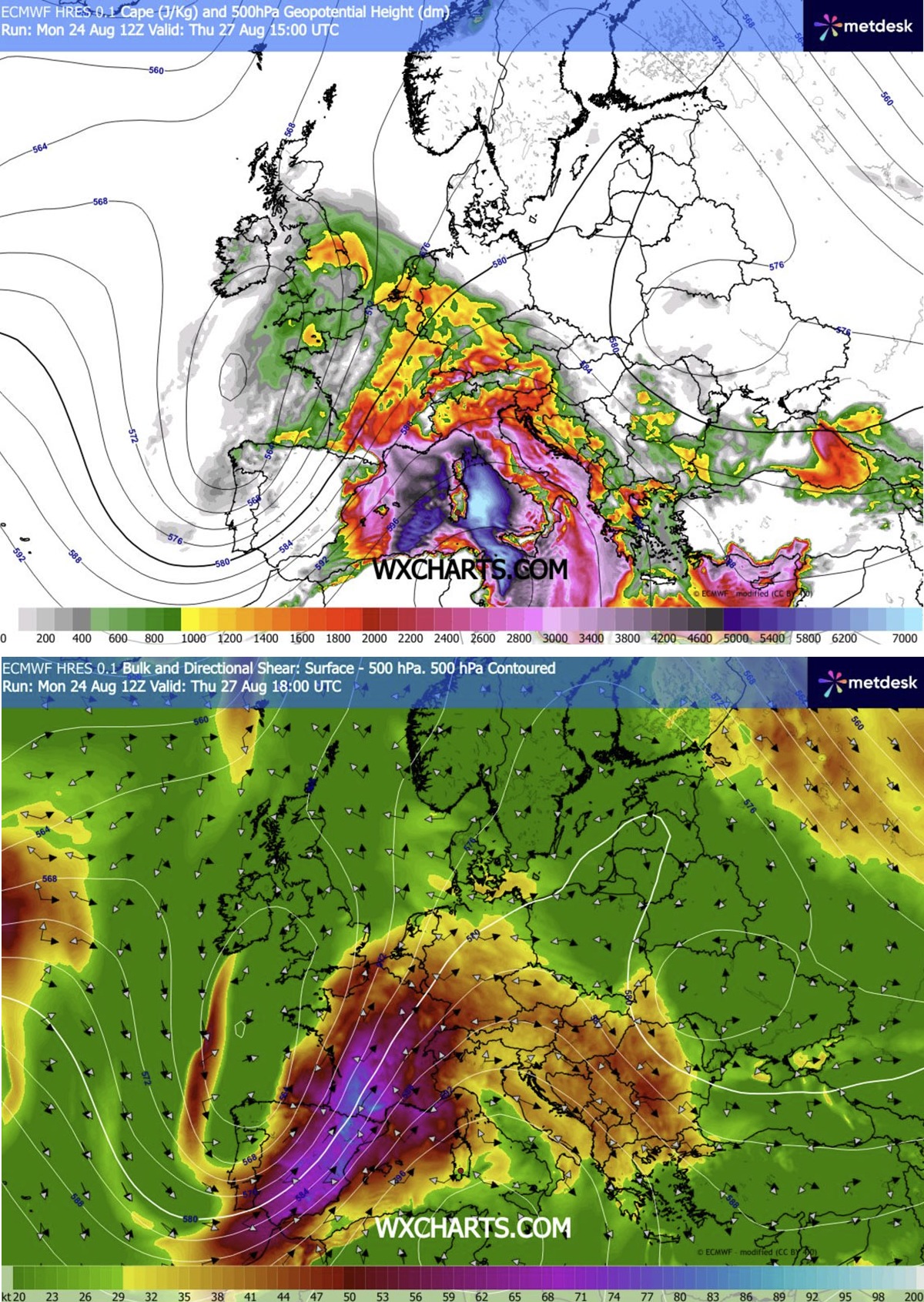
- Instability (CAPE): Surface dewpoints lifted northward by robust southerly boundary-layer flow will yield thermodynamic energy profiles capable of sustaining violent updrafts. MLCAPE values exceeding 3,000 J/kg over southeastern France provide the explosive fuel needed for giant hail production.
- Wind Shear: Deep-layer shear values (0–6 km bulk shear) in excess of 20 to 30 meters per second will ensure that storms quickly become vertically tilted and structurally organized, allowing them to sustain intensity for hours.
- Storm-Relative Helicity (SRH): Low-level hodographs display notable curvature in the lowest 1–3 kilometers across the Rhône Valley and parts of Germany, a classic signature for rotation within supercell updrafts and a heightened tornado threat.
4. Official Responses and Preparedness
Civil protection agencies, municipal authorities, and emergency response services across the affected nations have begun issuing pre-emptive safety advisories.
- France: Meteo-France and regional prefectures are urging residents in the high-risk zones of east-central France to secure outdoor property, vehicles, and temporary structures. Local authorities are preparing emergency drainage teams to counter potential flash flooding in urban environments.
- Germany and Switzerland: Weather services have warned transport authorities, railway operators, and aviation hubs of potential severe disruptions. High winds and localized flash floods threaten major transit corridors during Thursday evening and Friday commuting hours.
- Central Europe (Austria, Czech Republic, Poland): Emergency management networks in the Czech Republic and southwestern Poland are placing regional rescue services on standby ahead of the anticipated Friday night MCS arrival, specifically warning the public about the danger of falling trees and structural damage from potential hurricane-force wind gusts.
5. Socioeconomic and Infrastructural Implications
An outbreak of this magnitude over densely populated and heavily traveled regions of Western and Central Europe carries severe socioeconomic implications.
- Agriculture: Vineyards and orchards across France, Switzerland, and northern Italy are acutely vulnerable to giant hail. A severe multi-centimeter hail swath passing through these agricultural regions could devastate seasonal crops minutes before harvest.
- Transportation and Energy Infrastructure: Widespread straight-line winds pose a direct threat to overhead power lines, leading to potential multi-region blackouts. Major European transit arteries—including vital cross-border autobahns, railway lines, and regional airports—face significant delays and temporary closures as the storms cross their paths.
- Property and Urban Areas: Flash flooding in metropolitan centers with high impervious surface ratios could overwhelm municipal drainage systems, leading to rapid water accumulation in subterranean infrastructure, underpasses, and residential basements.
Residents and travelers within the designated HIGH and MDT risk zones are strongly advised to monitor real-time weather alerts, heed local civil defense instructions, and ensure they have secure shelter identified ahead of the storm arrivals.
