

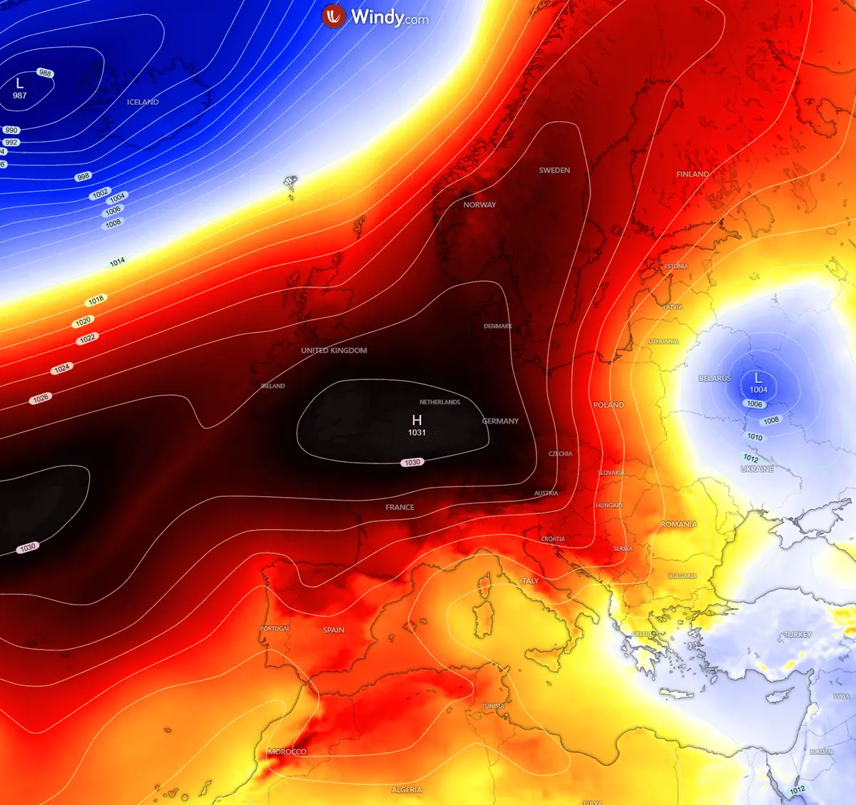
BERLIN/ATHENS — A dramatic and abrupt shift in the European weather pattern is well underway, bringing an abrupt halt to lingering late-summer warmth across the eastern half of the continent. A powerful, high-amplitude upper-level blocking ridge building aggressively over the North Atlantic and Scandinavia has engineered a direct atmospheric corridor. This synoptic setup is driving a severe, meridional flow straight from the high latitudes of the Arctic, spilling dense, polar-origin air deep across Eastern Europe, the Balkan Peninsula, and into northwestern Turkey.
Meteorological models indicate that daytime high temperatures across the impacted zones will plunge precipitously by 10°C to 15°C compared to recent seasonal averages. As the polar air mass cements its foothold, a sweeping thermal flip is taking place, transforming warm late-September conditions into a landscape of crisp, clear skies, brisk winds, and the season’s very first agricultural frosts.

Main Facts
The ongoing weather anomaly represents one of the most significant early-season cold air intrusions for late September in recent years, creating a stark meteorological split across the European continent.
- The Driver: A massive upper-level blocking ridge over the North Atlantic and Scandinavia has teamed up with a developing surface high-pressure system, creating a powerful Scandinavian High. This configuration forces a strict north-to-south (meridional) atmospheric corridor.
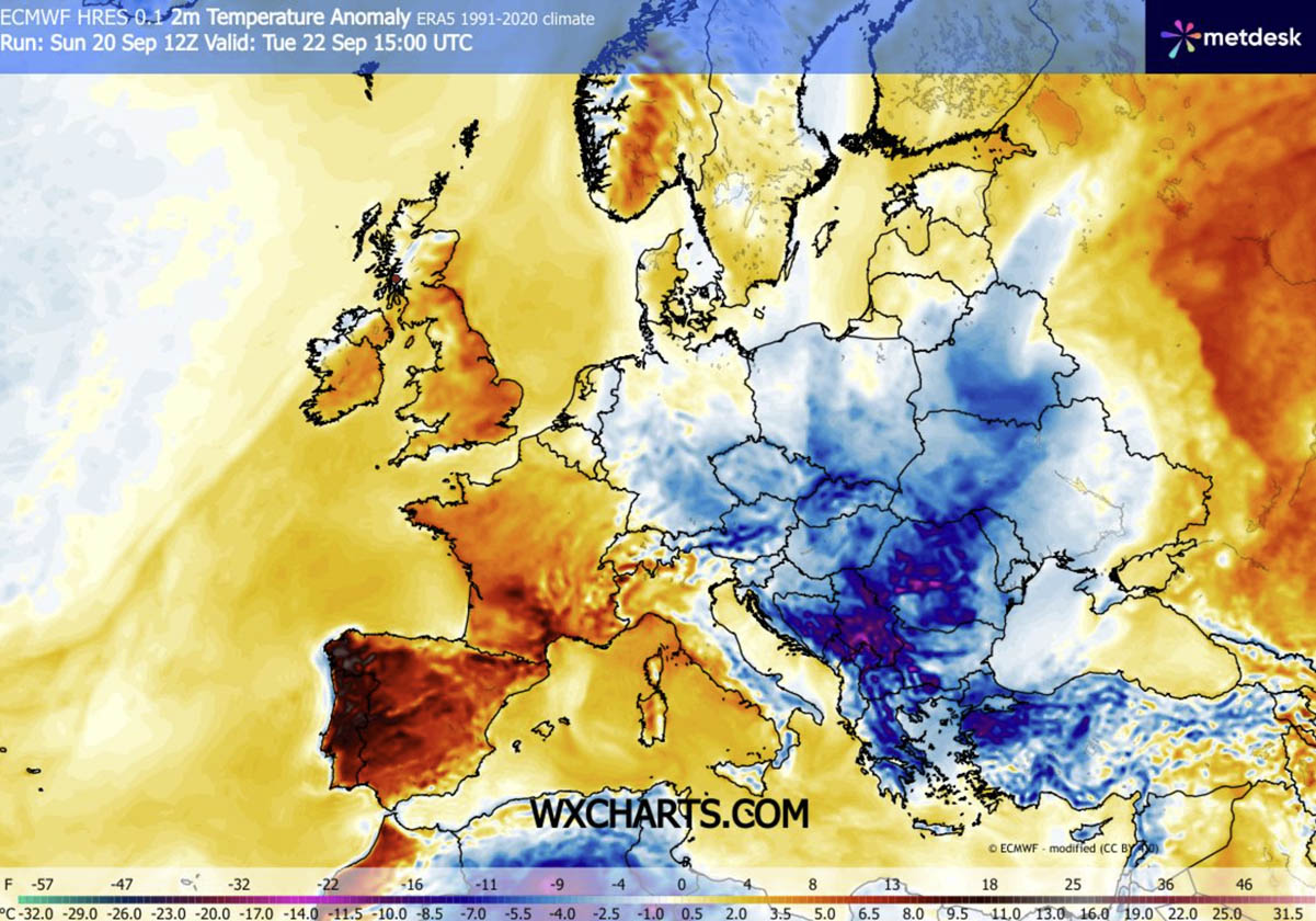
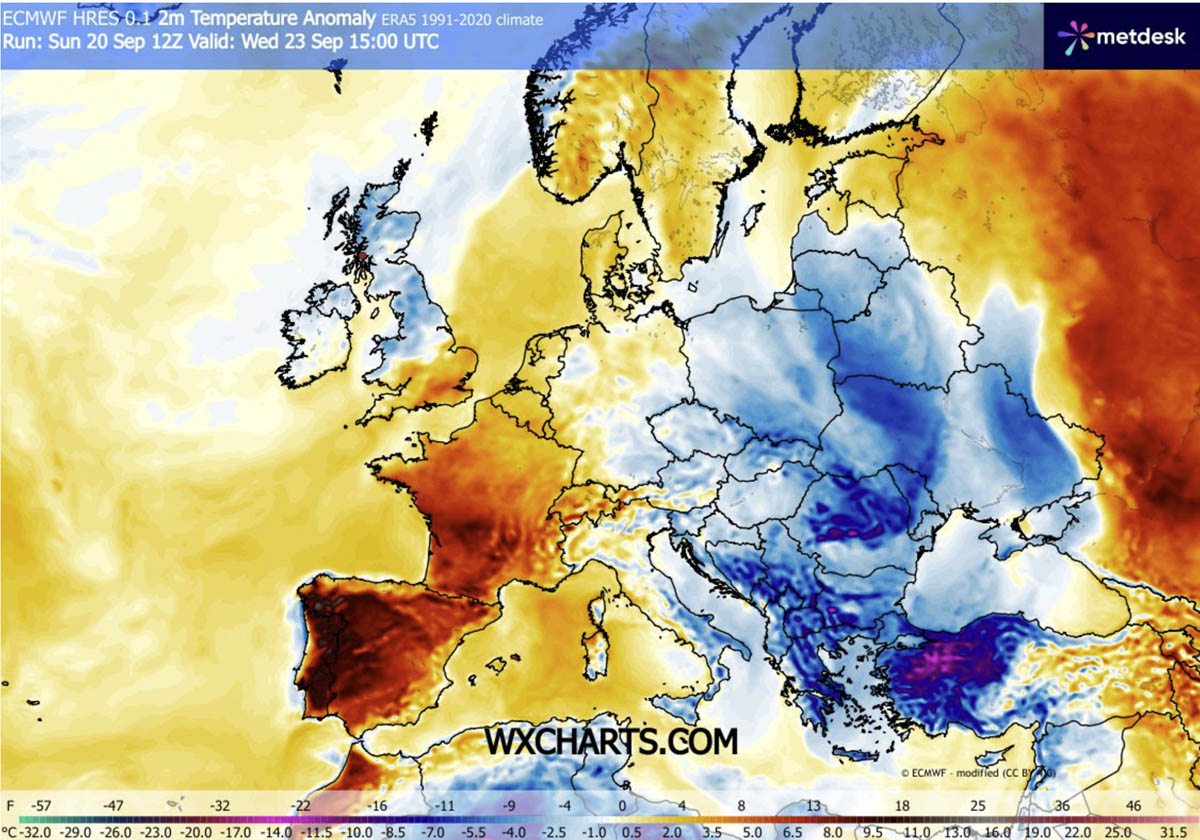
- The Thermal Drop: Daytime high temperatures are falling 10°C to 15°C below typical seasonal norms. At the 850 hPa level, mid-troposphere temperatures are registering 6°C to 10°C below normal, culminating in ground-level temperature anomalies reaching 12°C to 16°C below average in parts of the southern Balkans and western Turkey.
- Geographical Impact: The Arctic blast is sweeping aggressively down from the Baltic states through central and eastern Europe, encompassing the Carpathian region, Romania, Bulgaria, Serbia, Bosnia, Greece, the Aegean Sea, and northwestern Turkey.
- Hazards and Impacts: Low-lying valleys and agricultural basins face the threat of their first nocturnal frosts of autumn 2026. Higher elevations, particularly across the Carpathians and the Northern Balkans, are bracing for their first notable high-altitude snowfalls as freezing levels drop dramatically.
- Duration: While severe, the cold snap is expected to be relatively transient. The dipole pattern will peak mid-week before Western European ridging begins to reassert itself and expand eastward toward the final days of September.
Chronology of the Arctic Intrusion
The rapid evolution of this weather event has played out across a precise meteorological timeline, displacing warm continental air in a matter of days.
Sunday to Monday: Pattern Establishment and North Atlantic Forcing
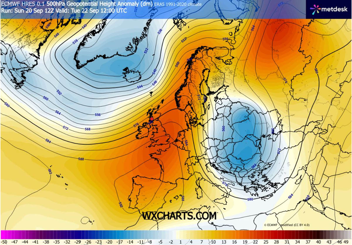
The synoptic foundation was laid as a strong upper-level ridge over Western and Southwestern Europe expanded northward, morphing into a resilient Scandinavian High. Simultaneously, a large upper-level trough began carving its way eastward, digging into Eastern Europe. This pressure configuration established the classic north-south pressure gradient necessary to tap into Arctic reservoirs. Surface high-pressure zones began expanding rapidly from Scandinavia down into Central Europe, prepping the pipeline for the cold wave.
Tuesday: The Sharp Plunge Across the Balkans
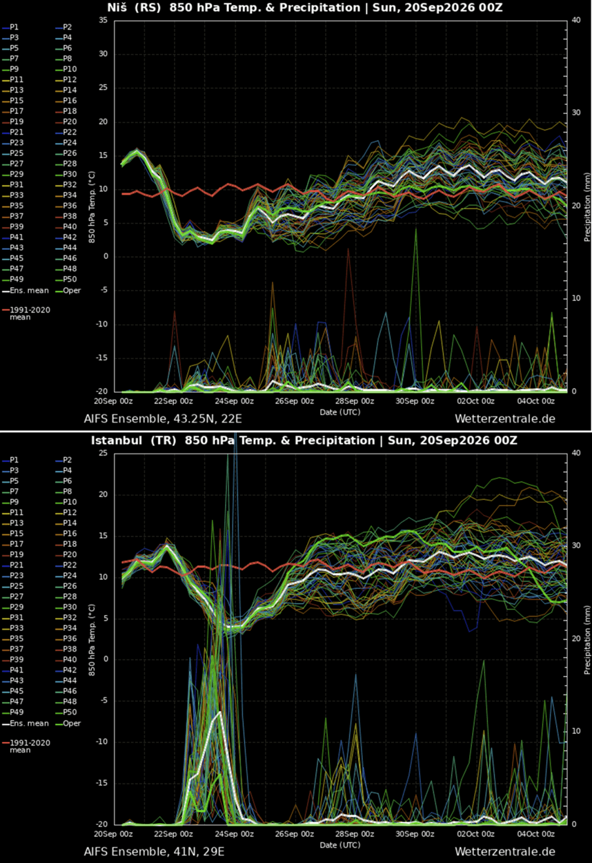
The leading edge of the polar front pushed aggressively southward on Tuesday. Surface temperatures across the Balkan Peninsula plummeted violently. Serbia, Bosnia, Romania, and Bulgaria bore the immediate brunt of the transition, recording daytime highs 10°C to 15°C below long-term climate averages. Meteogram models for cities such as Niš, Serbia, highlighted a near-vertical cliff in temperature curves. Nocturnal clearing behind the front allowed radiational cooling to take hold, setting up the first widespread morning frost event in lower valleys and agricultural plains from the Baltics down to the central Balkans.
Wednesday: Expansion into Greece and Western Turkey
The core of the upper-level cold wave shifted further south and east by Wednesday, overspreading the southern Balkans, Greece, the Aegean Sea, and the Black Sea basin. Western Turkey experienced the most pronounced thermal anomalies of the event, with temperatures plunging 12°C to 16°C below seasonal norms. High-altitude environments in the Carpathians and Northern Balkans registered a drastic lowering of the freezing level, converting rain to the season’s maiden high-altitude snow flurries. Active tourism sectors in Greece and Turkey experienced a sudden, brisk reality check as late-summer beach weather was abruptly replaced by unseasonably cool, windy conditions.
Thursday and Beyond: Gradual Dissipation and the Return of Ridging
By late week, the core of the polar low is forecast to push out into the eastern Mediterranean and the Middle East, losing its punch. In its wake, the extensive upper-level ridge currently anchored over Western Europe will begin to expand eastward once more, gradually moderating temperatures across Central and Eastern Europe as the calendar nears the end of September.
Supporting Data and Meteorological Analysis
To fully understand the mechanics of this weather anomaly, meteorologists look to key upper-air and surface parameters that define the scale of the cold pool.
Synoptic Architecture
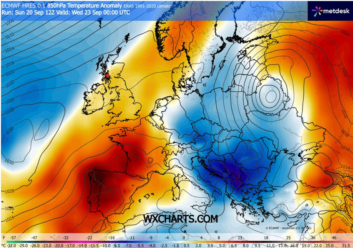
The structure of the atmosphere this week is defined by a classic blocking dipole. Western Europe remains trapped under a warm, higher-than-normal pressure anomaly, while Eastern Europe acts as a sink for Arctic air. The juxtaposition of the Western European/Scandinavian Ridge and the Eastern European trough creates an unyielding meridional jet stream trajectory. This pattern acts as an unhindered highway for polar air masses to bypass the moderating influences of the Atlantic Ocean and penetrate deep into continental landmasses.
850 hPa Temperature Anomalies
At the 850 hPa level (approximately 1,500 meters above sea level), the thermal anomaly maps paint a striking picture. Values are persistently 6°C to 10°C below the climatological mean for late September. This mid-level cold pool is essential because it prevents air parcels from warming adiabatically as they descend, ensuring that the biting chill reaches the surface intact.
Surface Reflections and Meteograms
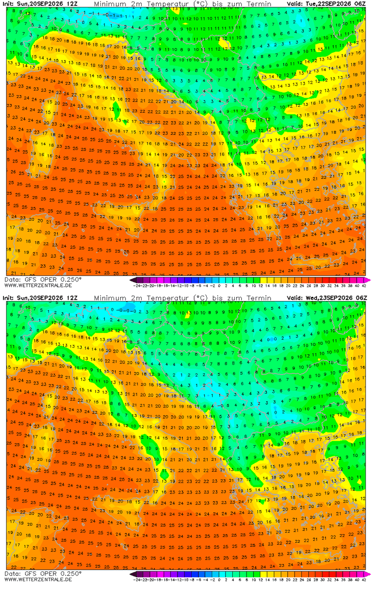
Meteogram analyses—such as those generated for Niš, Serbia, and Istanbul, Turkey—illustrate a textbook drop in temperatures. Following days of persistent, mild, late-summer warmth, the lines representing both 2-meter temperatures and dew points drop sharply between Monday night and Wednesday. Minimum temperature charts indicate that nocturnal lows across interior valleys will dip into the low single digits, crossing the crucial 0°C threshold at ground level to form frost. Maximum temperatures in areas like the south-central Balkans and western Turkey will struggle to climb past the upper teens and low twenties—figures more typical of late October than the height of the autumn transition.
Implications
While transient, an early-season Arctic blast of this magnitude carries substantial implications across multiple sectors, ranging from agriculture and energy to regional tourism.
Agricultural Vulnerability
The most immediate and critical concern is the threat to agriculture. Because the preceding weeks have been characterized by persistent warmth, crops, vineyards, and late-harvest vegetables across the Baltic states, Romania, Bulgaria, and the Balkan interior have not yet undergone natural hardening against cold stress. The sudden arrival of morning frost in low-lying agricultural basins poses a severe risk of crop damage, particularly to unharvested fruits, vegetables, and tender garden plants. Farmers in vulnerable regions have been forced to scramble to implement frost-protection measures, such as irrigation or smoke generation, to save sensitive yields.
Energy and Infrastructure
The sudden drop in temperatures triggers an equally sudden pivot in domestic energy consumption. Households that had not yet turned on heating systems are experiencing indoor chill, driving a sharp, albeit short-lived, spike in electricity and gas demand for residential heating. Municipalities and utility providers must adjust rapidly to the sudden thermal swing, though the brief duration of the cold snap mitigates the risk of long-term grid strain.
Tourism and Local Economy
In regions heavily reliant on the shoulder-season tourism economy—most notably coastal Greece, the Aegean islands, and the resort areas of western Turkey—the polar intrusion acts as a sudden disruptor. Millions of international and domestic tourists enjoying late-September holidays are seeing outdoor leisure, swimming, and beach activities curtailed by brisk northerly winds and unseasonably cool daytime temperatures. Outdoor hospitality sectors are forced to transition rapidly from open-air dining and beach setups to indoor facilities.
Broader Climatic Context
This aggressive September cold intrusion also arrives amid heightened scientific interest in the upcoming cold season. Recent long-range meteorological analyses indicate that a new Polar Vortex is beginning to emerge over the North Pole, carrying potential disruption risks for the winter of 2026/2027. While this week’s event is a localized, mid-tropospheric pattern adjustment rather than a direct winter vortex collapse, it serves as a powerful reminder of the atmosphere’s capacity for rapid, high-amplitude shifts.
As the upper-level ridge prepares to rebuild over Central and Eastern Europe late this week, the memory of this sharp Arctic slap will fade, returning the continent to a more quiescent weather regime. However, it permanently closes the book on summer 2026, forcefully ushering in the realities of the autumn season.
