

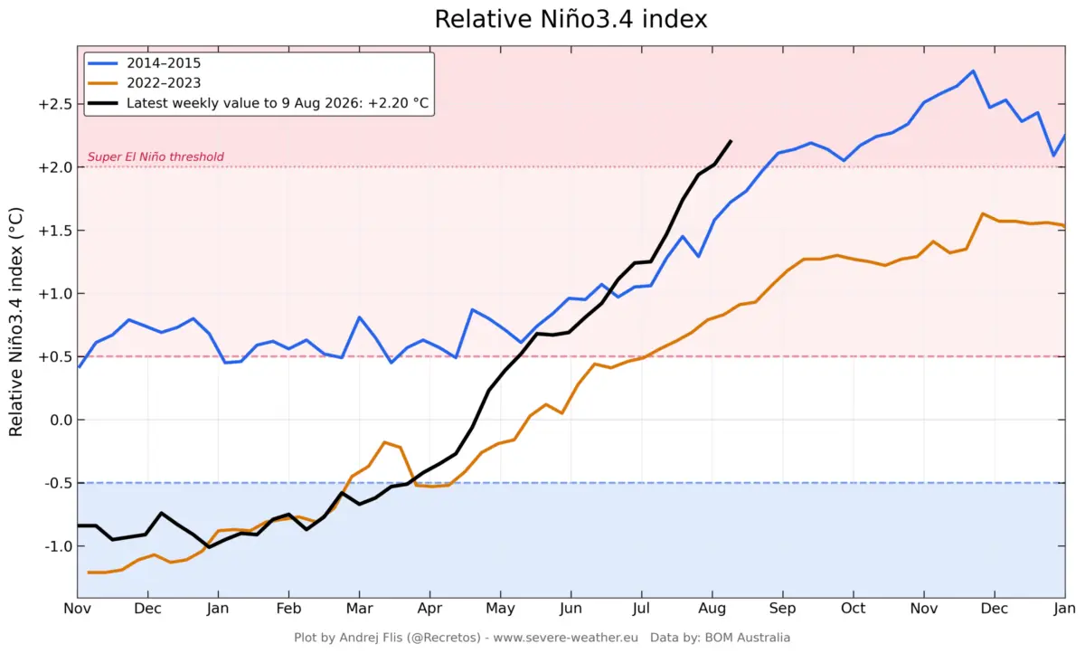
GLOBAL CLIMATE OBSERVATION — A rapidly strengthening Super El Niño event is unfolding across the tropical Pacific Ocean, sending shockwaves through long-range meteorological models and threatening to rewrite seasonal forecasts for late 2026 and early 2027. Fueled by record-breaking subsurface heat and unprecedented westerly wind anomalies, leading climate agencies are tracking an event that is accelerating faster than the historic 2015–2016 cycle.

Meteorologists and long-range forecasters warn that this powerhouse climate driver is already forcing an atmospheric response months ahead of its anticipated peak. As ocean heat content reaches extreme levels, governments, agricultural sectors, and energy markets across North America and Europe are bracing for a highly amplified, volatile weather regime for Fall 2026 and Winter 2026/2027.
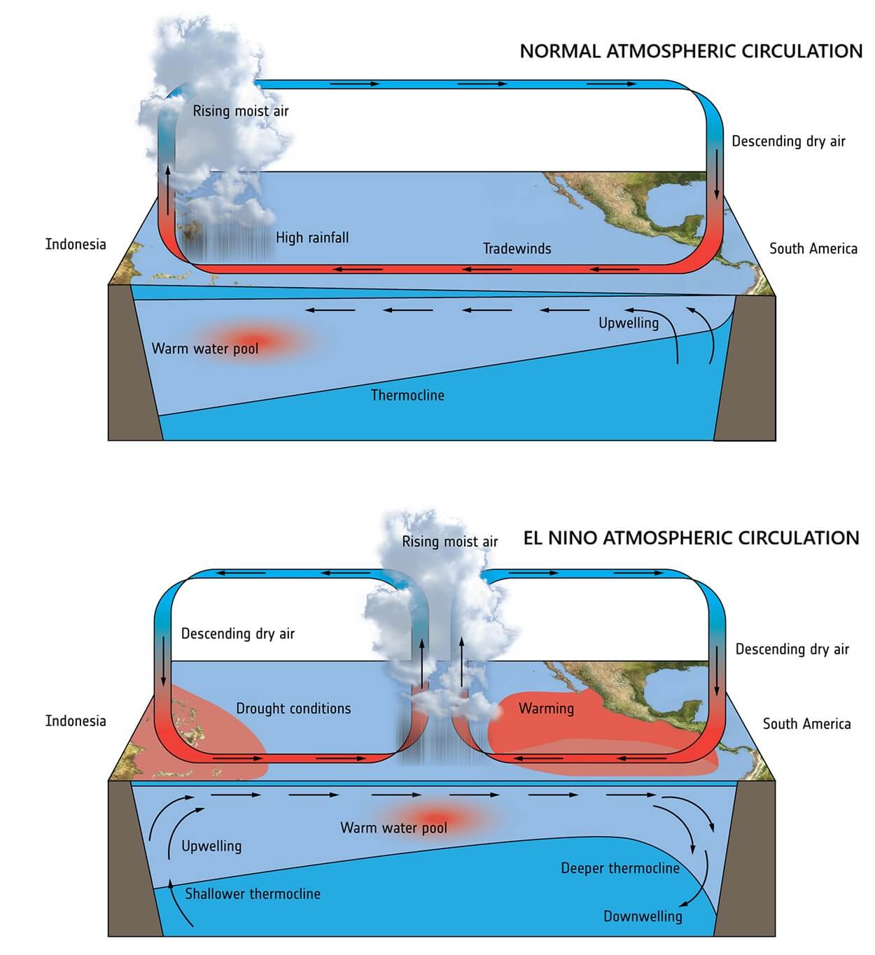
Main Facts: The Anatomy of an Extreme ENSO Event
The El Niño-Southern Oscillation (ENSO) is currently locked into a rapidly escalating positive phase, transitioning swiftly from moderate thresholds into an extreme "Super" status.
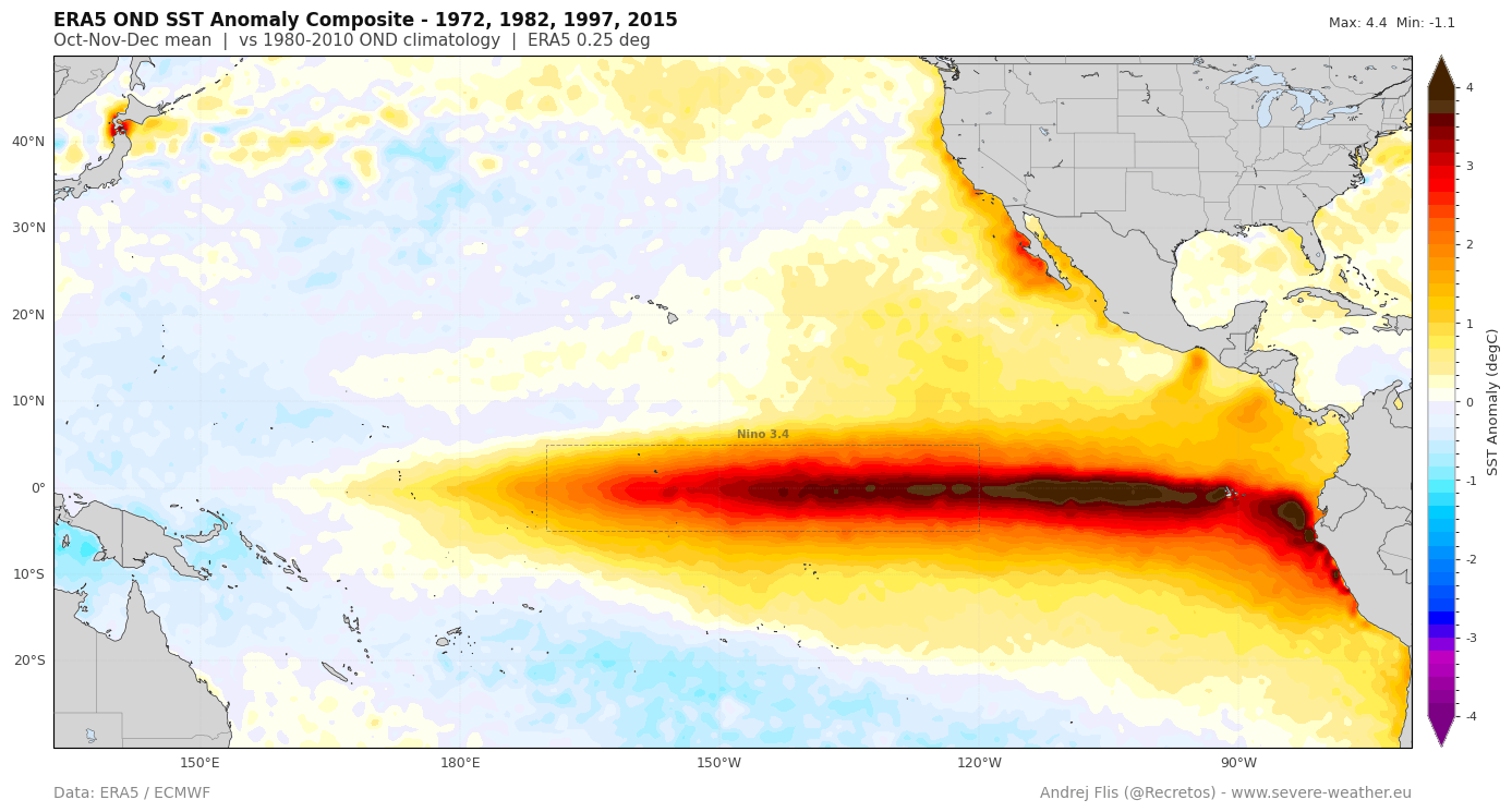
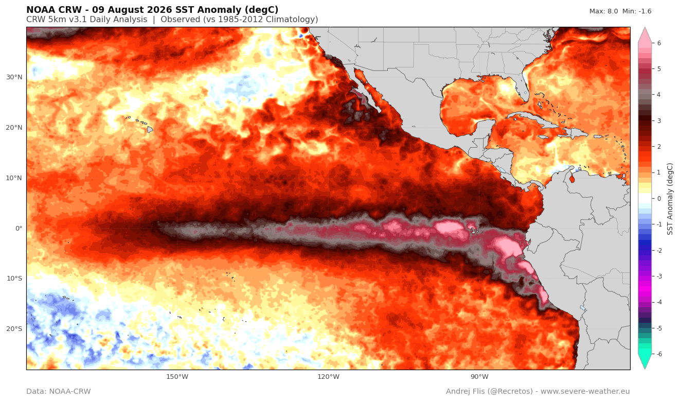
- Record-Breaking Development: Recent oceanographic data confirms that sea surface temperature anomalies in the central and eastern tropical Pacific have surged significantly, with localized peaks exceeding 5°C to 6°C above normal.
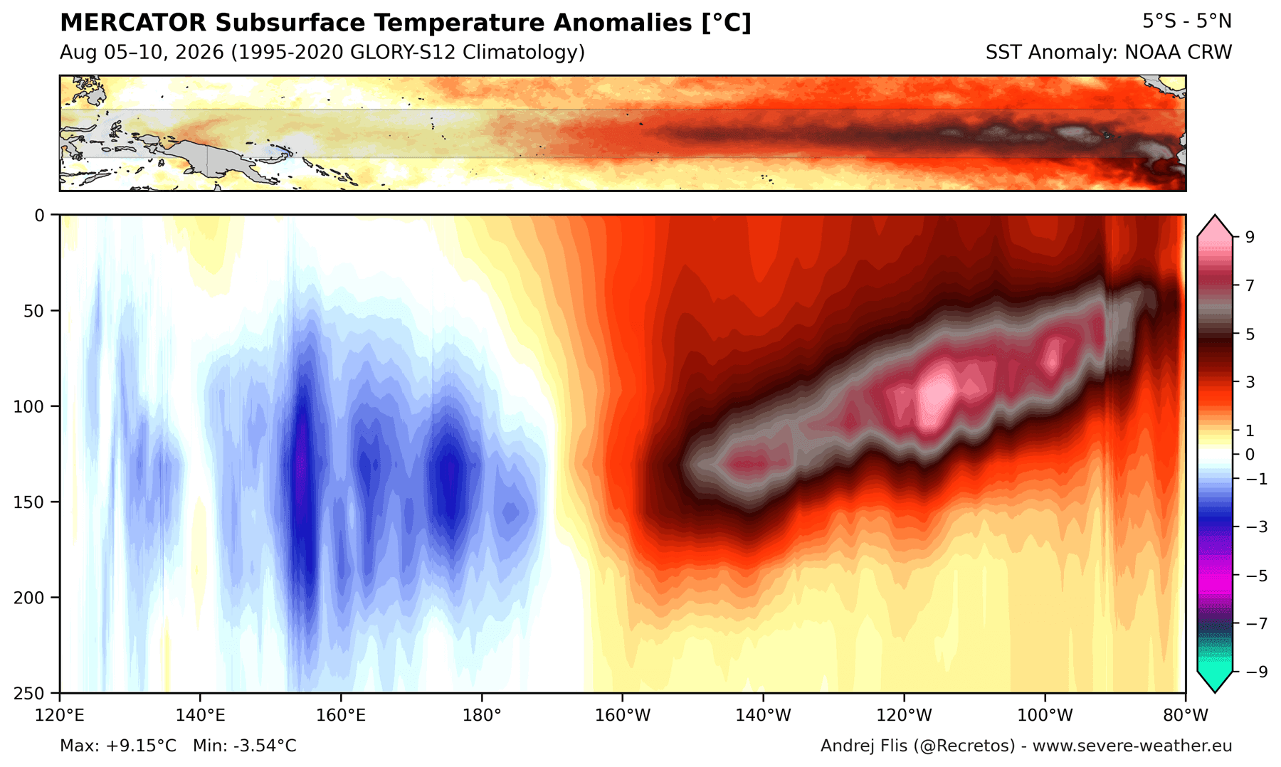
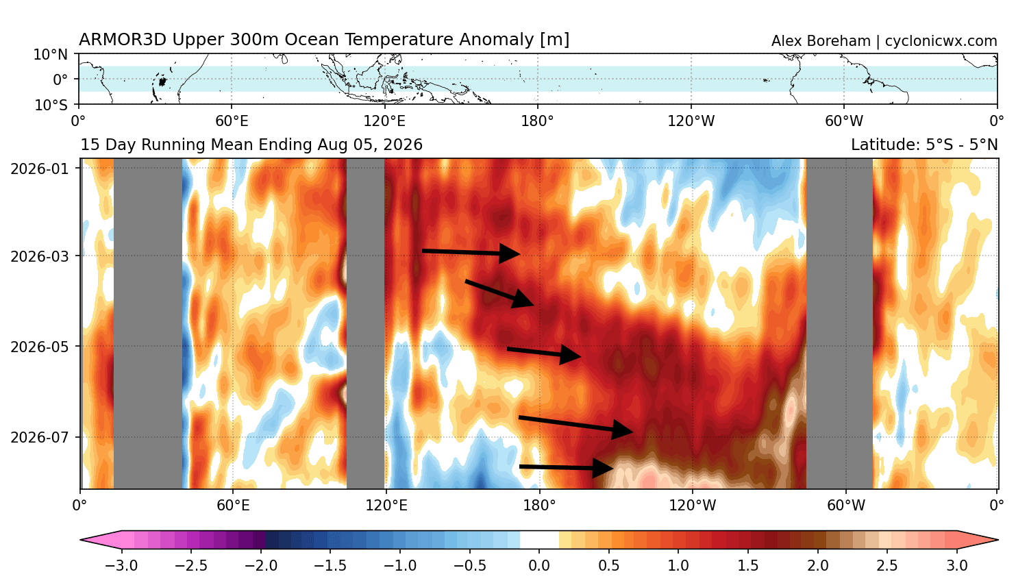
- The Subsurface Engine: Beneath the ocean surface, a powerful downwelling Kelvin wave—carrying subsurface temperature anomalies exceeding 9°C (16°F) down to 250 meters—is currently propagating eastward, guaranteeing a continuous thermal supply to the surface well into the winter months.
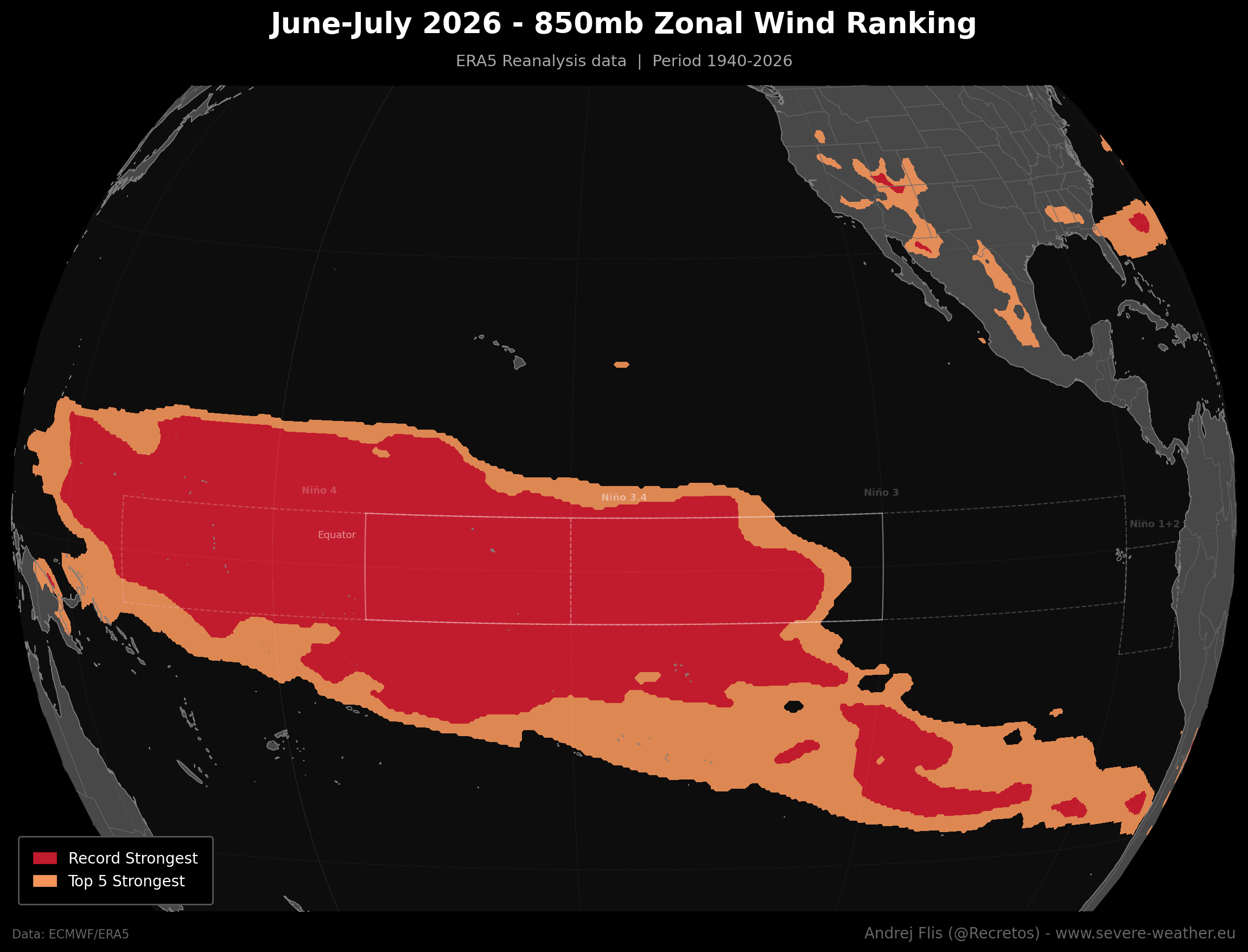
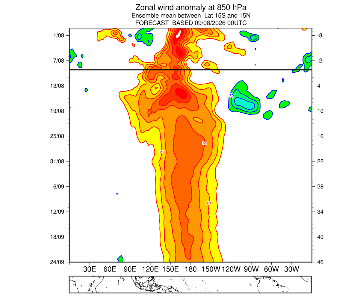
- Unprecedented Wind Anomalies: ERA5 reanalysis data reveals that low-level westerly wind bursts across the equatorial Pacific hit record highs during June and July 2026, marking the most substantial trade wind collapse across an 86-year dataset.
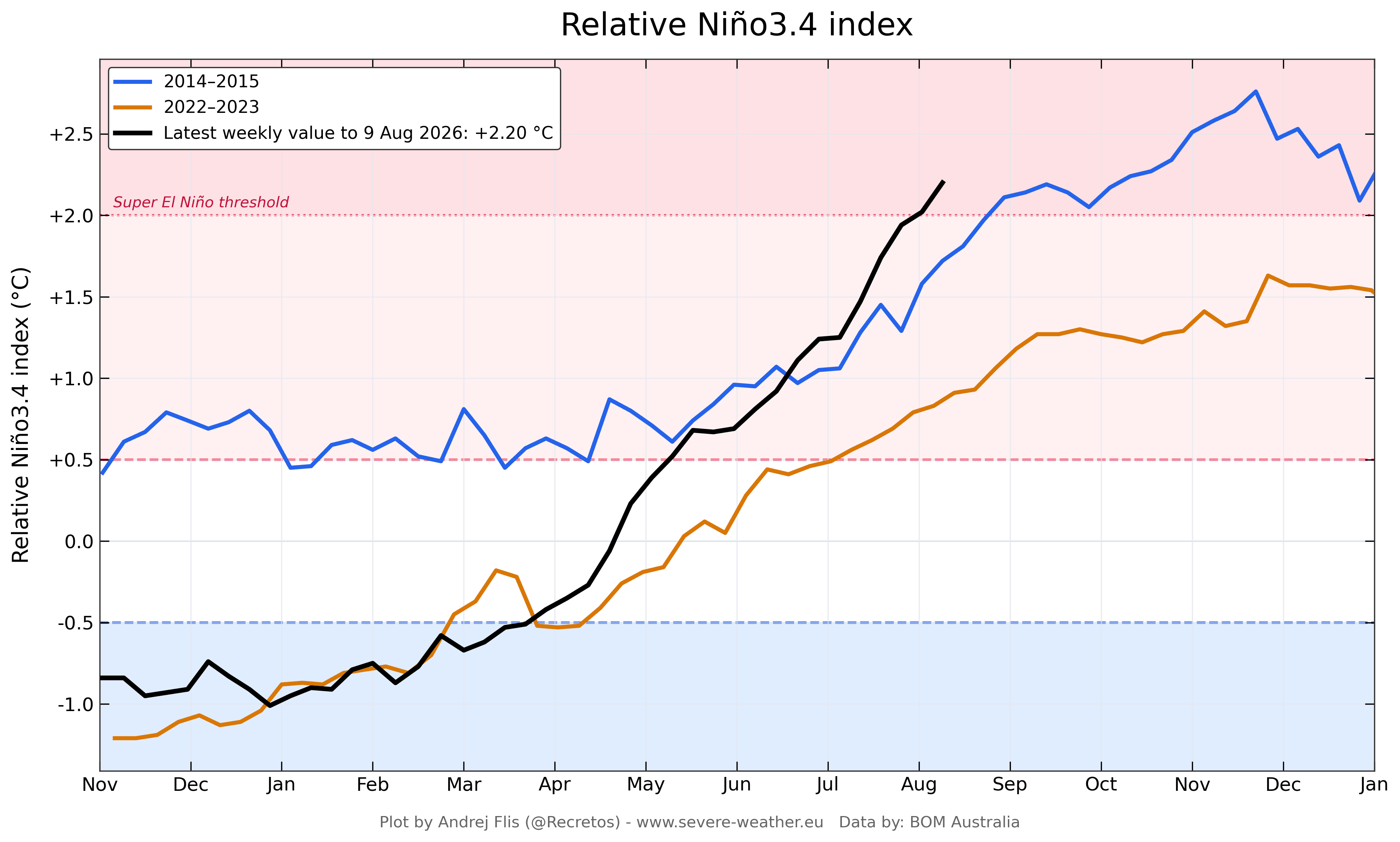
- Atmospheric Lockdown: The Multivariate ENSO Index (MEI) recorded an unprecedented bi-monthly value of +2.4 for June-July 2026—a massive 3.4-point jump from a cool -1 in early spring, establishing a semi-permanent atmospheric standing wave across the globe.
Chronology of Development: From Spring Acceleration to Late-Year Projections
The trajectory of the 2026–2027 Super El Niño has defied typical seasonal model simulations, catching many automated forecasting systems off guard due to the chaotic nature of daily and weekly wind bursts.
Spring to Summer 2026: The Ignition Phase
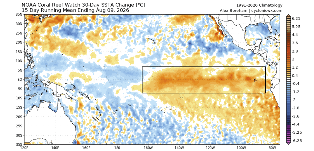
As the Northern Hemisphere transitioned out of spring, numerical weather prediction models—including the ECMWF and NOAA’s NMME—began detecting subtle warming signals in the central Pacific. However, it was not until June and July that sustained westerly wind bursts dismantled normal trade wind patterns. This atmospheric shift piled up warm water in the western Pacific, launched a massive Kelvin wave toward the Americas, and triggered an explosive acceleration in sea surface temperatures.
August and September 2026: Deepening Into Historic Territory
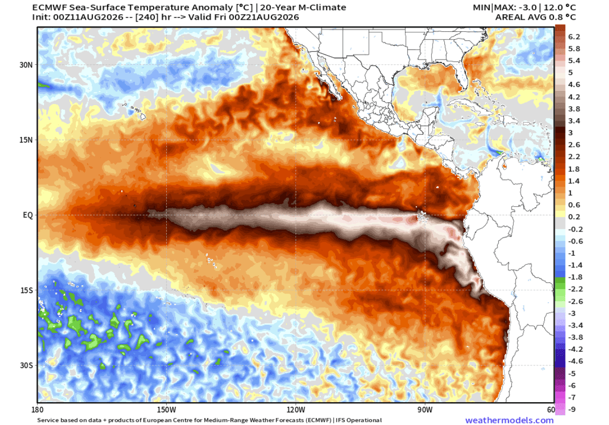
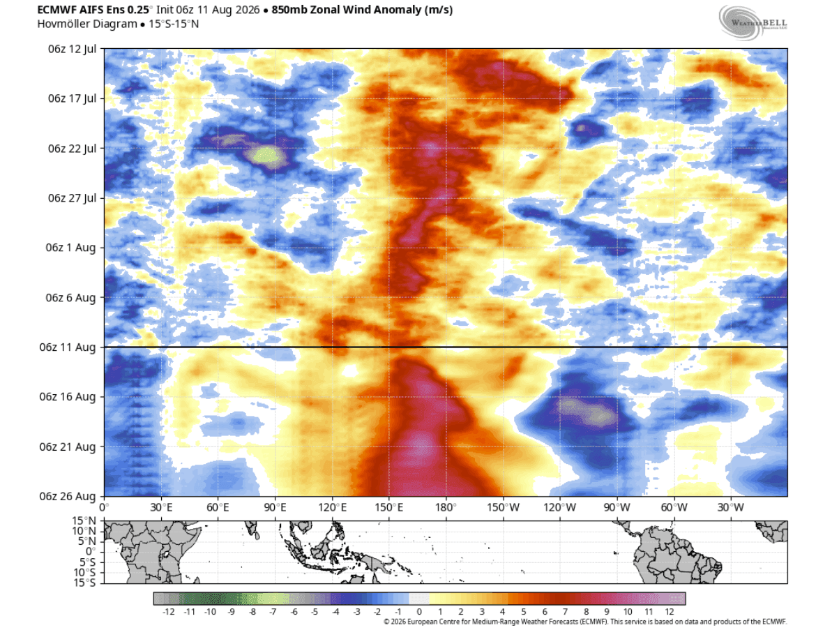
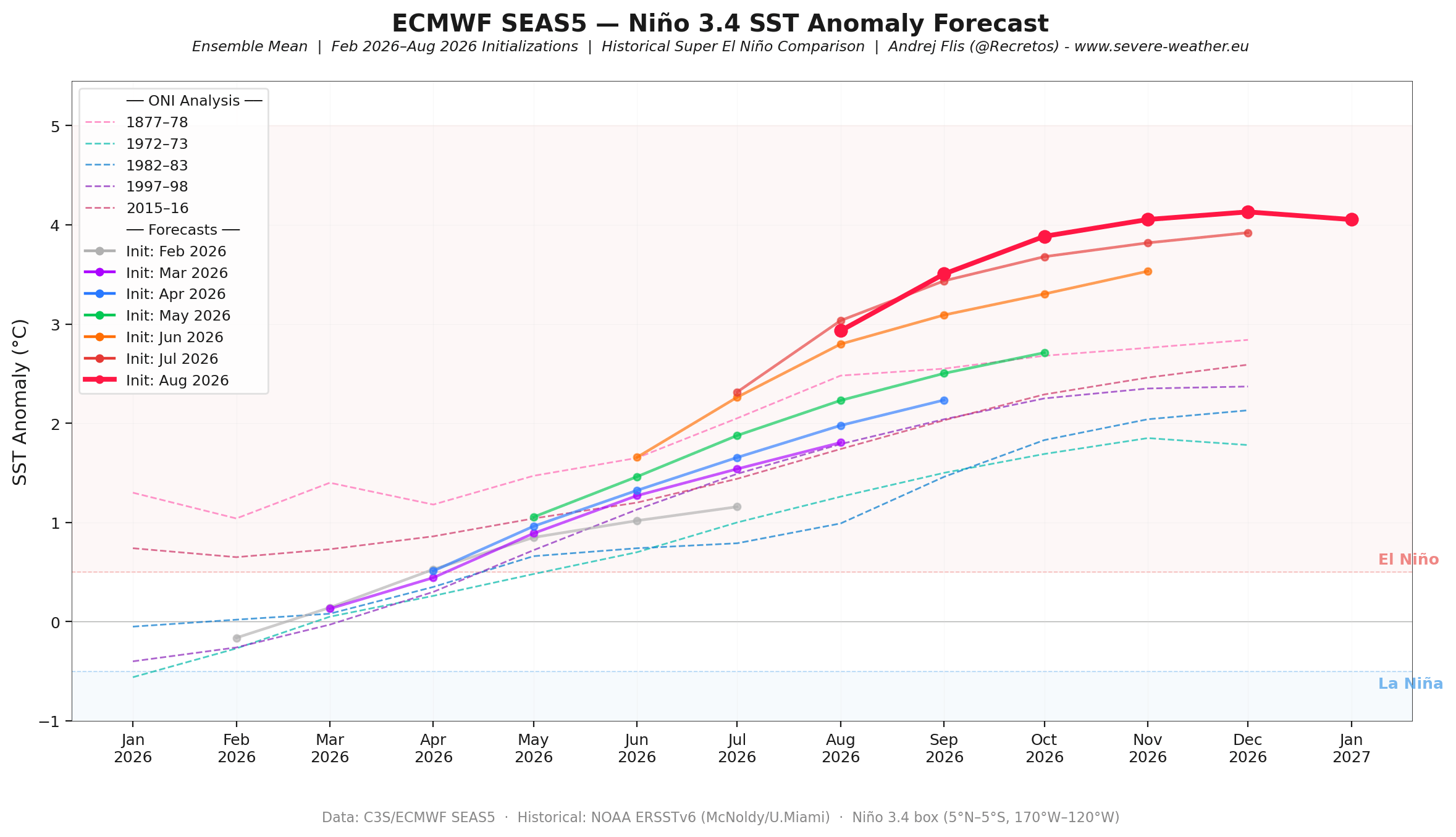
By late summer, consecutive model runs from the European Centre for Medium-Range Weather Forecasts (ECMWF) continuously pushed projected peak anomalies higher. Unlike typical El Niño events that build at a moderate pace, the 2026 cycle bypassed standard thresholds, matching or exceeding the initial growth rates of the legendary 2015–2016 event. Extended ensembles indicate that robust ocean-atmosphere coupling will sustain these westerly wind anomalies through September, cementing the event’s "Super" classification.
November and December 2026: The Projected Peak
Global seasonal forecasts project the El Niño to reach its maximum intensity between November and December 2026. During this window, extreme ocean temperature anomalies are expected to blanket more than 10% of the global ocean surface, driving profound disruptions in global jet stream configurations.
Supporting Data: Oceanic and Atmospheric Diagnostics
To understand the sheer magnitude of this meteorological anomaly, scientists rely on a multi-layered analysis of ocean heat, wind patterns, and atmospheric pressure configurations.
Subsurface Thermal Dynamics
While surface waters capture public attention, climatologists emphasize that the true engine of a Super El Niño lies underwater. NOAA’s Coral Reef Watch (CRW) and ocean heat content models display an expanding ribbon of extreme warmth down to 300 meters depth. The ongoing Kelvin wave acts as a conveyor belt of thermal energy, slowly rising to the surface in the eastern Pacific and maintaining an unyielding anomaly that defies standard seasonal cooling cycles.
The Breakdown of Trade Winds
The persistence of low-level westerly wind anomalies is the primary catalyst differentiating a standard El Niño from a Super event. Historical zonal wind rankings confirm that June and July 2026 produced the strongest westerly anomalies in nearly nine decades. This broad collapse of the Walker circulation—the tropical east-to-west atmospheric conveyor belt—has locked the atmosphere into a persistent standing wave characterized by suppressed rainfall and high pressure over the Indian Ocean, paired with intense rising air and low pressure over the central and eastern Pacific.
Official Responses and Meteorological Outlooks
As the data solidifies, major international meteorological centers have updated their long-range outlooks, highlighting distinct impacts for the United States, Canada, and Europe.
United States and Canada: Fall Transition and Winter Amplification
The atmospheric imprint of the Super El Niño is manifesting unusually early. The Fall 2026 forecast exhibits characteristics normally reserved for deep winter:
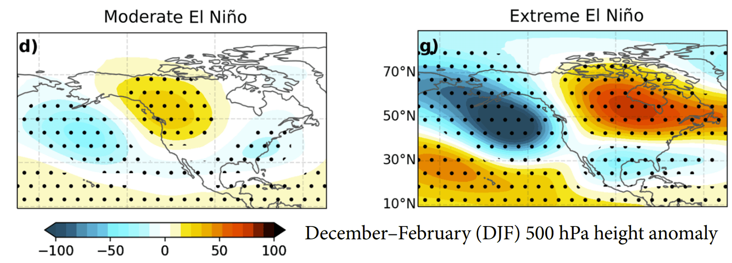
- Pressure Patterns: A prominent high-pressure blocking ridge is establishing itself over Canada, paired with a persistent low-pressure trough in the North Pacific and an active storm track slicing across the southern United States.
- Temperature Trends: Above-normal autumn temperatures are favored across western and northern Canada and the northern U.S. Meanwhile, the southern tier of the United States can expect near-normal temperatures driven by increased cloud cover and precipitation.
- Winter 2026/2027 Extremes: ECMWF and CFSv2 winter outlooks point toward a highly amplified late-winter pattern. By February 2027, northern blocking is projected to force a vigorous, moisture-laden low-pressure track straight through the central, southern, and eastern U.S., potentially introducing significant cold anomalies and high-impact winter storm configurations.
- Snowfall Potential: Snowfall totals are projected to be below average across the Pacific Northwest, northern Great Lakes, and southern Canada. Conversely, the Central Plains, Midwest, Mid-Atlantic, and interior Northeast face an elevated risk of heavy snowfall and ice events as southern moisture streams collide with periodic drops of Canadian air.
Europe: A Milder, Atlantic-Driven Season
While North America deals with dramatic jet stream buckling, Europe’s weather will be heavily influenced by downstream teleconnections.
- Pressure and Flow: Extended forecasts indicate that the North Atlantic low-pressure zone will extend its reach into northern and northwestern Europe. This setup encourages a dominant westerly and southwesterly flow across the continent.
- Temperature and Precipitation: Most of central, western, and southeastern Europe is favored to experience warmer-than-normal surface temperatures during the winter months. The robust westerly flow will also import substantial marine moisture, increasing precipitation potential across broad regions, while limiting widespread snowfall to higher elevations and the far northeast.
Implications for Global Weather and Infrastructure
The maturation of a Super El Niño carries cascading implications across multiple sectors of global society:
- Agricultural Planning: Farmers across the southern and eastern United States must prepare for heightened precipitation risks during harvest and planting seasons, while growers in the Pacific Northwest and western Canada monitor potential drought-enhancing dry anomalies.
- Energy Markets: Winter heating demand is projected to fluctuate wildly. While regions under the Canadian and northern U.S. ridges may experience lower-than-average heating costs, populations caught along the active southern and eastern storm tracks must prepare for potential grid strain caused by major winter storms and ice events.
- Global Climate Metrics: Beyond regional weather, a Super El Niño historically acts as a massive thermal release valve, pumping stored ocean heat into the lower atmosphere and temporarily supercharging global average surface temperatures.
As the 2026–2027 Super El Niño approaches its official peak in the closing months of the year, atmospheric scientists will continue monitoring real-time data feeds. With the atmospheric standing wave firmly locked in place, the world stands on the precipice of one of the most intensely studied and potentially impactful meteorological events of the modern era.
