

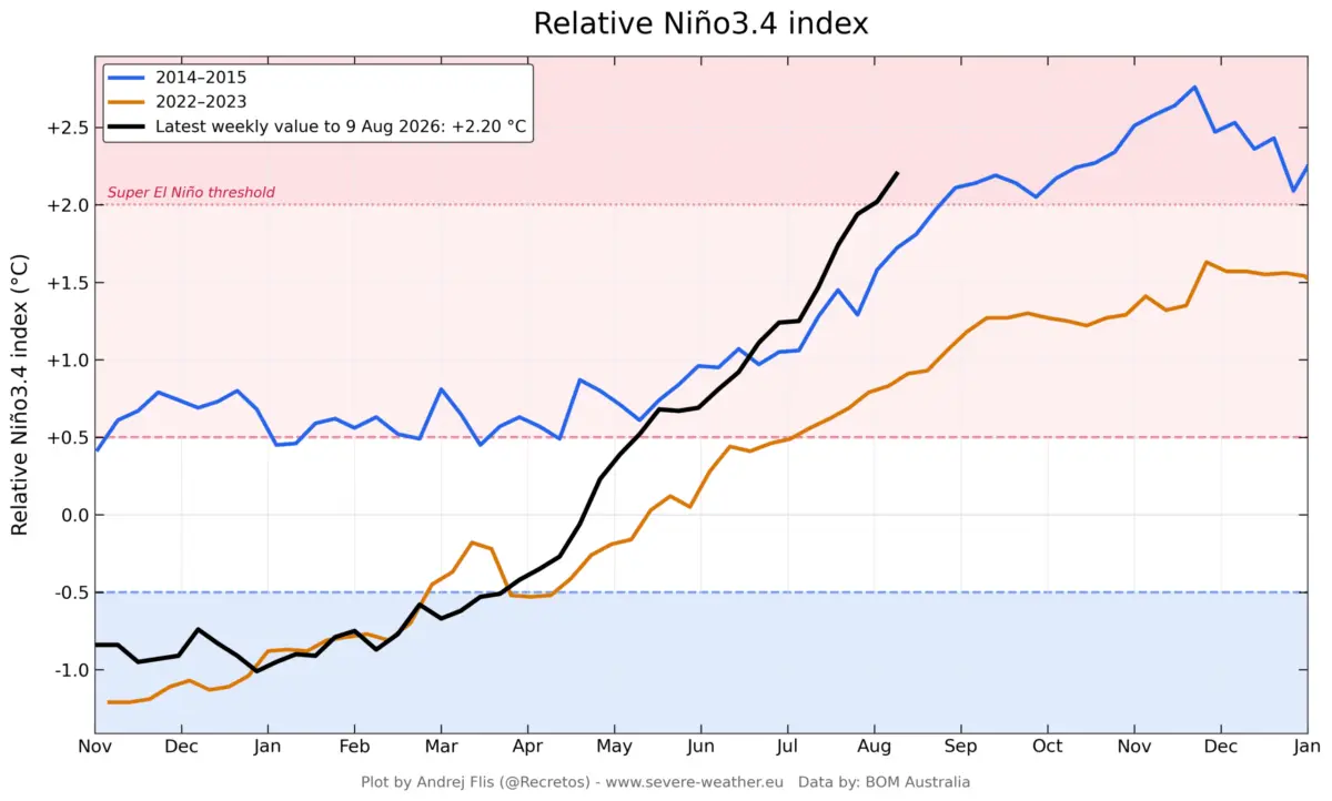
GLOBAL CLIMATE UPDATE — A rapidly developing "Super El Niño" is gathering unprecedented momentum across the tropical Pacific Ocean, shattering historical benchmarks for early-season growth. New atmospheric and oceanic data released this August reveal that the 2026/2027 event is accelerating faster and tracking stronger than the legendary 2015–2016 El Niño, pushing long-range global forecasts deeper into uncharted territory.

As meteorologists and climate modelers analyze the latest data from the European Centre for Medium-Range Weather Forecasts (ECMWF) and the National Oceanic and Atmospheric Administration (NOAA), the implications are clear: the unfolding climate phenomenon will fundamentally alter global atmospheric circulation, dictating severe shifts in weather patterns across the United States, Canada, and Europe for the upcoming Fall and Winter seasons.
1. Main Facts: The Anatomy of a Super El Niño
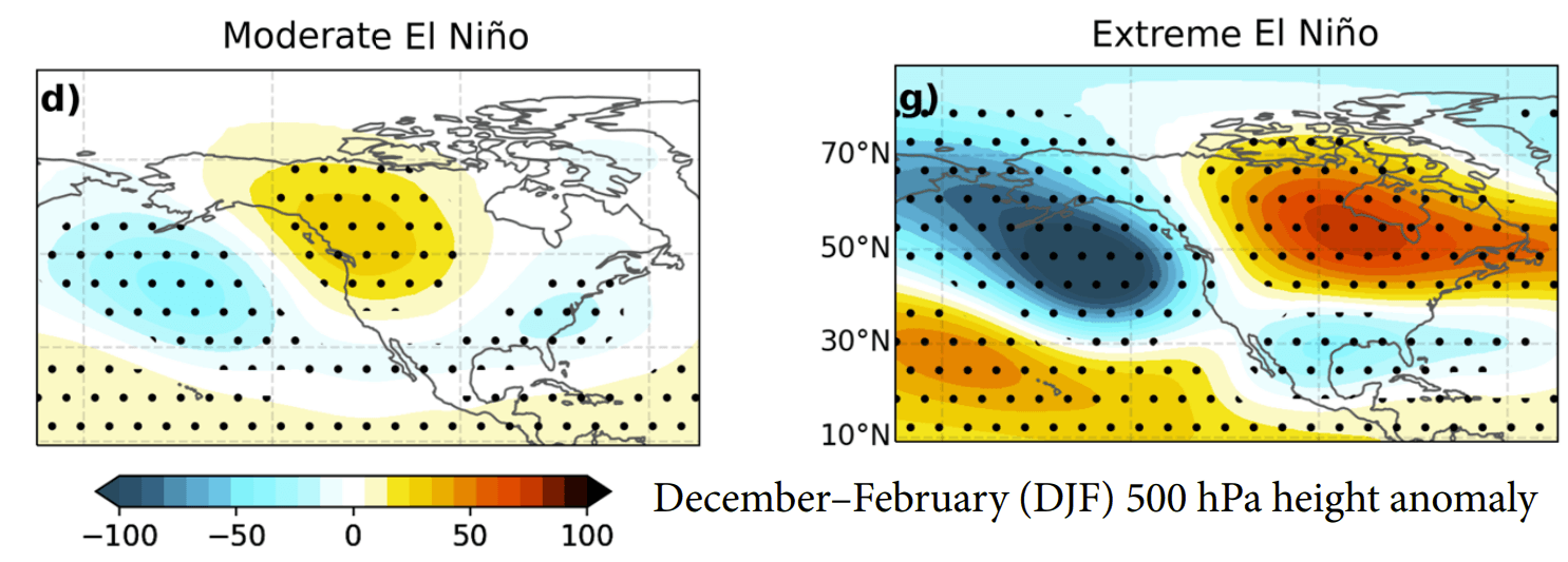
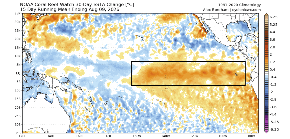
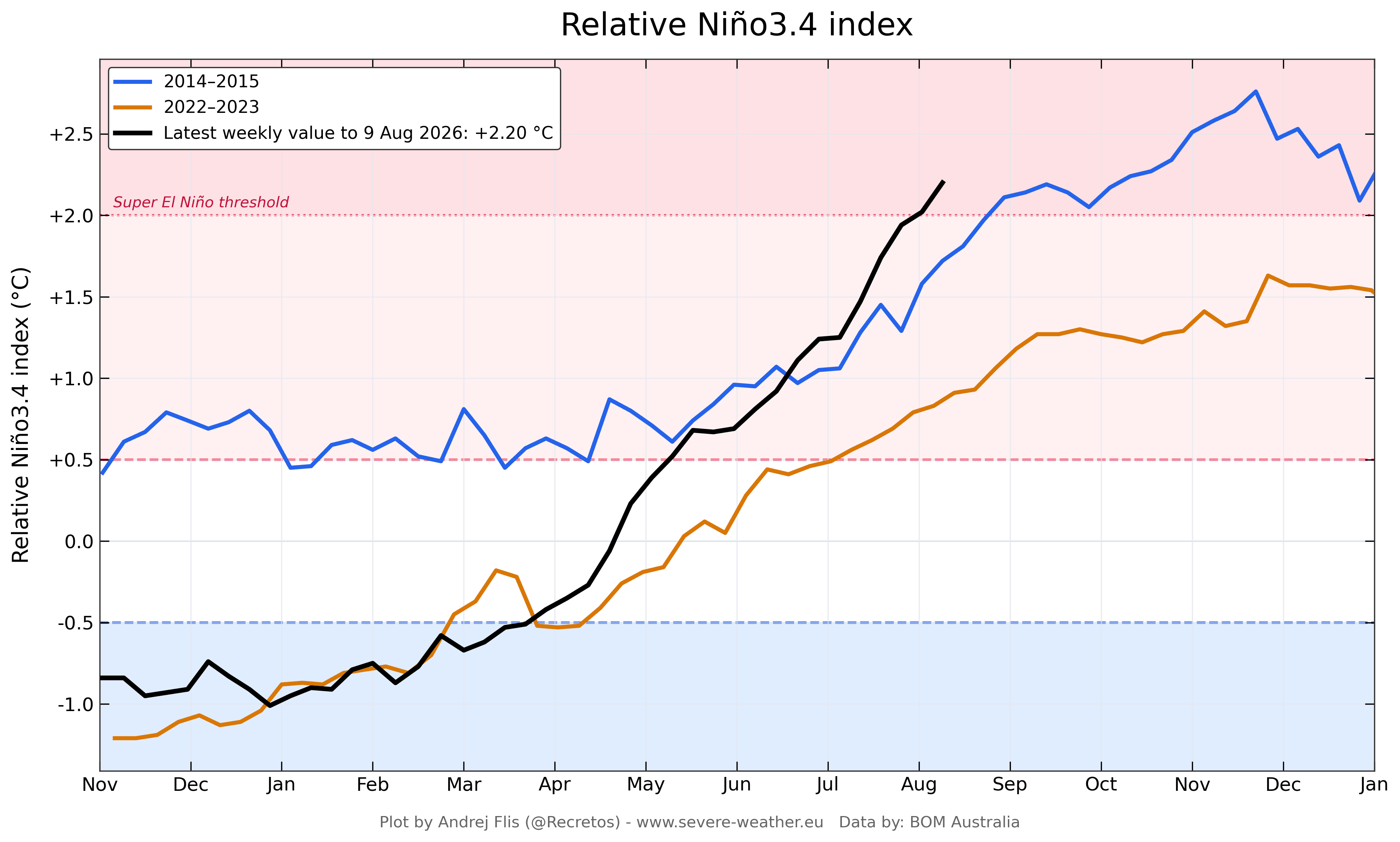
The El Niño-Southern Oscillation (ENSO) is currently transitioning aggressively into a powerful warm phase. While moderate El Niño events produce gentle wave patterns across the globe, a "Super El Niño" status—officially defined by sea surface temperature anomalies in the central and eastern tropical Pacific reaching or exceeding +2.0°C above the long-term average—triggers an extreme restructuring of the planetary jet stream.
Current observational data highlights several extraordinary metrics:
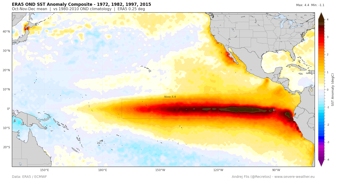
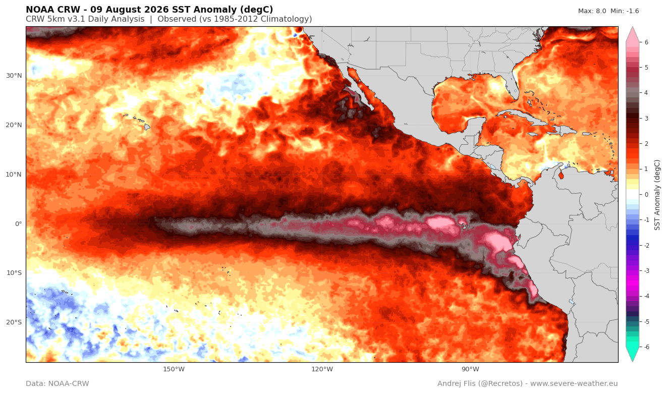
- Record Surface Warming: Sea surface temperature anomalies in the central and eastern Pacific have surged past +5.0°C to +6.0°C above normal in localized peak areas.
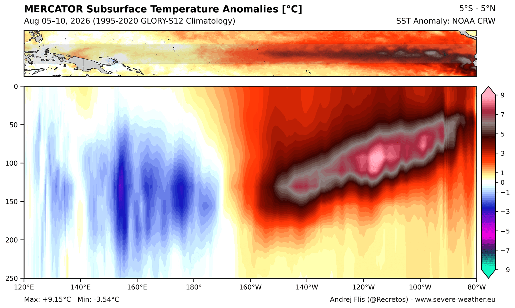
- Unprecedented Subsurface Heat: A massive downwelling Kelvin Wave is propagating eastward, carrying subsurface ocean heat anomalies exceeding +9.0°C (16°F) within the top 250 meters of the water column.
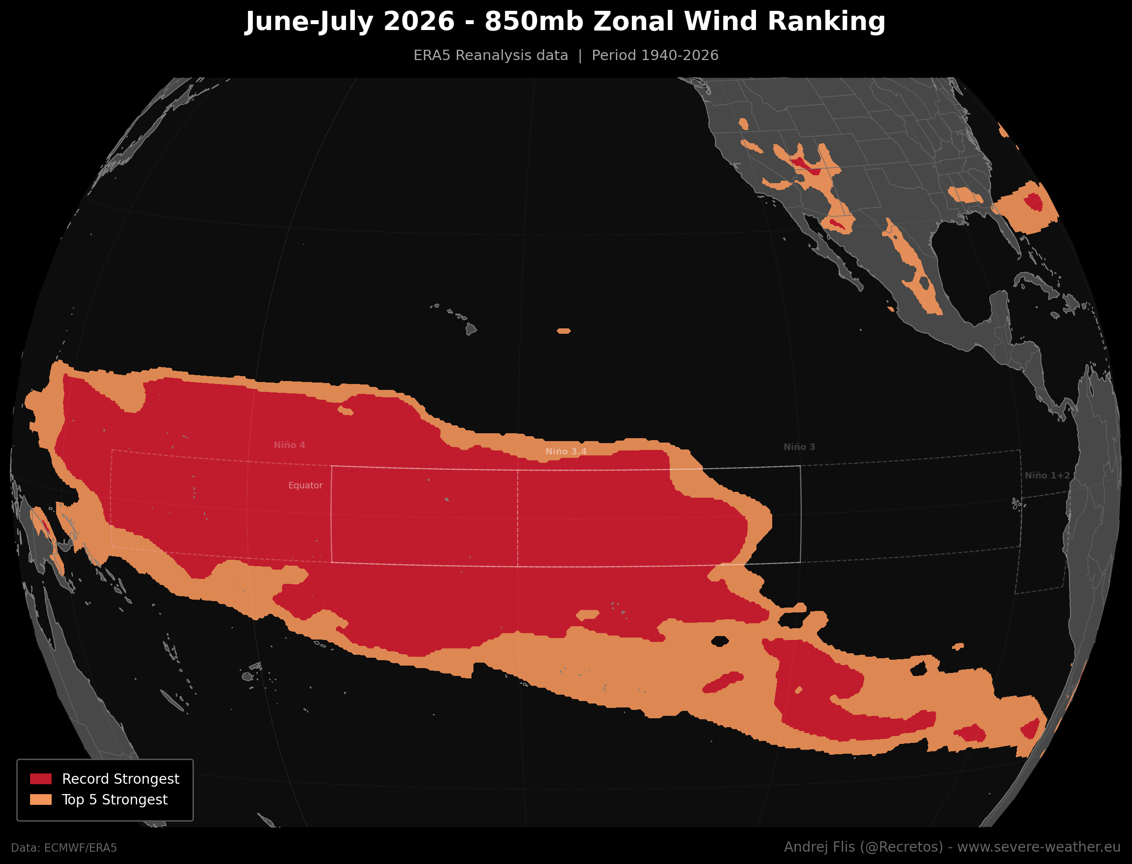
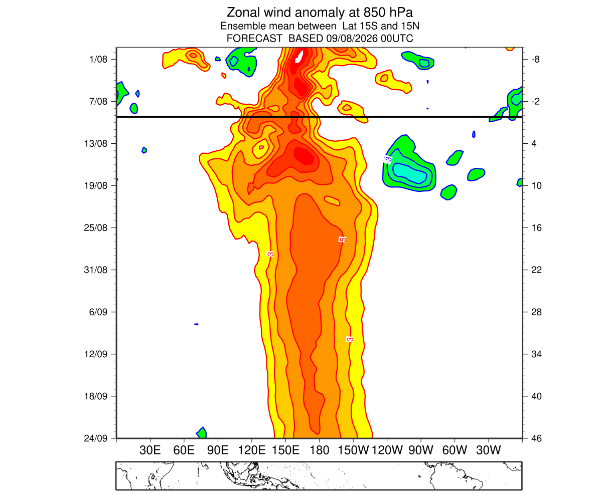
- Record Wind Anomalies: ERA5 reanalysis data shows that June and July 2026 recorded the strongest low-level westerly wind bursts across the equatorial Pacific in an 86-year observational dataset.
- Atmospheric Response: The Multivariate ENSO Index (MEI) jumped a staggering +3.4 points in just four bi-monthly periods, rocketing from a cool -1 in February-March to a record-high +2.4 for June-July.
2. Chronology of Development: From Spring Acceleration to Late-Summer Surges
The trajectory of the 2026/2027 Super El Niño has defied typical meteorological expectations through a compressed, highly aggressive development cycle:
- Early 2026 (Spring): Long-range models initially underestimated the event’s potential. Because seasonal computers struggle to simulate spontaneous daily westerly wind bursts, early-year model runs showed only a moderate ENSO event.
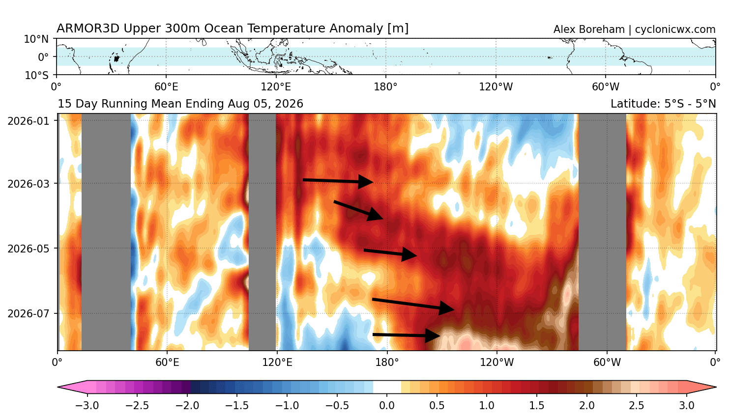
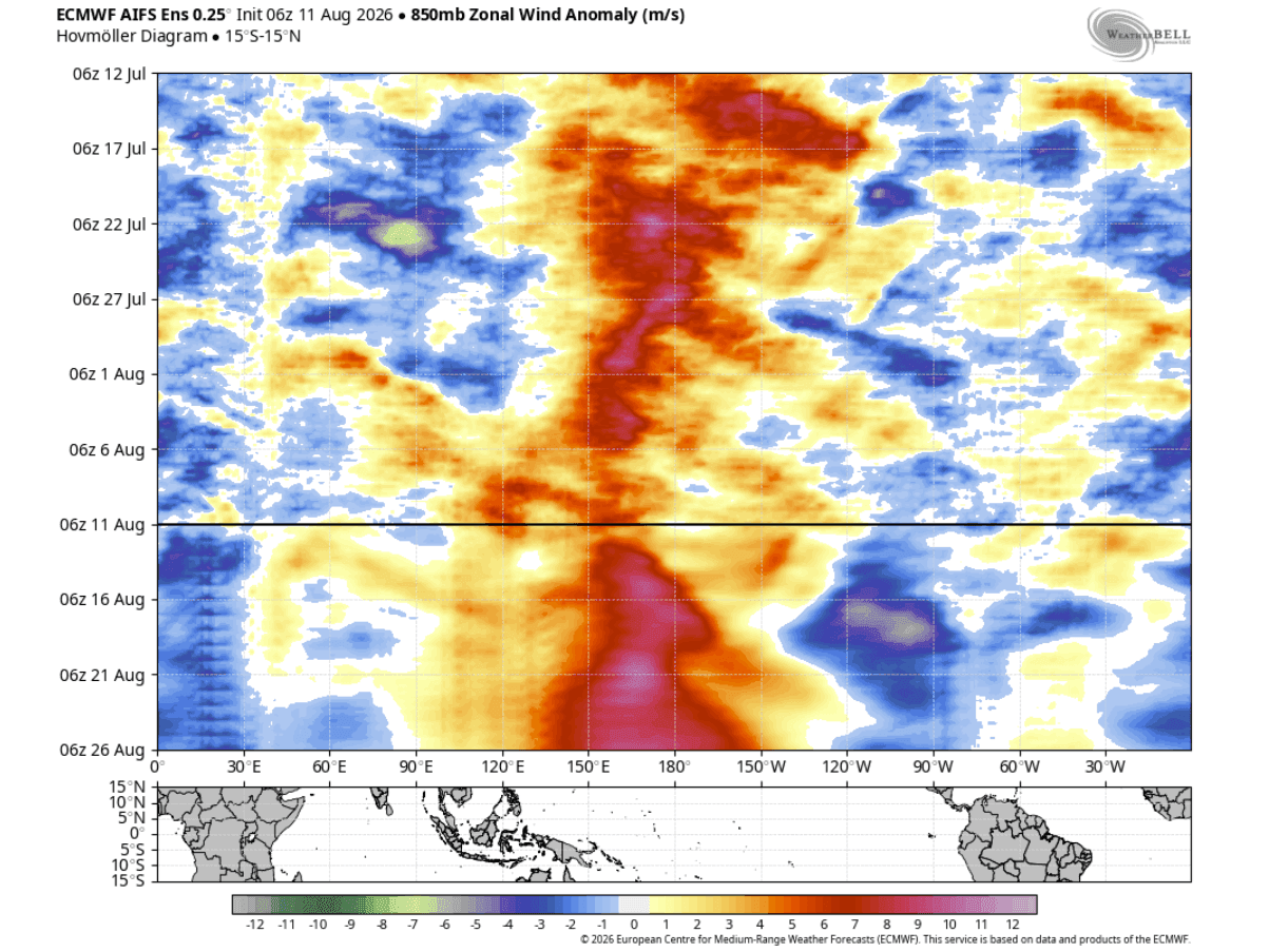
- June – July 2026: A sudden collapse of the equatorial trade winds generated historic westerly wind anomalies. These wind bursts piled warm water up in the western Pacific, launching a powerful Kelvin Wave eastward.
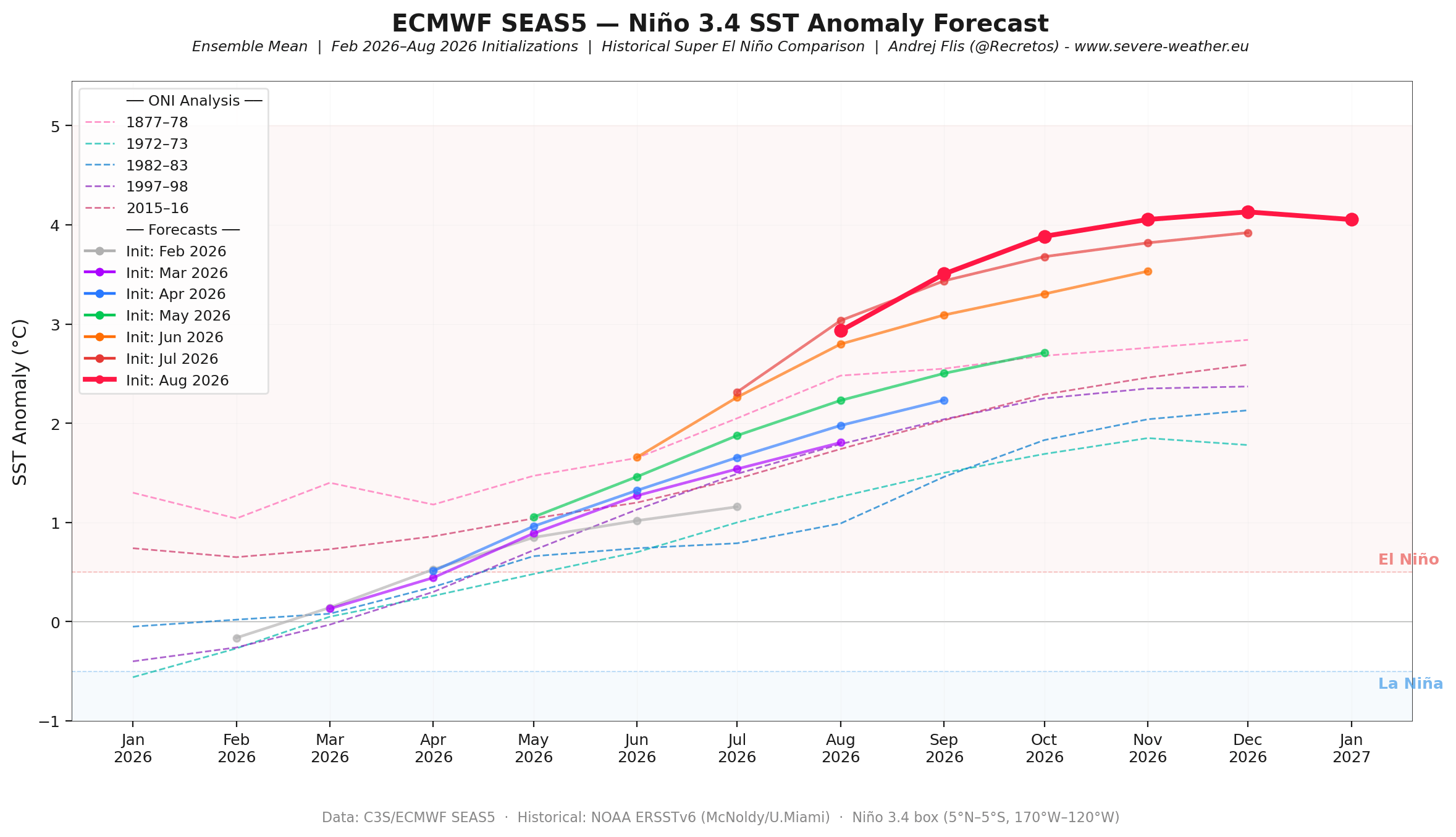
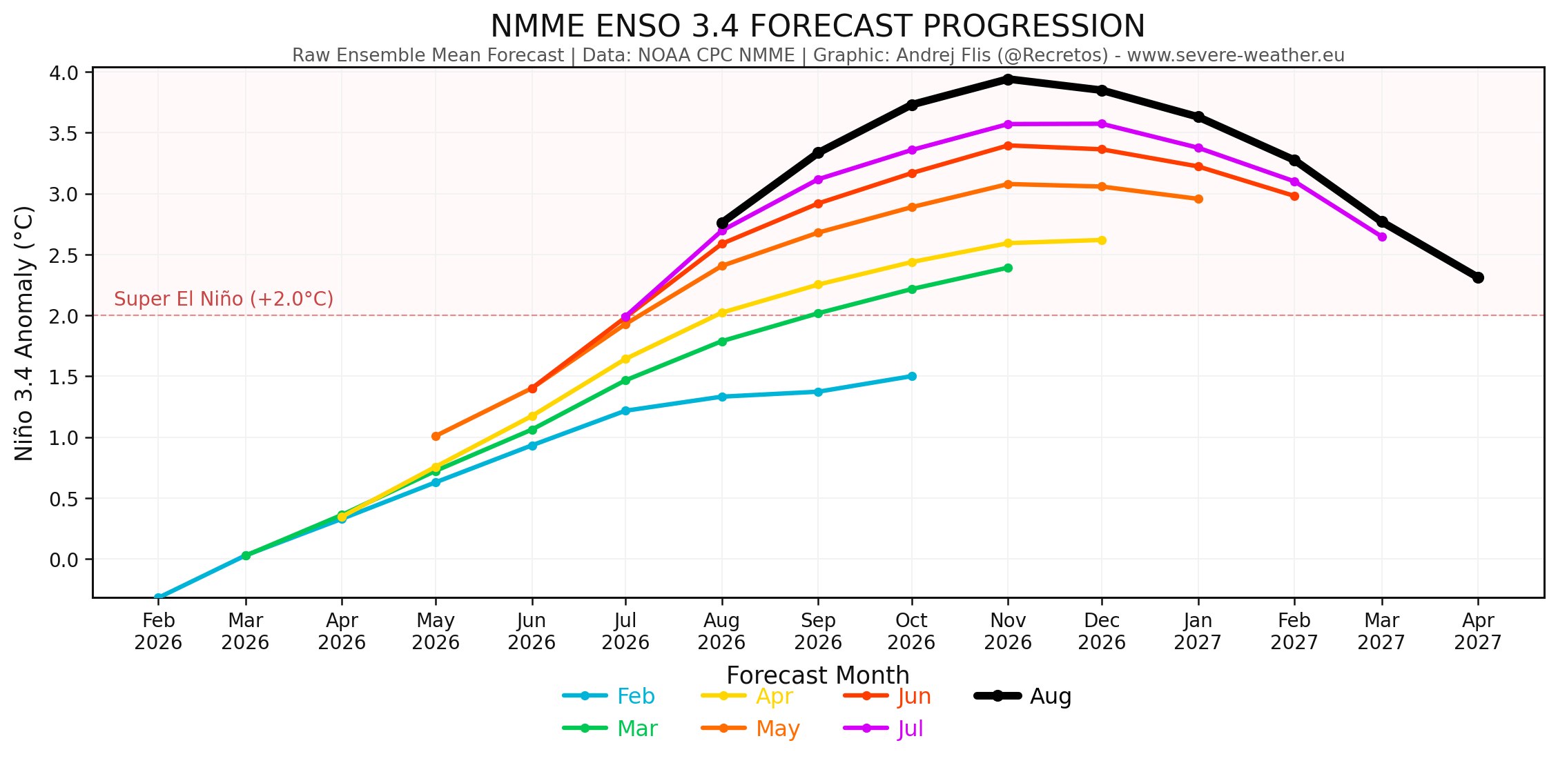
- August 2026 (Current Status): The subsurface Kelvin Wave has broken toward the surface, fueling explosive warming in the central and eastern Pacific. Consecutive ECMWF and NOAA NMME model updates have steadily trended toward a higher peak intensity, pushing projected surface anomalies well past the +3.0°C threshold.
- Late 2026 (Fall Projection): Meteorological indicators show that standard El Niño winter circulation patterns are developing prematurely, establishing an atmospheric standing wave months ahead of schedule.
- Late 2026 to Early 2027 (Winter Peak): Climatological models project the event to peak between November and December 2026, anchoring an amplified weather pattern that will dominate the Northern Hemisphere through February 2027.
3. Supporting Data: Ocean Heat, Kelvin Waves, and Atmospheric Coupling
Understanding the sheer magnitude of this event requires looking beneath the ocean’s surface. While surface temperatures capture public attention, subsurface dynamics serve as the engine of a Super El Niño.
The Kelvin Wave Engine
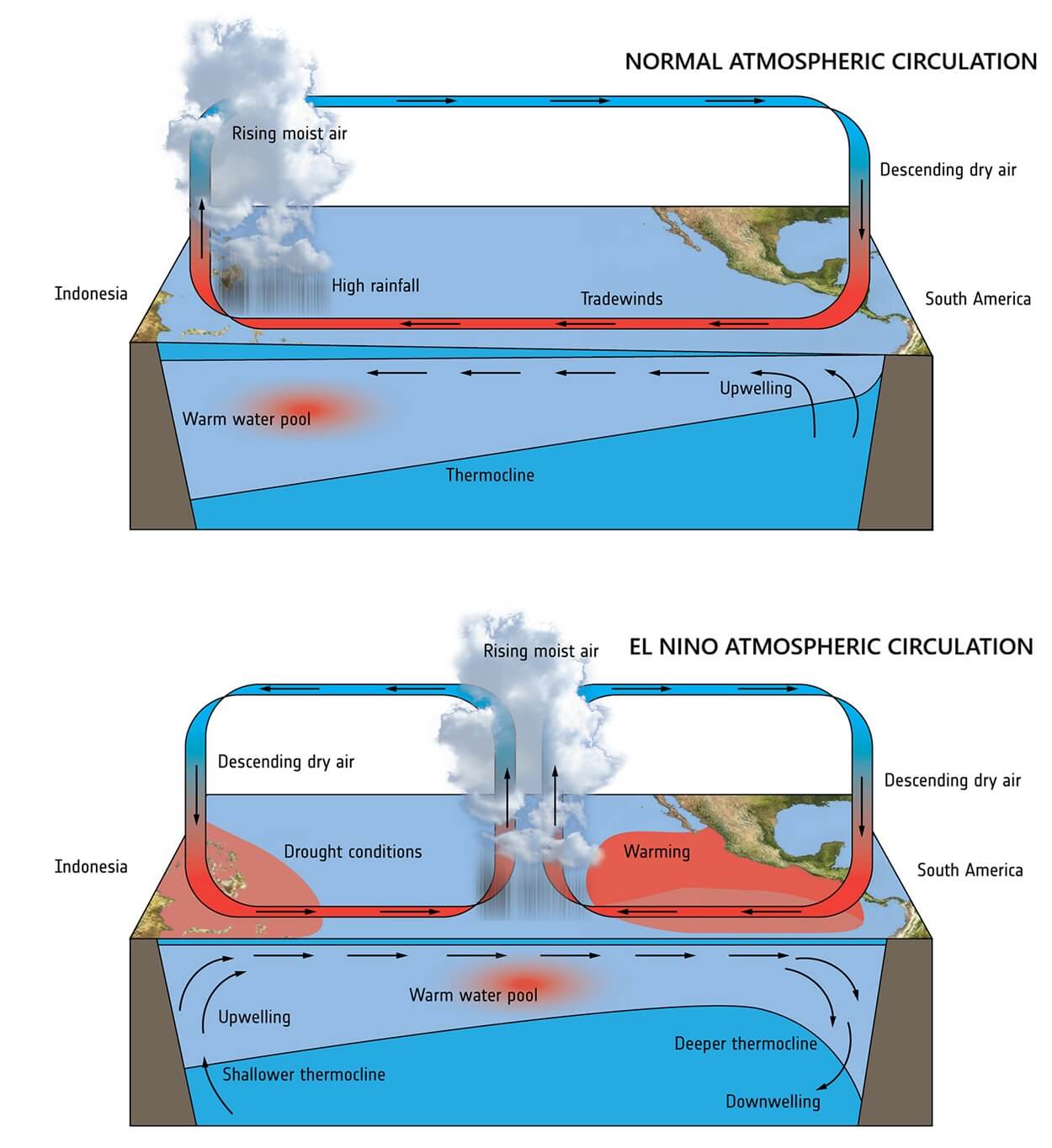
Subsurface ocean temperature analyses down to 800 feet (250 meters) reveal a colossal core of warm water driven eastward by sustained trade wind anomalies. As this subsurface heat travels, it surfaces in the eastern Pacific, ensuring a continuous, self-sustaining thermal supply that insulates the El Niño from atmospheric cooling well into the winter months.
Zonal Wind Anomalies and Trade Wind Collapse
The strength of an El Niño is fundamentally tied to the Walker Circulation—the loop of tropical air moving vertically and horizontally across the Pacific. Normally, strong easterly trade winds push warm water toward Asia. However, the June-July 2026 data proved that these trade winds experienced a historic collapse. Sustained westerly wind bursts forced warm surface waters eastward, creating an extraordinarily robust ocean-atmosphere coupling.
Model Consensus and Forecasting Trends
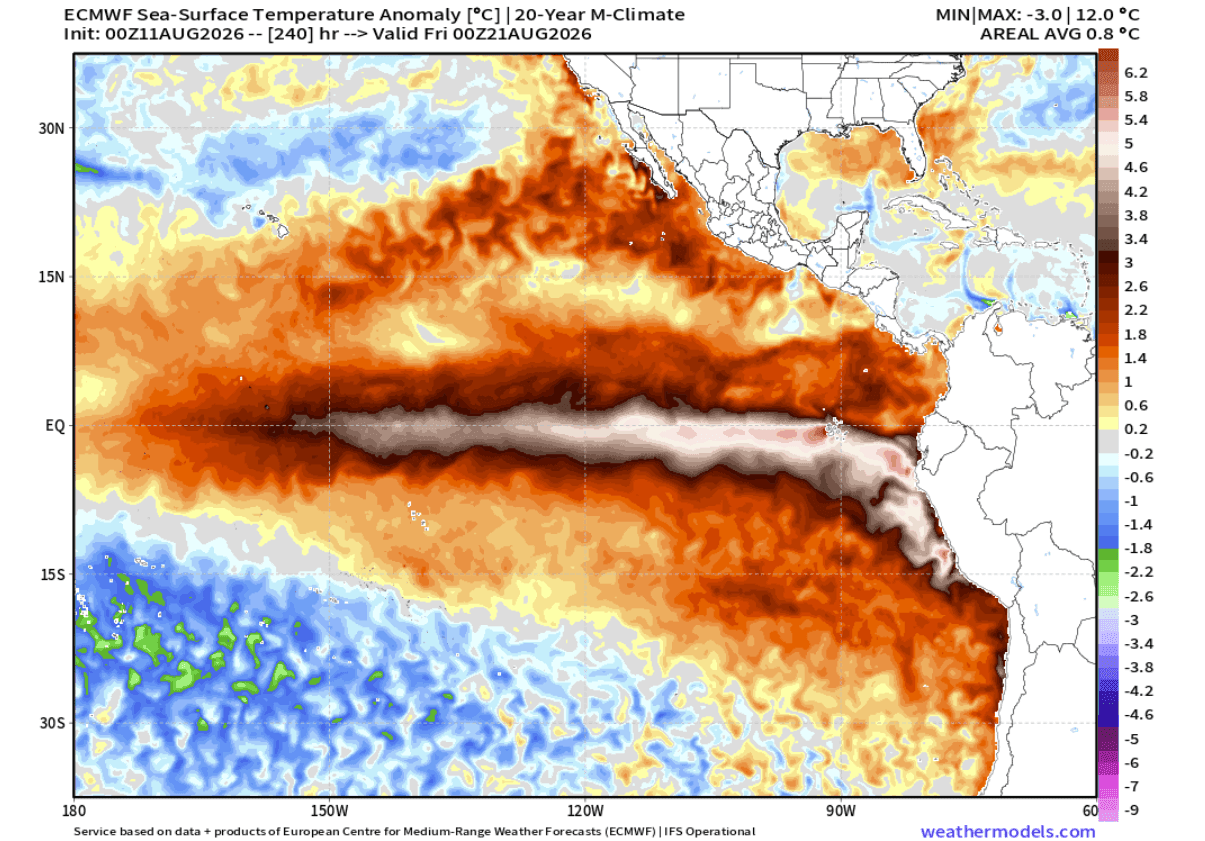
Comparing the last seven ECMWF seasonal runs reveals a striking upward revision trend. Each successive run since February has projected a higher peak anomaly. This persistent upward shift confirms that the atmosphere has locked into a permanent feedback loop, forcing long-range models to continuously upgrade the event into record-breaking territory.
4. Official Responses and Scientific Analysis
Global meteorological agencies, including NOAA, the Australian Bureau of Meteorology (BOM), and ECMWF, are closely monitoring the event as it tracks past the milestones of previous historic benchmarks, including the 2015–2016 and 1997–1998 super events.
Atmospheric scientists point to the Velocity Potential parameter derived from Global Data Assimilation System (GDAS) data to explain the systemic global impact. The data shows broad, intense rising air anomalies (teal hues) locked directly over the central and eastern Pacific, paired with stable sinking air over the Indian Ocean.
When ocean heat reaches this intensity, it overpowers standard, transient weather drivers, locking the global atmosphere into a permanent standing wave. This stationary atmospheric wave guarantees that regional weather anomalies across North America and Europe will not be random, but rather structurally bound to the tropical Pacific heat source for the remainder of the year.
5. Regional Implications: Fall and Winter 2026/2027 Outlook
The downstream effects of a Super El Niño are vast, dictating divergent weather realities across North America and Europe.
United States and Canada: The Battleground of Jet Streams
The winter pressure pattern forecast for December 2026 through February 2027 features a classic, highly amplified El Niño configuration: a deep low-pressure zone in the North Pacific, a massive blocking high-pressure ridge over Canada, and an active southern jet stream.
- Northern Tier & Canada: Expect milder-than-average temperatures and below-normal snowfall. The dominant Canadian high-pressure ridge will successfully deflect frigid polar air masses northward.
- The Southern U.S. and Gulf Coast: An active, moisture-laden southern jet stream will drive persistent storm tracks, resulting in increased rainfall, cloud cover, and cooler-than-average daytime temperatures across Texas, the Gulf Coast, and the Southeast.
- Mid-to-Late Winter Shift (February Outlook): CFSv2 and ECMWF models hint at a dramatic eastward shift of the pressure wave by mid-to-late winter. This configuration could unlock severe cold anomalies and prime the central, eastern, and northeastern United States for major winter storm, ice, and heavy snowfall scenarios as Pacific moisture intersects periodic cold-air drops.
Europe: A Dominant Westerly and Milder Atlantic Flow
While North America experiences sharp meridional (north-south) temperature divides, Europe’s seasonal outlook is heavily influenced by downstream pressure extensions originating in the North Atlantic.
- Temperature and Pressure: The extension of low-pressure anomalies into northwestern and northern Europe creates a steep north-to-south pressure gradient. This fuels a robust westerly and southwesterly flow straight from the Atlantic, favoring a predominantly milder-than-average winter across central, western, and southeastern Europe.
- Precipitation and Snowfall: The persistent Atlantic flow will inject substantial moisture into the continent, driving above-normal precipitation totals. Broad-scale lowland snowfall anomalies remain largely unfavorable, with significant snow accumulations restricted to the far north, northeast, and higher central mountain elevations.
Outlook and Next Steps
As the 2026/2027 Super El Niño approaches its official peak later this year, the scientific community remains on high alert. With oceanic heat content at record levels and atmospheric coupling fully established, the coming months will test historical weather forecasting limits. Meteorologists will continue issuing refined, localized updates as Fall transitions into what promises to be a highly volatile and impactful winter season.
