

Date of Issuance: September 9, 2026
Valid Period: September 9, 2026, 06:00 UTC – September 11, 2026, 06:00 UTC
Issuing Authority: Severe Weather Europe
Lead Forecaster: Marko Korošec
Main Facts
A significant and potentially destructive two-day severe weather outbreak is rapidly organizing across portions of the western and northern Mediterranean, threatening multiple countries from Wednesday through Friday afternoon. The volatile weather system is being driven by a rare collision of extreme atmospheric instability, high marine moisture fueled by an ongoing historic marine heatwave, and a potent southwesterly jet stream.
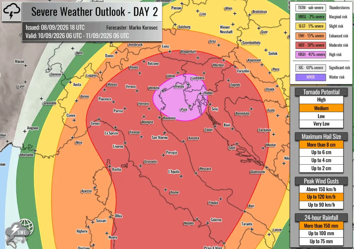
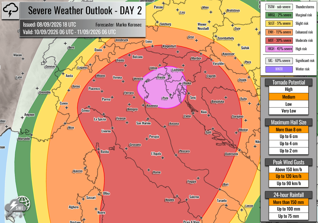
Meteorologists have issued HIGH and Moderate (MDT) risk levels—the upper echelons of severe weather warning thresholds—for extensive regions spanning from the Balearic Islands through southern France, northern and central Italy, Slovenia, Croatia, and the western Balkans.

The primary threats associated with this severe convective outbreak include:
- Destructive Straight-Line Winds: Widespread hurricane-force gusts capable of downing power lines, ripping roofs from structures, and damaging timberlands.
- Giant Hail: Hailstones ranging from 6 to 10 cm (or even larger in isolated supercells), posing a severe threat to vehicles, agriculture, and infrastructure.
- Tornadoes: Enhanced low-level shear and high storm-relative helicity will create favorable conditions for tornadic supercells, particularly along coastal plains and islands.
- Catastrophic Flash Flooding: Torrential rainfall accumulations exceeding 200 mm to 300 mm in localized regions over a 36-hour window, raising severe flash-flood risks following prolonged regional drought.
Chronology of the Outbreak
The severe weather event is unfolding across a meticulously tracked 48-hour timeline, shifting progressively eastward from the Western Mediterranean into the Balkan Peninsula as a sharp cold front races across the continent.
Wednesday, September 9: The Western Mediterranean and Balearic Trigger
The outbreak initiates early Wednesday morning over the Balearic Islands, the Ligurian Bay, and northwestern Italy. An expansive, deep upper-level trough emerging from Western Europe is cutting off over the Northern Mediterranean, creating a severe pressure and temperature gradient against a collapsing blocking high-pressure system to the east.
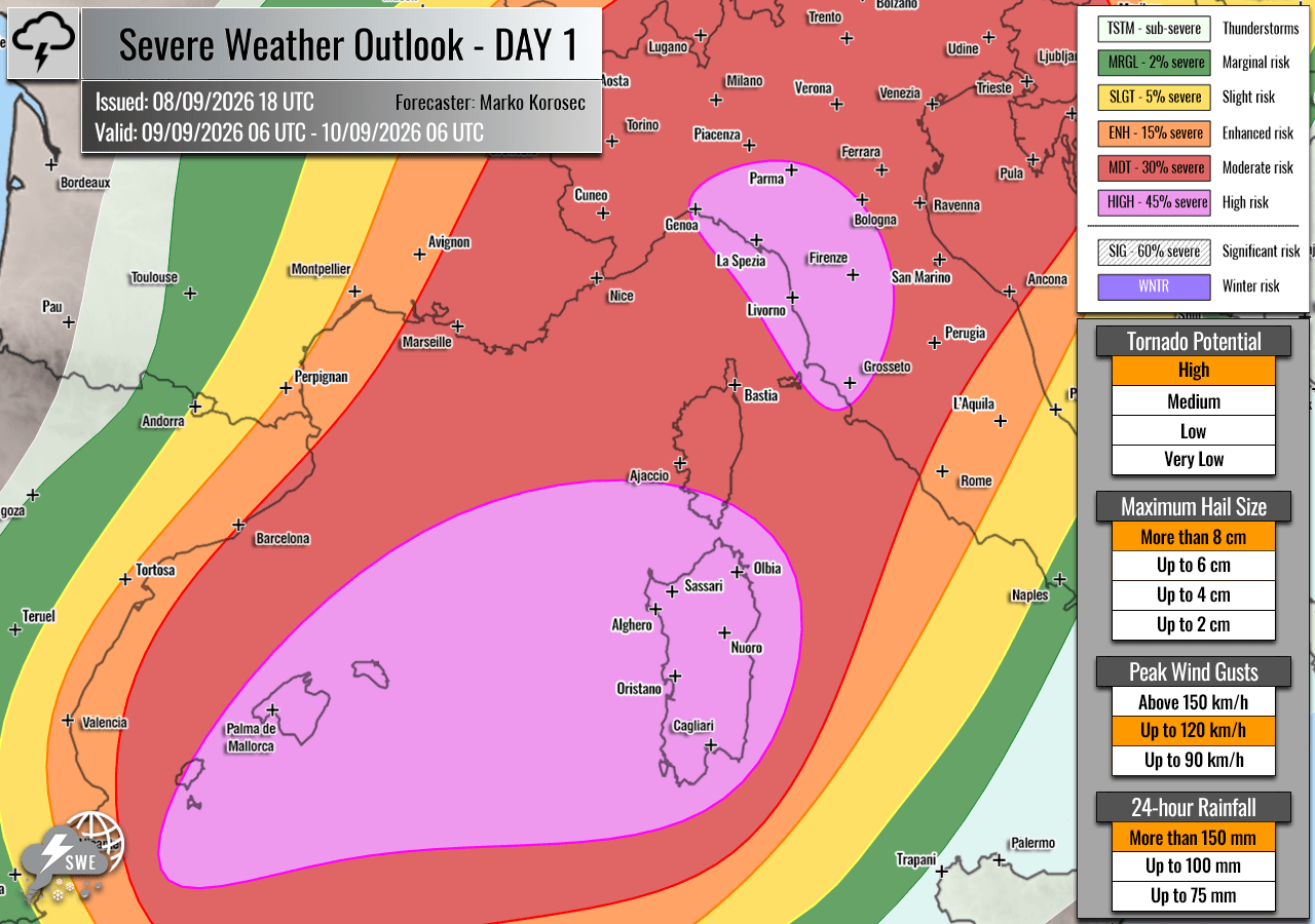
As the morning progresses, strong westerlies aloft are advecting deep moisture from the central Mediterranean into the Balearic landmasses and the Italian coastlines. By midday Wednesday, isolated but intensely violent supercells are forecast to erupt.
- Balearic Islands: Face the maximum immediate threat for tornadic activity due to peak low-level shear and extreme Convective Available Potential Energy (CAPE).
- Ligurian and Tuscan Coasts: Strong southeasterly low-level flow along the western flanks of the Apennines will elevate the risk of rotating updrafts and potential tornadoes.
- Po Valley and Northern Italy: Surface low-pressure development over the northern Italian plains will back winds from the Adriatic Sea, fueling explosive supercells capable of dropping giant hail and destructive winds by Wednesday evening.
- Nighttime Evolution: By Wednesday night, individual storms will begin merging into massive convective clusters, marching northeastward into western Slovenia and northwestern Croatia.
Thursday, September 10 into Friday, September 11: The Balkan and Adriatic Shift
The severe weather axis pivots eastward on Thursday, shifting the primary bullseye to northeastern Italy, the northern Adriatic Sea, western Slovenia, and northwestern Croatia.
- Daytime Thursday: Slow-moving multicells and intense supercells will regenerate across northern Italy and the northern Adriatic, sustained by lingering extreme instability and amplified wind shear.
- Training Storms and Accumulation: The primary danger on Thursday shifts toward persistent, training storm cells—storms repeatedly moving over the same geographic areas—that will exacerbate rainfall totals. Coastal and interior regions could see 36-hour rainfall sums peak at 200–300 mm.
- Friday Transition: Convective activity will gradually push eastward toward the central Adriatic and west-central Balkans before finally weakening by Friday afternoon as the primary upper-level energy dissipates over Eastern Europe.
Supporting Data and Meteorological Dynamics
The severity of this upcoming outbreak is rooted in several interconnected meteorological parameters that are exceptionally rare for mid-September.
Thermodynamic Environment (CAPE and Moisture)
The Mediterranean Sea has been gripped by a historic, prolonged marine heatwave throughout the summer of 2026. This has resulted in unseasonably warm sea-surface temperatures and extremely high dewpoint values—often hovering near or above 25°C—across the western and northern Mediterranean basins.
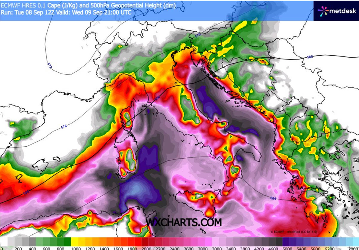
When combined with the cold air advection aloft from the approaching European trough, this high-moisture, high-heat environment will generate extreme atmospheric instability. Mixed-layer CAPE (MLCAPE) values are projected to surge between 3,000 and 4,000+ J/kg. This immense buoyancy acts as high-octane fuel for rising air parcels, allowing updrafts to reach extreme heights and sustain massive cloud structures capable of producing large hail.
Wind Shear and Jet Stream Dynamics
A robust southwesterly jet stream aloft is overspreading the Mediterranean, forced by the sharp height gradients between the deep trough and the eastern ridge. This dynamic provides exceptional deep-layer wind shear.
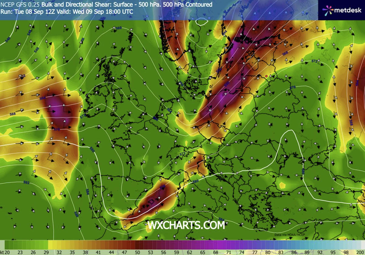
The juxtaposition of strong directional and speed shear with extreme instability creates a classic high-end severe weather setup. The left exit region of the mid-level jet stream will provide persistent large-scale upward vertical motion (forcing), ensuring that storms will not only initiate aggressively but also maintain their structural integrity as they transition from discrete supercells into large linear storm clusters.
Official Responses and Preparedness
In response to the issuance of HIGH risk alerts by Severe Weather Europe and cooperating regional forecasting centers, civil protection agencies and local authorities across Spain, France, Italy, Slovenia, and Croatia have initiated emergency preparations.
- Spain (Balearic Islands): Local maritime and civil emergency services have issued gale warnings and localized flood alerts. Ports have advised recreational vessels to remain docked, and municipal teams are clearing drainage systems to mitigate urban flooding.
- Italy: The Department of Civil Protection has raised weather alert levels to orange and red across Liguria, Tuscany, and parts of northeastern Italy. Citizens have been urged to avoid unnecessary travel during peak storm windows on Wednesday and Thursday, particularly in low-lying areas and near riverbanks prone to flash flooding.
- Slovenia and Croatia: Environmental agencies have warned agricultural sectors regarding the high risk of severe crop damage from giant hail. Flood-prevention barriers are being inspected along major river basins in western Slovenia and northwestern Croatia ahead of the approaching multi-wave rainfall totals.
Implications and Socioeconomic Impact
This impending weather outbreak carries significant socioeconomic implications for Southern and Central Europe.
Agricultural and Infrastructure Vulnerability
The combination of destructive straight-line winds and giant hail (6–10 cm) poses an existential threat to regional agriculture, including vineyards, olive groves, and late-season crop harvests across Italy and the Balkans. Furthermore, infrastructure—ranging from national power grids and transportation networks to residential roofing—will be severely tested by the kinetic energy of these storms.
The Flash Flood Paradox
Large swaths of the target region have suffered from severe, prolonged meteorological drought over the spring and summer months, leaving soils baked, hard, and largely hydrophobic (resistant to water absorption). When compounded with rainfall totals approaching 300 mm in a matter of hours, the earth’s inability to rapidly absorb the moisture guarantees severe, life-threatening flash floods. Urban environments with extensive impervious surfaces will face immediate inundation risks, threatening localized mudslides in mountainous and hilly terrains, particularly along the Apennine and Alpine foothills.
Residents and travelers within the highlighted HIGH and MDT risk zones are strongly advised to monitor local meteorological updates, heed civil defense warnings, and secure all outdoor property before the arrival of the severe weather front.
