

By Global Weather Desk
The Western Pacific basin has spawned an atmospheric monster of historic proportions. Super Typhoon Bavi, a storm that evolved from an unassuming 60-mph tropical disturbance into a colossal, Category 5-equivalent cyclone in less than 48 hours, has placed the entire region on high alert. Boasting sustained winds peaking at an astonishing 180 mph and a central pressure plummeting to 901 mbar, Bavi has firmly cemented its status as one of the most violent, rapidly intensifying tropical systems of the season.

As the storm continues its relentless westward trajectory across the Philippine Sea, meteorologists, emergency management agencies, and government officials across Taiwan, Japan, and mainland China are bracing for a catastrophic combination of destructive winds, towering storm surges, and unprecedented rainfall totals.
Main Facts: Anatomy of a Super Typhoon
The staggering escalation of Super Typhoon Bavi highlights the extreme thermodynamic energy currently trapped within the tropical Western Pacific.
- Explosive Intensification: Bavi transitioned from a modest tropical system into a Category 5-equivalent powerhouse in under 48 hours.
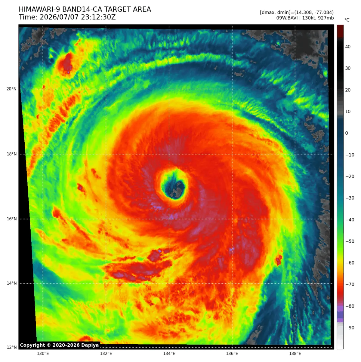
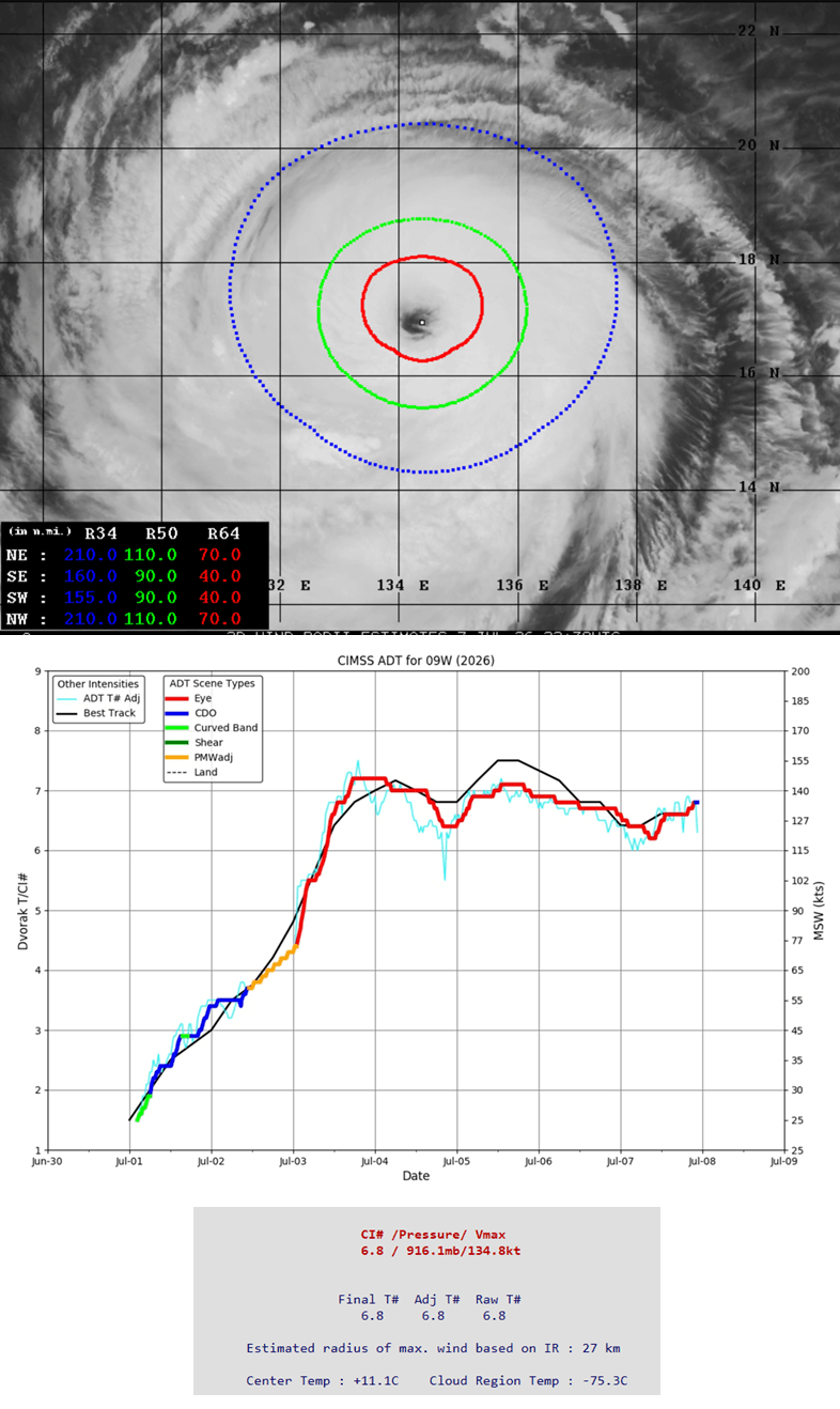
- Peak Intensity: Sustained winds reached a violent 180 mph (approx. 290 km/h), accompanied by a central pressure drop to 901 mbar. Advanced Dvorak automatic satellite analysis estimates current sustained winds near 135 knots (Dvorak intensity of 6.8).
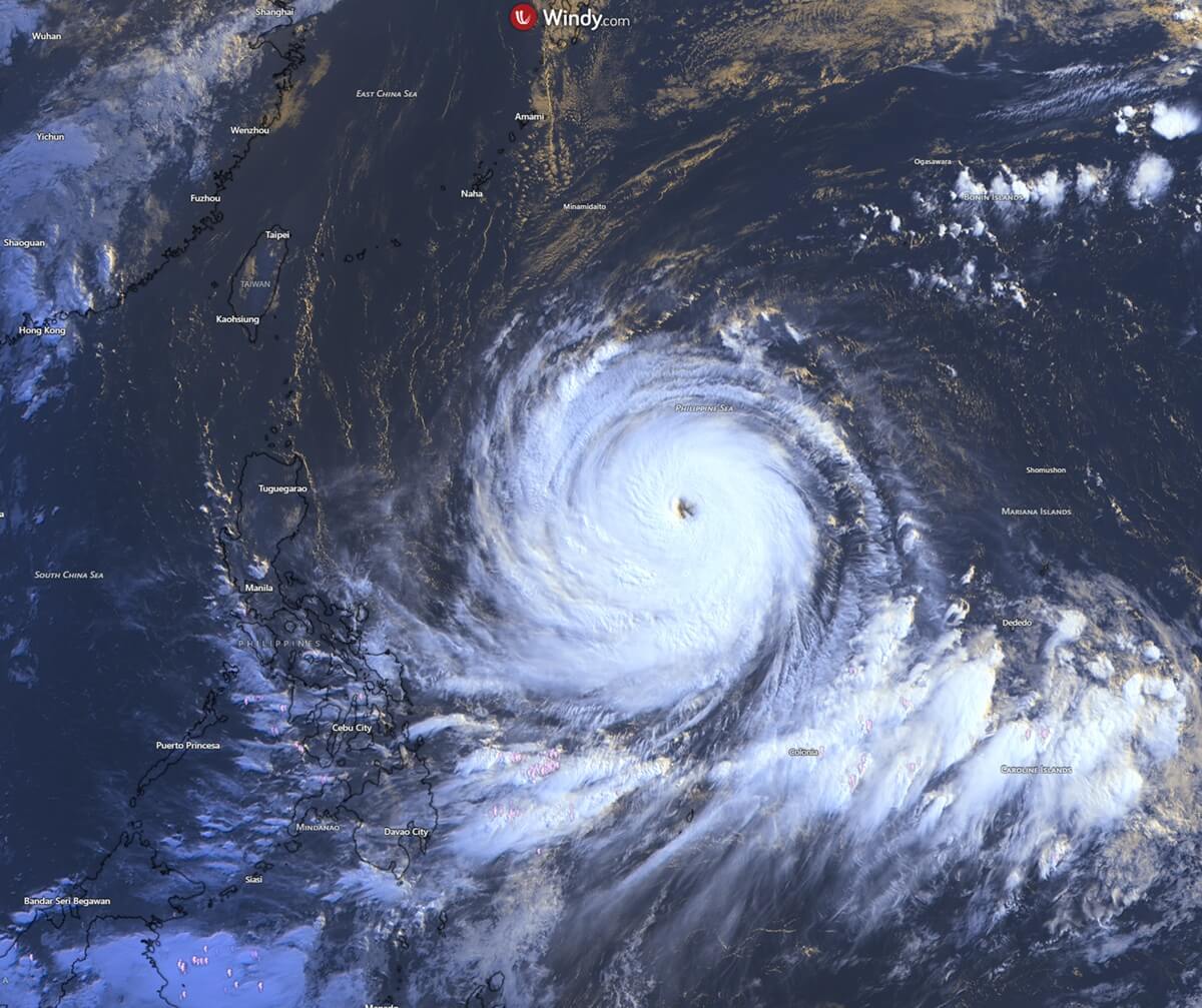
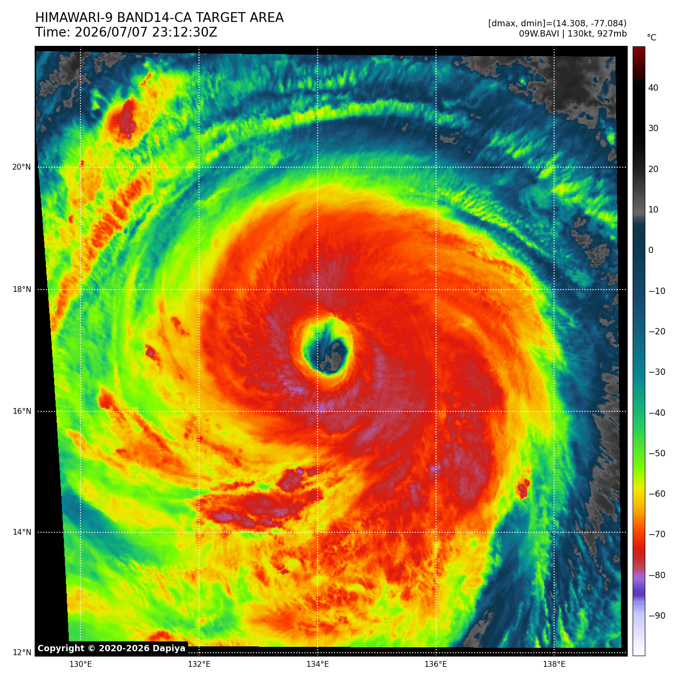
- Vast Wind Field: Hurricane-force winds extend outward 60 to 70 miles from the core in all quadrants, while a broader field of tropical-storm-force winds reaches up to 110 miles from its exceptionally large eye.
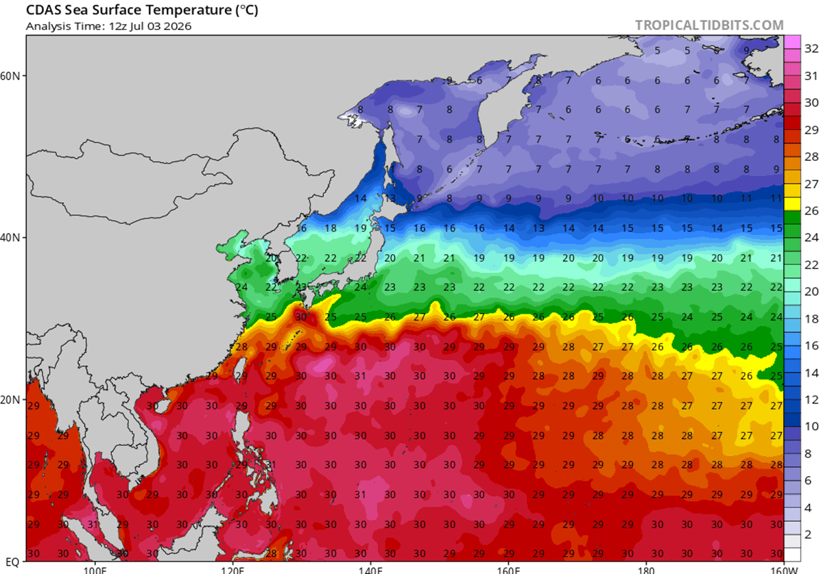
- Fuel Source: The storm feeds on anomalously warm, deep oceanic waters ranging between 29 °C and 32 °C (84 °F to 90 °F)—temperatures running 2 °C to 3 °C above average for early-to-mid July. Coupled with near-zero wind shear, these conditions created near-perfect atmospheric outflow and upper-level ventilation.
Despite undergoing a classic eyewall replacement cycle—a phase where a mature storm’s inner eyewall collapses and is replaced by a wider outer ring—Bavi emerged from the process even more structurally robust and wielding a significantly broader destructive wind field.
Chronology of the Storm: From Genesis to Impending Landfall
Phase 1: Rapid Genesis and the Mariana Islands Impact
Super Typhoon Bavi’s rapid escalation caught regional forecasters off guard as it aggressively tapped into the high-energy waters of the Western Pacific. The true display of the storm’s raw, unfiltered power occurred when its northern eyewall slammed directly over the island of Rota in the Northern Mariana Islands. The impact battered the local landscape with relentless, catastrophic hurricane-force winds and torrential downpours, inflicting severe infrastructural damage.
Neighboring Guam, a territory historically familiar with severe tropical systems, also felt the brunt of Bavi’s outer circulation. The island recorded peak wind gusts reaching 85 mph alongside rainfall accumulations exceeding 20 inches.
Phase 2: The Trek Across the Philippine Sea
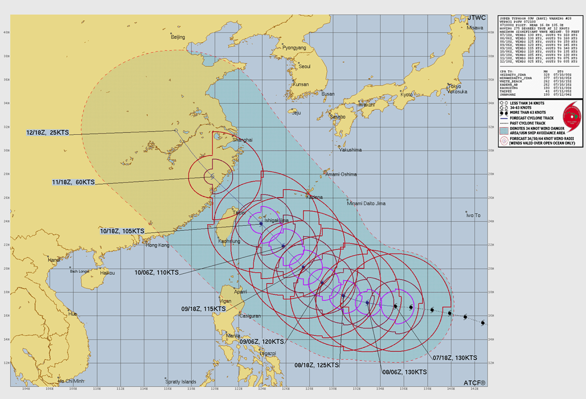
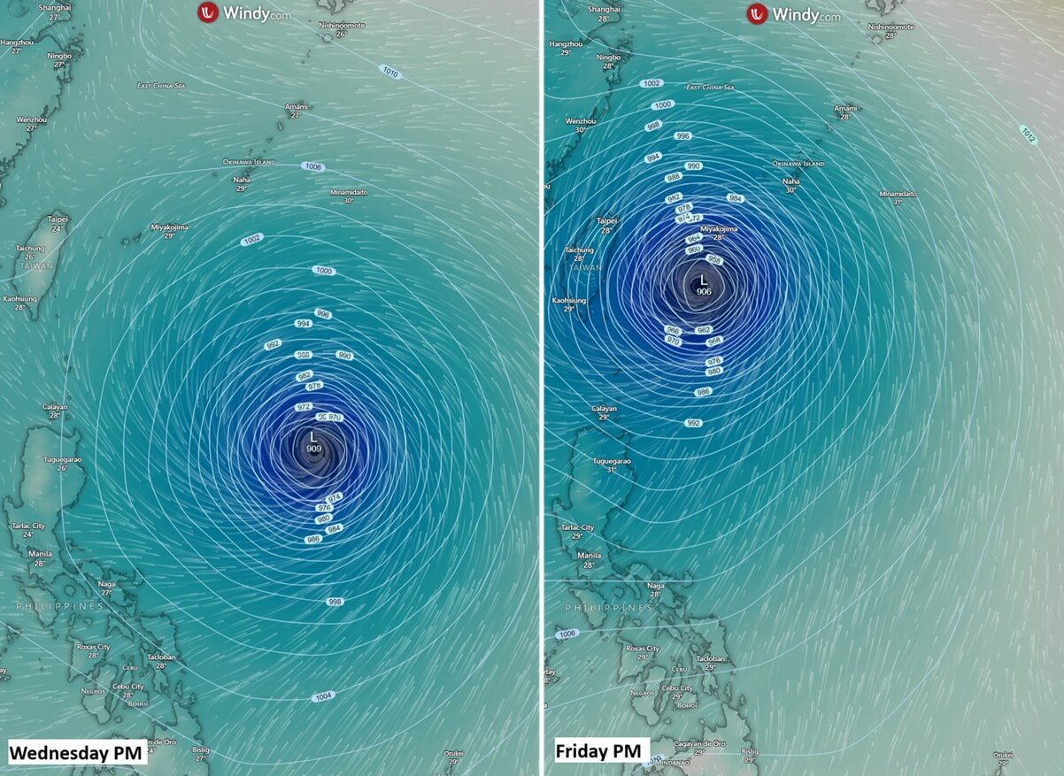
Following its assault on the Marianas, Bavi maintained its violent strength, tracking steadily west-northwestward over the open waters of the Philippine Sea. Satellite imagery revealed an expansive, highly symmetrical cyclone featuring a deeply cold cloud-top canopy and a clearly defined, menacing eye. Weather models indicate that the storm will hover near high-end Category 4 or low-end Category 5 status as it approaches the southern Ryukyu Islands of Japan and northern Taiwan.
Phase 3: Imminent Landfalls in Taiwan and China
By Friday, Bavi’s expansive wind field and outer bands will begin raking Japan’s southern island chain—specifically tourist-heavy destinations like Ishigaki and Miyakojima. While the absolute core of the highest-velocity winds is currently projected to track just north of Taiwan, the island’s northern regions and towering central mountain ranges will face an unprecedented deluge. Bavi is subsequently expected to maintain its storm structure as it bears down on the eastern coast of mainland China by Saturday local time, where it will begin a gradual weakening trend upon interacting with cooler coastal waters and increased land friction.
Supporting Data: Meteorological Drivers and Historical Context
Ocean Heat Content Anomalies
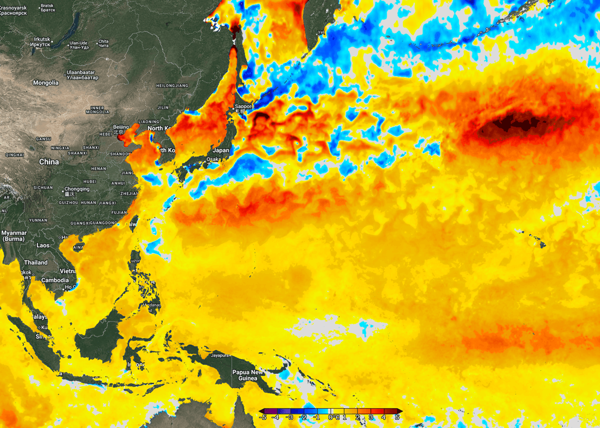
The primary engine driving Bavi’s fury is the unprecedented thermal energy stored in the Western Pacific. Sea surface temperatures (SSTs) across the basin are exceptionally elevated, sitting between 28 °C and 32 °C. More critically, these values represent a significant positive anomaly—waters are 2 °C to 3 °C above the long-term climatological average for this time of year. Further west, toward the coasts of China, Taiwan, and Japan, sea surface temperature anomalies soar up to 4 °C above normal.
These elevated temperatures generate higher dew points and deep near-surface energy. As convective storms ingest this volatile air mass, they fuel explosive thunderstorm development within the eyewall, allowing cyclones like Bavi to defy standard strengthening limits.
Rain Accumulation and Pressure Metrics
Meteorological models consistently point to extreme precipitation as one of Bavi’s most lethal characteristics.
- Open Waters: 300 to 500 mm of rain is forecasted across parts of the Philippine Sea.
- Japanese Islands: Heavy, sustained downpours will inundate the southern Ryukyu Islands on Friday.
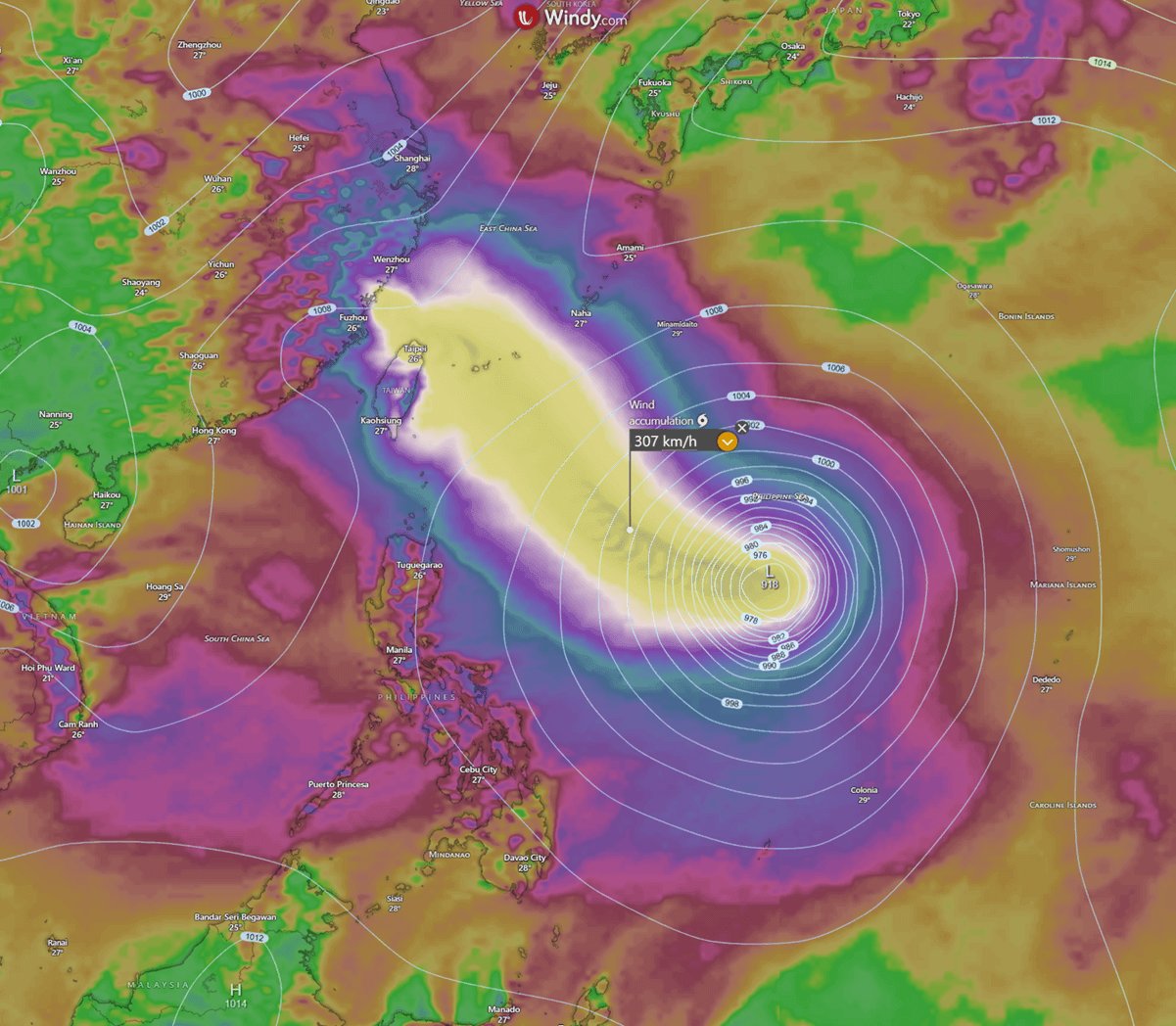
- Taiwan’s Mountainous Terrain: Orographic lift will squeeze monumental amounts of moisture from the storm’s core. Forecasters warn that northern and mountainous regions of Taiwan could record between 600 mm and 1,000 mm (24 to 40 inches) of accumulated rainfall within a compressed 48-hour window, elevating the risk of catastrophic flash flooding and massive mudslides.
Central barometric pressure is projected to hover between 900 and 930 mbar for at least another 36 hours, maintaining a suffocating pressure gradient capable of supporting destructive wind gusts well in excess of 250 km/h (155 mph).
Historical Echoes: Guam and "Typhoon Alley"
Guam and the surrounding Northern Mariana Islands sit directly within "Typhoon Alley," a geographic corridor infamous for generating and channeling some of the most powerful tropical cyclones on Earth. The region’s modern infrastructure is a direct testament to its violent meteorological history.
Prior to 1962, the island was predominantly populated by wooden structures. However, the catastrophic blow dealt by Typhoon Karen in 1962 fundamentally altered building codes, construction methodologies, and urban planning. Today, Guam stands as a fortified "concrete island," built specifically to withstand the brutal parameters of super typhoons like Karen, Paka, Pongsona, and now, Bavi.
Official Responses and Disaster Preparedness
As Super Typhoon Bavi barrels toward populated landmasses, regional governments and disaster response agencies have enacted sweeping emergency protocols.
- Taiwan: Central and local government authorities have issued high-level maritime and land warnings. Emergency response centers have been activated, and military units have been placed on standby for potential deployment to flood-prone areas and remote mountain communities. Pre-emptive evacuations are being strongly encouraged or mandated for residents living in landslide-vulnerable zones across northern and eastern counties. Ports have restricted vessel movements, and major flight carriers are canceling or rescheduling flights in anticipation of severe crosswinds and low visibility.
- Japan: The Japan Meteorological Agency (JMA) has issued severe weather and high-wave alerts for the Ryukyu Island chain, including Okinawa Prefecture. Local municipalities have begun preparing emergency shelters, advising residents to secure outdoor property, stockpile emergency supplies, and stay tuned to real-time meteorological updates. Ferry services and regional aviation connecting the outer islands to the mainland have been suspended.
- Mainland China: Coastal provinces along the eastern seaboard, including Fujian and Zhejiang, are monitoring the storm’s trajectory with heightened vigilance. Maritime authorities have ordered fishing fleets to return to harbor, and coastal engineering projects have initiated secure-down procedures to mitigate potential storm surge impacts ahead of Bavi’s anticipated weekend arrival.
Implications: Infrastructure, Economy, and Climate Realities
The arrival of Super Typhoon Bavi carries profound implications for the socio-economic stability of the Western Pacific rim.
Economic and Supply Chain Disruptions
Taiwan serves as a critical nexus for the global semiconductor and technology manufacturing supply chains. Even if the core winds bypass the island’s major industrial science parks, catastrophic rainfall, prolonged power outages, and logistical halts to shipping ports can create ripple effects across global markets. Furthermore, agricultural sectors in northern Taiwan and the southern Japanese islands face immense vulnerability, with extensive crop damage anticipated from sustained flooding and high winds.
Infrastructure Resilience
Bavi will test the structural integrity of modern engineering standards across East Asia. While metropolises and coastal defenses are engineered to withstand significant wind loads, the sheer volume of rainfall projected—up to a meter of water in localized mountainous areas—threatens to overwhelm urban drainage systems and trigger slope failures in saturated terrains.
The Broader Climate Context
The rapid intensification of Bavi from a minor tropical depression into a top-tier Category 5 monster in less than 48 hours is drawing intense scrutiny from the global climatological community. Storms exhibiting explosive intensification are becoming increasingly frequent in a warming world, fueled by persistently elevated ocean heat content and anomalous sea surface temperatures. Bavi serves as a stark reminder of the escalating risks posed by extreme weather events, underscoring the urgent need for enhanced early-warning systems, climate-resilient infrastructure, and robust international disaster response frameworks across the Asia-Pacific region.
