

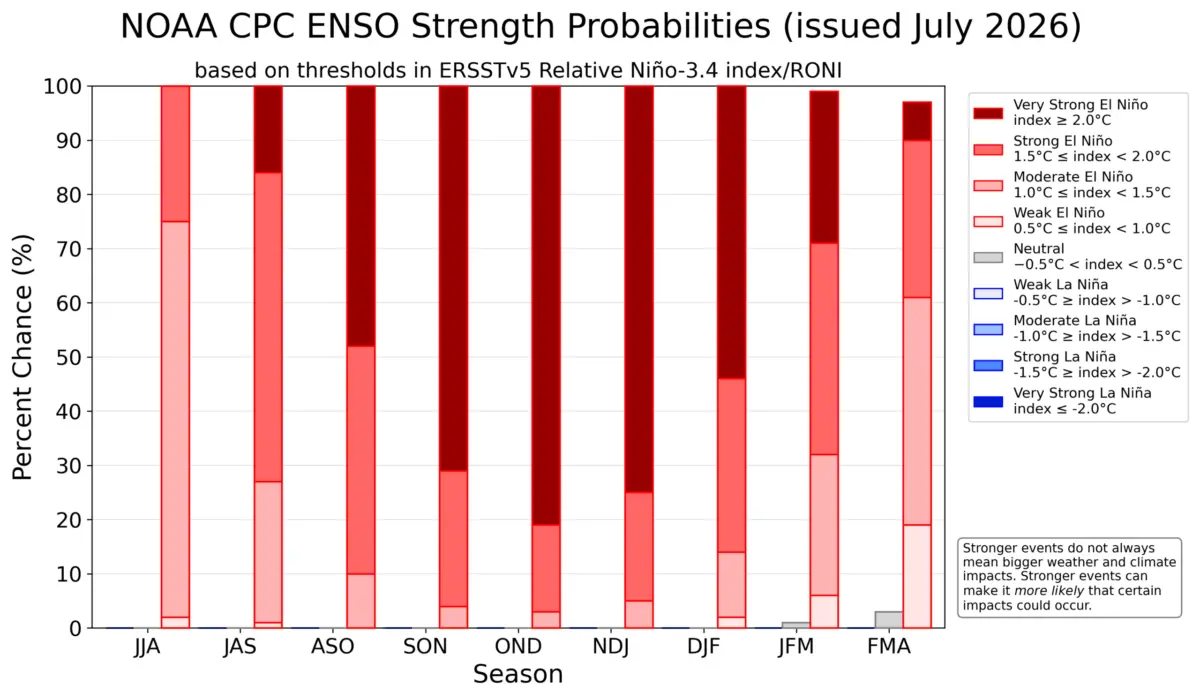
GLOBAL CLIMATE OBSERVATION — A powerful and rapidly intensifying Super El Niño is taking shape across the tropical Pacific Ocean, triggering profound atmospheric shifts that are rewriting long-range weather forecasts for late 2026 and early 2027. According to comprehensive ocean analysis and global forecast models from leading meteorological centers, this emerging climate event is tracking toward potential record intensity.
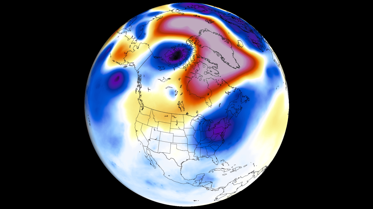
Atmospheric scientists and climatologists are closely monitoring the event, which has already established a robust global circulation response. With warm subsurface water anomalies surging eastward and the atmospheric jet stream beginning to buckle, the Northern Hemisphere faces a high-impact transitional period from summer into an aggressive fall and winter season.
Main Facts: The Anatomy of a Developing Super El Niño
The 2026/2027 El Niño is no ordinary climate fluctuation. Driven by massive sea-surface temperature anomalies and sustained westerly wind bursts in the equatorial Pacific, the event is pushing well past standard operational thresholds.
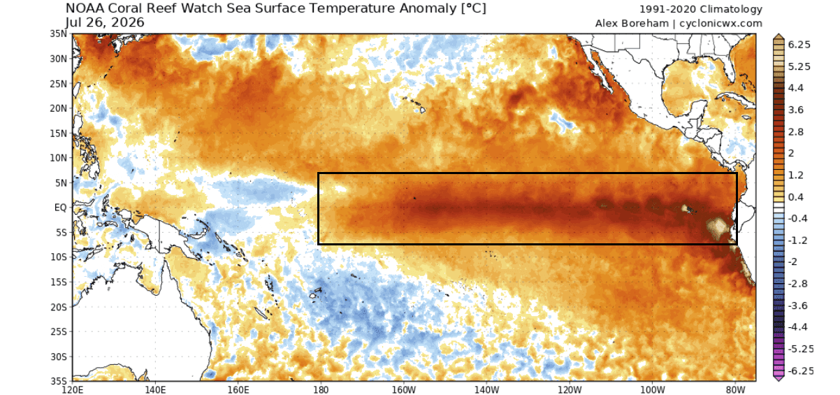
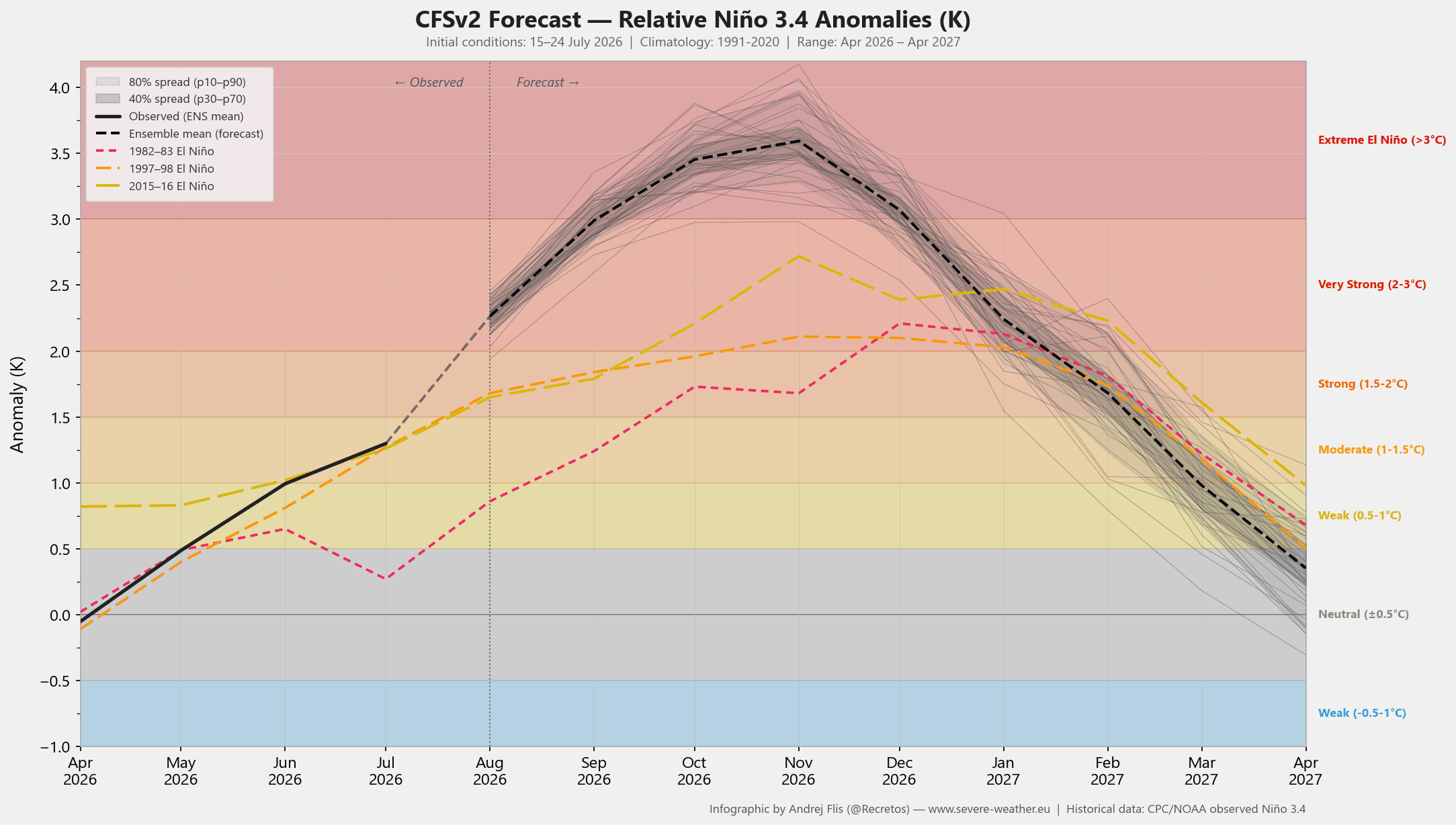
- Extreme Temperature Anomalies: Latest ocean data reveals warm anomalies exceeding +5°C above normal in key equatorial Pacific regions. Forecast models, including the NCEP CFSv2, project peak ENSO index values to clear the +3°C mark—deep into "Super El Niño" territory.
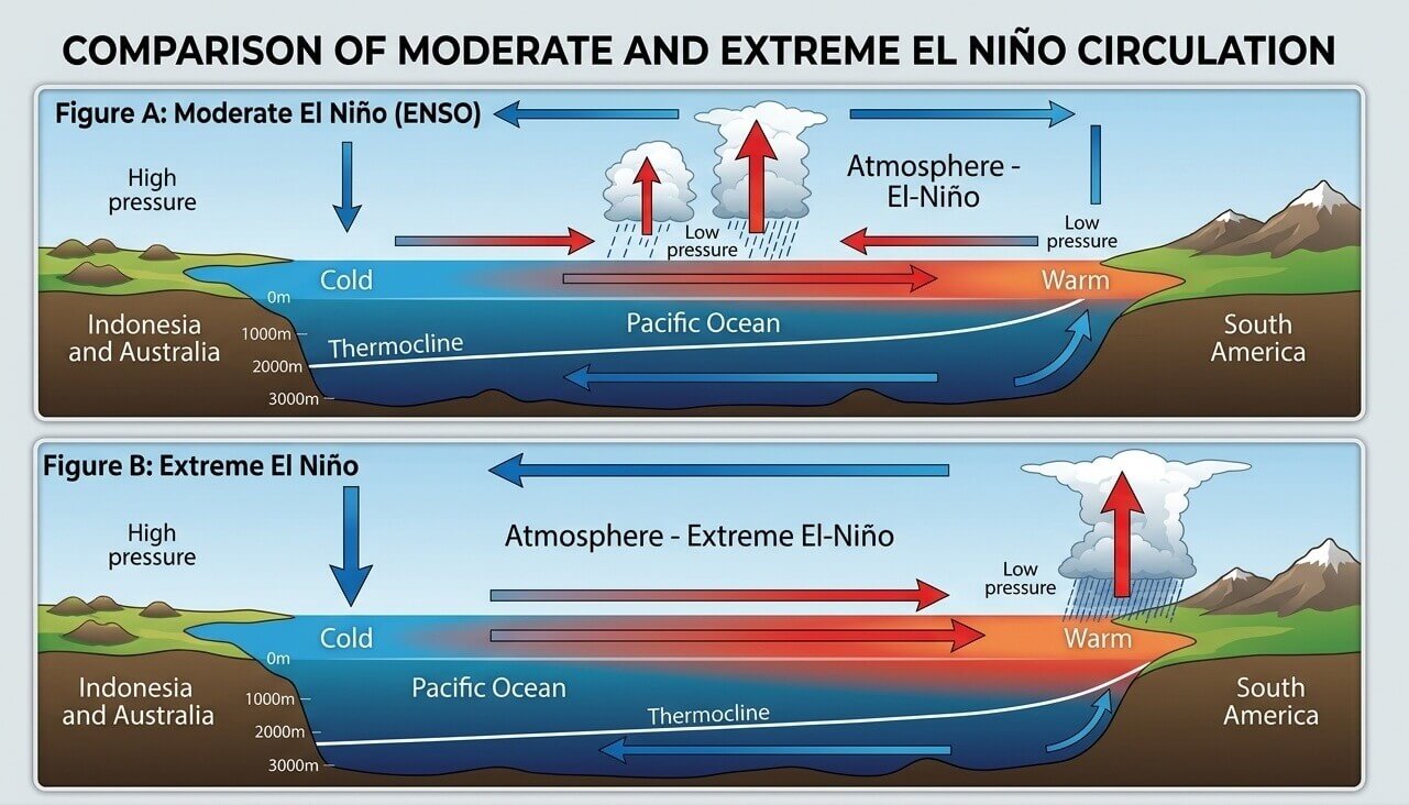
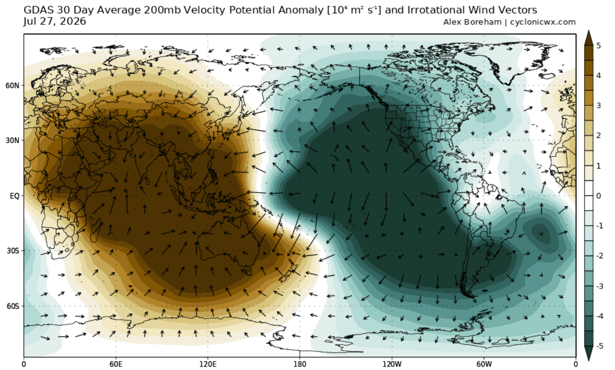
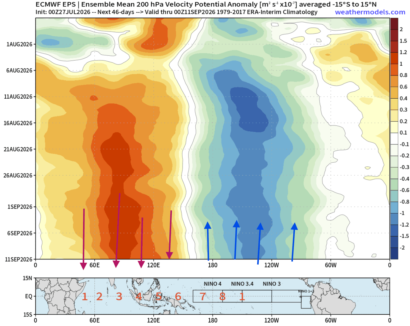
- The Atmospheric Bridge: The phenomenon is fundamentally altering the Walker Circulation—the massive loop of tropical air motion. Strong rising air over the central and eastern Pacific is being counterbalanced by intense sinking motion over the Indian Ocean, locking a permanent standing wave into the global atmosphere.
- Kelvin Wave Forcing: Unusually strong westerly wind bursts deep in the ocean have generated a massive subsurface warm anomaly known as a Kelvin Wave. This thermal wave has risen to the surface, cementing the current El Niño trajectory.
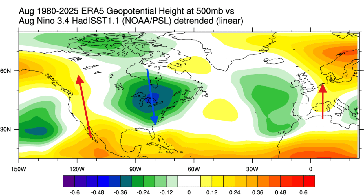
- Geographic Impact Zones: North America is experiencing the earliest direct atmospheric feedback, while Europe is tracking a delayed, highly nuanced response shaped by secondary meteorological factors.
Chronology of Development: From July Signals to Winter Extremes
Understanding how this extreme climate driver will impact everyday weather requires tracking its chronological evolution from summer groundwork to mid-winter peaks.
July 2026: The Initial Atmospheric Footprint
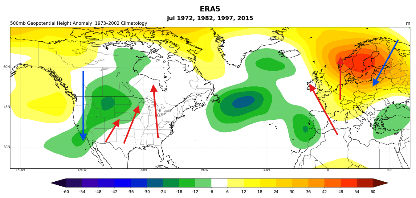
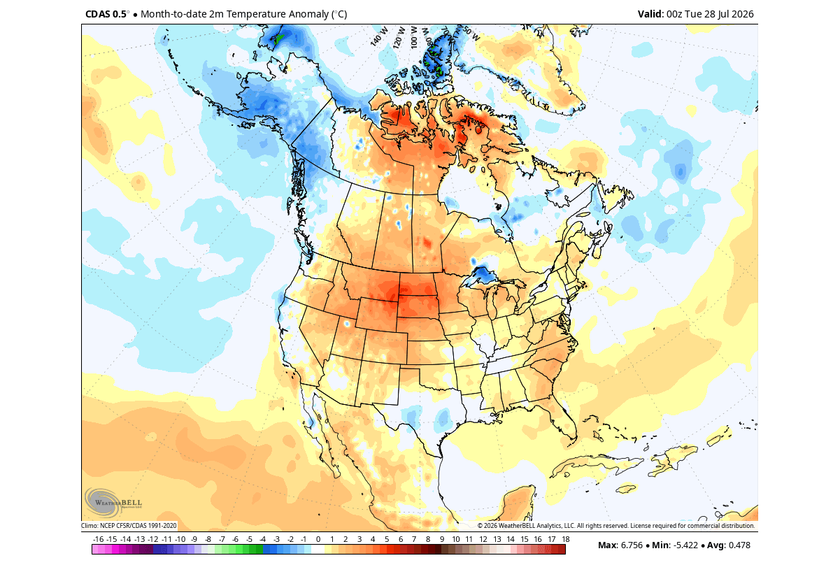
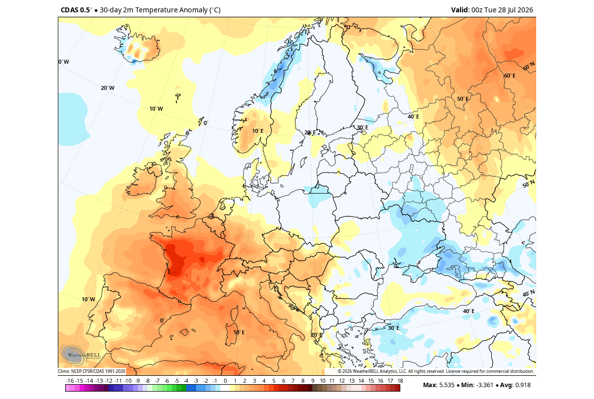
As July draws to a close, observed pressure and temperature anomalies across North America mirror historical benchmarks set during previous Super El Niño events. A displaced low-pressure zone over the west-central United States has allowed warm southerly airflow to dominate the central and eastern U.S. and Canada, while a cooler northwesterly flow grips the West Coast. Over Europe, early signals show a dominant high-pressure blocking anomaly over the north, fostering warmth in the west.
August 2026: Locking Down the Standing Wave
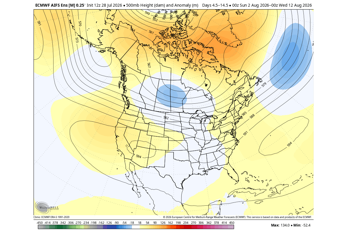
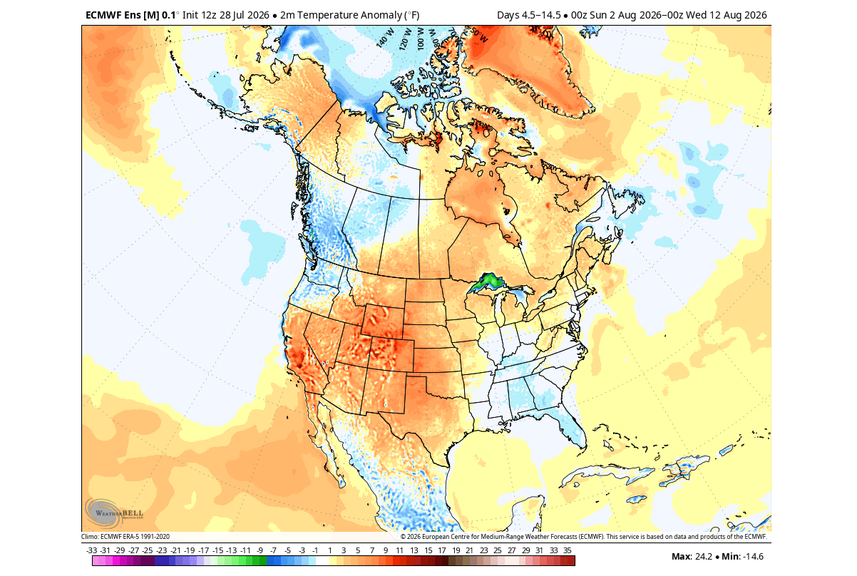
Entering August, the ECMWF ensemble forecasts confirm that the tropical Pacific standing wave is solidifying. An atmospheric stationary wave is anchoring low pressure over the central and eastern Pacific, exerting immense control over mid-latitude jet streams. While early August displays some localized variances—such as a brief cooler pocket over the eastern U.S.—mid-to-late August modeling indicates a sharp pivot. A distinct troughing shift is locking into the eastern United States and Canada, driven by an invigorating subtropical jet stream.
Fall 2026: Amplified Jet Stream and Storm Tracks
By autumn, the El Niño "signature" becomes unmistakably clear in daily weather patterns. Driven by an accelerated Pacific jet stream, the southern half of the United States faces an active, moisture-laden storm track, increasing rainfall totals across the Gulf Coast and southern tiers. Meanwhile, high pressure builds over northern North America, maintaining milder conditions across the north. In Europe, a prevailing westerly and southwesterly flow from Atlantic low-pressure systems brings above-average autumn rainfall and warm surface anomalies to central and western regions.
Winter 2026/2027: Split-Flow Regime and Cold Air Intrusions
The ultimate culmination of the Super El Niño arrives in winter. Seasonal forecasts project a classic, highly amplified split-flow atmospheric pattern across North America. High pressure anchored over Canada will act as a shield, suppressing deep, persistent Arctic air masses and reducing traditional snowfall potential across the Northern Plains, Upper Midwest, and Great Lakes.
Conversely, the active southern storm track will shift winter weather opportunities directly into the Central and Southern Plains, as well as the interior Mid-Atlantic. Surface temperature outlooks for January and February 2026/2027 highlight a progressive cooling footprint across the southern tier of the U.S., deepening significantly by mid-winter as frequent cold air intrusions take hold.
Supporting Data and Modeling Insights
Meteorological insights rely on multi-model ensembles, reanalysis data, and historical analogs. The current forecast framework is built upon several critical analytical pillars:
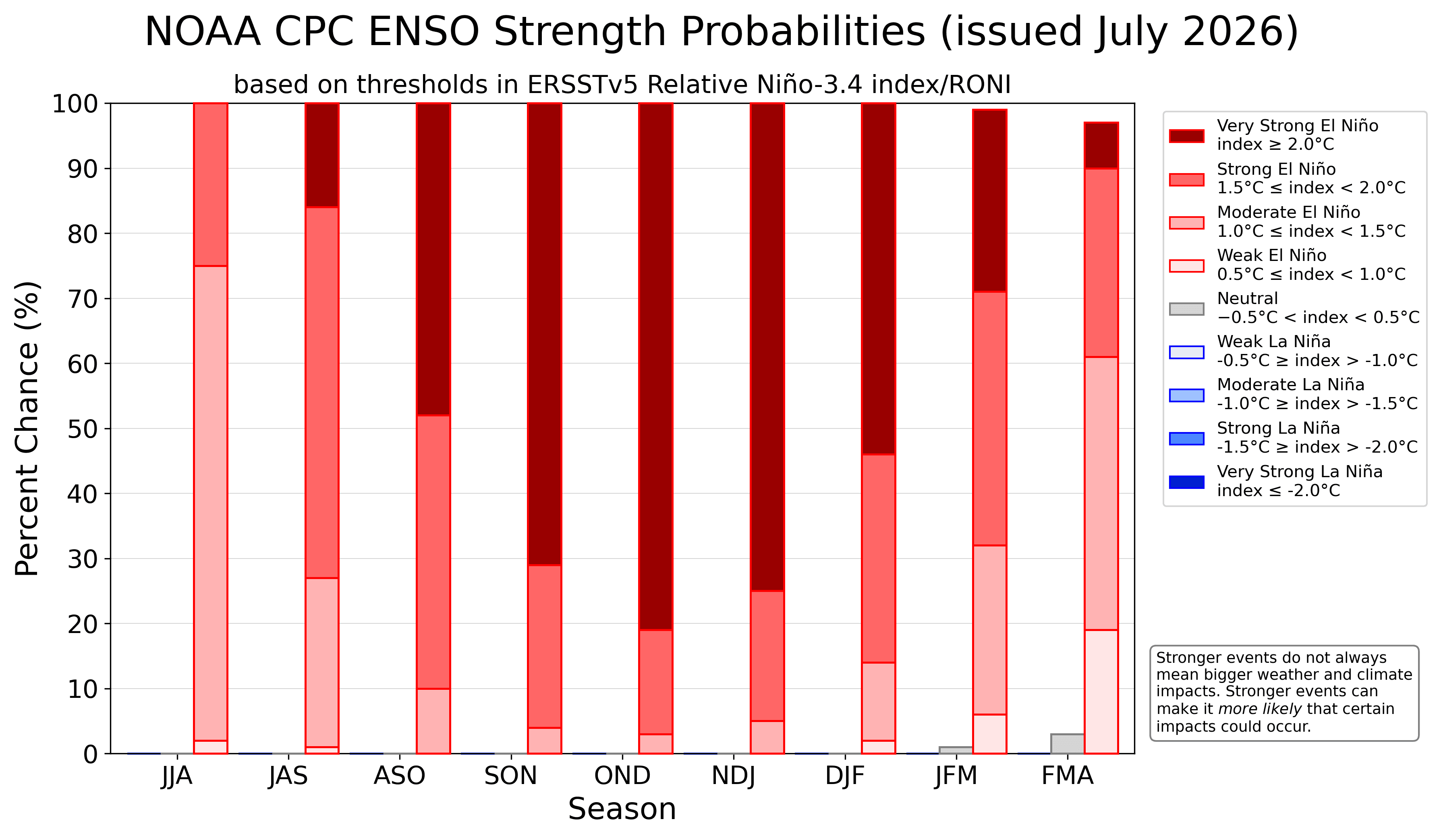
- NOAA CPC and NCEP CFSv2 Projections: Probability outlooks from the Climate Prediction Center show overwhelming ensemble support for an extreme El Niño peak stretching through late fall and early winter. The trajectory is notably steeper than previous benchmark events.
- ECMWF Reanalysis and Velocity Potential: GDAS and ECMWF data analyzing velocity potential at the 200mb level (approximately 12 kilometers high) clearly map the altered global circulation. Teal-colored anomalies signify intense upper-level divergence (rising air) over the Pacific, perfectly matching classic El Niño paradigms.
- Eastern Pacific (EP) vs. Central Pacific (CP) Dynamics: Seasonal NMME forecasts classify the 2026 event primarily as an Eastern Pacific (EP) occurrence with peak anomalies clearing +4°C. While EP events historically interact differently with upper-level winds compared to Central Pacific events, the raw magnitude of this specific Super El Niño overrides typical structural variances, driving severe winter anomalies regardless.
Official Responses and Institutional Outlooks
Major meteorological agencies, including the National Oceanic and Atmospheric Administration (NOAA), the European Centre for Medium-Range Weather Forecasts (ECMWF), and various academic climate research groups, are issuing heightened advisories.
Governments, agricultural planners, and emergency management services in North America and Europe are utilizing these long-range predictions to prepare infrastructure for weather extremes. In agricultural sectors, the anticipated shift toward a wetter southern U.S. storm track combined with dry spells in the Pacific Northwest requires preemptive water resource management. Similarly, municipal authorities in Europe and North America are reviewing seasonal snow removal, flood mitigation, and energy grid load forecasts to offset disruptions tied to the shifting jet stream.
Global Implications: What This Means for Agriculture, Energy, and Society
The cascading effects of a Super El Niño of this magnitude extend far beyond localized temperature shifts. The economic and societal implications are profound:
- Energy Markets: A milder winter across the northern tier of North America may reduce peak heating demand in traditional cold-weather strongholds, while increased cooling and heating volatility in the southern U.S. could stress regional energy grids.
- Agricultural Sectors: The projected precipitation anomalies—featuring dry conditions in the Pacific Northwest, upper Midwest, and parts of Canada, contrasted with heavy rainfall across the southern U.S.—will directly impact crop yields, planting schedules, and livestock management.
- Global Weather Extremes: Historically, Super El Niños restructure global climate baselines. While North America and Europe experience direct jet stream steering, teleconnections frequently induce drought conditions in parts of Southeast Asia and Australia while intensifying rainfall in South America.
As the atmosphere continues to respond to the massive thermal engine operating in the Pacific, meteorological agencies will update long-range models weekly. Stakeholders across the Northern Hemisphere are advised to monitor ongoing updates as the 2026/2027 Super El Niño accelerates toward its winter peak.
