

Main Facts: The Convergence of Extreme Tropical Anomalies
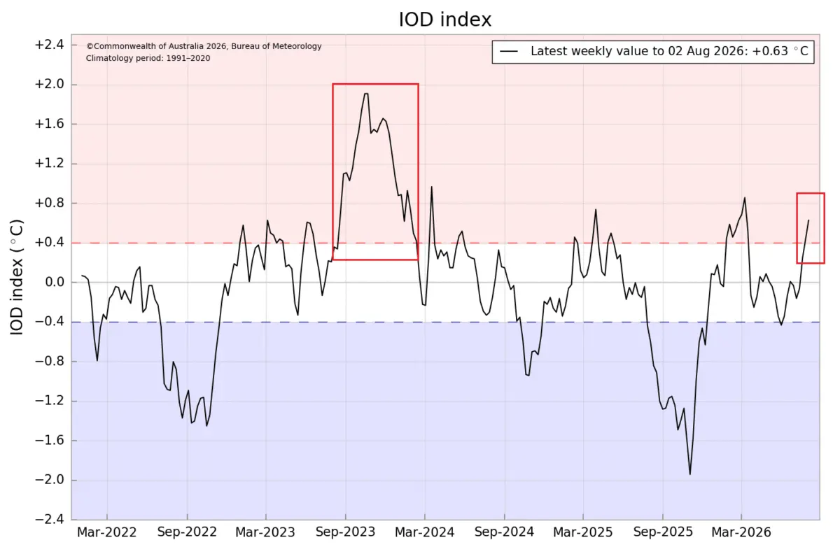
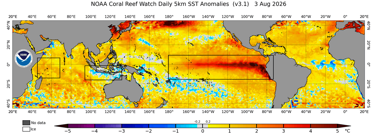
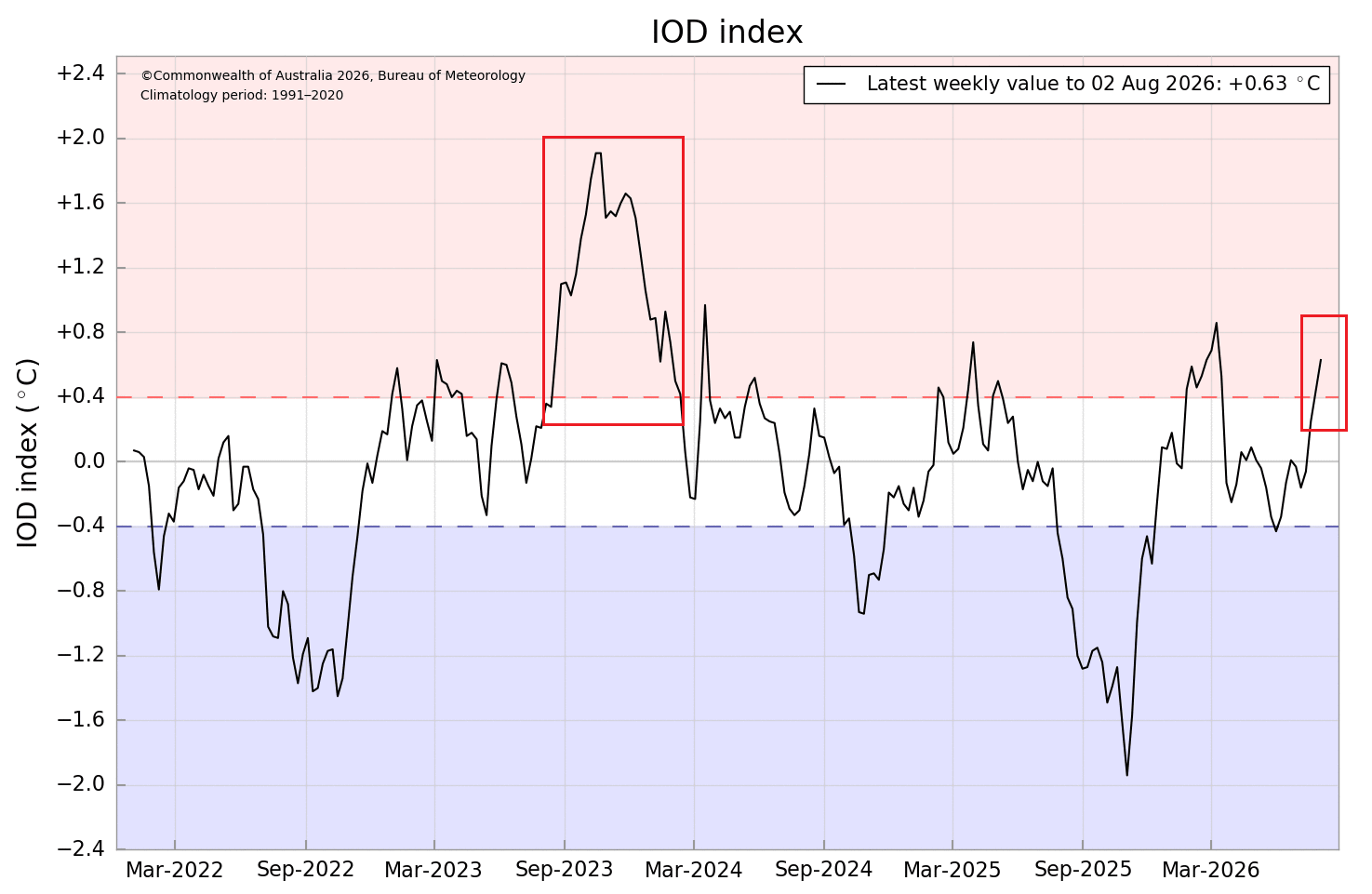
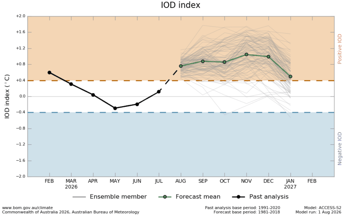
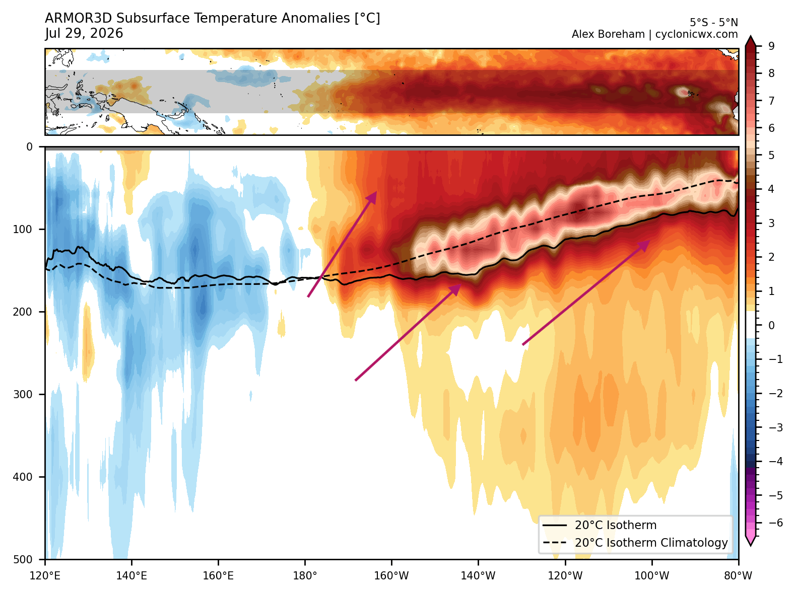
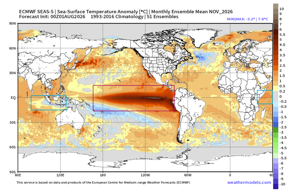
As the Earth transitions into the second half of the year, meteorologists and long-range climate forecasters are tracking an unprecedented alignment in the global tropics. A rapidly strengthening Super El Niño is currently unfolding across the equatorial Pacific Ocean, boasting subsurface ocean temperature anomalies reaching an astonishing 8 degrees Celsius above normal. Simultaneously, a robust positive phase of the Indian Ocean Dipole (IOD) has emerged, setting the stage for a synchronized dual-ocean climate engine.

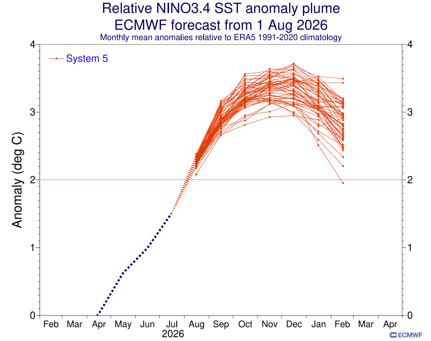
Seasonal climate models, including those from the European Centre for Medium-Range Weather Forecasts (ECMWF) and the National Centers for Environmental Prediction (NCEP), indicate that these coupled oceanic and atmospheric anomalies will persist through the upcoming autumn and into the core of the Winter 2026/2027 season.
This dual-ocean forcing is not merely a localized event; it serves as a master conductor for the global atmospheric circulation. By altering large-scale convection, pressure gradients, and trade wind dynamics, the combined force of the Super El Niño and the positive IOD will dictate the behavior of the Northern Hemisphere jet stream. Consequently, long-range forecasters are issuing preliminary outlooks detailing distinct temperature splits, active storm tracks, and varied snowfall trends across the United States, Canada, and Europe.
Chronology: From Summer Anomalies to Winter Impacts
The development of the Winter 2026/2027 weather regime follows a precise chronological progression, beginning in the tropical ocean basins and cascading poleward via atmospheric wave trains.
Early Summer: Subsurface Awakening and Trade Wind Shifts
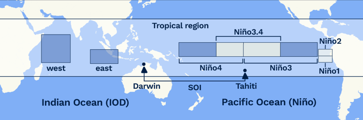
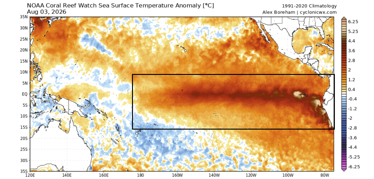
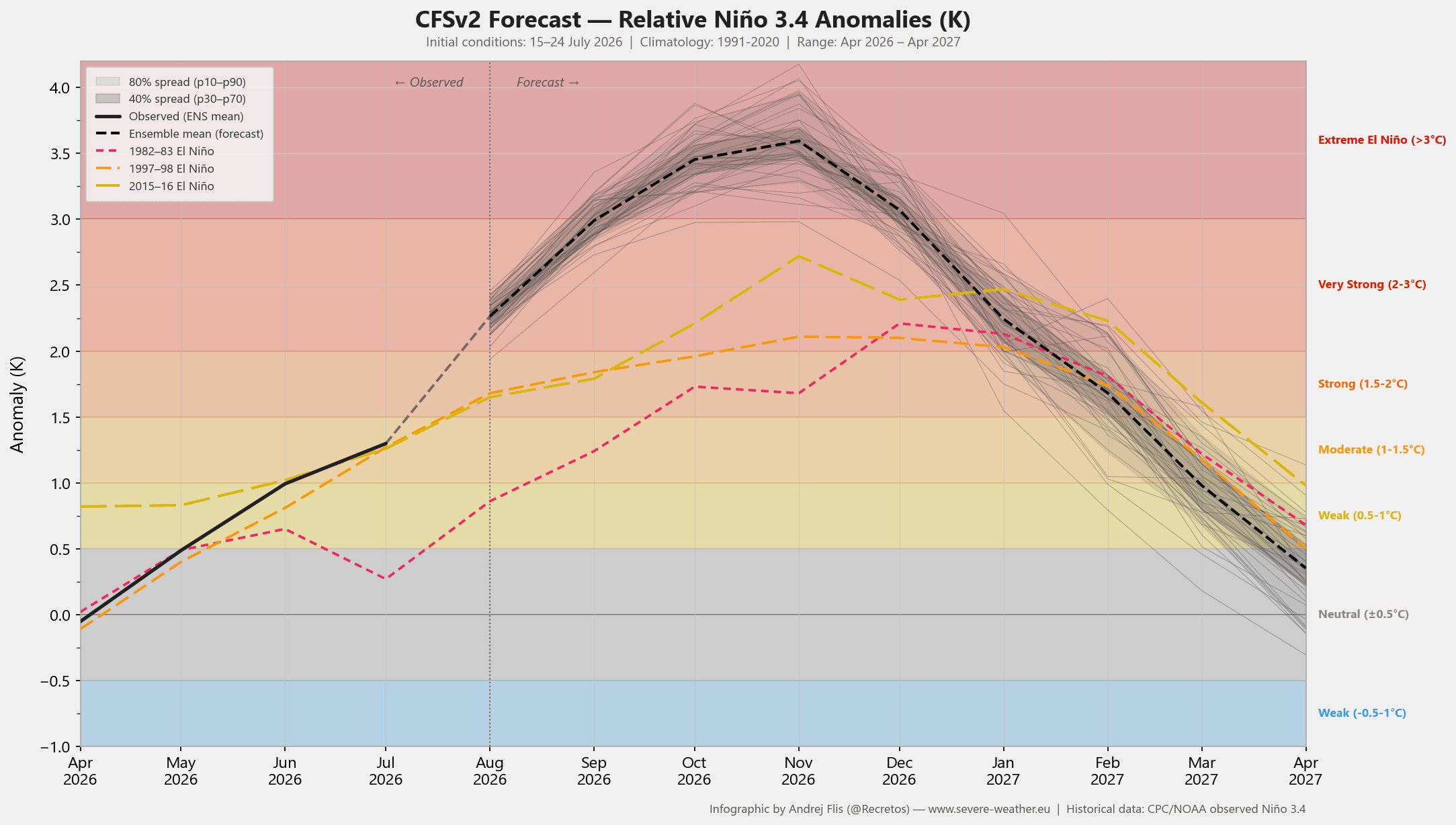
The foundation for the current climate setup was laid months prior, but accelerated significantly in early summer. Weakening trade winds across the tropical Pacific allowed massive volumes of warm subsurface water—manifesting as a powerful Kelvin wave—to surge eastward. By August, surface anomalies in the central and eastern ENSO regions had already surged past +4°C, signaling the aggressive onset of a historic Super El Niño.
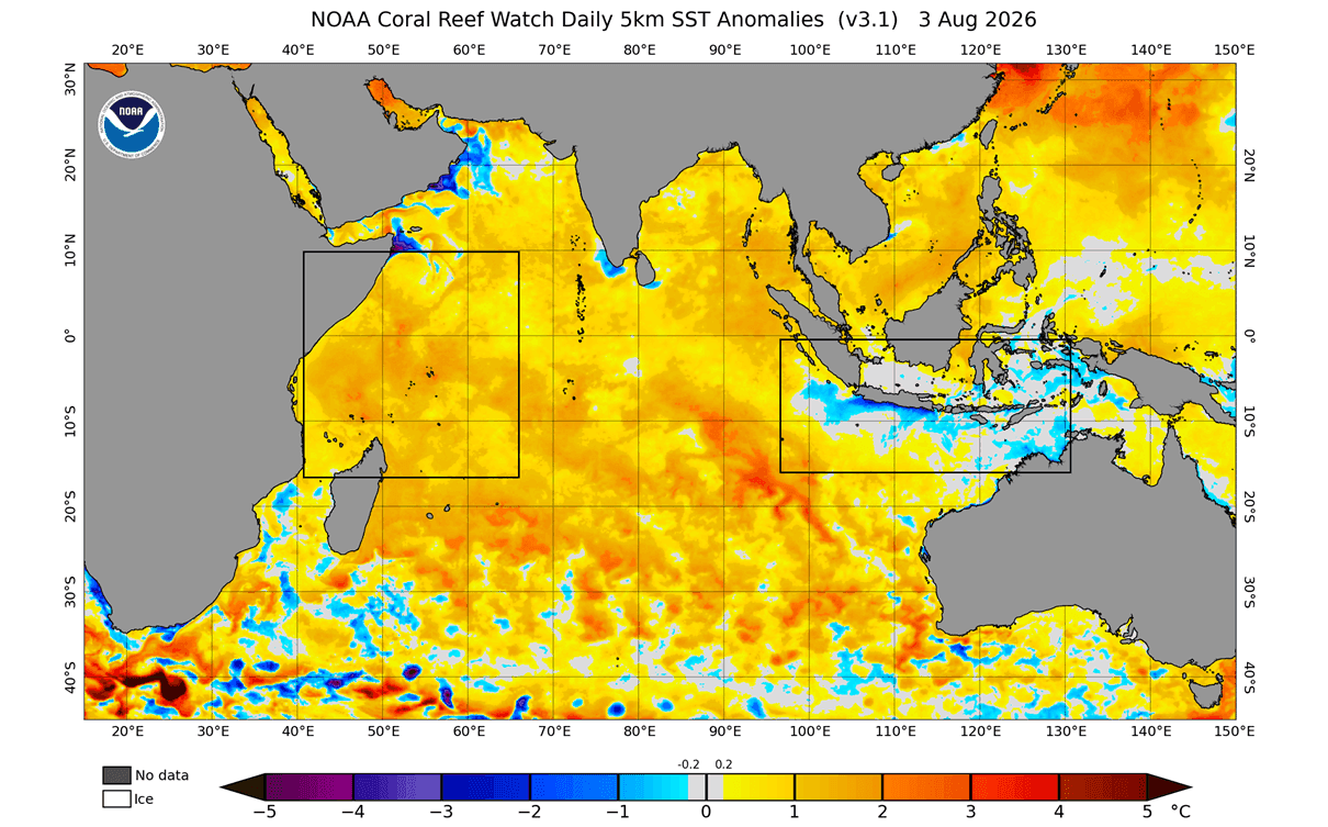
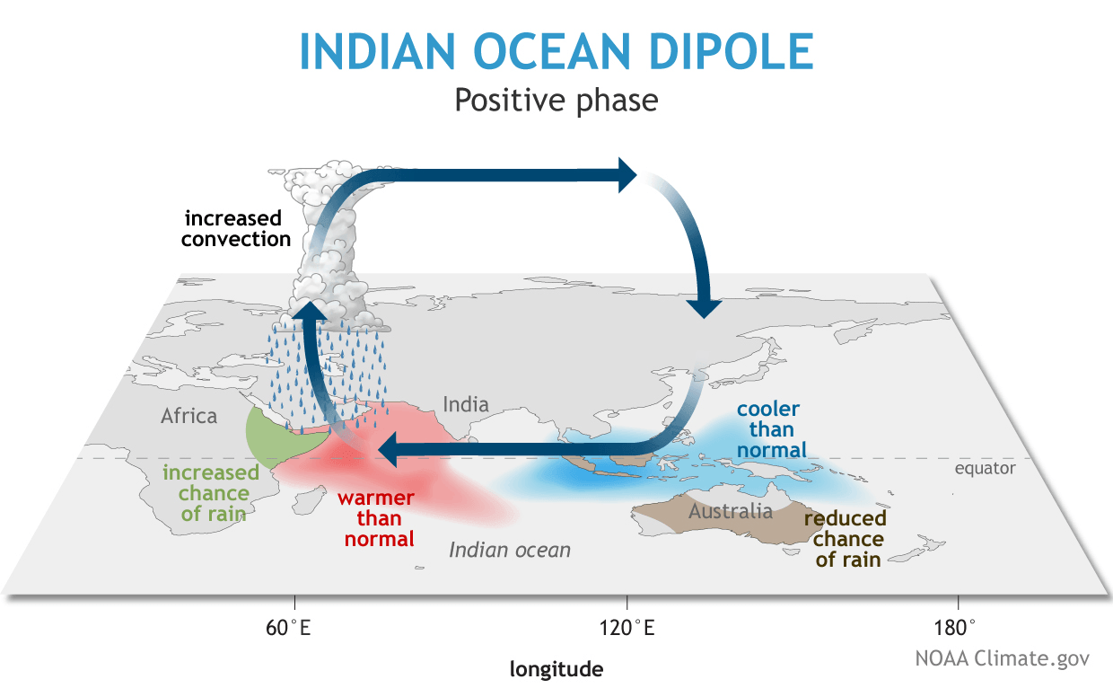
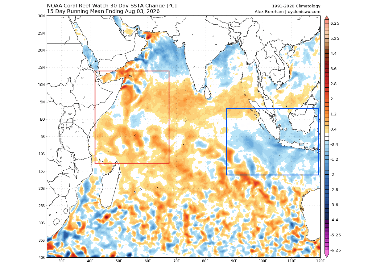
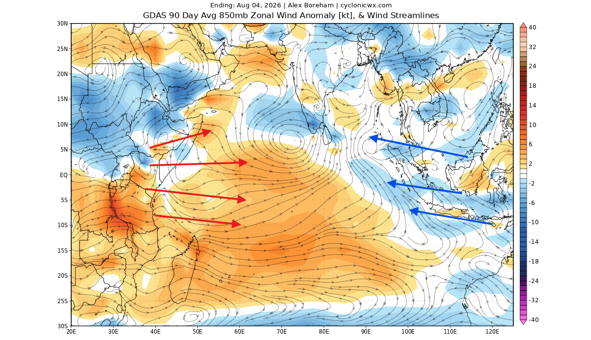
Simultaneously, shifts in zonal wind anomalies across the Indian Ocean triggered the initial stages of a positive Indian Ocean Dipole. Trade winds in the eastern Indian Ocean strengthened, driving surface water cooling, while weaker winds in the west permitted anomalous warming.
Autumn: Locking in the Atmospheric Engine
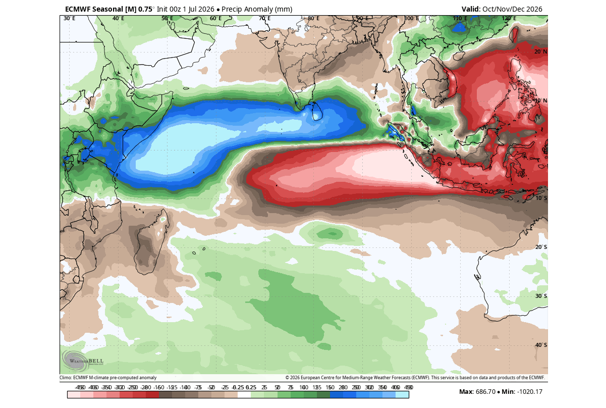
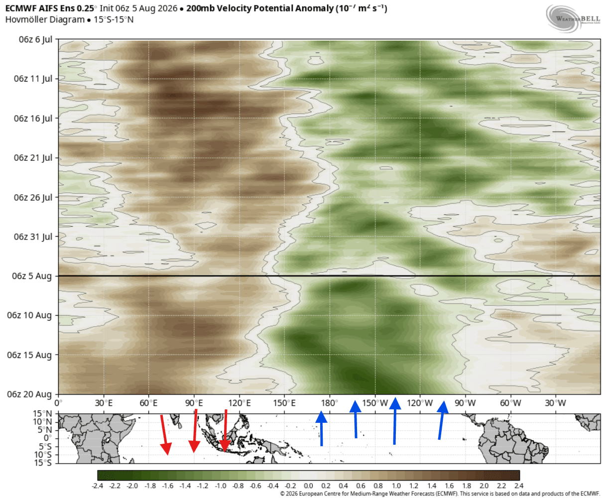
As the calendar turns toward autumn, both the Super El Niño and the positive IOD are projected to reach maturity. Climate analyses from late August onward show that the atmospheric response is fully engaged. Persistent rising air over the central Pacific combines with anomalous sinking air over Indonesia and the Indian Ocean. This establishes a dominant Walker circulation pattern that locks the global weather engine into a predictable configuration. Ensemble precipitation forecasts for autumn already display classic IOD footprints, characterized by massive rainfall deficits in the eastern Indian Ocean and excessive precipitation in the western basins.
Early Winter (December 2026): Jet Stream Realignment
By December, the tropical forcing translates into hemispheric pressure anomalies. High-pressure blocking ridges begin to anchor over Canada and the polar latitudes, while a deep, energetic trough carves out across the North Pacific. This configuration forces the jet stream into a split-flow pattern over North America, directing active storm tracks straight toward the southern and eastern United States.
Mid-to-Late Winter (January–February 2027): Peak Amplification
As winter peaks in January and February, the planetary wave train intensifies. Actual real-world weather data historically and dynamically outpaces computer model initializations during Super El Niño events, leading to aggressive winter storm development. The established pressure patterns lock in, ensuring that regions under the southern storm track experience frequent, high-impact winter weather events, while northern regions remain under the influence of anomalous ridging.
Supporting Data: Oceanographic and Atmospheric Diagnostics
The confidence in the Winter 2026/2027 outlook is derived from rigorous multi-model consensus and extensive historical analogs spanning more than six decades of climate data.
The Super El Niño Core and Kelvin Waves
Oceanographic analysis of the top 500 meters of the tropical Pacific reveals an extraordinarily deep core of warm anomalies. The NCEP CFSv2 and ECMWF seasonal models project peak sea surface temperature anomalies in the Niño regions to exceed the extreme +3°C to +4°C threshold, placing this event among the strongest El Niño episodes in recorded history. This massive pool of thermal energy acts as a continuous heat source, pumping excess moisture and energy into the troposphere.
The Positive IOD and Tropical Teleconnections
While El Niño dominates headlines, the positive IOD acts as a crucial secondary amplifier. Historically, a positive IOD frequently co-occurs with robust El Niño events, reinforcing the planetary-scale Rossby wave train that propagates out of the tropics. According to regression analyses of 65 years of climate data, this coupled teleconnection reliably generates a high-latitude blocking pattern over North America and a deepened trough over the southern tiers of the continent.
Official Responses and Meteorological Implications
As seasonal outlooks solidify, meteorological agencies and long-range forecasters are breaking down what this dual-ocean driver means for regional populations across the Northern Hemisphere.
North America: Split-Flow Weather and Snowfall Distribution
For the United States and Canada, the forecast points toward a stark geographical divide:
- Canada and the Northern U.S.: Dominant high-pressure ridging and northern blocking will keep temperatures well above normal across much of Canada, the Pacific Northwest, and the northern Great Lakes. Consequently, these regions face below-average seasonal snowfall totals, as polar air is largely deflected or prevented from settling into higher latitudes.
- The Southern and Eastern U.S.: An active, southward-displaced storm track fueled by the Super El Niño will drive above-normal precipitation across California, the Southwest, Texas, the Gulf Coast, and up through the East Coast. When periodic drops of cold air from the north intersect this rich moisture stream, the stage is set for heightened snowfall potential and severe winter storms across the Central Plains, Midwest, Mid-Atlantic, and interior Northeast.
Europe: Westerly Dominance and Milder Trends
Europe sits downstream from the primary North Atlantic wave train. ECMWF pressure anomaly forecasts for December through February suggest a strong north-to-south pressure gradient. This pattern favors an amplified westerly flow driven by persistent low-pressure systems moving across northern and northwestern Europe, contrasted with high-pressure influence over the Mediterranean and southern Europe.
- Temperatures: Most of the European continent is favored to experience above-normal temperatures due to the continuous influx of mild maritime air from the Atlantic.
- Precipitation and Snowfall: Above-normal precipitation is expected across northern and western Europe. However, broad, sustained snowfall anomalies remain unlikely for much of the lowlands due to the prevailing westerly regime. Snowfall potential will largely be restricted to higher elevations in central Europe and the far north/northeast, where occasional northerly dips in the jet stream can tap into colder air masses.
Conclusion: A Historic Climate Season Ahead
The convergence of a record-challenging Super El Niño and an active positive Indian Ocean Dipole guarantees that Winter 2026/2027 will not be a typical cold season. By coupling twin oceanic heat engines in the Pacific and Indian oceans, the global atmosphere has locked into a powerful, predictable planetary wave configuration.
While millions across Canada and northern Europe can anticipate a milder, less snowy winter, populations across the southern and eastern United States, alongside the higher elevations of Europe, must prepare for an active, storm-laden season defined by sharp temperature contrasts and high-impact weather events. As late-summer data continues to be refined, meteorological services worldwide will maintain continuous monitoring of this historic dual-ocean system.
