

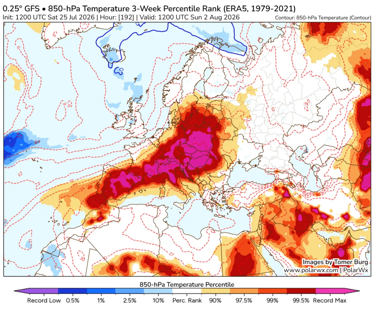
EUROPE — As the calendar turns from July to August 2026, the European continent is bracing for what meteorologists are identifying as a potentially historic escalation of excessive heat. Driven by a textbook atmospheric Omega block, a monstrous and long-lasting fourth heatwave of the season is surging northward from North Africa. A relentless "Heat Dome" is locking into place over Western Europe, Central Europe, and the Mediterranean basin, threatening to shatter long-standing temperature records and severely exacerbate ongoing environmental and public health emergencies.

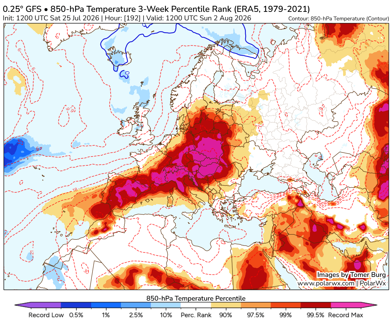
High-resolution global ensemble weather models indicate that mid- to upper-air thermal anomalies are tracking well into the 99th percentile. This sets the stage for a brutal, record-challenging meteorological event that will expand across the majority of the continent by the end of July and persist deep into August.
Main Facts: The Anatomy of a Historic Summer Event
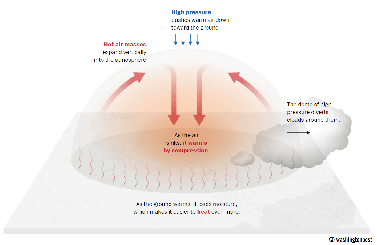
The primary catalyst for this severe weather episode is a sprawling upper-level ridge—colloquially known as a Heat Dome—that acts similarly to a lid on a pot. This system traps warm air at all levels beneath it, causing air masses to sink toward the ground, compress, and warm dramatically.
Key Meteorological Drivers:
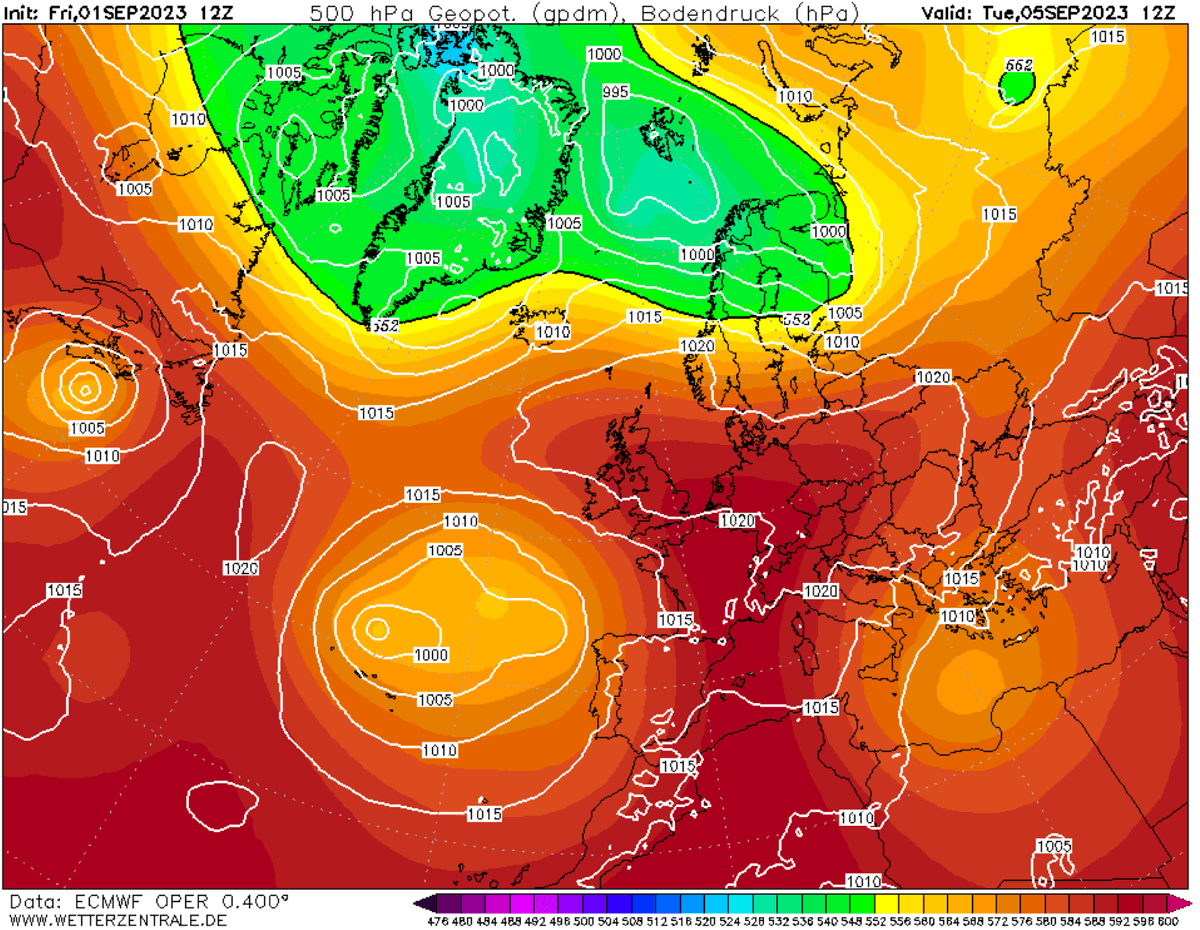
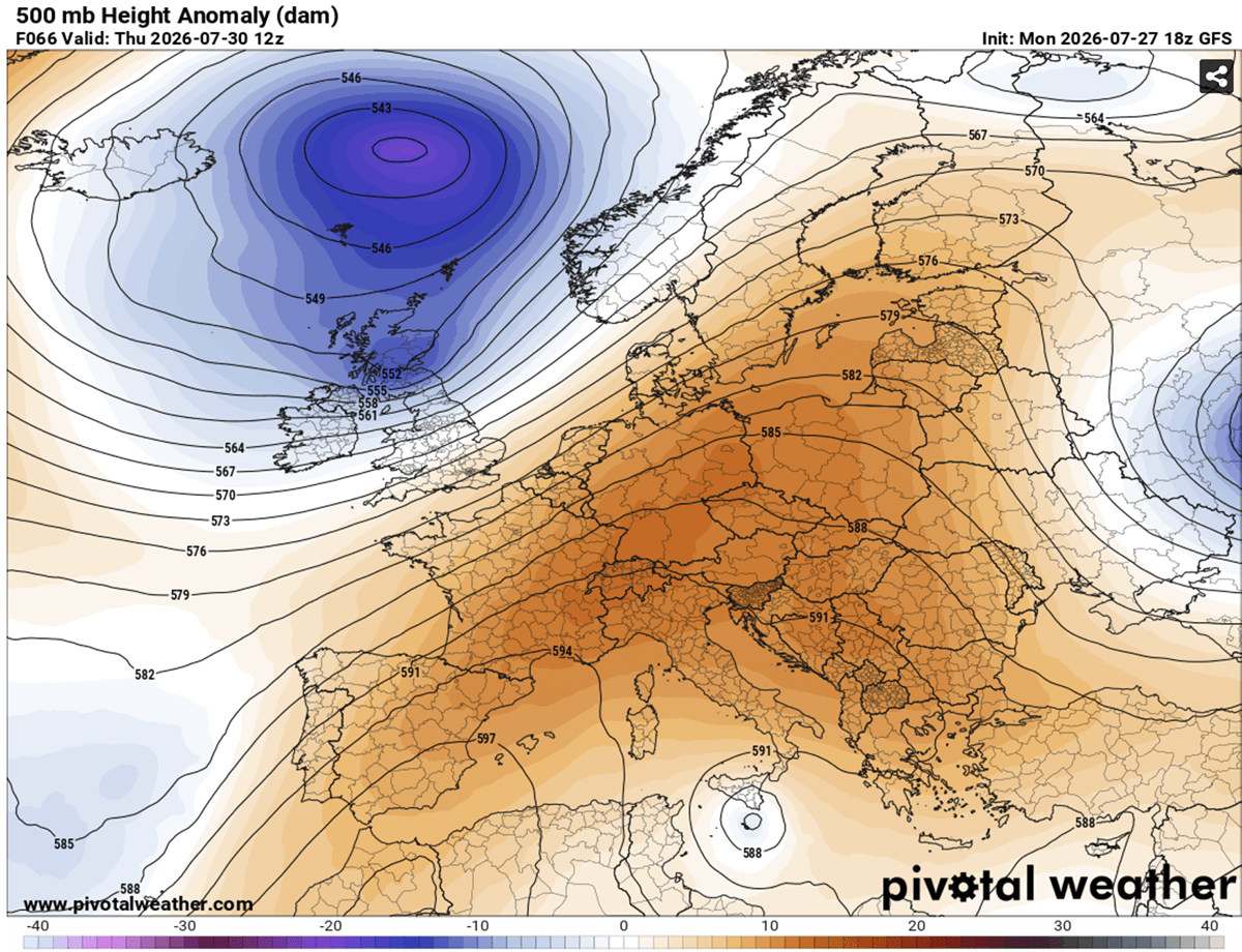
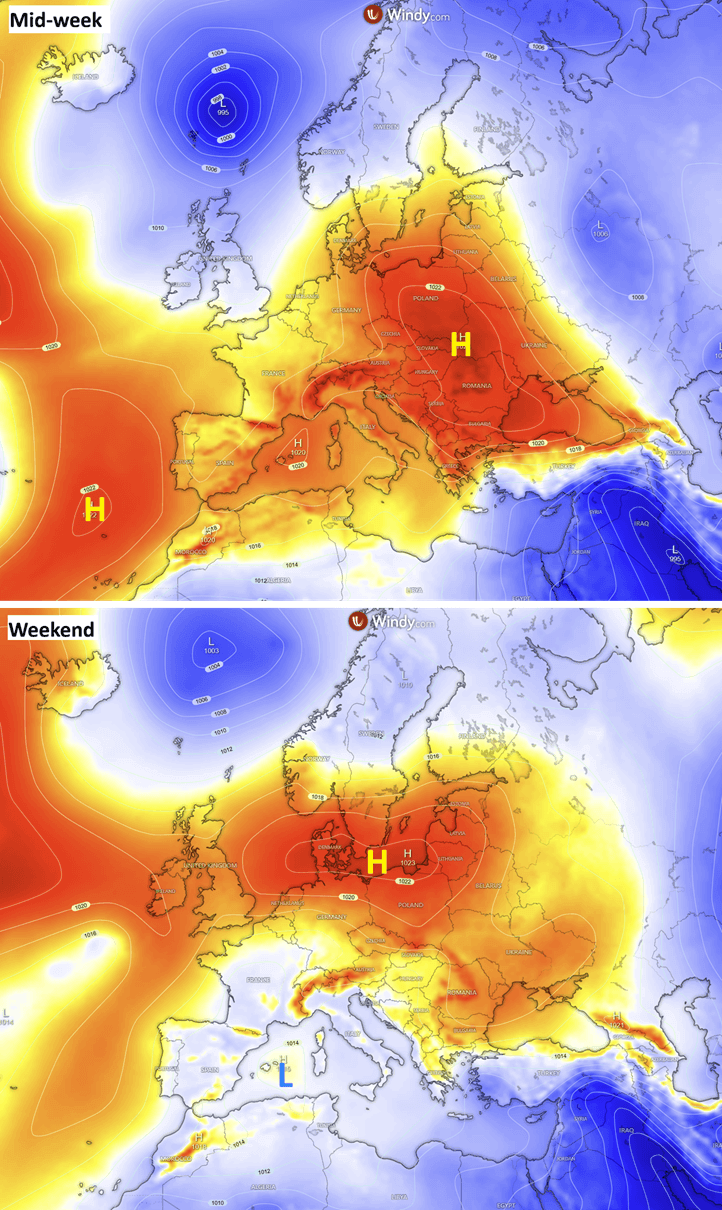
- The Omega Block: A stagnant blocking high-pressure system is currently parked over the heart of Europe, flanked by deep low-pressure systems over the North Atlantic and Russia.
- Saharan Air Plume: Exceptionally hot, dry air masses are being pumped straight from the Sahara Desert into the central and western portions of the continent.
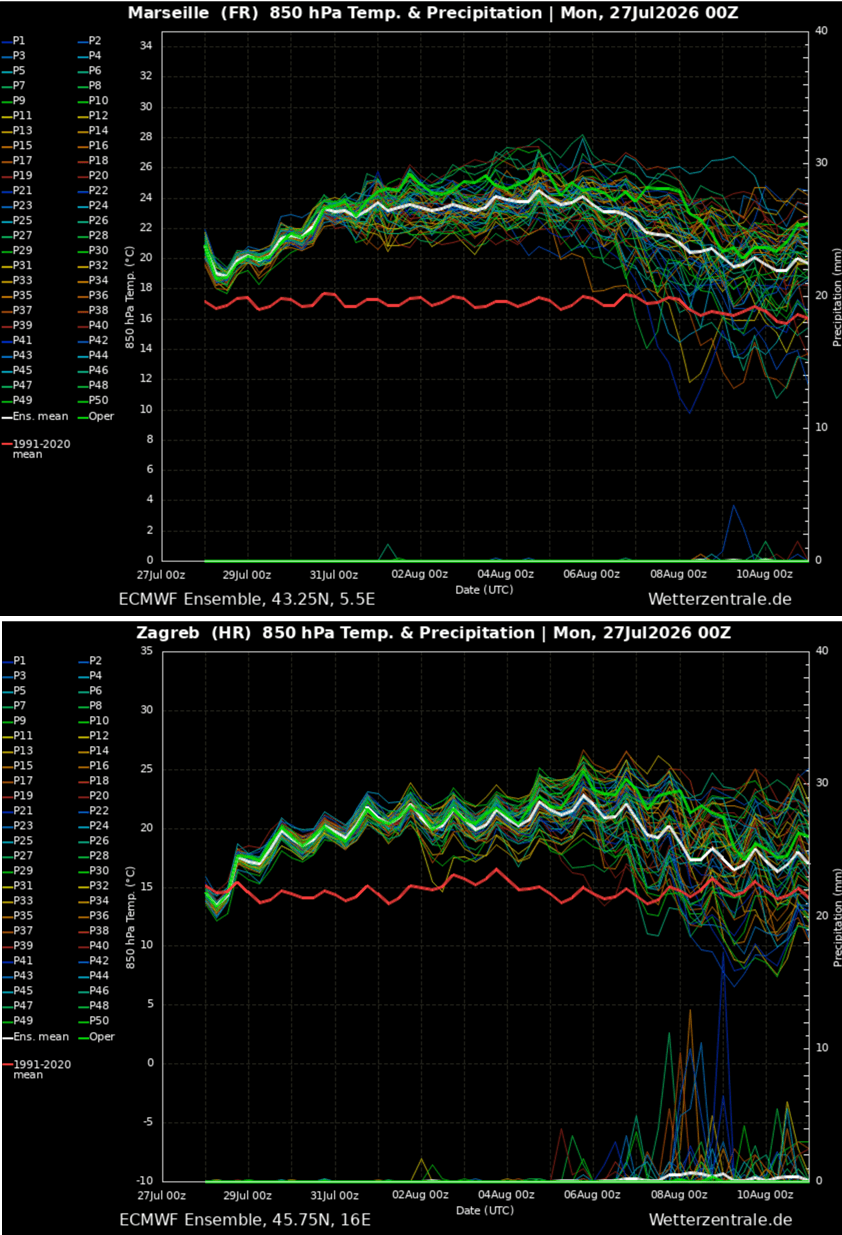
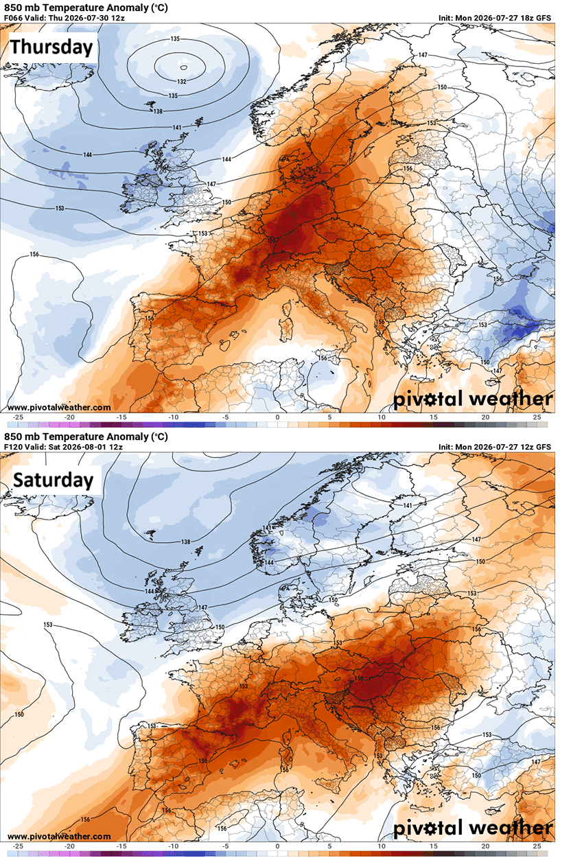
- Tropospheric Anomalies: Weather models suggest 850 mbar level temperatures could reach an extraordinary 25 °C to nearly 28 °C across a broad swath of Europe, with 500 mbar geopotential heights climbing to near-record levels.
- Geographic Spread: The core of the Heat Dome will initially center over the Iberian Peninsula and France before migrating eastward toward Central Europe, Italy, the Balkans, and eventually Eastern Europe.
Chronology: How the Heatwave Unfolds
The progression of this weather anomaly is mapped across distinct phases, dictating severe temperature spikes across different regions from mid-week through the following weekend.
Phase 1: Western Europe Peak (Mid-Week)
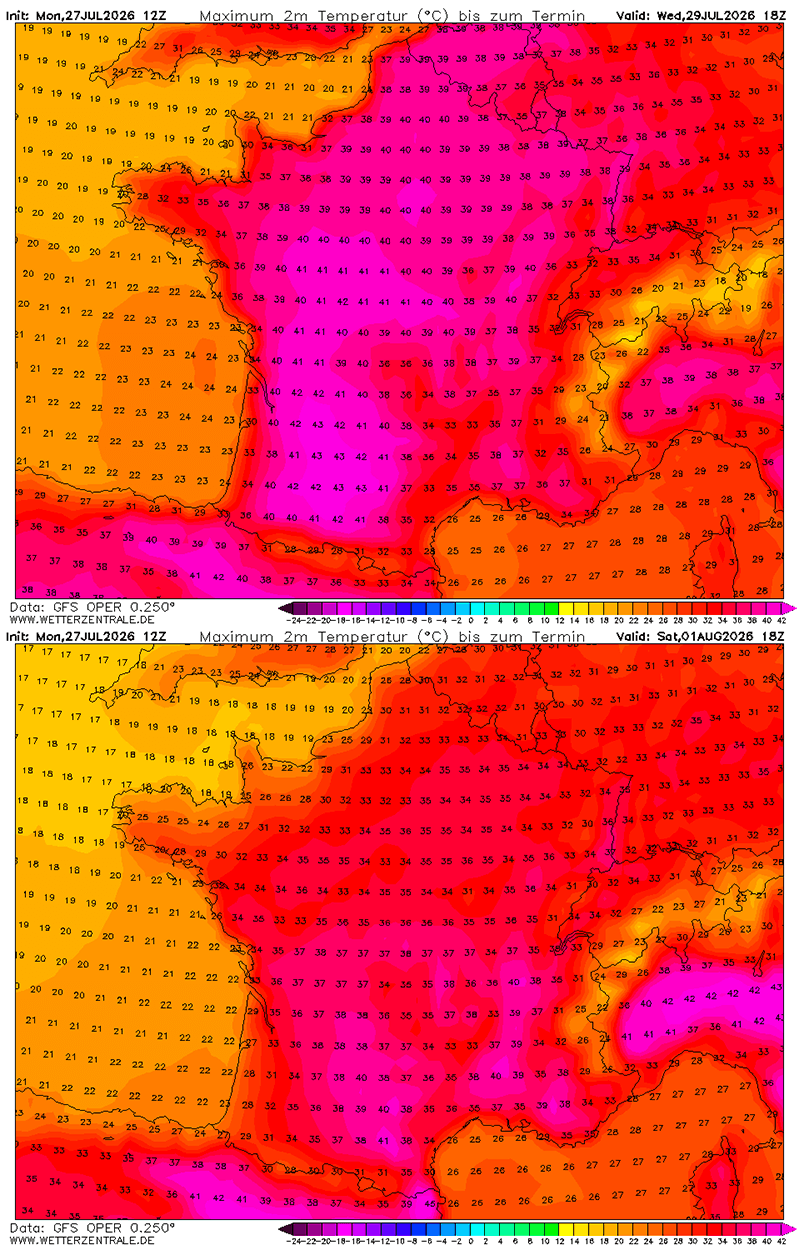
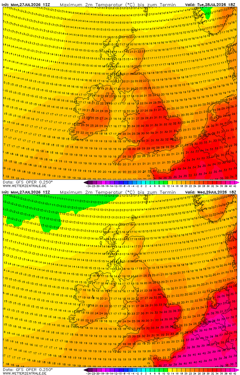
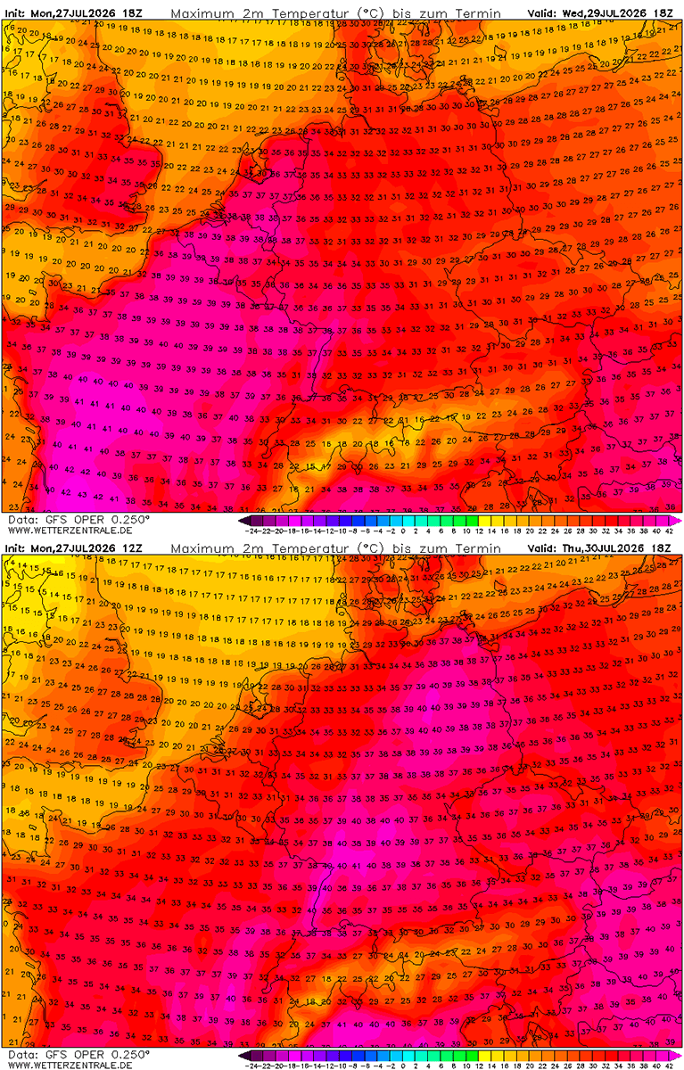
France, Spain, and Portugal are bearing the initial brunt of the intensifying ridge. On Wednesday, surface temperatures in western and central France are forecast to surge between 40 °C and 43 °C, while the remainder of the country experiences afternoon peaks ranging from 34 °C to 39 °C.
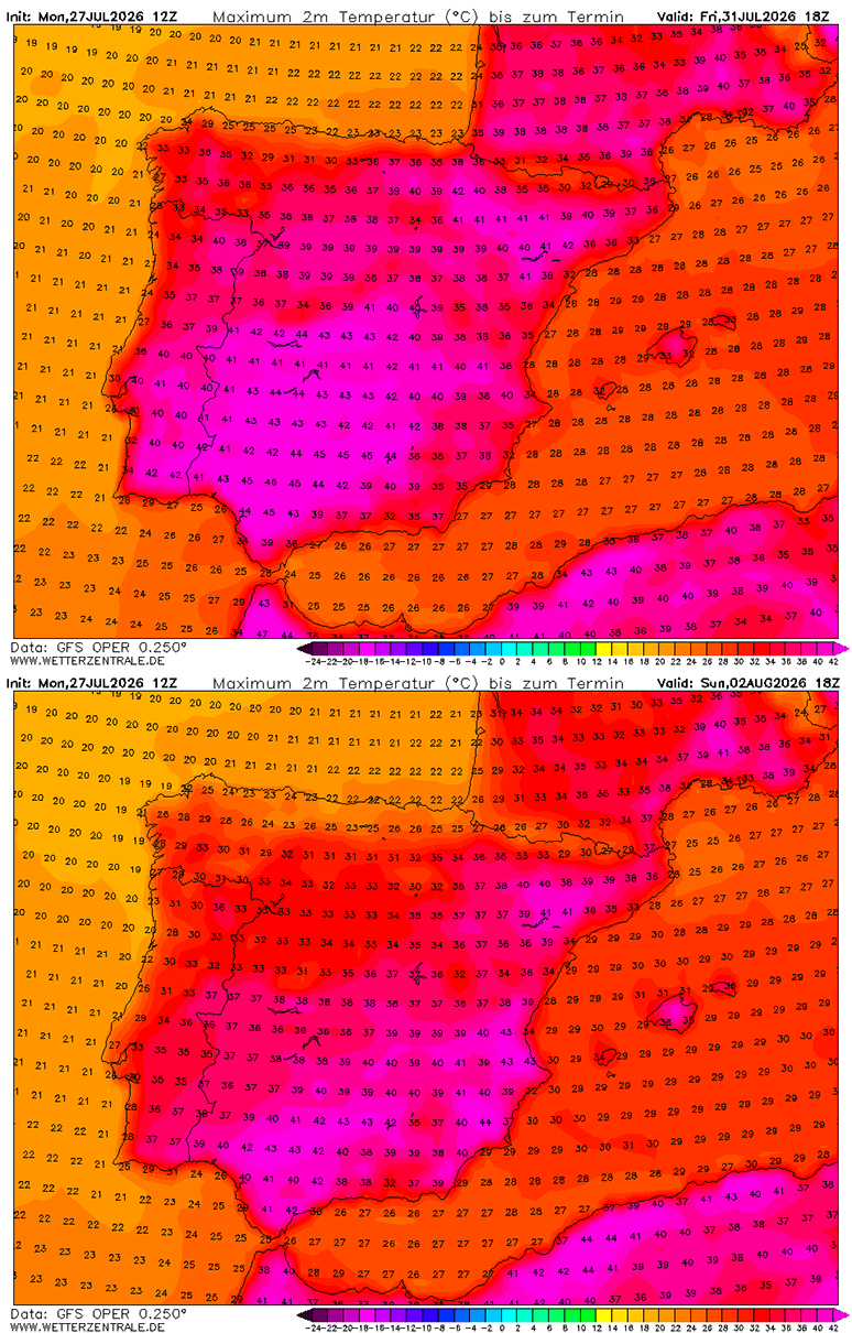
Simultaneously, the Iberian Peninsula is recording some of the most extreme temperatures of the season. Southern Portugal and south-central Spain face brutal conditions, with peak temperatures projected to reach between 42 °C and 46 °C in heat-prone lowlands due to exceptionally low relative humidity.
Phase 2: Central Europe, Italy, and the Balkans (Late Week to Weekend)
As the core of the ridge drifts eastward, its axis shifts toward Central Europe, Germany, and the Mediterranean.
- Germany and Benelux: Peak intensity is expected on Wednesday in the Benelux region and Thursday in Germany, where temperatures will climb into the upper 30s, occasionally touching 40 °C to 41 °C.
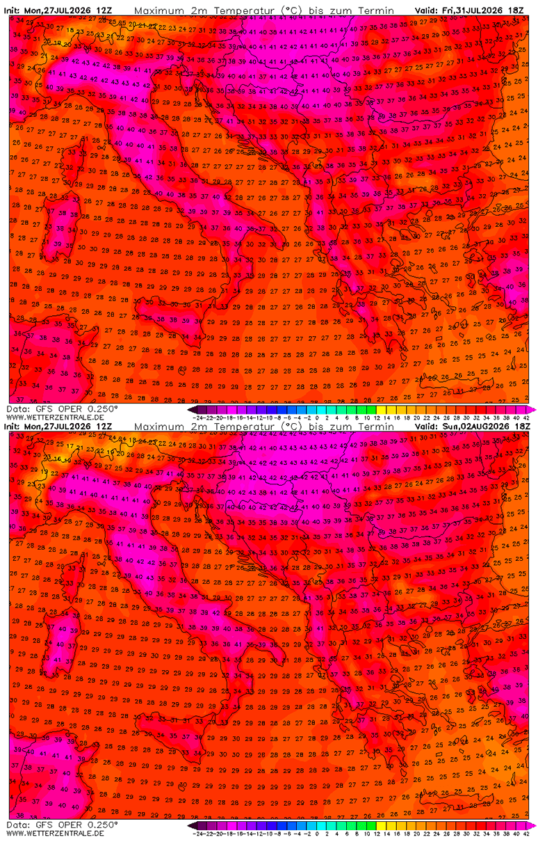
- Italy and the Balkans: North-central Italy (including the Po Valley and Tuscany), Slovenia, eastern Croatia, northern Bosnia and Herzegovina, north-central Serbia, Hungary, and western Romania will see readings soar past the 40 °C mark for multiple consecutive days.
- The British Isles: The United Kingdom, Wales, and Ireland will experience a shorter-term heat pulse, peaking on Tuesday and Wednesday with temperatures reaching 33 °C to 36 °C in south-central England before a maritime air mass brings relief from the west.
Phase 3: Eastern Europe Expansion (The Weekend)
By the weekend, the Heat Dome will expand eastward, pushing extremely hot air masses into Ukraine, Moldova, and Western Russia. Temperatures in these regions are projected to climb near 40 °C by Sunday, maintaining hazardous levels between 38 °C and 41 °C into the following week.
Supporting Data: Meteorological Statistics and Metrics
The scale of the 2026 summer heat dome is reflected in severe statistical thresholds tracked by European meteorological agencies:
- Surface Highs: Sea-level pressure is rising significantly across Europe beneath the persistent high-pressure dome, while weak-wind environments dominate through the end of July.
- Advection and Foehn Effect: As the surface high shifts toward Germany, Denmark, and the Baltic region over the weekend, an east-northeast flow will develop. This wind pattern will drive dry continental air toward the Mediterranean, causing further adiabatic warming via downslope Foehn effects.
- Nighttime Lows ("Tropical Nights"): Minimum overnight temperatures are forecast to remain trapped in the mid-to-upper 20s °C in many urban and lowland areas. Without standard nighttime cooling windows below 24 °C, physiological recovery for humans, livestock, and crops becomes severely compromised.
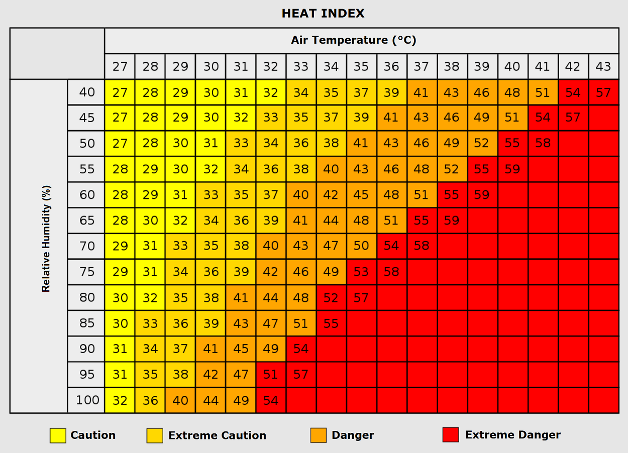
- Humidity and Heat Index: While the upcoming air mass is predominantly dry—with relative humidity plunging below 20 percent in several regions—areas experiencing higher humidity combined with 35 °C ambient temperatures could produce a perceived "Heat Index" approaching 50 °C.
Implications: Public Health, Ecological Crisis, and Wildfire Dangers
Beyond the alarming weather statistics, this prolonged heatwave carries severe secondary implications for human health, infrastructure, and the environment.
Public Health and the "Silent Killer"
Extreme heat remains one of the deadliest meteorological phenomena. Vulnerable populations—including the elderly, young children, and those with pre-existing cardiovascular or respiratory conditions—face heightened mortality risks. Outdoor laborers, such as agricultural workers and construction crews, are at extreme risk of heat exhaustion and heat stroke.
Furthermore, because centralized residential air conditioning remains relatively uncommon across much of Europe, hospitals and emergency rooms are bracing for spikes in heat-related illnesses, heart attacks, and strokes. The persistence of "tropical nights" denies populations the essential physiological relief required to recover from daily thermal stress.
Escalating Ecological Disasters and Wildfires
The combination of prolonged drought conditions, record-high temperatures, and relative humidity plunging below 20 percent has created tinder-box conditions across the continent.
- Southwestern Europe: Forests in Spain and southern France, already battling ecological strain, face explosive and uncontrollable wildfire risks.
- The Mediterranean and Balkans: As the dry east-northeast flow establishes over the weekend, increased winds will drastically elevate the ignition and rapid-spread potential for new wildfires across Italy, the Alpine region, and the western Balkan countries.
Official Responses and Outlook
Meteorological organizations, including ECMWF, GFS, Wxcharts, PivotalWeather, and Wetterzentrale, continue to monitor the persistent blocking high. Civil protection agencies across France, Spain, Italy, and Central Europe have issued high-level red and orange heat warnings, advising citizens to limit outdoor physical activity, stay hydrated, and check on vulnerable neighbors.
As the blocking high remains parked over Europe for what is projected to be nearly two weeks, forecasters warn that the atmospheric setup shows little sign of immediate breakdown. Authorities will continue to update emergency protocols as the situation evolves, with ongoing monitoring directed toward whether the Heat Dome will extend its grip further into mid-August 2026.
