

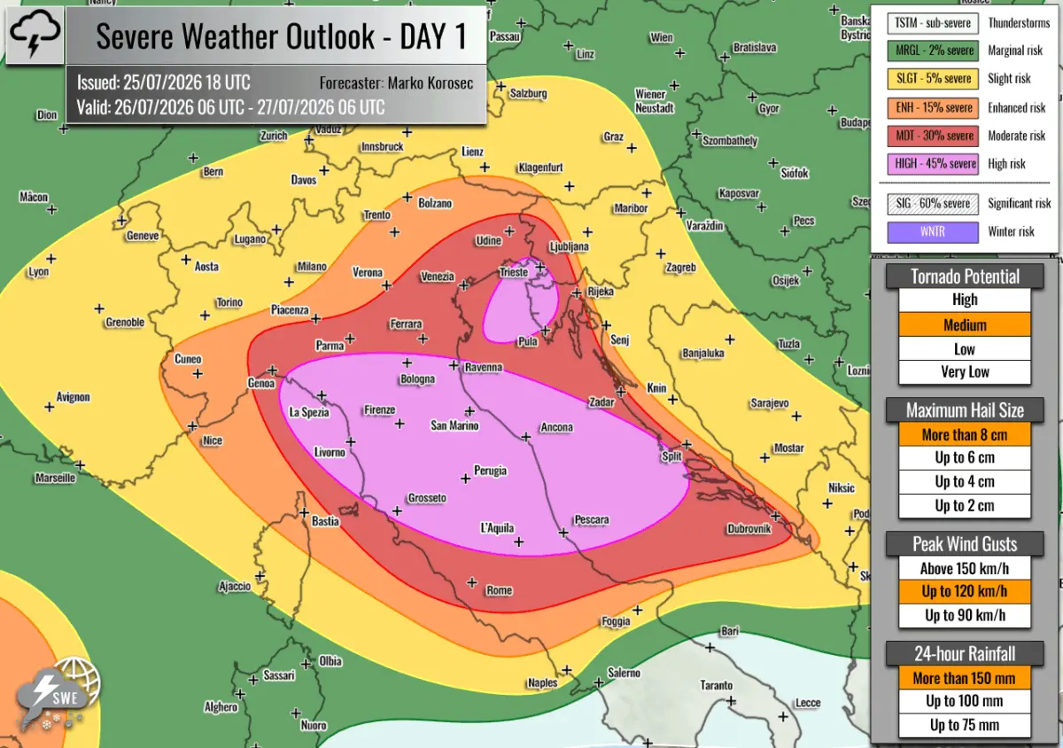
EUROPE — Meteorological authorities and severe weather forecasters have issued urgent warnings for a significant, highly volatile severe weather outbreak set to strike the north-central Mediterranean and the Adriatic Sea region. Driven by a volatile combination of extreme seasonal heat, robust atmospheric instability, and deep wind shear, the upcoming storm system poses a multi-hazard threat to millions of residents and peak-season tourists alike.
According to the latest forecasts issued by Severe Weather Europe and forecaster Marko Korošec, the severe weather window is officially valid from 06:00 UTC on Sunday, July 26, to 06:00 UTC on Monday, July 27, 2026. Rare HIGH risk levels—accompanied by surrounding Moderate (MDT) and Enhanced (ENH) designations—have been triggered for several regions, highlighting a dangerous convergence of giant hail, destructive straight-line winds, tornadoes, and catastrophic flash flooding.
Main Facts: A Volatile Meteorological Convergence
The impending severe weather outbreak is the result of a classic, highly energetic summer setup characterized by contrasting air masses colliding over a remarkably warm marine environment.
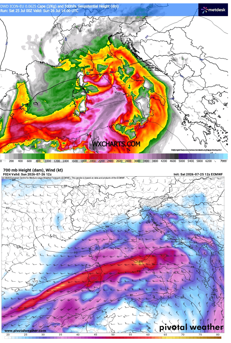
At the macro-synoptic scale, a deep upper-level low-pressure system has entrenched itself over northern Europe, locked in place between two formidable blocking atmospheric ridges: one stationed over the North Atlantic and another over Russia. Directly beneath this pattern, a secondary upper-level wave is tracking out of central Europe toward the southeast. Simultaneously, a subtropical ridge to the south is shifting eastward, opening the door for this dynamic wave to cross the Alps and interact directly with the Mediterranean basin.
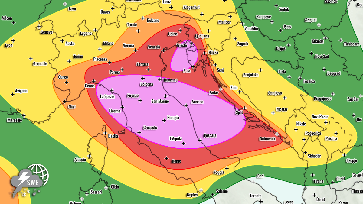
At the surface, an extensive low-pressure system centered over western Norway is steering a robust cold front toward Southern Europe. As this frontal boundary sweeps from west to east across the Alps, northern Italy, and into the Adriatic Sea, it encounters an atmosphere primed by an ongoing, severe Mediterranean heatwave.
Pre-frontal southwesterly winds are aggressively pumping high-moisture air from the central Mediterranean into the northern sectors of the sea. The interaction of high surface dewpoints and blistering ambient temperatures has generated moderate to locally extreme atmospheric instability. Mixed-layer Convective Available Potential Energy (MLCAPE) values are projected to reach staggering levels of 2,000 to over 3,000 Joules per kilogram (J/kg) over the Tyrrhenian, Ligurian, and central Adriatic Seas.
When paired with intense mid-level jet streams providing deep wind shear, this environment creates a textbook setup for explosive, organized thunderstorm development. Forecasters emphasize that the primary hazards will include:
- Giant Hail: Hailstones ranging from 6 cm to well over 10 cm (giant scale) driven by intense updrafts.
- Destructive Winds: Severe, straight-line convective wind gusts capable of structural damage and widespread treefalls.
- Flash Flooding: Exceptional precipitable water (PWAT) values between 45 mm and 60 mm will fuel torrential rainfall rates, leading to life-threatening flash floods, particularly in complex terrain and coastal zones.
- Tornadoes: Enhanced low-level shear and high storm-relative helicity will support a notable threat of tornadoes and waterspouts.
Chronology: The Evolution of the Storm System
The severe weather event is expected to unfold in rapid, highly destructive phases starting early Sunday morning and continuing through Monday morning.
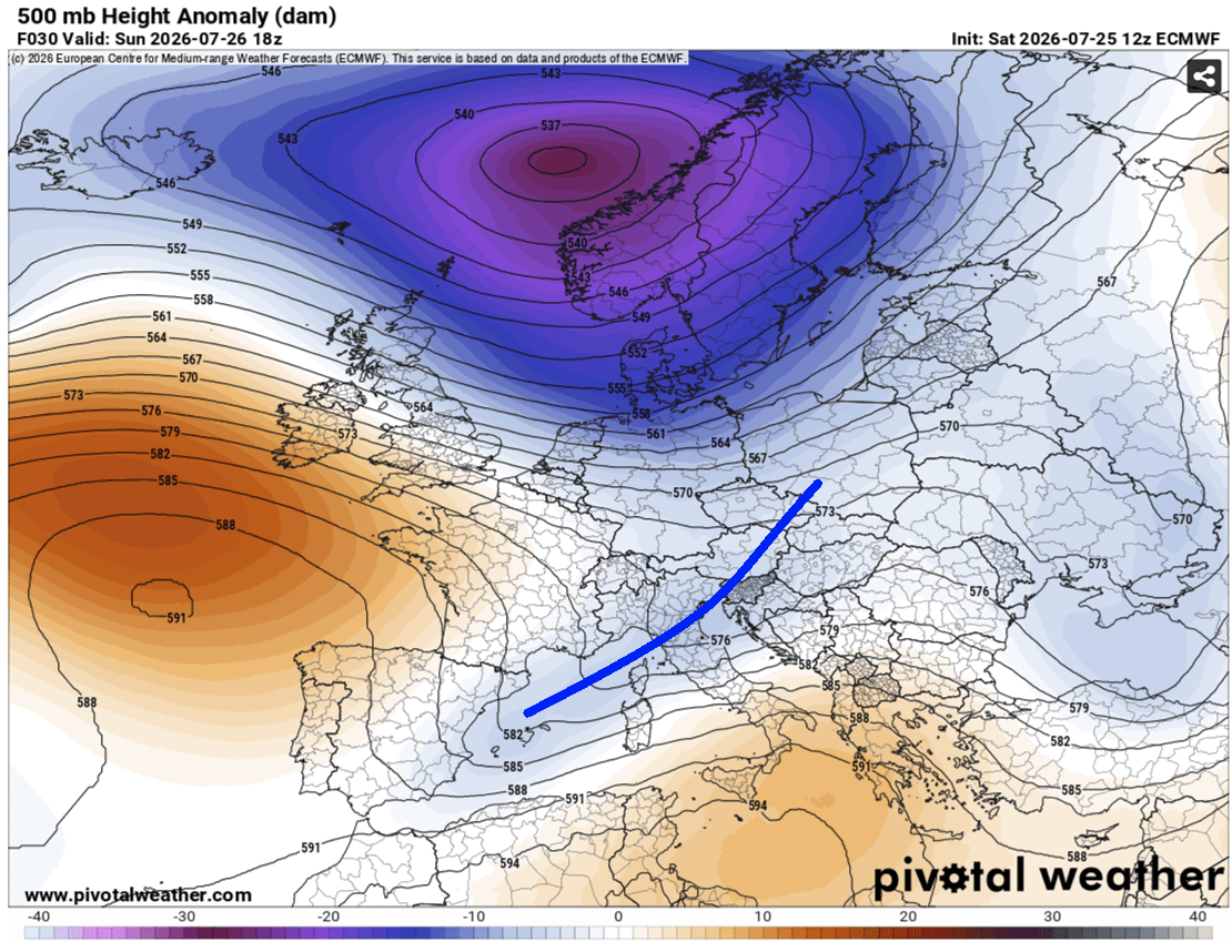
Phase 1: Sunday Morning — Ligurian Bay and Northern Italy
The outbreak is projected to ignite during the early morning hours of Sunday, July 26. Initial convective development will spark over the Ligurian Bay and rapidly propagate eastward toward the rugged terrain of the north-central Apennines.
As these storms encounter high moisture and steep lapse rates, they are forecast to quickly organize into intense supercells and training multicell clusters. Moving across northern Italy, these storms will interact with complex topography, maximizing the threat of excessive rainfall, massive hail, and localized flooding before noon.
Phase 2: Sunday Afternoon — The Adriatic Sea and Western Balkans
By Sunday afternoon, the primary forcing shifts toward the Adriatic Sea, northwest Croatia (particularly the Istria peninsula), and southwestern Slovenia. High-resolution meteorological models indicate that a persistent low-level jet and stationary surface convergence zones will anchor powerful training cells over these coastal areas.
During this peak 6-to-12-hour window, storm systems are expected to merge into massive convective clusters, sweeping east-northeastward. This phase carries the highest risk of prolonged, torrential downpours capable of dropping 100 mm to 200 mm of rain over a wide area, severely threatening vulnerable coastal communities during the height of the summer tourist season.
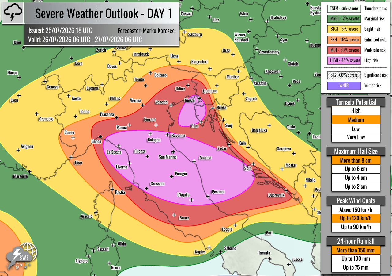
Phase 3: Sunday Night into Monday Morning — Moving East
As the upper-level wave continues its eastward trajectory across the Balkan Peninsula, thunderstorm activity will gradually begin to weaken or transition into broader rain shields, though localized severe threats will persist into the early hours of Monday, July 27, before the system finally pushes out of the region.
Supporting Data and Regional Risk Breakdowns
Meteorological agencies have delineated specific threat zones to target public safety messaging and emergency preparation.
Primary HIGH Risk Zones
- Central and Northern Italy into the Central Adriatic Sea: This zone faces the most concentrated threats of severe damaging winds, very large to giant hail, torrential rainfall, and a significant risk of tornadoes. The western portions of this zone exhibit the highest storm-relative helicity, maximizing the tornado threat.
- Northeast Adriatic Sea, Northwest Croatia (Istria), and Southwest Slovenia: This region is singled out primarily for catastrophic flash-flooding potential driven by training storms and high PWAT values, alongside severe winds, large hail, and waterspouts/tornadoes along the coast.
Surrounding MDT, ENH, and SLGT Risk Areas
Surrounding the primary purple HIGH risk zones, Moderate (MDT), Enhanced (ENH), and Slight (SLGT) risks have been issued for southern and western Croatia, western and central Slovenia, west-central Austria, southern Switzerland, and remaining parts of north-central Italy. While storm coverage here is expected to be slightly lower than in the core high-risk zones, these areas remain vulnerable to severe winds, large hail, and localized heavy rain.
Secondary Outbreak Zones Across Europe
While the Mediterranean is the epicenter of this weekend’s severe weather, other parts of Europe are also under close watch:
- Western Mediterranean (Spain and the Balearic Islands): An ENH risk has been issued for isolated severe storms capable of producing severe winds, large hail, and torrential rainfall along the southern edge of the upper-level wave.
- Central Europe (Netherlands, Northern Germany, Poland): A SLGT risk highlights scattered storm activity capable of producing strong winds and marginal hail.
- Southwestern Russia: A large ENH/SLGT risk area has been established where high instability and strong shear will support discrete, highly organized supercells capable of producing damaging winds, torrential rain, large hail, and potential tornadoes.
Official Responses and Civil Protection Preparedness
With the forecast locking in during the peak of the European summer holiday season, civil protection authorities, local municipalities, and emergency response agencies across Italy, Slovenia, and Croatia have been placed on high alert.
Governments and meteorological services are strongly urging residents and tourists to monitor local weather alerts continuously and avoid outdoor recreational activities, camping, or maritime navigation in high-risk zones during Sunday and Monday.
In coastal Istria and the broader Adriatic basin—where tens of thousands of vacationers are currently visiting campsites, beaches, and coastal towns—local authorities are preparing contingency plans for rapid evacuations should flash flooding or severe wind squalls materialize as predicted. Emergency services have positioned high-capacity water pumps, rescue watercraft, and personnel in strategic corridors to respond swiftly to potential urban inundations and river overflows.
Implications: Infrastructure, Tourism, and Climate Context
The severity and timing of this meteorological event carry profound implications for the affected regions:
- Tourism and Economic Impact: Striking during late July, the outbreak threatens critical seasonal tourism infrastructure. Coastal regions in Croatia and Italy packed with holidaymakers face severe disruptions to transport networks, maritime travel, and outdoor events. Power outages caused by straight-line winds could impact accommodation providers and regional commerce.
- Agricultural Damage: The anticipated occurrence of giant hail (exceeding 10 cm in diameter) and torrential downpours poses an existential threat to regional agriculture, including vineyards, olive groves, and seasonal crops across northern Italy and the Balkans. Farmers have been advised to secure equipment and protective netting where possible.
- Infrastructure Stress: Urban drainage systems, already tested by prolonged summer heatwaves and dry soils that reduce initial water absorption capacity, will likely be overwhelmed by the forecast rainfall rates of 100 to 200 mm, increasing the risk of mudslides, structural damage, and bridge closures in mountainous and low-lying areas alike.
- Broader Climatic Patterns: Meteorologists note that the extreme instability fueling this event—driven by anomalously high sea surface temperatures across the Mediterranean—underscores a growing frequency of high-impact, volatile convective outbreaks in Southern Europe during the summer months. As marine heatwaves intensify, the baseline energy available for severe weather events of this magnitude continues to rise, posing long-term adaptation challenges for regional forecasting and civil defense infrastructure.
