

EUROPE — After enduring a historic, relentless stretch of excessive heat that gripped the continent, a dramatic and welcome atmospheric shift is currently sweeping across the eastern half of Europe. Central Europe, the Balkans, and parts of Southern Europe—regions that recently faced intense heat stress, urban heat island effects, and consecutive tropical nights—are experiencing a profound and sharp temperature downturn.
While millions of residents and tourists welcome this sudden respite, meteorologists note that the sharp transition brings a complex mix of meteorological phenomena, including gusty winds, localized severe thunderstorms, and a persistent, high-risk wildfire threat due to prolonged antecedent dryness.
Main Facts: A Sudden Reversal of Fortune
The overarching meteorological narrative for late July 2026 is one of stark contrasts. While southwestern Europe—specifically Spain and Portugal—continues to bake beneath relentless heatwaves with temperatures soaring into the low 40s degrees Celsius, Central, Eastern, and Southeastern Europe are experiencing a sprawling, unseasonably cold wave.
- Temperature Plunge: Daytime highs across much of Central and Eastern Europe have dropped significantly, remaining comfortably below 30°C. By mid-to-late week, temperatures in countries such as Poland, Slovakia, Czechia, Austria, Slovenia, and Croatia are tracking 4°C to 8°C below historical averages.
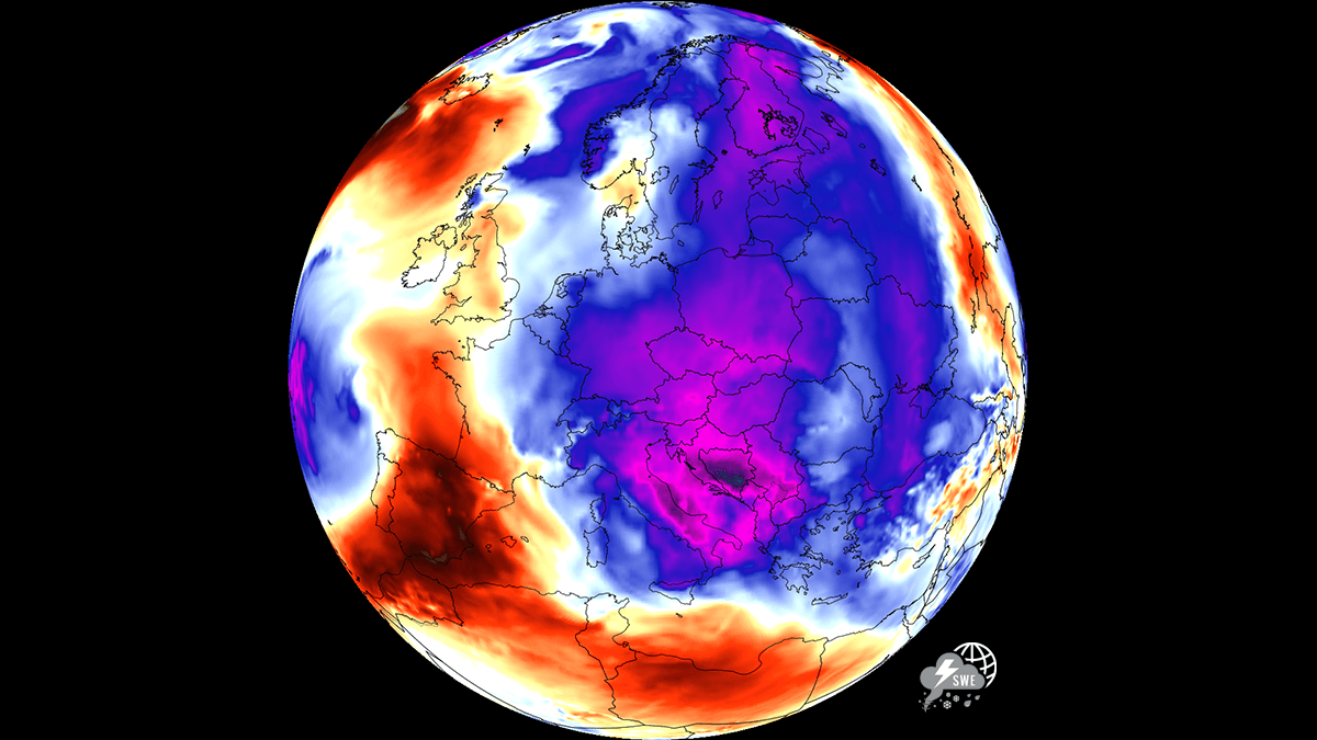
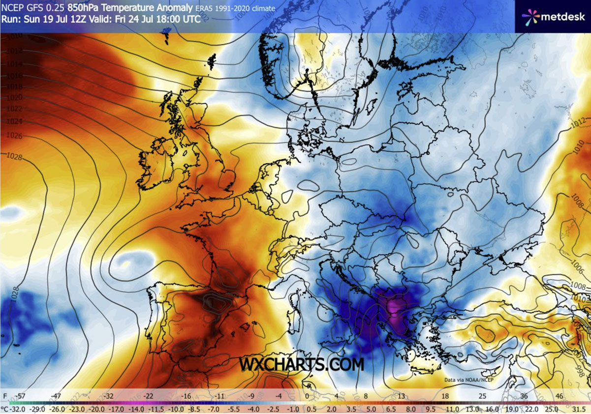
- The Southern Anomaly: By Friday and Saturday, the core of this cold wave is projected to dig deep into the southern Balkans, southern Italy, and Greece, producing staggering temperature anomalies of 10°C to 12°C below normal in the lower layers of the atmosphere.
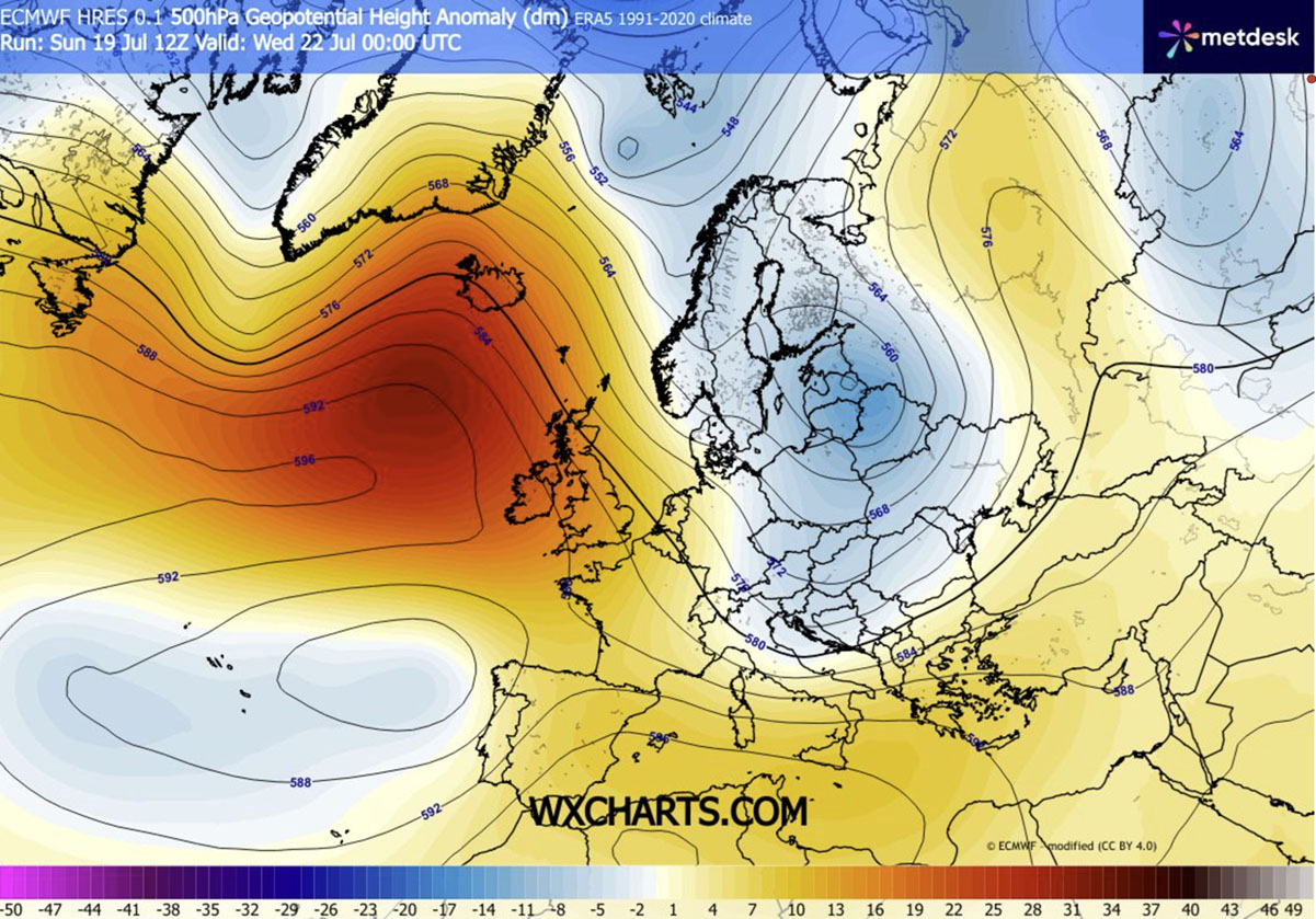
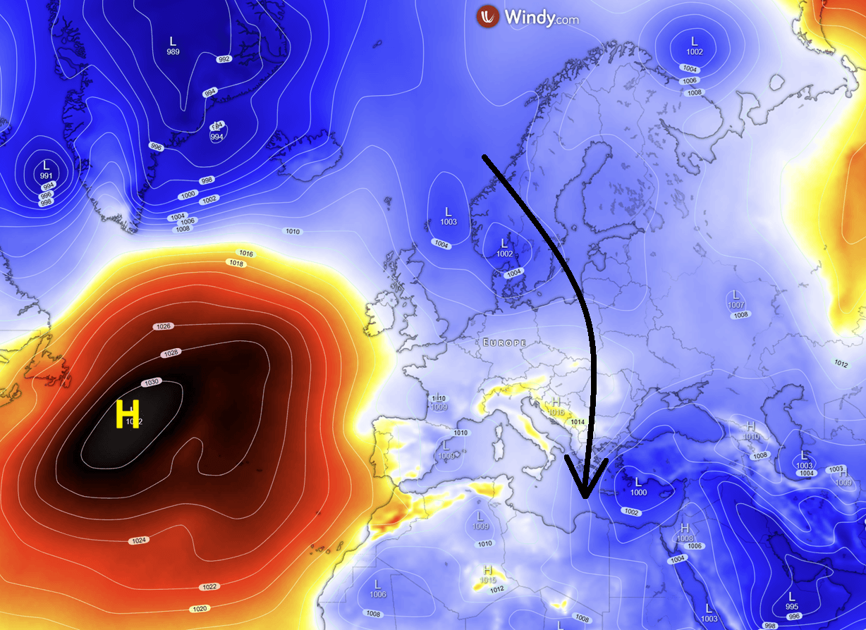
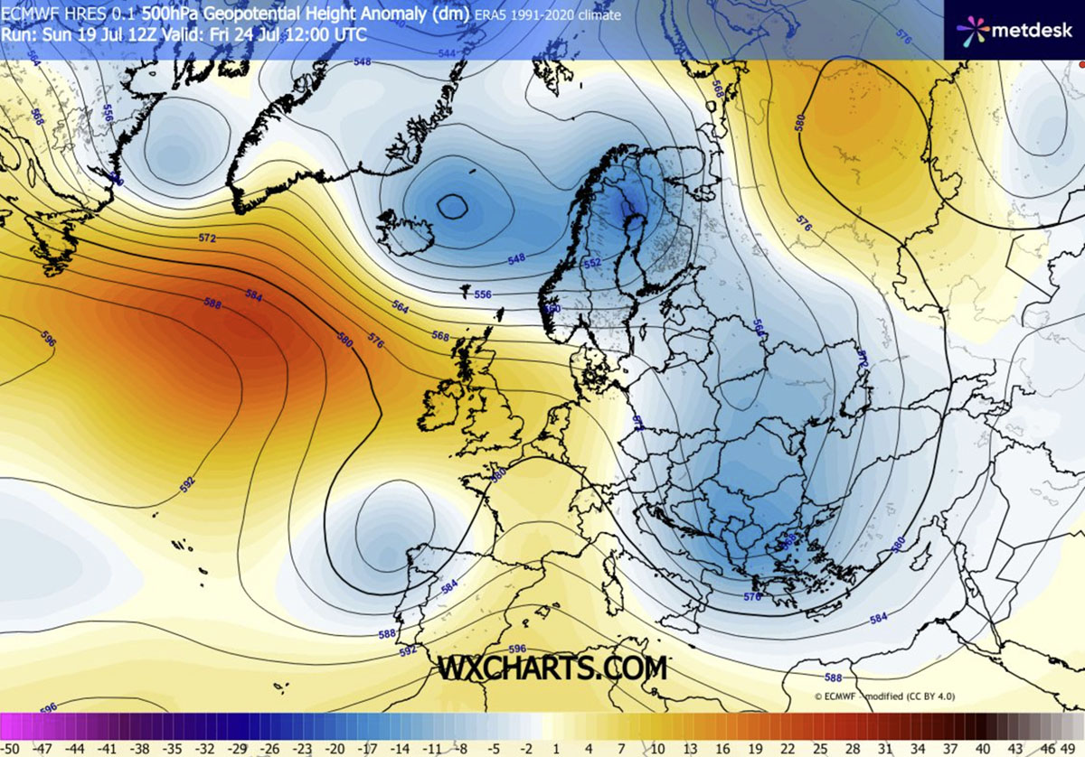
- Atmospheric Drivers: The pattern change is governed by a strengthening upper-level ridge over the Atlantic Ocean. This high-pressure blocking mechanism has forced a deep, dynamic low-pressure trough to develop over northern Europe, funneling a meridional flow of cold, unstable air masses far to the south.
- Colliding Air Masses: The boundary between the invading cold air and the lingering Mediterranean heat is triggering high atmospheric instability, sparking scattered severe thunderstorms, heavy downpours, and localized flooding risks from Italy across to the southern Balkans and the Black Sea region.
Chronology of the Weather Pattern Flip
The evolution of this atmospheric turnaround has unfolded rapidly through the week, shifting the continent from a state of heat-stress emergency to a dynamic, windy, and refreshingly cool regime.
Early Week: The Upper-Level Transition
The transformation began as an upper-level ridge solidified over the Atlantic, effectively establishing a blocking pattern. This structural shift forced a deep cold-air reservoir over northern Europe to break containment and surge southward. A robust cold front swept across the continent’s midsection through Tuesday and Wednesday, clearing out the stagnant, superheated air masses that had settled over urban centers.
Mid-Week: Central and Eastern Europe Cool Down
By Wednesday and Thursday, the leading edge of the cold wave fully engulfed Central and Eastern Europe. Countries from the Benelux union and Germany down through Poland and the northern Balkans experienced a sharp drop in both maximum and minimum temperatures. Morning and nighttime lows plummeted into the low-to-mid 10s (°C), offering much-needed relief to overheated buildings, infrastructure, and urban populations that had struggled to cool down during weeks of tropical nights. Daytime highs stabilized in the comfortable low-to-mid 20s (°C).
Late Week: Deep Penetration into the Balkans and Mediterranean
As the week progresses toward Friday and Saturday, the core of the upper-level trough deepens further, driving the cold wave into the southern Balkans, southern Italy, and Greece. Here, the temperature anomaly reaches its zenith. Simultaneously, the sharp thermal gradient between the cool incoming northerlies and the warm surface waters of the Adriatic, Ionian, and Black Seas is supercharging atmospheric instability. This dynamic environment is setting the stage for organized thunderstorm clusters, sudden downpours, and gusty winds across the target zones.
Supporting Data and Meteorological Analysis
Advanced meteorological models and charts illustrate the sheer scale of this July cold wave, detailing pressure anomalies, thermal deviations, and wind dynamics.
Pressure Patterns and Meridional Flow
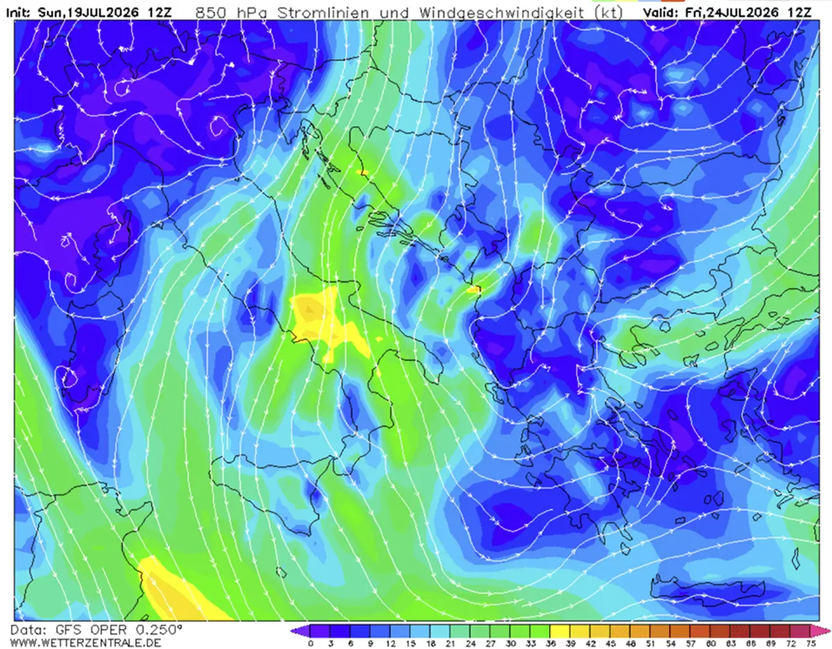
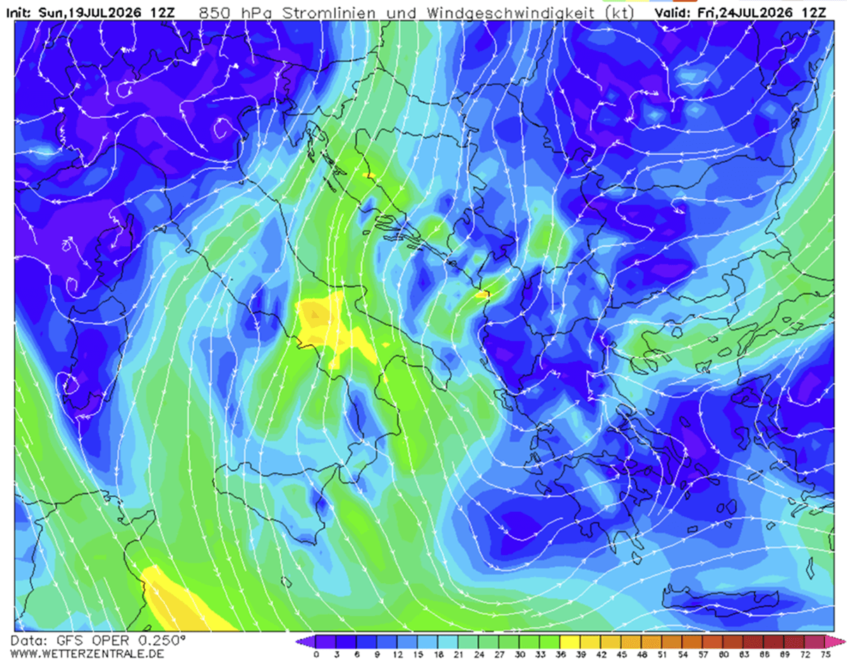
The surface pressure response mirrors the upper-level geopotential falls to the east and rising pressures under the western Atlantic ridge. This configuration establishes a distinct meridional flow pattern. Instead of the typical west-to-east zonal progression, air masses are being dragged from the high latitudes of the far north, rounding the western block, and plunging directly southward toward the Mediterranean basin.
Temperature Anomalies (850 mbar and 2M)
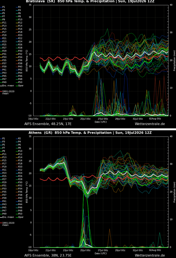
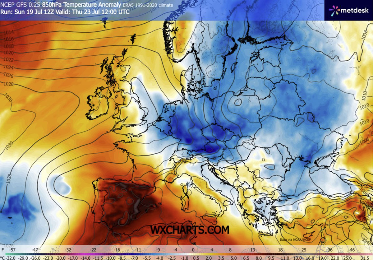
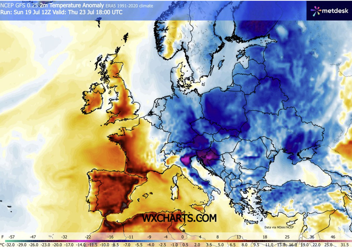
At the 850 mbar level (roughly 1,500 meters above sea level), thermal charts reveal a massive pool of sub-normal air spreading across the eastern half of the continent. By Thursday, widespread negative anomalies of 4°C to 8°C dominate Central Europe. By Friday, the core shifts southward, unleashing surface and lower-troposphere anomalies of 10°C to 12°C below normal across Greece and the southern Italian peninsula.
At the 2-meter surface level, minimum temperatures ($textTtextmin$) are dipping into the teens across wide swaths of the interior, particularly in sheltered valleys where clear, windless nights allow for optimal radiational cooling. Conversely, daytime maximum temperatures ($textTtextmax$) are heavily suppressed, keeping peaks in southern Italy, Greece, and Turkey restricted to the low-to-mid 30s rather than the dangerous extreme values typical of peak summer.
Wind and Precipitation Dynamics
The tight pressure gradient established between Western European high pressure and Eastern European low pressure is driving robust surface winds from Wednesday through Saturday. While these winds aid in maintaining the refreshing feel of the air mass, they introduce a severe secondary hazard.
Precipitation maps indicate that while the cold front is squeezing out beneficial moisture—producing healthy rainfall totals across Ukraine, Romania, and parts of the southern Balkans—the overall dryness of the incoming air mass combined with high wind speeds creates an explosive formula for wildfire propagation.
Official Responses and Civil Protection Warnings
Emergency management agencies, meteorological institutes, and civil protection authorities across Central and Southeastern Europe have issued a mixed portfolio of advisories in response to the sudden weather shift.
- Wildfire Hazard Warnings: Despite the drop in ambient temperatures, national forestry and firefighting services in countries like Croatia, Greece, Italy, and Hungary have maintained red-tier wildfire alerts. Authorities emphasize that cumulative drought stress from weeks of prior heatwaves cannot be erased by a single cold front, and strong, dry winds significantly elevate the risk of rapid fire spread.
- Severe Weather and Flash Flood Alerts: Meteorological offices in the southern Balkans and Italy have issued localized yellow and orange warnings for severe convective storms. Civil protection agencies are advising motorists and local municipalities to prepare for sudden downpours, urban flash flooding, and potential hail associated with the frontal clashes.
- Tourism and Public Health Guidance: With the peak summer tourism season in full swing, public health officials have transitioned from heat-health action plans to advising tourists in outdoor settings to prepare for rapidly changing conditions, including cooler mountain weather, windy coastal environments, and sudden disruptions from severe thunderstorms.
Implications for Agriculture, Infrastructure, and Ecosystems
The abrupt transition from extreme, persistent heat to an unseasonal cold wave carries profound implications across multiple sectors of society and the natural environment.
Urban Infrastructure and Energy Grids
For weeks, urban populations in major metropolitan centers—including Warsaw, Budapest, Bucharest, and Belgrade—faced severe urban heat island effects that strained electrical grids due to constant, maximum-capacity air conditioning usage. The arrival of the cold wave offers immediate relief to energy providers, drastically reducing peak electricity demand and allowing overheated urban fabric to dissipate accumulated thermal energy.
Agricultural Stress and Crop Recovery
The agricultural sector faces a nuanced reality. On one hand, the moderation of temperatures halts the immediate escalation of heat-induced crop stress, wilting, and soil moisture evaporation. On the other hand, prolonged drought conditions mean that the scattered nature of thunderstorm rainfall will not uniformly replenish depleted aquifers. Furthermore, sudden localized downpours risk causing agricultural damage via hail or soil erosion on hardened, dry earth.
Tourism and Outdoor Recreation
For the millions of vacationers currently populating European beaches, mountain trails, and historic city centers, the weather pattern shift represents a dramatic change of pace. While outdoor sightseeing and strenuous activities become much more manageable under 20-degree and low-30-degree daytime highs, coastal visitors and sailors must remain vigilant regarding sudden squalls and hazardous marine winds driven by the deep low-pressure trough.
As the atmospheric pattern solidifies, meteorologists continue to monitor the persistent Atlantic blocking high, which suggests that while southwestern Europe remains locked in intense heat, the eastern half of the continent will enjoy this refreshing, albeit turbulent, interlude well into the coming weekend.
