

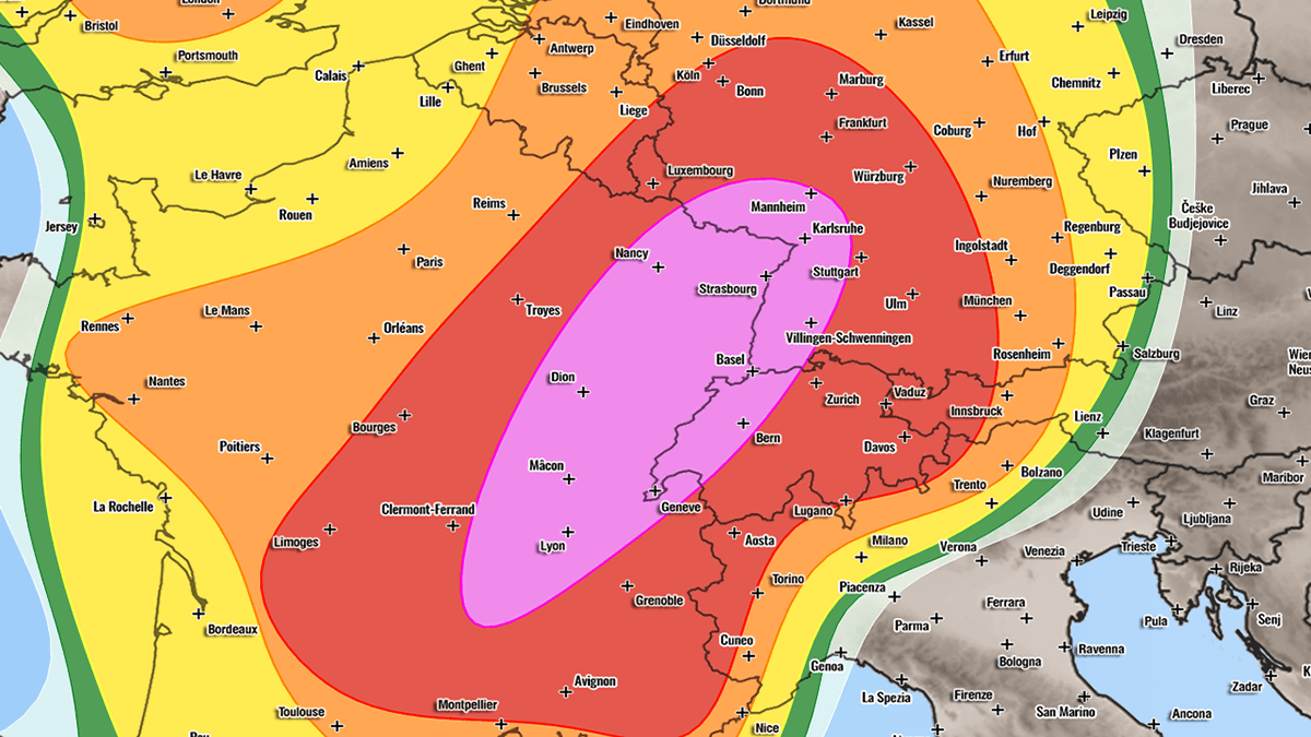
BRUSSELS / GENEVA / BERLIN — Meteorologists have issued a stern warning for millions of residents across Western and Central Europe as a potent, highly volatile atmospheric setup aligns to produce a significant, multi-day severe weather outbreak. Spanning from Thursday, August 27, through Friday night, August 28, 2026, the sweeping severe weather event is projected to unleash a cocktail of extreme hazards, including giant hail measuring up to 10 centimeters, destructive straight-line winds exceeding 120 km/h, torrential downpours capable of triggering flash floods, and a heightened risk of tornadoes.
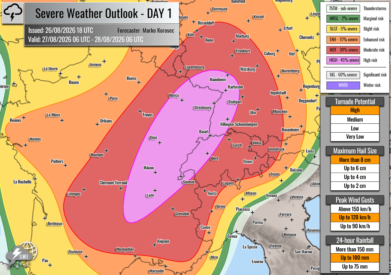
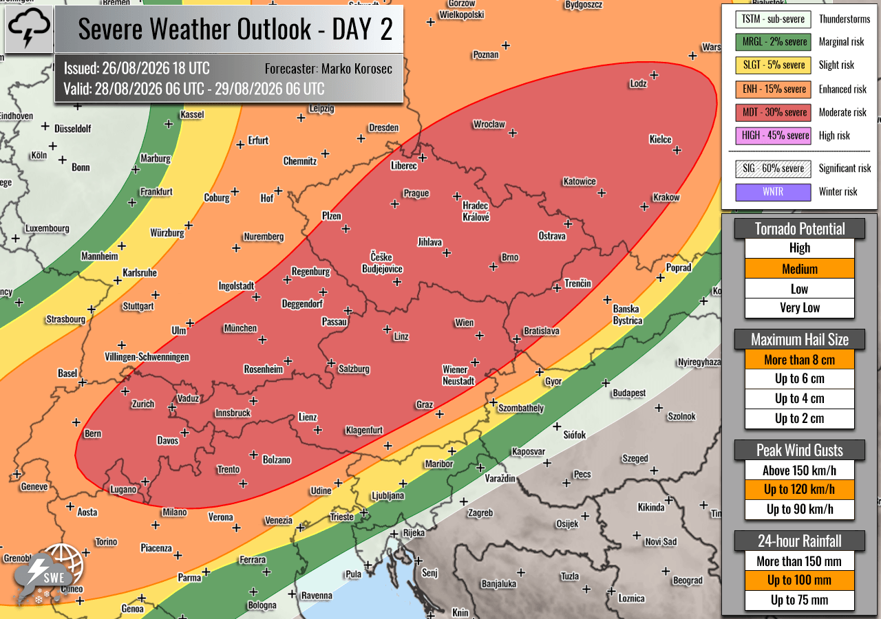
The alert, issued by Severe Weather Europe and spearheaded by forecaster Marko Korošec, has triggered rare HIGH and Moderate (MDT) risk levels. Emergency management agencies, civil protection services, and municipal authorities from eastern France to southwestern Poland are placing emergency responders on high alert as the continent braces for what could be one of the most intense convective outbreaks of the summer season.
1. Main Facts: The Anatomy of a Continental Convective Threat
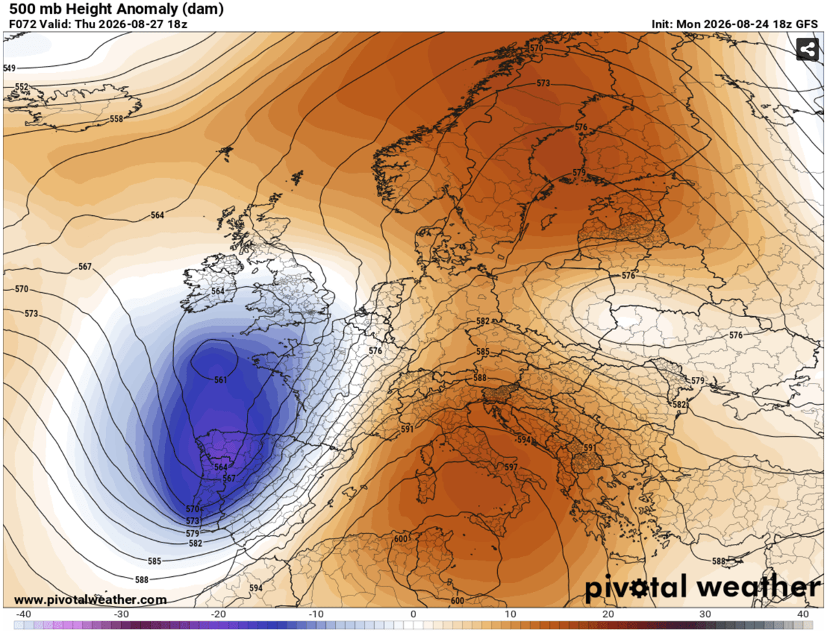
The driving force behind this impending meteorological upheaval is a classic, high-amplitude synoptic pattern. A large and exceptionally deep upper-level trough is rapidly digging into Western Europe. Simultaneously, a robust blocking high-pressure system remains entrenched over the Mediterranean region and the Balkans.
Trapped between these two gargantuan pressure systems, a powerful southwesterly jet stream is roaring across the western Mediterranean and into mainland Europe. This jet stream is injecting staggering amounts of warmth and moisture northward, interacting directly with the cool, unstable air brought by the approaching trough.
- Event Window: Thursday, August 27, 06:00 UTC through Saturday, August 29, 06:00 UTC.
- Primary Threat Zones: Eastern and southern France, western Switzerland, southwestern and central Germany, eastern Austria, the Czech Republic, and southwestern Poland.
- Core Hazards:
- Giant Hail: Stones ranging from 6 to 10 cm (or even larger) capable of heavily damaging vehicles, shattering solar panels, and injuring livestock and humans.
- Destructive Winds: Straight-line winds and potential bowing segments generating gusts in excess of 120 km/h.
- Tornadoes: Enhanced low-level shear and high storm-relative helicity favor tornadic supercells, particularly in the Rhône Valley.
- Flash Floods: Torrential rainfall rates threatening urban inundations and rapid river rises.
2. Chronology of the Outbreak: Day-by-Day Progression
Thursday, August 27: France, Switzerland, and Germany in the Crosshairs
The severe weather machine swings into high gear early Thursday afternoon. A potent frontal system will sweep eastward from Iberia and western France, colliding with an extremely unstable air mass fueled by ongoing extreme Mediterranean heatwaves.
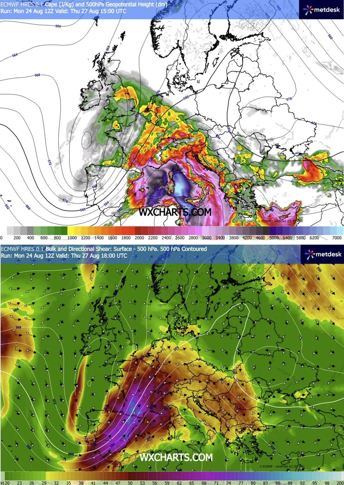
By midday Thursday, explosive thunderstorm initiation is anticipated over the rugged terrain of the Massif Central in France. As these storms march rapidly north-northeastward into the Rhône Valley, they will encounter extreme instability indices—with Mixed-Layer CAPE (Convective Available Potential Energy) values surging between 2,000 and 4,000+ J/kg.
- Afternoon: Isolated to discrete supercells will dominate the landscape. These individual storms present the greatest threat for very large to giant hail and intense, localized tornadic activity. The Rhône Valley is singled out as the primary focal point for tornadoes due to optimal low-level turning of the winds and high helicity.
- Evening & Night: As the upper-level forcing intensifies and the cold front pushes eastward, individual storms are forecast to rapidly congeal into massive convective clusters and squall lines. These clusters will barrel across the border into western Switzerland and southwestern Germany. The primary hazards transition toward widespread damaging straight-line winds and torrential, excessive rainfall.
- Secondary Threats: Northern extensions of the wave axis will clip the Benelux region and western Germany by late afternoon, bringing localized severe wind and heavy rain risks. Even southern England could see isolated severe storms during peak afternoon heating.
Friday, August 28: The Alps, Czech Republic, and Poland Take the Punch
As the primary weather system pivots eastward, the theater of severe weather shifts across the Alpine spine and into Central Europe.
- Early Afternoon: Daytime heating interacting with residual atmospheric moisture will spark isolated to scattered thunderstorms over the Alps. Initially, these will organize into intense multicells and supercells, threatening the high-altitude regions of eastern Switzerland and western Austria with large hail and flash flooding.
- Late Afternoon into Night: High-resolution numerical weather prediction models—including specialized WRF runs—indicate a dangerous evolution as these Alpine storms cascade northeastward. There is a growing consensus that the storms will organize into a massive Mesoscale Convective System (MCS) or a powerful squall line sweeping from southeastern Germany and northeastern Austria into the southwestern Czech Republic.
- Overnight Threat: If bowing segments within the squall line fully mature, a swath of destructive, hurricane-force straight-line winds exceeding 120 km/h could carve a path of structural damage across the Czech Republic and deep into southwestern Poland overnight.
3. Supporting Data and Meteorological Drivers
The severity of this upcoming outbreak is underscored by exceptional atmospheric parameters rarely seen simultaneously across such a broad geographic expanse:
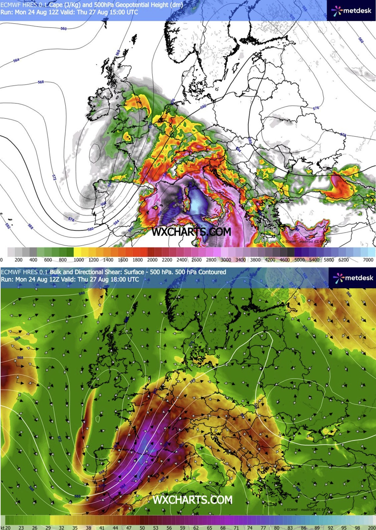
- Extreme Instability (CAPE): Surface dewpoints lifted from a superheated Mediterranean are yielding high instability values. MLCAPE readings of 2,000 to 4,000 J/kg over southeastern France represent immense buoyant energy, acting as rocket fuel for updrafts that can sustain large hailstones aloft for extended periods.
- Vertical Wind Shear: The juxtaposition of the deep trough and the Mediterranean blocking ridge creates a severe pressure and temperature gradient. This fuels a ferocious mid-level jet stream, providing intense speed and directional wind shear. This shear allows updrafts to rotate, transforming ordinary thunderstorms into long-lived, dangerous supercells.
- Low-Level Helicity: In localized corridors like the Rhône Valley, backed surface winds interacting with the robust southwesterly flow aloft will generate high storm-relative helicity, sharply increasing the probability of low-level mesocyclones and attendant tornado spins.
4. Official Responses and Civil Preparedness
In anticipation of the severe weather onslaught, national meteorological services across the affected countries have begun issuing orange and red weather warnings.
- France: Meteo-France has ramped up vigilance levels across east-central and southern departments. Civil protection units are advising citizens to secure loose outdoor objects, avoid non-essential travel during peak storm hours, and prepare for potential widespread power outages caused by lightning and violent wind gusts.
- Germany (DWD): The German Weather Service is closely monitoring the transition of severe clusters from France into southwestern and central Germany by Thursday night. Municipalities in Baden-Württemberg and Bavaria are opening emergency operations centers and urging event organizers to postpone or cancel outdoor gatherings.
- Switzerland & Austria: Alpine rescue and civil defense authorities have issued specific warnings for hikers and mountaineers. Flash flooding in narrow mountain valleys and sudden rockfalls triggered by heavy downpours pose severe risks to outdoor recreationists.
- Czech Republic and Poland: Emergency services are prepositioning equipment, clearing drainage systems to mitigate urban flash flooding, and alerting utility companies to prepare for substantial tree-fall damage over power grids during Friday night’s anticipated MCS progression.
5. Implications for Infrastructure, Agriculture, and Economics
The projected footprint of this severe weather outbreak covers some of Europe’s most densely populated and economically vital regions, carrying profound implications:
- Agricultural Devastation: Vineyards in France, orchards in Germany and Austria, and vast crop fields in Poland lie directly in the path of potential 10-cm hail swaths. Agricultural insurers are preparing for multi-million-euro claims as crops face near-total destruction in localized impact zones.
- Transportation Disruptions: Major European transit corridors—including the trans-Alpine freight routes, major motorways in Germany (Autobahns), and high-speed rail networks (TGV and ICE)—are expected to experience significant delays, cancellations, and infrastructure damage from fallen trees and flooded tracks.
- Power and Grid Stability: Widespread straight-line winds and intense cloud-to-ground lightning activity threaten regional electrical grids. Energy providers have placed repair crews on standby to manage anticipated localized blackouts.
As Europe stands on the brink of this severe weather event, authorities urge the public to closely monitor real-time radar updates, heed local emergency warnings, and seek sturdy shelter well before the storm fronts arrive.
