

Valid: August 27, 2026, 06:00 UTC – August 29, 2026, 06:00 UTC
Issued By: Severe Weather Europe
Lead Forecaster: Marko Korošec
Main Facts
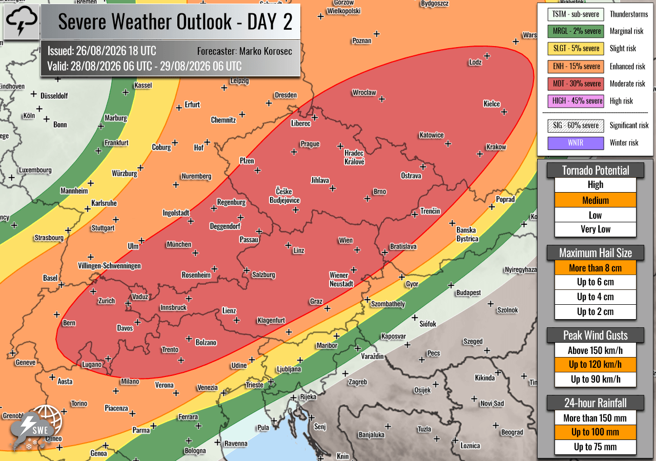
A volatile and potentially historic two-day severe weather outbreak is rapidly organizing across Western and Central Europe, threatening multiple nations with destructive hazards from Thursday through Friday night. Forecasters have issued rare HIGH and Moderate (MDT) risk levels—signaling an exceptionally dangerous meteorological setup—across regions stretching from eastern France and western Switzerland into southwestern Germany on Thursday, before shifting eastward into the Alps, the Czech Republic, and southwestern Poland on Friday.
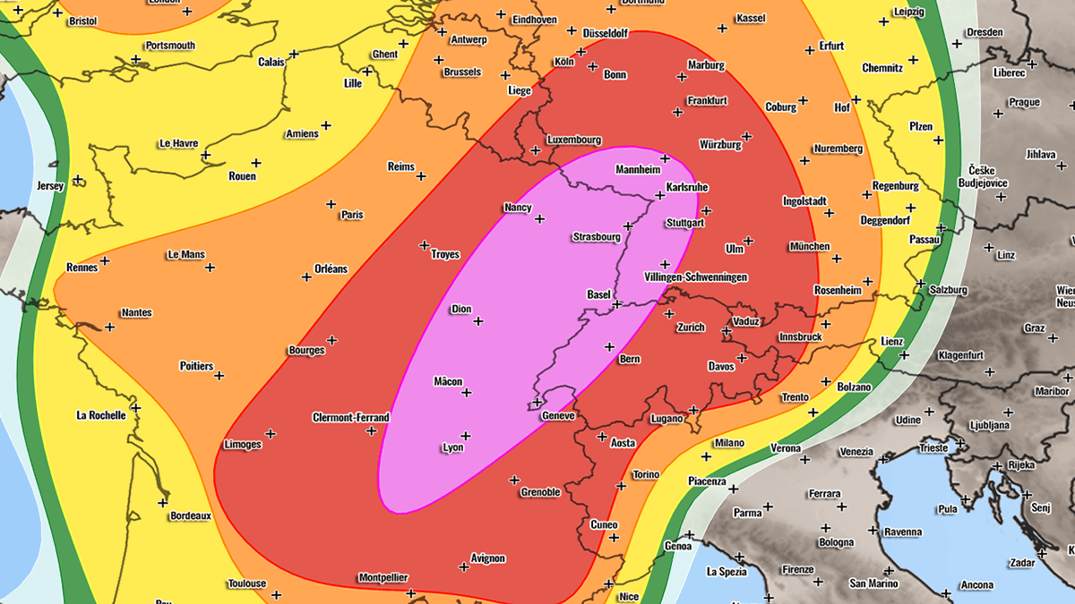
The primary threats associated with this vigorous convective system include:
- Giant Hail: Stones ranging between 6 cm and 10 cm (or even larger) capable of inflicting severe structural, vehicular, and agricultural damage.
- Destructive Straight-Line Winds: Severe gusts potentially exceeding 120 km/h (75 mph), capable of uprooting trees, downing power lines, and causing localized structural collapses.
- Tornadoes: Enhanced low-level shear and high storm-relative helicity create a favorable environment for tornadic supercells, particularly in parts of southeastern France.
- Flash Floods: Excessive, torrential rainfall rates threatening rapid inundation of urban areas, low-lying zones, and mountain passes.
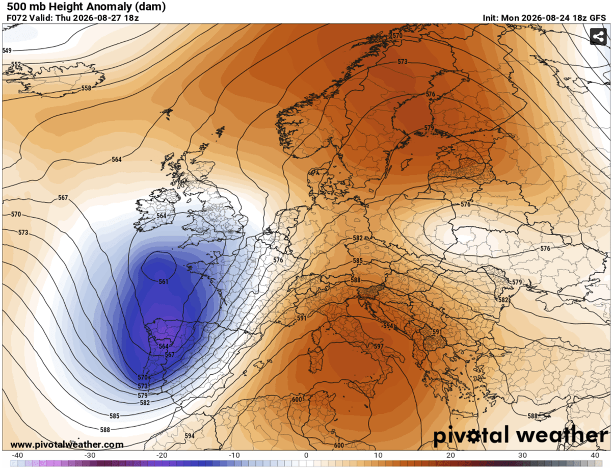
This severe weather episode is driven by the interaction of a deep, large-scale upper-level trough pushing out of the Iberian Peninsula and an entrenched blocking high-pressure system over the Mediterranean. This pressure and thermal contrast is fueling a powerful southwesterly jet stream, which in turn is advecting extreme heat and moisture from an ongoing Mediterranean heatwave into the heart of the continent.
Chronology of the Event
Thursday, August 27: The Threat Focuses on France, Switzerland, and Germany
The first wave of the outbreak commences around midday on Thursday, August 27.
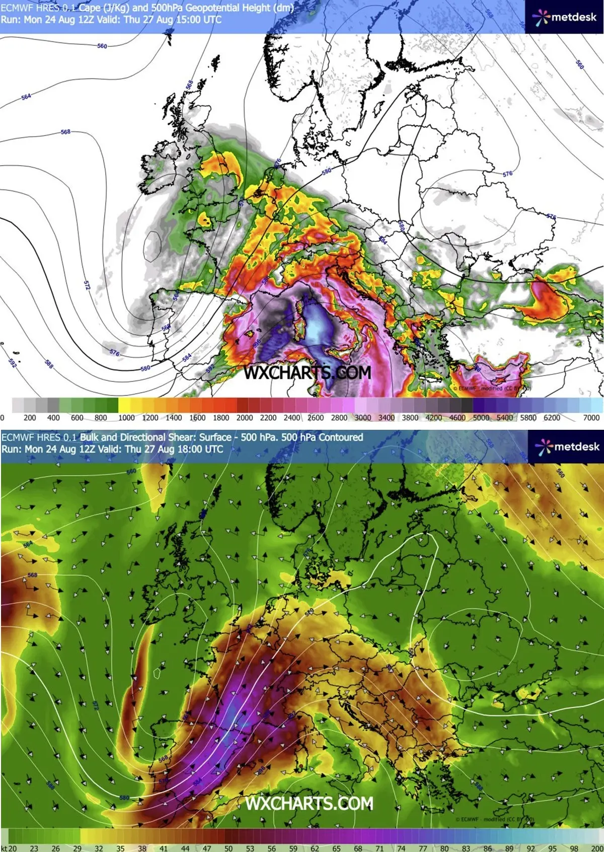
- Midday to Early Afternoon: Intense convective initiation is expected over the Massif Central in France, quickly spilling into the Rhône Valley. Driven by extreme low-level moisture and daytime heating, MLCAPE (Mixed-Layer Convective Available Potential Energy) values are projected to surge between 2,000 and 4,000+ J/kg over southeastern France.
- Late Afternoon: Isolated, highly volatile supercells will establish themselves as the primary storm mode. These storms will feature extreme updrafts capable of producing giant hail and localized tornadoes—with the Rhône Valley identified as the zone of maximum tornado threat due to optimal low-level wind shear.
- Evening: As steering winds aloft accelerate, individual supercells will race east-northeastward, crossing the border into western Switzerland and southwestern Germany. By nightfall, these storms are forecast to aggregate into larger clusters and Mesoscale Convective Systems (MCS), posing widespread risks for damaging straight-line winds, torrential downpours, and frequent cloud-to-ground lightning.
- Secondary Northward Threat: Simultaneously, a secondary axis of storm development will push toward the Benelux union and western Germany, bringing risks of severe winds, localized flooding, and isolated tornadoes. Even southern England could experience isolated severe storms during peak afternoon heating as the wave axis crosses.
Friday, August 28: The Danger Shifts to the Alps, Czech Republic, and Poland
By Friday morning, the upper-level dynamic forcing and cold front will advance eastward, pivoting the primary severe threat zone toward Central Europe.
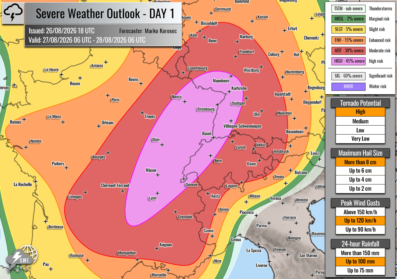
- Early Afternoon: Isolated to scattered thunderstorms will initiate over the rugged terrain of the Alps, fueled by remaining instability and strong mid-level shear. Initial storm structures will favor intense multicells and discrete supercells.
- Late Afternoon to Evening: A critical phase of the outbreak unfolds as storms consolidate into one or two massive convective systems. High-resolution numerical models indicate a severe bow-echo signature may develop, sweeping out of southeastern Germany and northeastern Austria into the southwestern Czech Republic.
- Overnight: The threat axis pushes into southwestern Poland. Meteorologists warn that if the bowing segments organize efficiently, widespread straight-line wind gusts exceeding 120 km/h could carve a path of destruction across the region, accompanied by heavy downpours and localized flash flooding.
Supporting Meteorological Data and Synoptic Overview
To understand the severity of this upcoming event, meteorologists look to the broader synoptic-scale pattern currently dominating the European continent.
The Upper-Level Setup
A robust upper-level blocking ridge is firmly established over the Mediterranean, Central Europe, and the Balkans. Concurrently, a deep, energetic trough is cutting across western Iberia. This configuration creates an exceptionally tight pressure and temperature gradient.
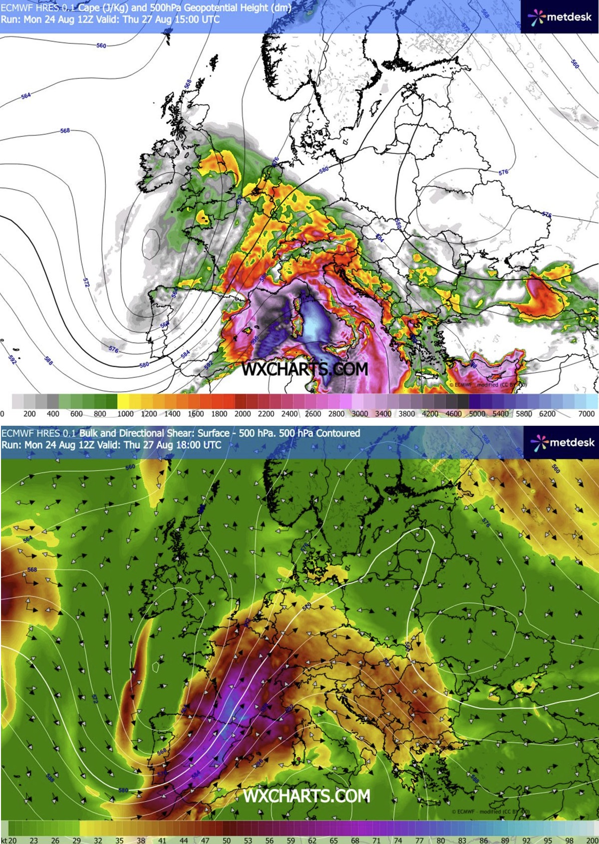
Wedged between these two massive pressure systems is a potent southwesterly jet stream that extends from eastern Spain, across the western Mediterranean, and directly into southern and eastern France. This jet stream provides the vital dynamic ingredient: intense vertical wind shear. Wind shear allows updrafts within thunderstorms to tilt, separating warm updrafts from rain-cooled downdrafts, thereby allowing storms to sustain themselves for hours and grow exceptionally violent.
[Western Iberian Trough] <--- (Pressure Gradient) ---> [Mediterranean Blocking Ridge]
                                                                /
           ---> [Powerful Southwesterly Jet Stream] <----------/
                         |
           (Advects Heat & Extreme Moisture)
                         |
                         v
     [Explosive Supercell & MCS Development (Thu-Fri)]
Thermodynamic Instability and Low-Level Moisture
The ongoing, prolonged heatwave across the Mediterranean basin has primed the lower troposphere with record-level humidity and heat. As the advancing frontal system sweeps east, it taps into this reservoir of moisture, yielding extreme instability indices.
- MLCAPE Values: Projected to reach 2,000 to 4,000 J/kg over parts of southeastern France. Such values indicate an atmosphere packed with buoyant energy, capable of supporting explosive cloud growth and towering cumulonimbus clouds that reach well into the upper troposphere.
- Dewpoints: Exceptionally high dewpoints will maintain high equivalent potential temperature ($theta_e$) values, feeding the storms with continuous fuel even after sunset on Thursday.
- Helicity: High storm-relative helicity values—particularly in the lowest 1 kilometer of the atmosphere—will generate the rotational components necessary for supercells and potential tornadic activity.
Official Responses, Advisories, and Warnings
In response to the high-risk outputs generated by Severe Weather Europe and cooperating forecasting agencies (utilizing models from Meteoadriatic, Wxcharts, and PivotalWeather), civil protection authorities across the affected countries are mobilizing:
- France: Meteo-France and local prefectures are expected to issue orange and red weather alerts for regions spanning the Massif Central and the Rhône Valley. Residents have been urged to secure outdoor property, move vehicles away from large trees, and stay informed via official channels. Emergency services have placed rescue units on standby for potential flash flooding and structural damage response.
- Germany: The Deutscher Wetterdienst (DWD) is closely monitoring the transition of storms into southwestern and central Germany. Warnings are being prepared for rapid-onset squall lines capable of producing hurricane-force wind gusts.
- Switzerland, Austria, and the Czech Republic: Alpine authorities have issued warnings regarding flash floods and mudslides, particularly in narrow river valleys and steep terrain where torrential rainfall can trigger sudden hydrological events. Hikers and campers in high-altitude areas have been advised to evacuate or seek secure indoor shelter before Thursday afternoon.
- Poland: Emergency management teams in southwestern Poland are reviewing disaster response protocols ahead of the late-Friday and overnight threats, focusing on potential power grid failures and tree clearings along major transport corridors.
Implications for Infrastructure, Agriculture, and Daily Life
A severe weather outbreak of this magnitude carries profound socio-economic and environmental implications:
- Transport and Aviation: Major European transit corridors—including key autobahns in Germany, high-speed rail networks in France (TGV), and vital Alpine transit passes—face significant disruptions. Airports situated in the path of the convective clusters (such as Geneva, Lyon, Munich, and Prague) may experience ground stops, delayed flights, and hazardous wind shear during takeoff and landing phases.
- Agriculture: Vineyards, orchards, and crop fields in the path of the projected 6–10 cm hail swaths risk catastrophic devastation. Agricultural insurance providers are preparing for heavy claims, particularly in famed wine-producing regions of France and southern Germany.
- Power Grids: Widespread straight-line winds and cloud-to-ground lightning pose a severe threat to electrical transmission infrastructure. Power utilities are positioning repair crews and maintenance vehicles near high-risk zones to ensure rapid restoration following the storms.
- Urban Safety: Flash flooding in metropolitan areas with high amounts of impermeable concrete surfaces could overwhelm municipal drainage systems, leading to stranded motorists in underpasses and flooded basements. Public authorities strongly advise citizens to avoid driving through standing water and to remain indoors during the peak of the storms.
