

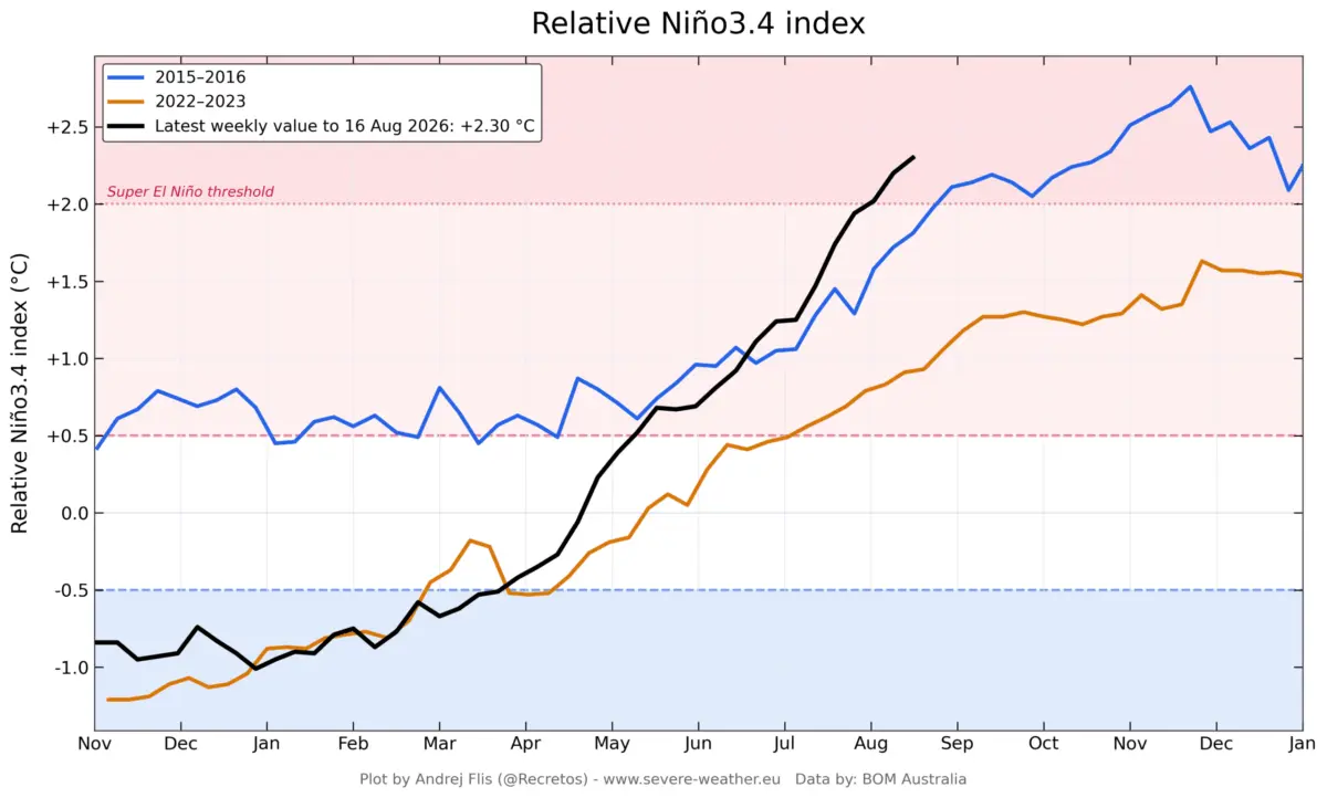
As the Northern Hemisphere transitions into the meteorological fall of 2026, long-range weather models are locking onto a formidable global climate driver: a rapidly intensifying Super El Niño. Current forecasts indicate an unusually evolved atmospheric response, with computer models pointing toward a record-strong warm phase in the equatorial Pacific. This tropical powerhouse is already warping global pressure gradients, setting the stage for an abnormally advanced, winter-like weather regime across North America and Europe well ahead of schedule.

Meteorologists and climatologists analyzing data from NOAA, the European Centre for Medium-Range Weather Forecasts (ECMWF), and the North American Multi-Model Ensemble (NMME) note that this event is tracking significantly ahead of historical benchmarks, such as the legendary 2015–2016 El Niño event. With ocean surface and subsurface temperature anomalies shattering expectations, the upcoming Fall and Winter 2026/2027 seasons promise profound disruptions to standard seasonal weather tracks.
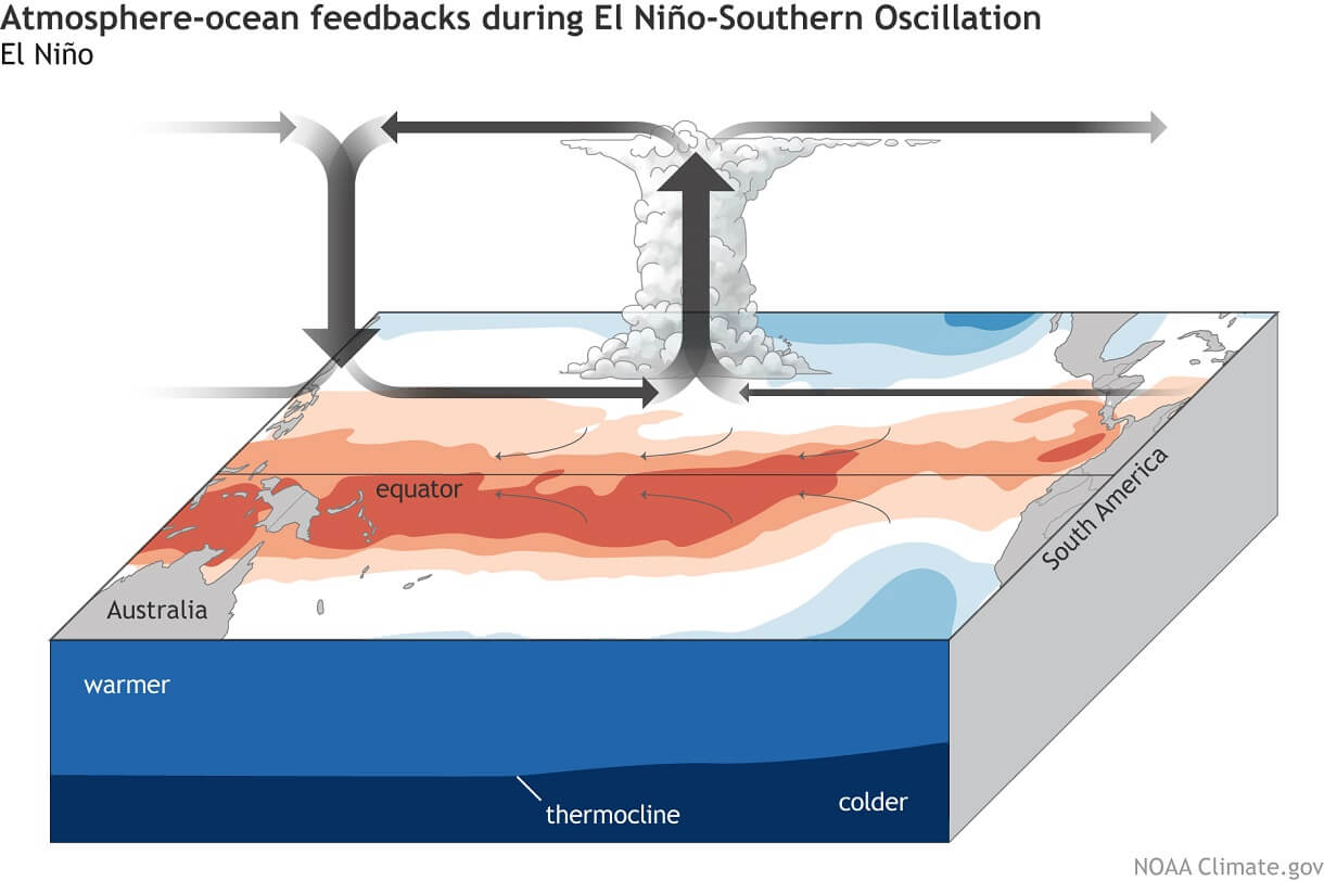
Main Facts: The Anatomy of the 2026 Super El Niño
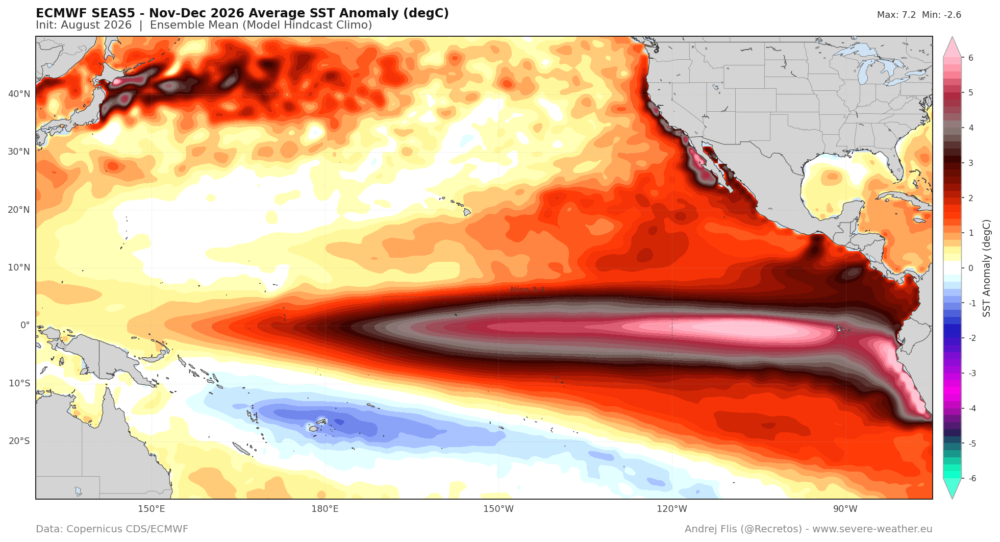
The core driver of the incoming seasonal shift is a massive build-up of thermal energy in the tropical Pacific Ocean. To be classified as a Super El Niño, seasonal sea surface temperature (SST) anomalies in the main ENSO (El Niño-Southern Oscillation) regions must sustain values above the +2.0°C threshold. Current readings have not only cleared this hurdle but are trending toward peaks that could challenge historical records.
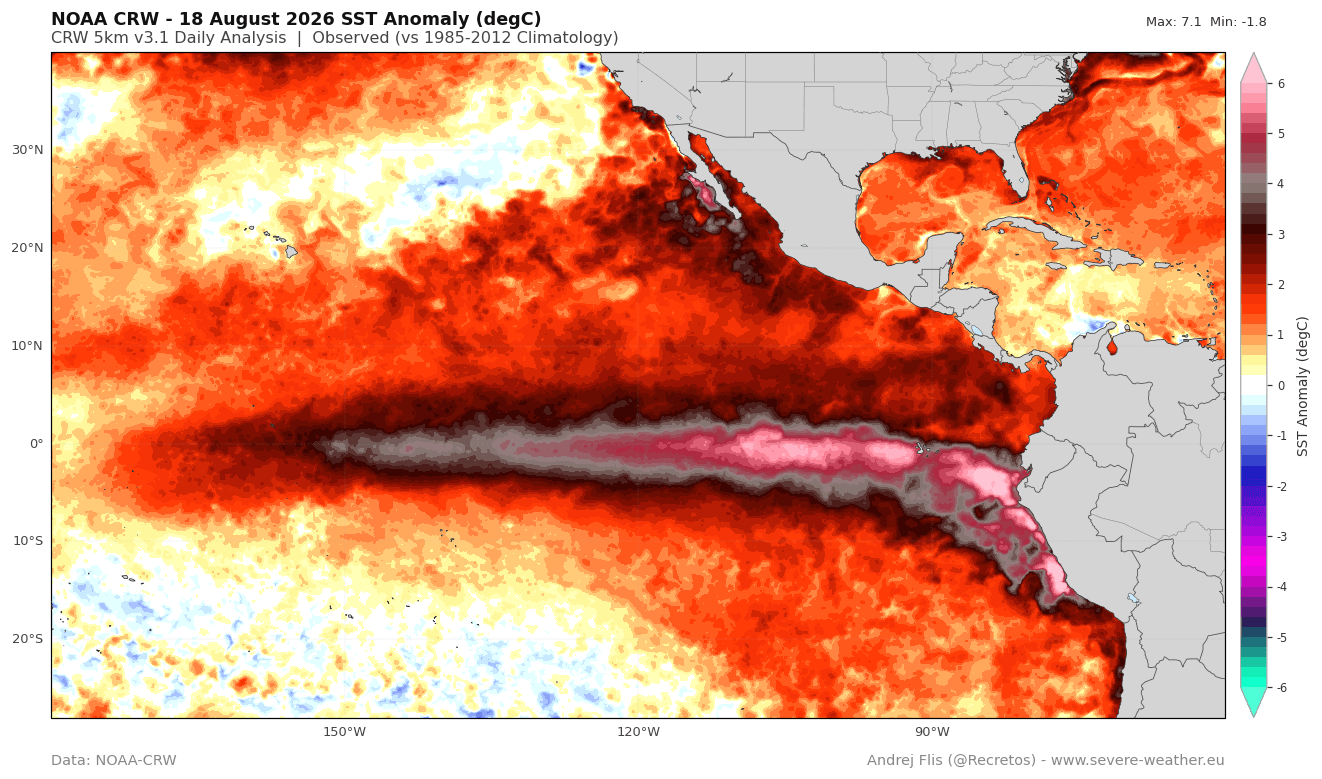
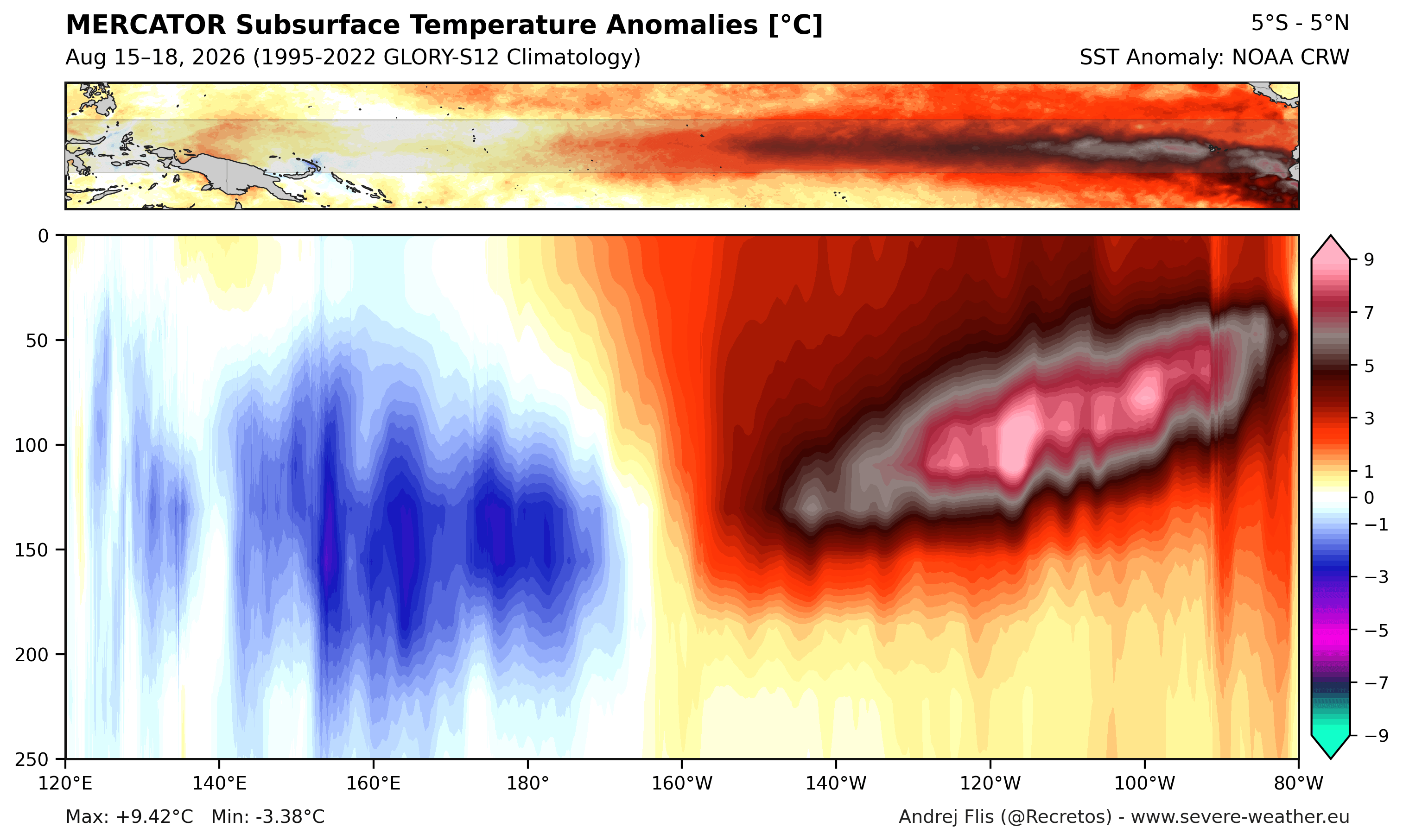
- Unprecedented Subsurface Warmth: NOAA-CRW data reveals peak surface anomalies exceeding 7°C (12.5°F) above normal in localized zones, while subsurface analyses show a powerful downwelling Kelvin Wave in the upper 250 meters (800 feet) of the tropical Pacific. Peak subsurface anomalies are registering over 9°C (16°F) above normal.
- Rapid Chronology: Powered by persistent westerly surface winds pushing eastward, the current Kelvin wave has developed at an accelerated pace. August temperature anomaly values for this cycle have already surpassed those recorded in late October during the 2015 Super El Niño event.
- Atmospheric Bridge and Walker Circulation: The vast pool of warm water is fundamentally altering global atmospheric circulation. Rising air over the central and eastern Pacific generates increased precipitation and lower surface pressures, while descending air over the western Pacific fosters stable, high-pressure conditions. This creates the classic Walker Circulation bridge that translates tropical heat into worldwide pressure anomalies.
Chronology and Evolution: From Summer Surges to Fall Anomalies
The developmental timeline of the 2026/2027 El Niño has caught long-range forecasters by surprise due to its velocity.
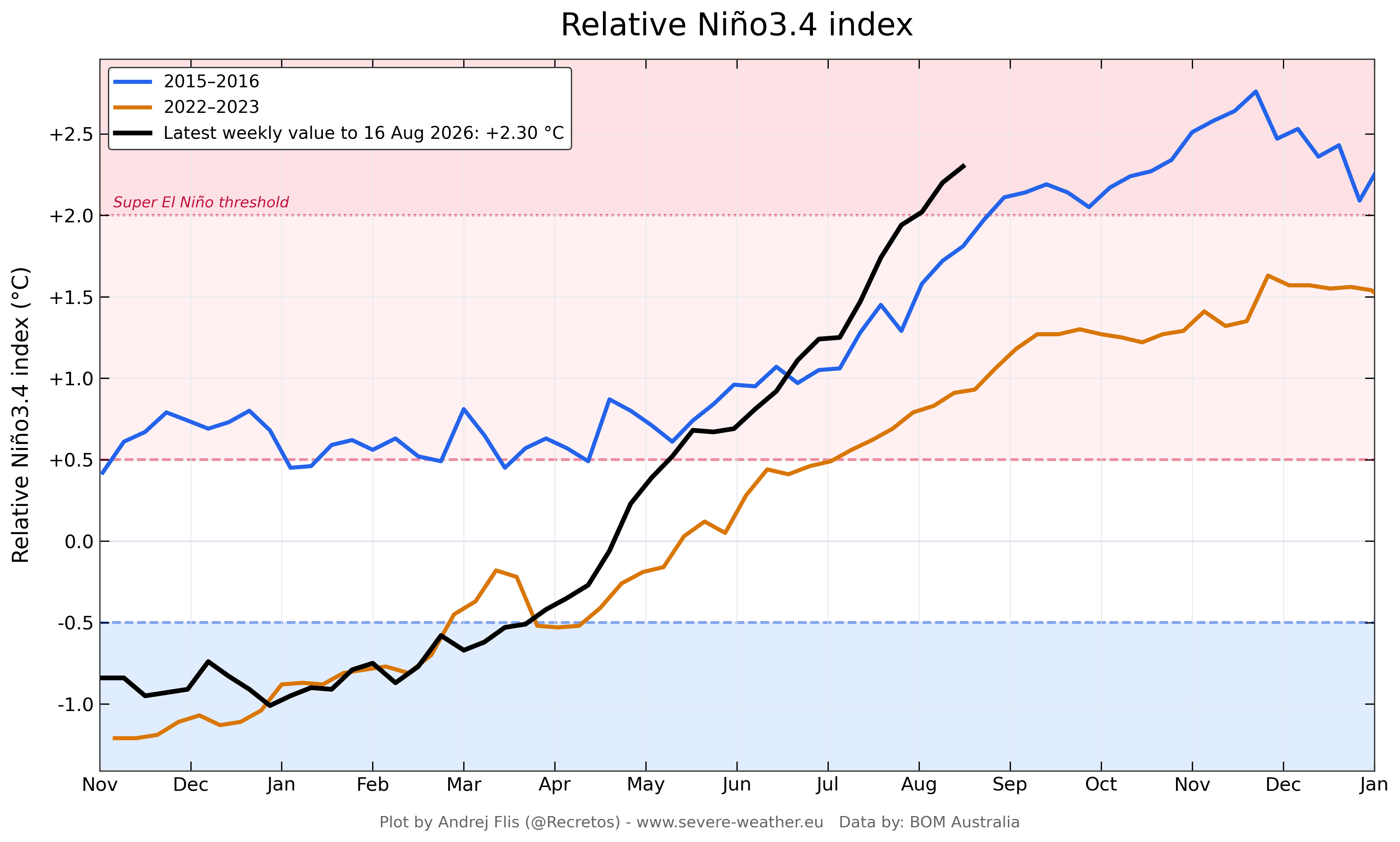
Spring to Summer 2026: Rapid Acceleration
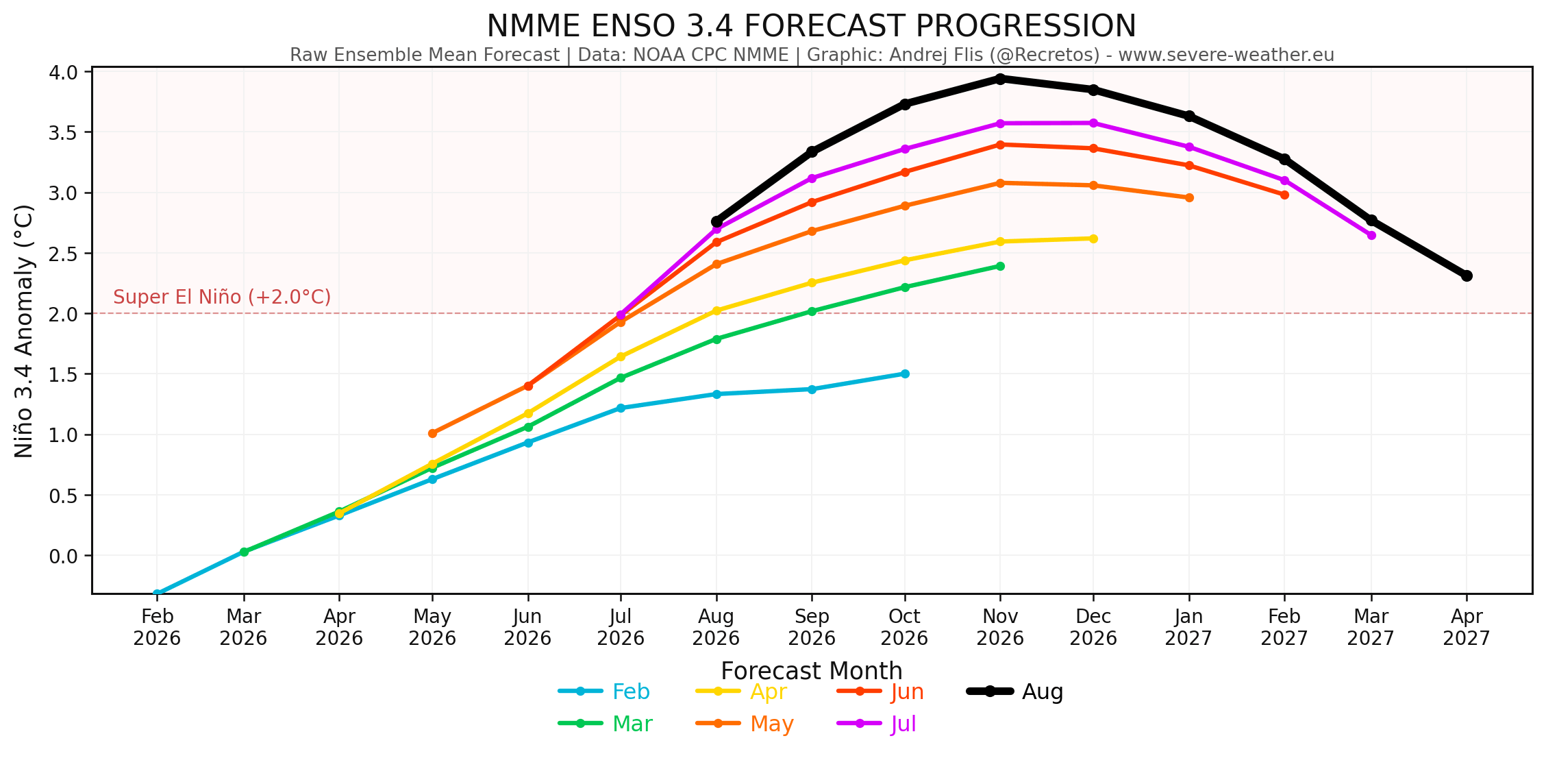
Throughout the spring months, multi-model runs—particularly the NMME—trended consistently upward. By mid-summer, subsurface Kelvin wave activity had consolidated into a massive warm-water core. Unlike typical ENSO developments that experience gradual maturation, the 2026 event vaulted past critical thresholds months ahead of its traditional seasonal peak, which typically occurs in late autumn or early winter.
Fall 2026: An Accelerated Winter Transition
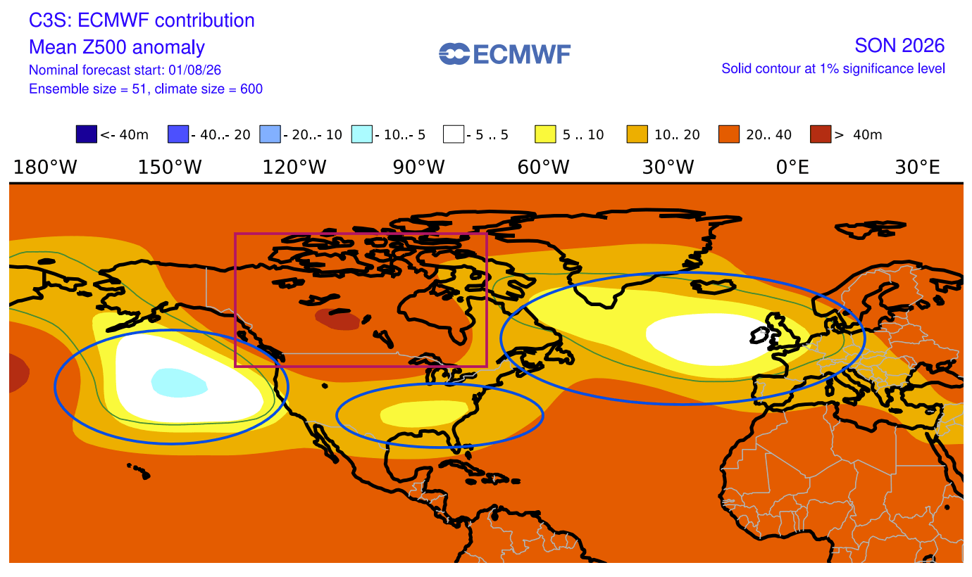
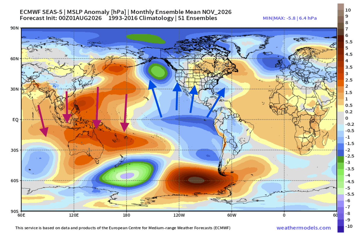
Normally, the transition from fall to winter features a gradual evolution of jet stream alignments. However, because the ocean forcing is so intense, the atmosphere is skipping transitional phases. Recent ECMWF global pressure anomaly forecasts for September through November 2026 reveal a split-flow setup characterized by:
- A strong high-pressure blocking anomaly established over Canada and the northern United States.
- Persistently lower pressures over the North Pacific.
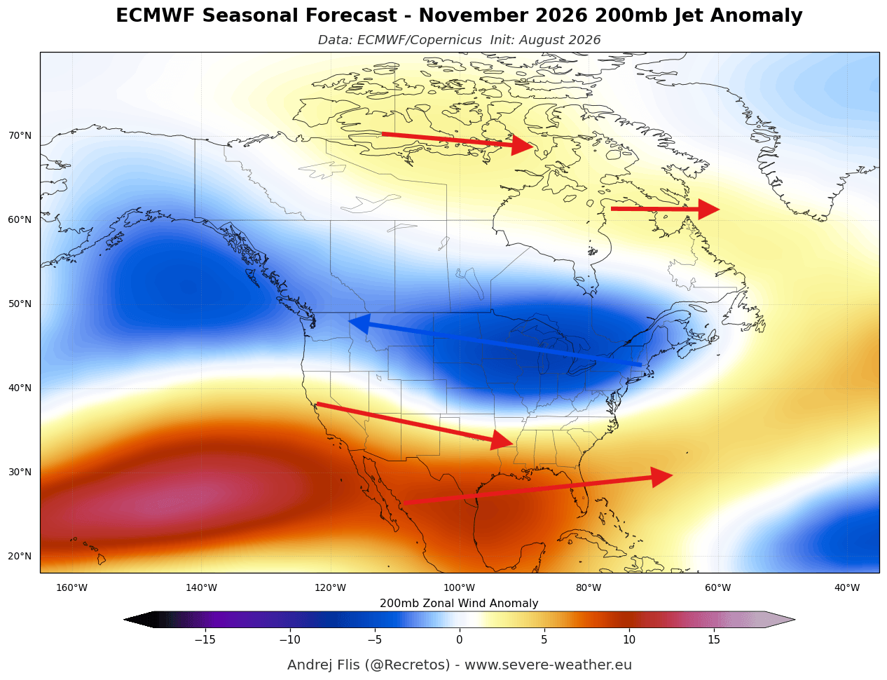
- An active, moisture-laden southern storm track cutting across the United States.
This configuration mirrors a mature, mid-winter El Niño pattern rather than a standard autumnal setup, dictating unusual temperature and precipitation anomalies across both continents.
Supporting Data: Regional Breakdown of the Fall 2026 Forecast
Evaluating the latest multi-model ensembles yields a clear picture of what North America and Europe can expect as the calendar turns toward late 2026.
North America: Warm Ridges and Southern Storms
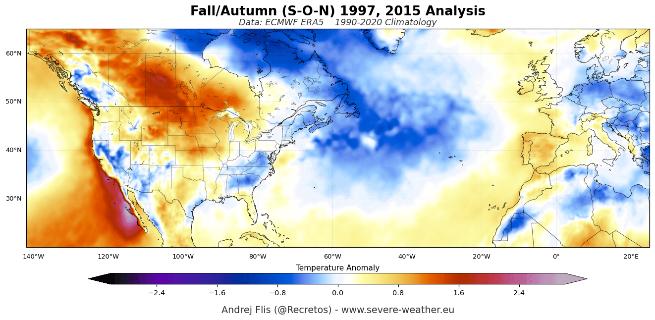
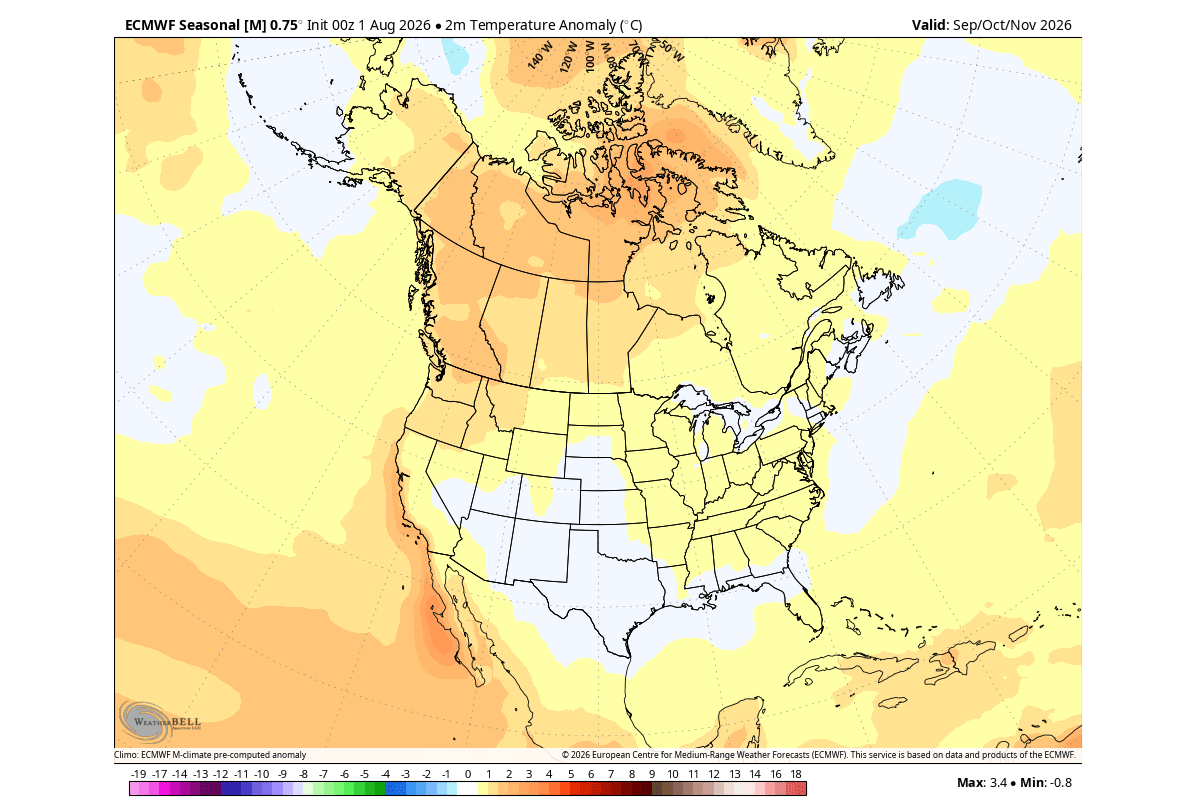
- Temperatures: Under the dominant Canadian high-pressure ridge, above-normal surface temperatures are forecast across western and central Canada, as well as the northern tier of the United States. Conversely, the active southern jet stream will help keep temperatures closer to normal across the southern U.S.
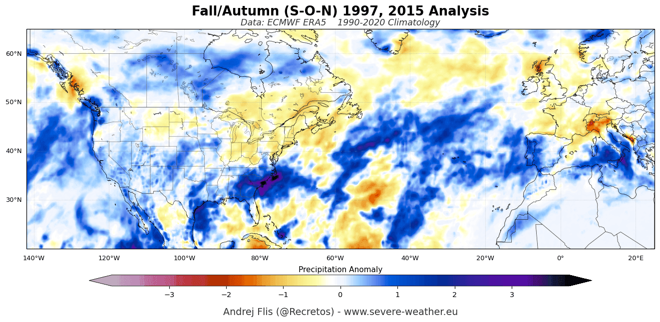
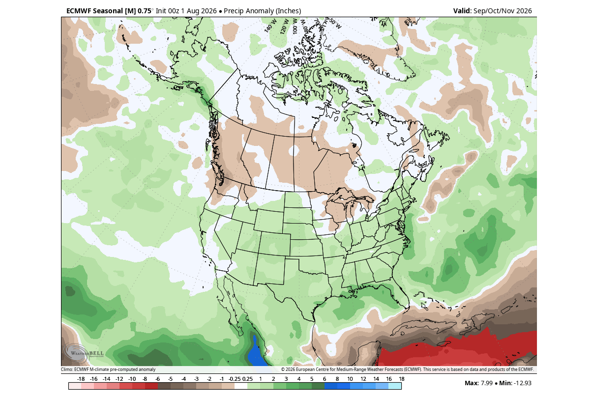
- Precipitation and Snowfall: A classic El Niño signature is taking shape in rainfall metrics. Increased precipitation is projected across the southern and southeastern United States, driven by a supercharged subtropical jet stream pulling moisture from the Pacific. Meanwhile, the Pacific Northwest and parts of southern Canada face drier-than-average conditions.
- November Snowfall Dynamics: While the Canadian high-pressure anomaly generally suppresses early snow cover, late-Fall snowfall anomalies point toward localized above-average accumulations across the U.S. Northern Plains and the higher elevations of west Texas, fueled by vigorous southern storm systems interacting with cold air boundaries.
Europe: Atlantic Influence and Milder Flow
- Temperatures: Across the Atlantic, a corresponding low-pressure area near northwestern Europe is driving a robust westerly and southwesterly flow. This pattern will pump mild, maritime air into the continent, leading to warmer-than-normal surface temperatures, particularly in central, western, and southeastern regions.
- Precipitation and Snowfall: The active Atlantic storm track will bring above-normal rainfall to much of mainland Europe, especially across western and southern zones. Because of the milder thermal profile, the early snow season is projected to experience a slow start with below-average accumulations, with the notable exception of high-altitude zones such as the western Alps.
Official Outlooks and Multi-Model Consensus
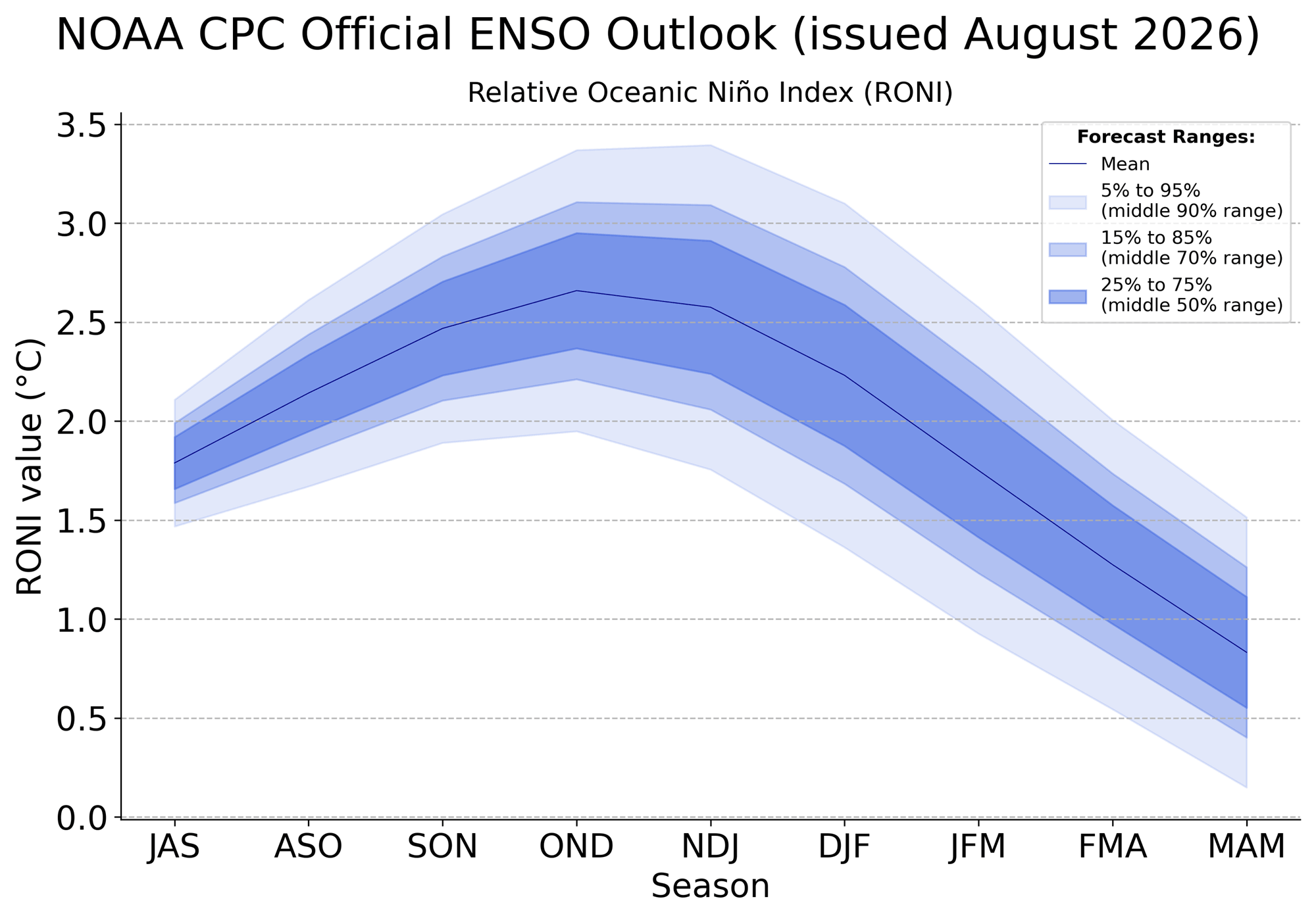
Official seasonal outlooks issued by the NOAA Climate Prediction Center (CPC) and the North American Multi-Model Ensemble align closely with European modeling.
The official NOAA CPC ENSO outlook projects a strong seasonal peak comfortably exceeding the +2.5°C threshold. Meanwhile, consecutive runs of the NMME system have scaled their projections higher, with some calculations pointing toward peak anomaly values nearing +4.0°C in the core ENSO regions.
These forecasts classify the event as an Eastern Pacific (EP) based El Niño. Scientific studies emphasize that EP events trigger a much more pronounced North Pacific pressure response than Central Pacific (CP) events, maximizing moisture transport into the southern United States and intensifying global teleconnections.
Implications for Winter 2026/2027: The Polar Vortex Risk
Looking ahead to December 2026 through February 2027, the atmospheric anomalies observed in fall are expected to amplify significantly rather than dissipate.
Mid-to-Late Winter Pressure Patterns
GFS/CFSv2 and ECMWF winter outlooks suggest that the Canadian high-pressure blocking anomaly will act as a massive atmospheric boulder, persistently deflecting the polar jet stream. This setup strongly favors a mild winter across Canada and the northern U.S., contrasted by a high-frequency storm track across the southern, central, and eastern United States.
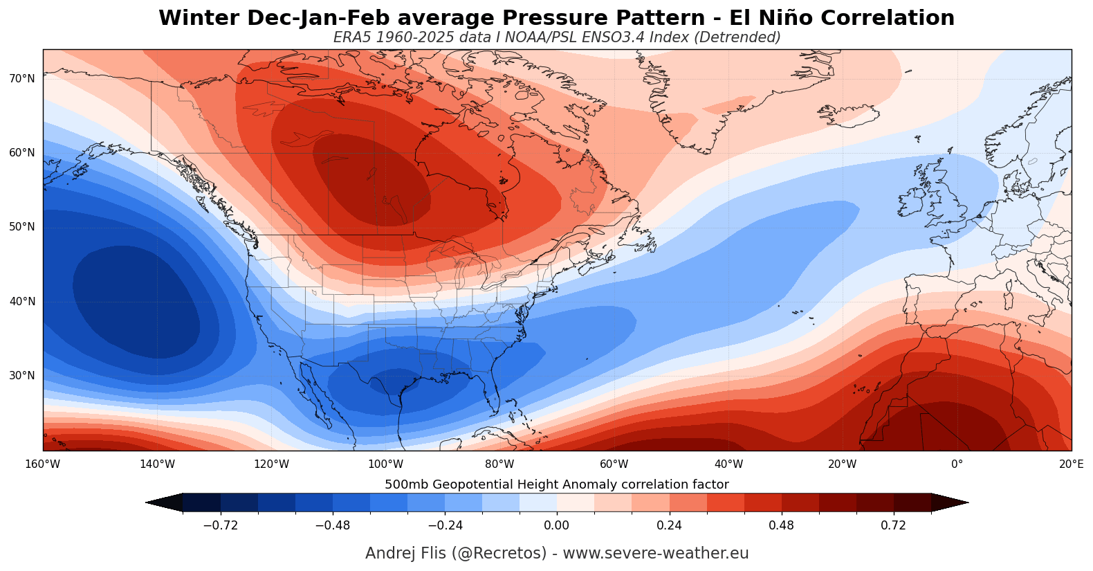
The Stratospheric Connection: Polar Vortex Disruptions
Perhaps the most critical implication of a Super El Niño during deep winter is its relationship with the Polar Vortex. Spanning from the troposphere up into the stratosphere (over 50 km / 31 miles high), the Polar Vortex dictates the containment of bitter Arctic air.
Historical climatology indicates that El Niño winters feature an elevated statistical tendency toward Sudden Stratospheric Warming (SSW) events and Polar Vortex disruptions. The intense thermal and wave energy radiating upward from the troposphere—specifically driven by amplified North Pacific and North American pressure patterns—acts to destabilize the stratospheric vortex.
- The January Risk: Both ECMWF and UKMO stratospheric forecasts for late December and January indicate an unusual deceleration of zonal stratospheric winds.
- The Result: A weakened or disrupted Polar Vortex loses its ability to bottle up Arctic air. While El Niño winters on average skew milder across North America, a mid-winter Polar Vortex collapse dramatically increases the risk of severe, high-impact cold air outbreaks spilling down into the mid-latitudes.
Conclusion
The Fall 2026 and Winter 2026/2027 seasons are shaping up to be heavily dictated by a historic Super El Niño event. With ocean temperatures surging into record territory and atmospheric models displaying advanced, winter-like configurations months ahead of schedule, residents across North America and Europe must prepare for a volatile cold season.
While southern regions of the U.S. and parts of Europe brace for heightened storminess and moisture, the overarching threat of a destabilized Polar Vortex in mid-winter serves as a reminder that even the warmest El Niño phases can harbor severe, disruptive cold outbreaks. Meteorologists will continue monitoring these teleconnections closely as the ocean-atmosphere feedback loop reaches its peak.
