

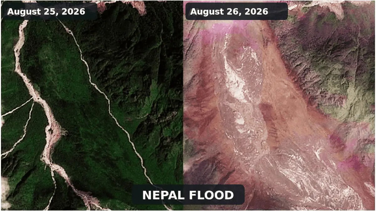
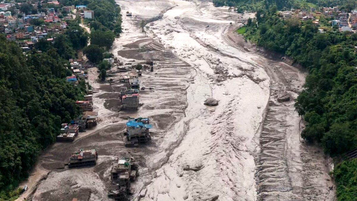
August 26, 2026 — A violent cataclysm tore through the transboundary Bhote Koshi and Trishuli river systems, unleashing an unstoppable wall of water, mud, and house-sized boulders that devastated settlements, roadways, and critical infrastructure across northern Nepal and southern Tibet. Driven by an unprecedented high-altitude mass movement, the disaster caught communities off guard, wiping out bridges and hydropower installations in minutes.
While early reports focused on conflicting seismic indicators and feared Glacial Lake Outburst Floods (GLOFs), subsequent satellite telemetry, geological forensics, and seismological audits have revealed a far more complex and hazardous geophysical cascade: an ice-and-rock avalanche that temporarily dammed a narrow Himalayan valley before violently bursting downstream.
Main Facts: The Anatomy of the August 26 Disaster
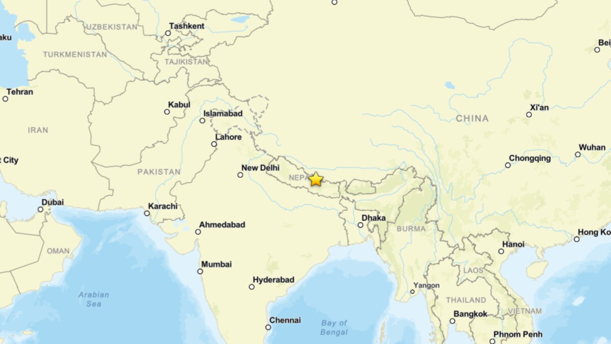
The catastrophic flash flood struck on the morning of August 26, crossing international boundaries from Tibet into Nepal’s Rasuwa district. Initial casualty metrics compiled by the Associated Press reported at least 160 fatalities across Nepal and China, with hundreds of locals, migrant workers, and tourists still listed as missing. Due to obliterated roadways, severed communication lines, and blocked valleys, disaster management agencies warn that these figures are likely severe underestimates.
The primary event originated in the upper Lhende Khola, a steep tributary of the Bhote Koshi near the border. According to assessments by the International Center for Integrated Mountain Development (ICIMOD) utilizing Planet Labs satellite imagery, a massive slope failure on a glacierised peak released a destructive combination of bedrock, glacial ice, and snow.
Key technical parameters defining the event include:
- The Origin Point: The upper Lhende Khola catchment, characterized by steep, retreating glacier slopes and periglacial rock walls.
- The Surge Velocity: Hydrological stations recorded an extraordinary nine-meter (30-foot) vertical spike in river levels along the Trishuli River in a span of just 30 minutes.
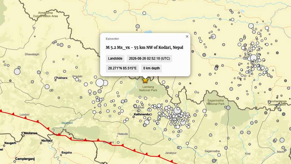
- The Seismic Profile: A seismic signal initially logged by regional monitors as a magnitude 4.4 earthquake was later reclassified by the U.S. Geological Survey (USGS) as a magnitude 5.2 landslide. This confirmed that the seismic ground motion was generated by the catastrophic collapse itself, rather than acting as its tectonic trigger.
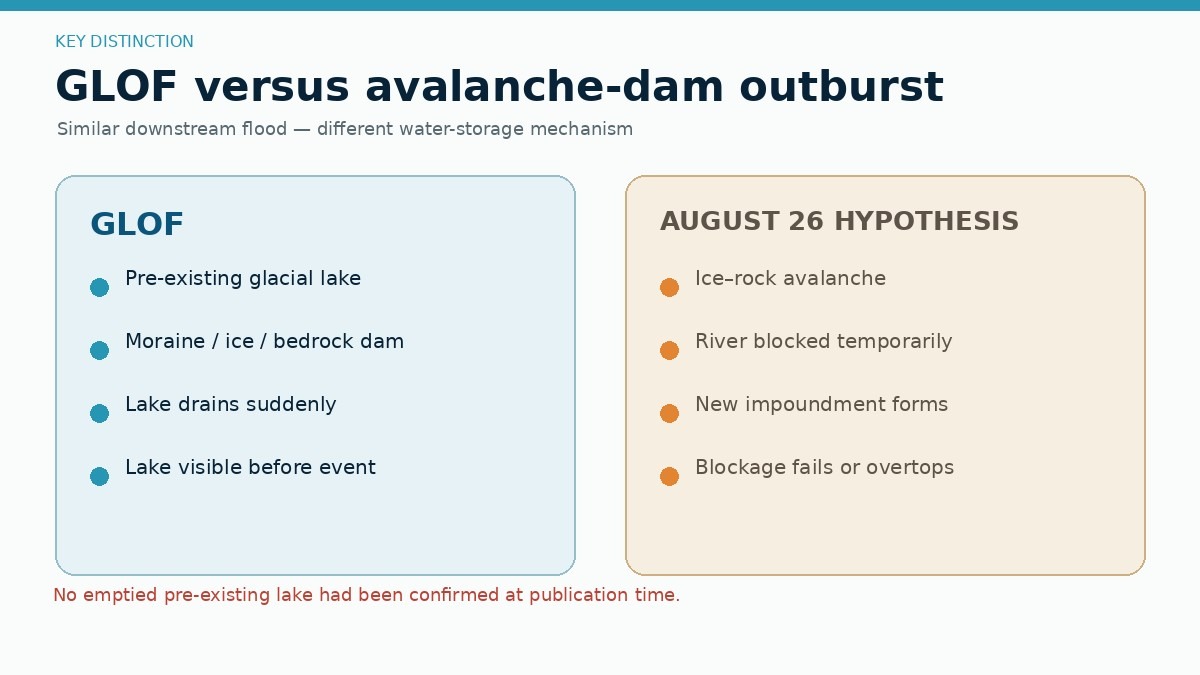
- The Mechanism: An ice-and-rock avalanche-induced landslide-dam outburst flood, distinct from a traditional GLOF because no pre-existing, permanent glacial lake was the primary reservoir.
Chronology of Events: How the Crisis Unfolded
Reconstructing the disaster requires tracing a rapid multi-stage natural chain reaction that evolved over seconds, hours, and days.
Phase 1: Slope Failure and Seismic Shock (Pre-Dawn to Morning, August 26)
Decades of thermal stress, permafrost degradation, and internal ice fracturing brought a steep, glacier-clad rock wall in the upper Lhende Khola close to its mechanical breaking point. On August 26, the slope lost its structural integrity. A massive volume of ice and fractured bedrock detached simultaneously. As millions of tons of material plunged downslope, it generated seismic waves that registered across regional networks, initially trickling into global monitoring centers as a shallow tectonic earthquake.
Phase 2: Valley Obstruction and Natural Damming (Minutes)
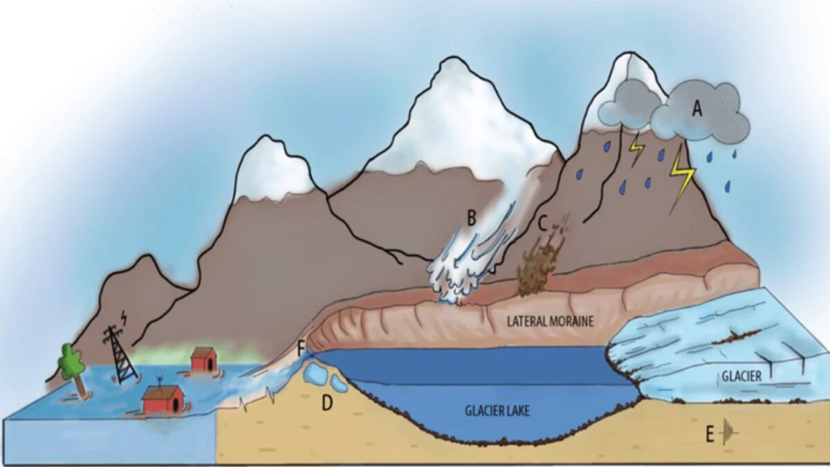
The high-speed ice-and-rock avalanche thundered down the steep mountain flanks and slammed directly into the narrow channel of the Lhende Khola. The avalanche debris—a chaotic slurry of shattered ice, boulders, and pulverized earth—acted as an instantaneous, highly permeable natural dam. This barrier choked the river valley, halting the downstream flow of water and creating a volatile, rapidly filling temporary lake behind the debris mass.
Phase 3: The Dam Breach and Debris Surge (Mid-Day, August 26)
Unable to withstand the immense hydrostatic pressure of the impounded water, the unstable boulder-and-ice dam suffered catastrophic partial failure. The sudden release of both the trapped water and the pulverized dam material created a hyper-concentrated debris flow. Traveling down the narrow gorges of the Bhote Koshi and Trishuli river systems, the flash flood scoured riverbeds, entrained additional sediment, and multiplied its destructive energy, hitting downstream Nepalese settlements with devastating momentum.
Supporting Data: Scientific Forensics and Analogous Disasters
To understand the mechanics of the August 26 catastrophe, international geomorphologists and cryospheric scientists immediately drew comparisons to recent high-mountain failures in the European Alps.
The Marmolada Precedent (July 2022)
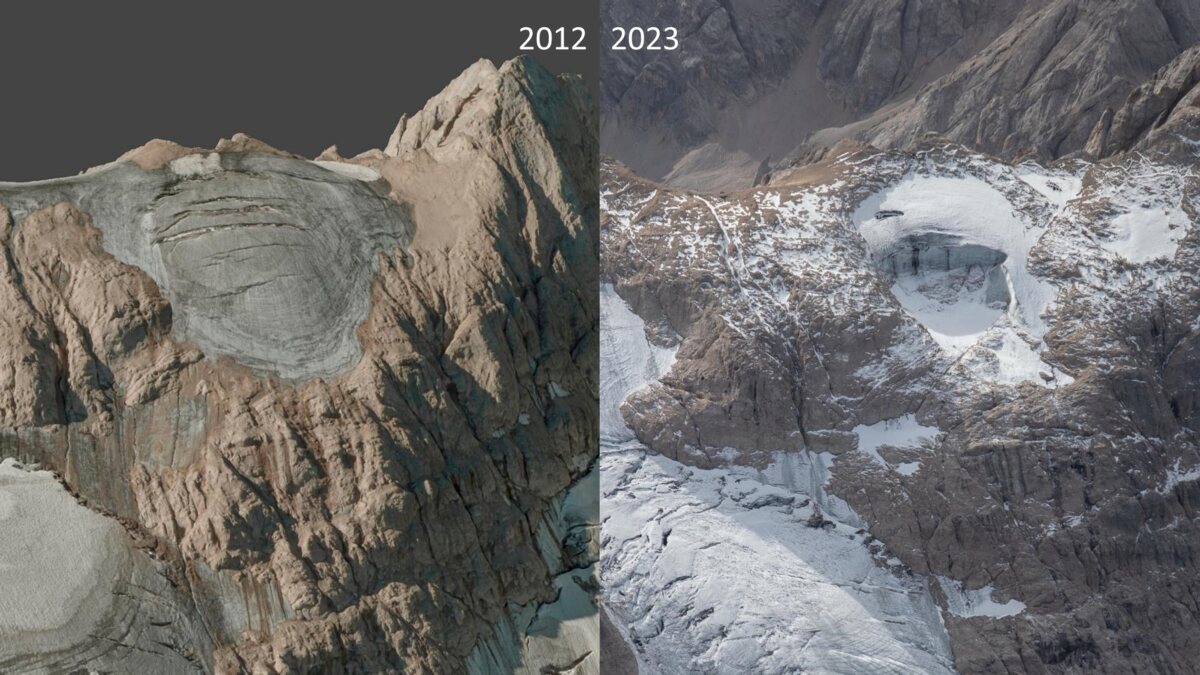
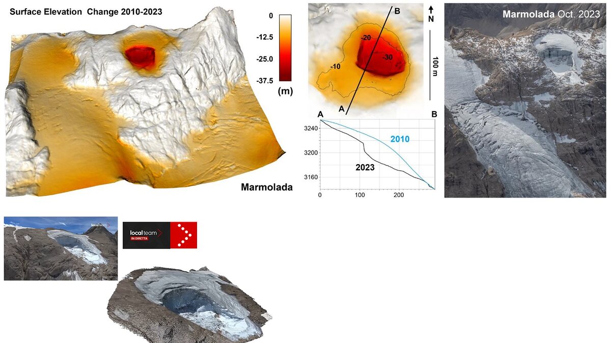
The disaster shares structural similarities with the catastrophic collapse of the Marmolada Glacier in the Italian Dolomites on July 3, 2022, which killed 11 mountaineers. Detailed scientific modeling of Marmolada by researchers (such as Francese et al., 2025) highlighted how warm late-spring temperatures, water-filled crevasses, and hydraulic uplift can trigger sudden ice avalanches without any seismic precursor. Much like Marmolada, the Nepal-Tibet event proves that mass movements can generate seismic signatures entirely independently of tectonic earthquakes.
The Blatten Disaster Analogy (May 2025)
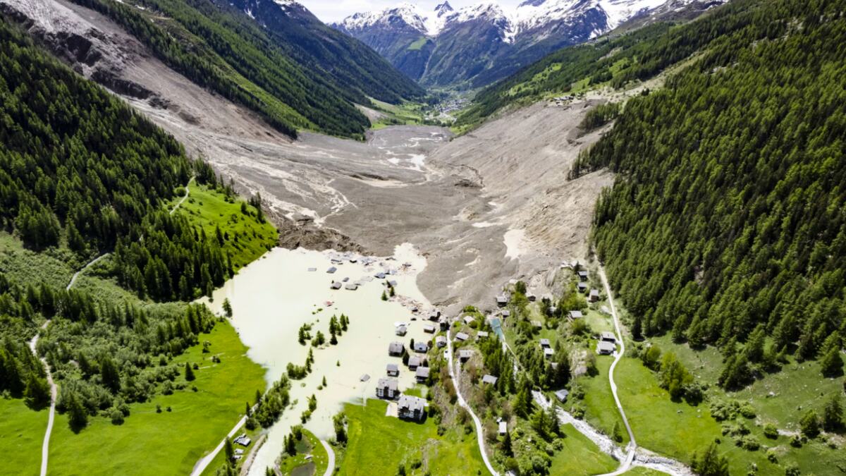
An even closer cascading analog occurred in Switzerland on May 28, 2025, when a massive rock and ice avalanche involving the Birch Glacier mobilized roughly 9.5 million cubic meters of material, burying parts of the village of Blatten and temporarily damming the Lonza River. The Blatten event demonstrated how progressive rock failure can load and destabilize adjacent glaciers, creating a domino-style collapse that transforms from an avalanche into a downstream flood hazard.
The Cryospheric Background of Summer 2026
The disaster unfolded against a backdrop of severe high-altitude instability throughout summer 2026. In the European Alps, researchers at CNRS reported soaring rockfall frequencies across the Mont Blanc massif, driven by extended heatwaves and early snow loss. While local geological conditions dictate individual failures, the regional environmental baseline across high-mountain Asia and Europe is shifting: prolonged positive temperatures are accelerating permafrost thaw, deepening meltwater circulation, and stripping structural support from steep Alpine and Himalayan rock walls.
Official Responses and Rescue Operations
Governments, international bodies, and humanitarian organizations mobilized emergency response protocols immediately following the disaster reports late on August 26.
- Search and Rescue Constraints: Rescue efforts led by Nepalese authorities, alongside international humanitarian teams, faced extreme operational hazards. Road networks were severed, bridges washed away, and continuing instability in the upper catchments made access to the border zones perilous.
- Scientific Coordination: Agencies including ICIMOD, the USGS, and planetary observation teams mobilized satellite tasking to assess the extent of the upper Lhende Khola scar. Experts worked urgently to determine whether remnants of the avalanche dam continued to impound water, which could trigger secondary outburst floods.
- Public Safety Warnings: Nepalese and Tibetan authorities issued high-alert warnings for communities living along the Bhote Koshi and Trishuli corridors, urging residents and remaining recovery crews to evacuate low-lying riverbanks immediately.
Implications: Paradigm Shifts in Monitoring and Transboundary Risk
The August 26 disaster carries profound implications for disaster risk reduction, early-warning systems, and climate adaptation frameworks across mountainous regions.
Dispelling the GLOF Misconception
A critical scientific takeaway is the vital distinction between a Glacial Lake Outburst Flood (GLOF) and an avalanche-induced landslide-dam outburst flood. While initial media reports frequently label all mountain floods as GLOFs, current evidence shows no pre-existing, permanently mapped glacial lake was the primary source. Instead, the temporary lake formed after the avalanche blocked the river. Recognizing this difference is essential; traditional GLOF monitoring relies on tracking known, static lakes with water-level sensors, whereas avalanche dams form and fail too rapidly for standard lake-monitoring networks to capture.
The Transboundary Warning Challenge
The catastrophe starkly illustrates the vulnerability of transboundary river basins. Natural hazards pay no heed to international borders, and flood waves can race down steep Himalayan gorges faster than diplomatic channels or traditional warnings can relay information. Moving forward, warning systems must expand beyond static inventories of glacial lakes to incorporate:
- Real-time seismic monitoring capable of instantly distinguishing tectonic earthquakes from massive mass movements (landslides/avalanches).
- Automated, high-frequency river gauge networks equipped with satellite telemetry.
- Expanded geomorphological surveillance of steep, destabilized glacierised slopes and periglacial rock walls.
Climate Change Context
While cryospheric scientists emphasize that attribution studies are required to quantify the exact role of human-induced climate change in this specific slope failure, the broader context is undeniable. Rapid warming in the Hindu Kush Himalaya is accelerating glacier mass loss, thinning ice tongues, and degrading permafrost. These changes systematically alter the baseline conditions of high-altitude landscapes, increasing the frequency of complex, multi-stage cascading hazards.
As the search and recovery operations continue in the shadow of the Himalayas, the August 26 disaster stands as a stark warning: understanding the intricate chain reactions of high-mountain environments is no longer just an academic pursuit—it is an urgent prerequisite for saving lives in a rapidly warming world.
