

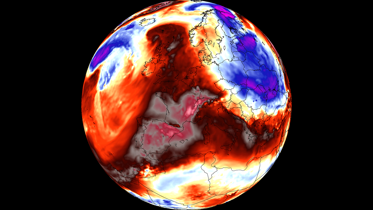
EUROPE — A powerful and unseasonably intense early-September heat dome is expanding rapidly across the European continent, unleashing a punishing late-season heatwave. Surface temperatures are forecast to surge into the upper 30s, with meteorologists warning that localized readings could exceed 40 °C (104 °F) across parts of Southern Europe and the Mediterranean basin.
Driven by a sprawling, warm air plume surging northward out of North Africa, upper-air thermal anomalies are climbing well above seasonal averages. This meteorological phenomenon has set the stage for extreme, summer-like weather conditions across Spain, France, Italy, and the Balkan Peninsula, testing regional infrastructure and public health systems just as meteorological autumn begins.
Main Facts: The Anatomy of the European Heat Dome
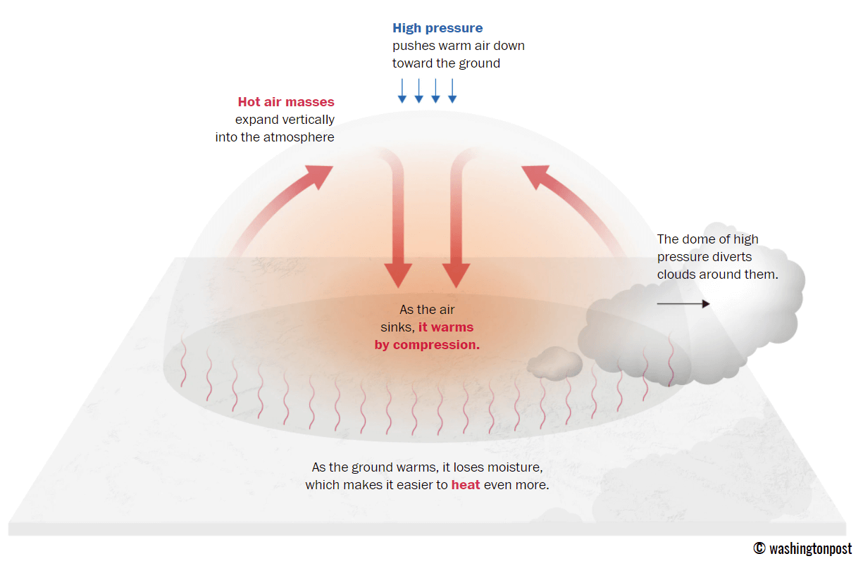
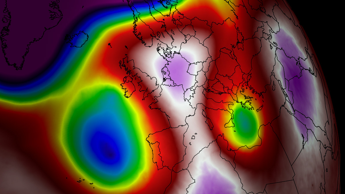
The primary engine behind this late-summer thermal surge is an expansive blocking high-pressure system—frequently referred to in meteorology as a "heat dome"—currently parked over the Mediterranean Basin.
As sinking air within the high-pressure ridge adiabatically compresses and warms the lower atmosphere, a thermal lid is created. This mechanism traps hot air at all levels, rapidly depleting soil moisture via dry continental winds and driving peak afternoon temperatures to extreme levels.
- Temperature Extremes: Low-lying valleys and coastal interiors in Spain, southern France, and Italy are projected to see afternoon highs ranging persistently from 38 °C to 42 °C.
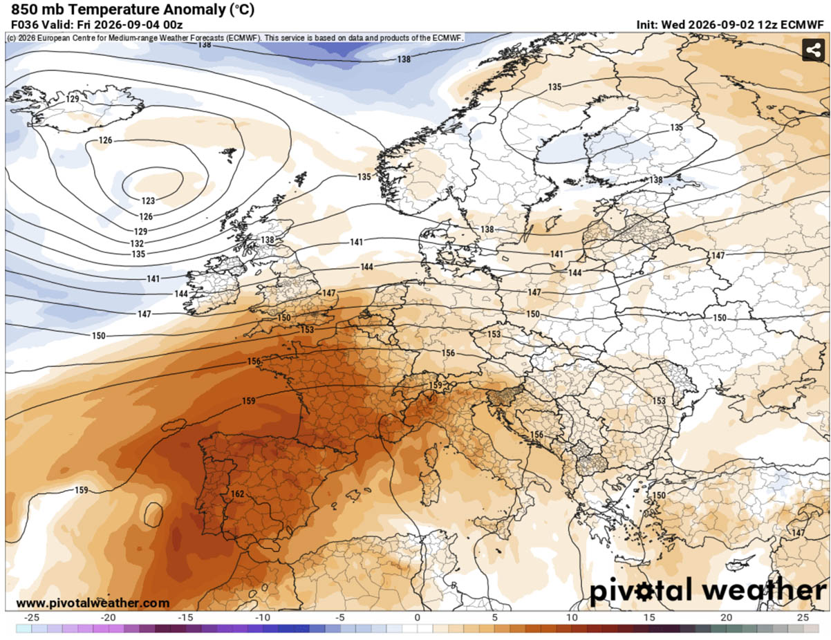
- Thermal Anomalies: Widespread 2-meter surface temperatures are tracking 10 °C to 14 °C above the long-term historical baseline for early September.
- Geographical Footprint: The core of the heatwave heavily impacts the Iberian Peninsula, southern and central France, the Po Valley and Tuscany in Italy, and stretches across the central Balkans and Greece.
- Duration: The atmospheric blocking pattern ensures a prolonged event, holding steady through the weekend and into the middle of next week before a potential weather pattern shift arrives.
Chronology: How the Late-Summer Heat Wave Unfolds
Phase 1: The North African Surge (Mid-to-Late Week)
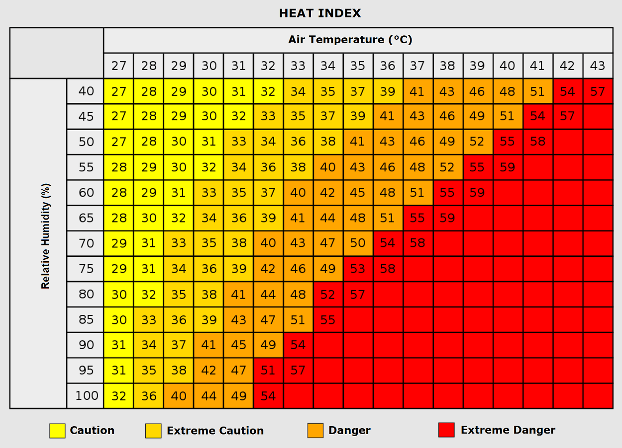
The weather pattern began developing as a robust upper-level ridge expanded across Western and Central Europe, juxtaposed against two deep low-pressure systems situated over the North Atlantic and Northern Europe. By Thursday and Friday, the thermal plume crossed the Mediterranean, locking down over Spain, Portugal, and southwestern France. Central and southern regions of the Iberian Peninsula experienced some of the highest spikes, with isolated valleys recording between 40 °C and 44 °C under exceptionally dry air masses.
Phase 2: Peak Expansion Across Italy and the Balkans (The Weekend)
Over the weekend, the upper-level high-pressure ridge pushes further north and east, dominating the majority of continental Europe. While the deep low over the North Atlantic works to keep temperatures somewhat more regulated across the British Isles and Ireland—where highs hover in the mid-to-upper 20s—the rest of Southern and Central Europe faces the brunt of the heat. Italy and the central Balkans enter peak intensity from Friday through Monday, with temperatures challenging long-standing early September records.
Phase 3: Mid-Week Stability and the Anticipated Pattern Flip (Early-to-Mid Next Week)
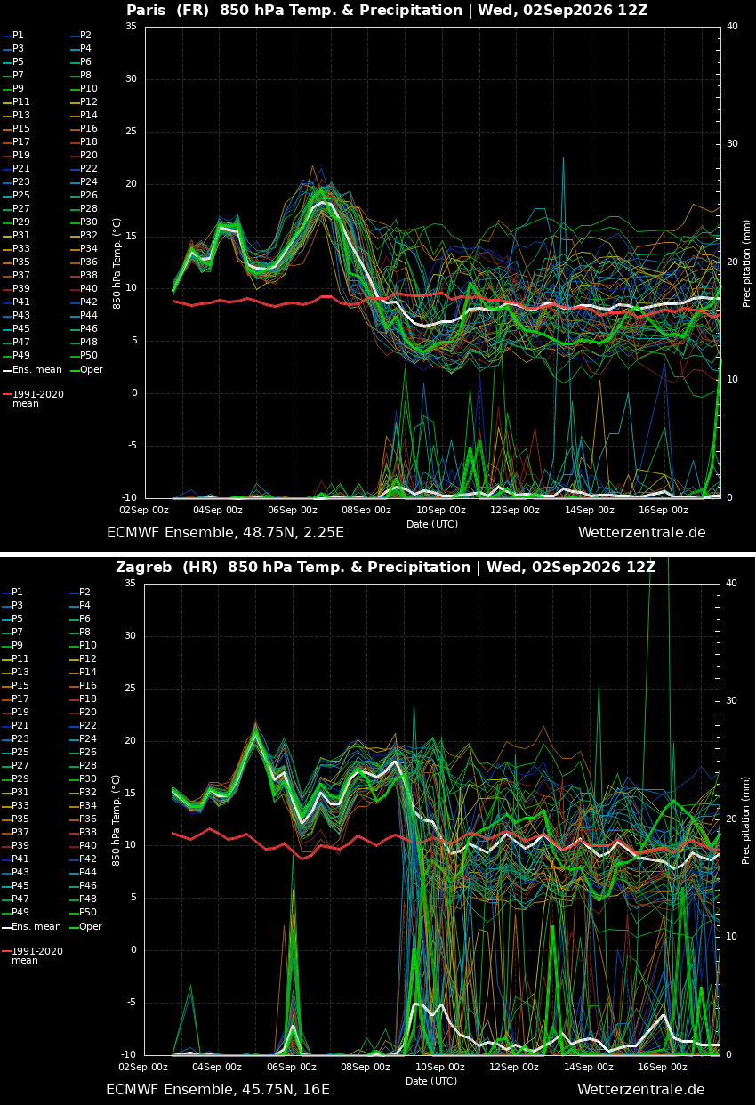
By early next week, the stable, dry air mass maintains its grip on Italy, the Balkans, and parts of Central Europe. However, ensemble weather forecasting models point toward a significant synoptic-scale pattern shift by next Wednesday or Thursday. An emerging upper-level ridge in the North Atlantic is expected to force a deep cold-air mass intrusion into Western Europe, dismantling the heat dome and introducing a much-needed period of cooler temperatures, widespread rain, and potential severe weather.
Supporting Data and Atmospheric Dynamics
Understanding the Heat Dome Mechanism
To comprehend the severity of this event, meteorologists point to the classic mechanics of a heat dome. Operating much like the lid on a pot of boiling water, a persistent upper-level high traps hot air beneath it. As the air descends from the higher altitudes, it compresses, raising its temperature even further.
   [ Upper-Level High Pressure Ridge ]
             (Sinking Air)
                  │
                  ▼  (Adiabatic Compression)
   [ Heat Dome Traps Warm Air at Surface ]
                  │
                  ▼
   [ Extreme Surface Temperatures (38°C - 42°C+) ]
Because this weather pattern is unusually stable, it inhibits the formation of convective clouds, allowing uninterrupted solar radiation to bake the underlying terrain day after day.
The Threat of "Tropical Nights"
Beyond the severe daytime highs, the current heatwave is defined by a dangerous lack of nocturnal relief. Even with the shorter daylight hours typical of early September, minimum overnight temperatures are projected to stay locked between 22 °C and 25 °C across major urban corridors.
These suffocating "tropical nights" deny the human body its vital physiological window to cool down, dramatically compounding heat stress over extended periods.
The Heat Index and Humidity Factors
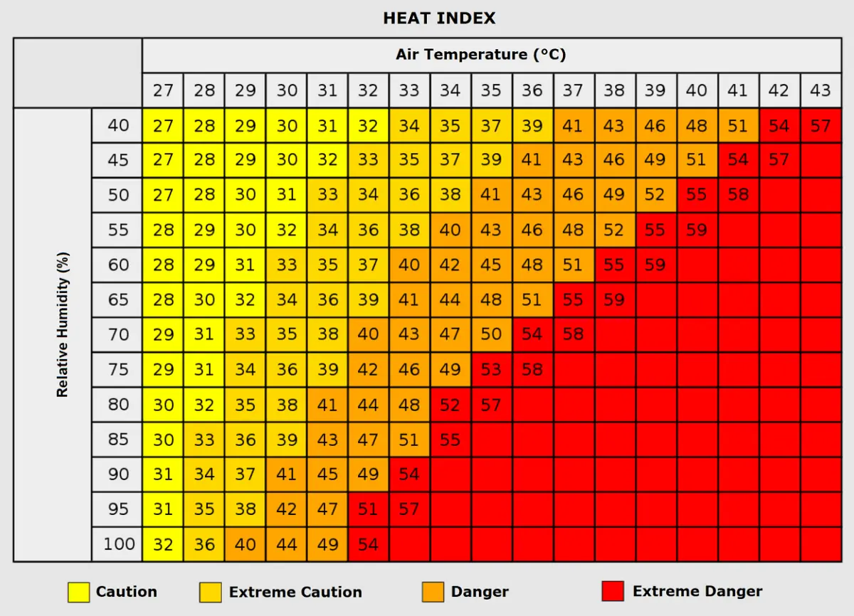
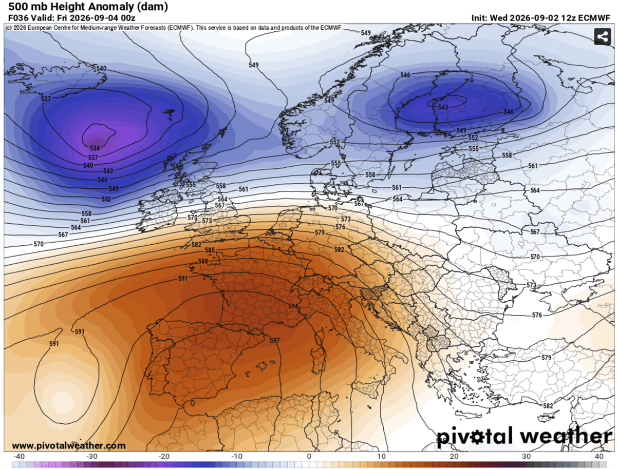
Meteorologists emphasize that temperature alone does not tell the full story; relative humidity plays a critical role in human physiological response. When air masses reach around 35 °C, a humidity level exceeding 80 percent can cause the apparent temperature—or Heat Index—to skyrocket toward 50 °C. High humidity severely impedes the body’s ability to cool itself via sweat evaporation, multiplying the risk of heat-related illnesses.
Official Responses and Implications
Public Health and Vulnerable Populations
Public health authorities across Spain, France, Italy, and the Balkan countries have issued advisories warning citizens of the elevated physiological risks associated with late-season thermal stress.
- Vulnerable Groups: Elderly populations, young children, and individuals with pre-existing cardiovascular or respiratory conditions face heightened risks. Prolonged heatwaves are historically correlated with surges in heart attacks, strokes, and respiratory distress.
- Outdoor Laborers: Construction workers, agricultural laborers, and other outdoor professionals face severe risks of heat exhaustion and heat stroke due to dehydration and relentless exposure.
- Urban Heat Islands: Populations residing in densely populated urban centers—particularly in low-income housing utilizing heat-absorbing materials like concrete and asphalt—are disproportionately vulnerable to indoor heat accumulation.
Energy Grids and Infrastructure
The prolonged nature of the heatwave is placing immense strain on regional energy grids. With residential and commercial air conditioning units running continuously, electricity demand is surging to mid-summer peaks well past the typical end of the cooling season. Grid operators are closely monitoring power reserves to prevent localized brownouts or blackouts.
Wildfire Risk
The combination of sustained high temperatures, dry continental winds, and a lack of rainfall has drastically depleted soil moisture across Southern Europe. Forestry and civil protection agencies have raised wildfire alert levels to high across parched mountain slopes and rural landscapes in Spain, southern France, Italy, and the Balkans, maintaining heightened vigilance as dry brush acts as prime fuel for potential blazes.
Outlook: Relief on the Horizon
While the early-September heat dome continues to dominate the European continent with record-challenging temperatures, long-range meteorological models offer a clear signal of an incoming pattern change.
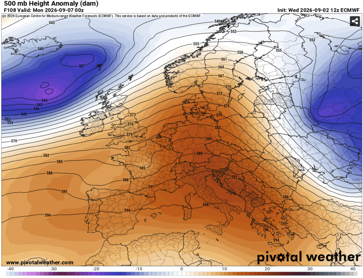
By the middle of next week, the breakdown of the blocking high-pressure system and the arrival of an Atlantic trough are expected to flush out the stagnant air mass. This transition will bring a dramatic drop in temperatures, widespread rainfall, and potential severe weather events to Western and Central Europe, finally closing the chapter on one of the most intense late-season heatwaves in recent memory.
