

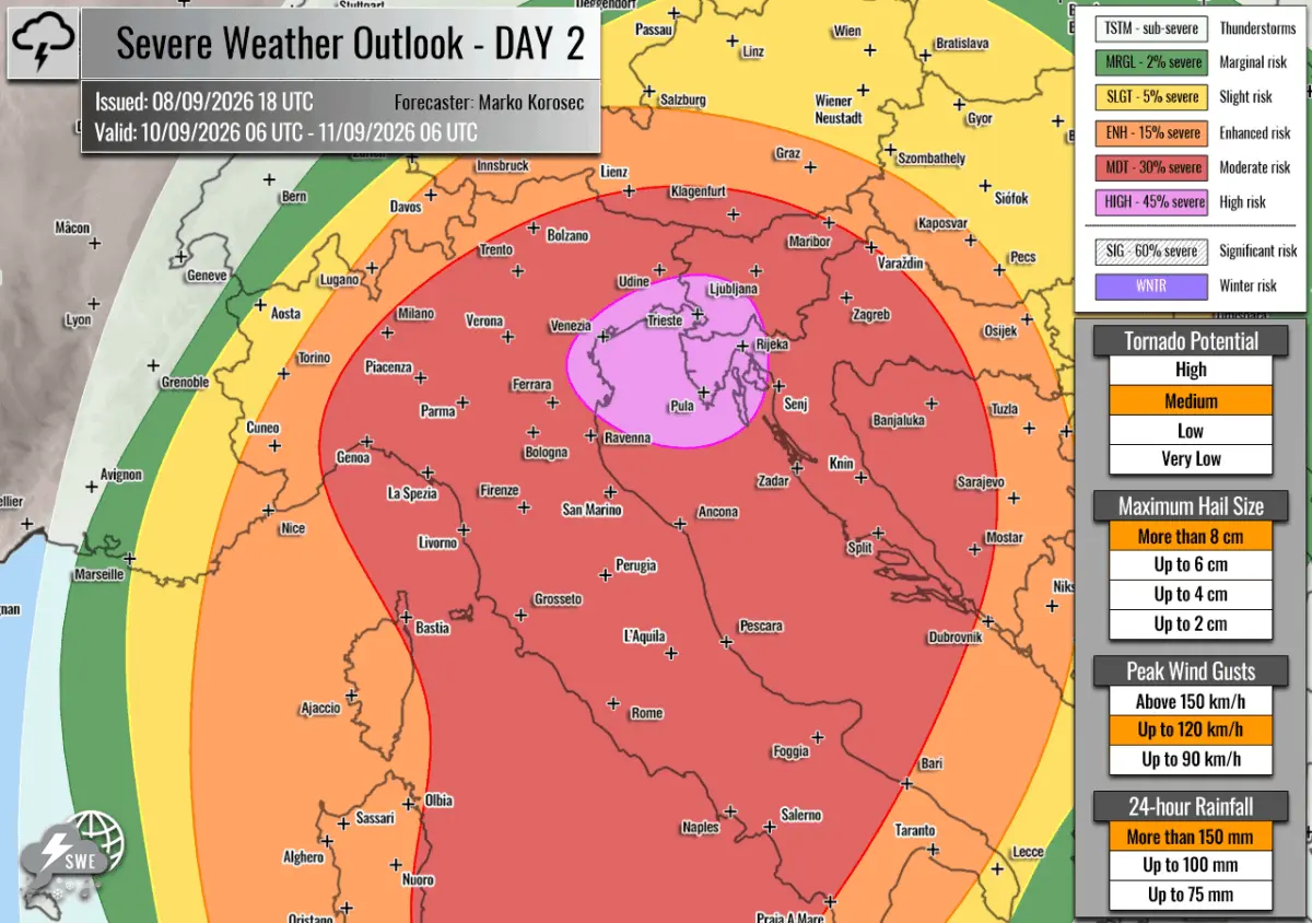
EUROPE — A life-threatening and highly volatile severe weather outbreak is rapidly organizing across the western and northern Mediterranean basins. Meteorological agencies and forecasters have issued rare, elevated warnings for a multi-day convective event set to unleash widespread destruction from the Balearic Islands across southern France, Italy, and into the western Balkans.
Driven by the rare combination of an unseasonably deep upper-level trough, a collapsing eastern blocking high, and historic marine heatwave conditions across Mediterranean waters, the incoming system is expected to spawn torrential downpours, destructive straight-line winds, giant hail, and a significant tornado threat from Wednesday morning through Friday afternoon.
Main Facts
- Event Timeline: A concentrated, highly destructive 48-to-72-hour severe weather window spanning Wednesday, September 9, through Friday afternoon, September 11, 2026.
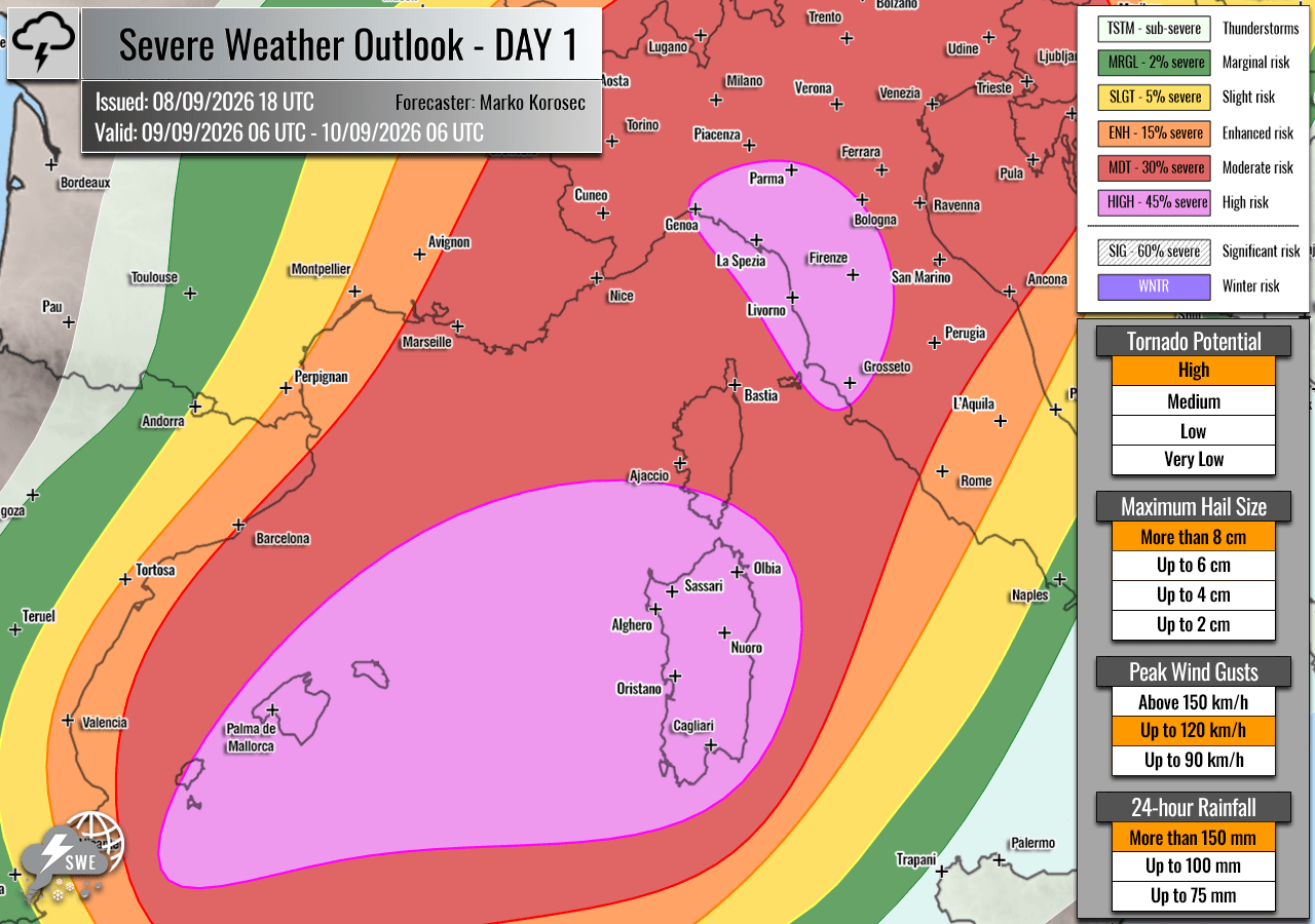
- Primary Impact Zones: The Balearic Islands, southern Corsica, Sardinia, Liguria, Tuscany, northeastern Italy, the Po Valley, western Slovenia, and northwestern Croatia.
- Alert Levels: HIGH and Moderate (MDT) risks have been officially designated by Severe Weather Europe, highlighting areas most vulnerable to explosive supercell development.
- Core Threats:
- Torrential Rains & Flash Floods: Localized rainfall accumulations exceeding 200 mm to 300 mm within a 36-hour window, raising severe flash-flood concerns over drought-stricken soils.
- Large to Giant Hail: Stone diameters ranging from 6 cm to 10 cm (or larger), capable of causing severe structural and vehicular damage.
- Destructive Winds: Severe straight-line wind gusts capable of downing power lines, ripping roofs off buildings, and snapping mature trees.
- Tornadoes: Enhanced parameters for intense, low-level rotational supercells, particularly across the Balearic Islands, coastal Italy, and the Ligurian/Tuscan regions.
- Meteorological Drivers: A sharp southwesterly jet stream interacting with marine air masses boasting extreme dewpoints (near or exceeding 25°C), generating MLCAPE values of 3,000 to over 4,000 J/kg.
Chronology of the Outbreak
The atmospheric mechanisms driving this severe weather episode began developing as a large, deep upper-level trough emerged over Western Europe. Pushing eastward, the trough has begun undercutting and collapsing a robust blocking high-pressure system anchored over Eastern Europe. The resulting pressure and temperature gradients have supercharged the southwesterly jet stream, setting the stage for a classic, high-shear, high-instability Mediterranean convective event.

Wednesday, September 9: The Initial Ignition
The severe weather onslaught commences early Wednesday morning. As a racing cold front sweeps eastward from France and the Alpine foothills toward the Mediterranean basin, it encounters an extremely humid, unstable air mass fueled by lingering marine heatwaves.
- Morning to Early Afternoon: Explosive thunderstorm development is forecast to spark first over the Balearic Islands, the Ligurian Bay, and northwestern Italy. Forecasters note that discrete, highly violent supercells will be the primary mode of convection early on. The Balearic Islands face a maximized tornado threat due to localized storm-relative helicity and intense low-level shear.
- Late Afternoon to Evening: Storms will track east-northeastward, organizing into complex clusters and severe squall lines. Southern Corsica, Sardinia, Tuscany, and Liguria will experience severe threats, including very large hail and high-end wind gusts. In addition, moisture funneled up the Po Valley will spark intense supercell growth capable of producing giant hail and tornadoes. By nightfall, the storm clusters will cross into western Slovenia and northwestern Croatia, maintaining their destructive intensity fueled by high wind shear.
Thursday, September 10: Peak Severity Across Italy and the Balkans
On Thursday, the atmospheric energy shifts eastward, focusing the primary severe weather targets across northeastern Italy, the northern Adriatic Sea, western Slovenia, and northwestern Croatia.
- All-Day Convective Threat: Slow-moving multicells and cyclic supercells will repeatedly impact the same geographic corridors, resulting in a dangerous phenomenon known as "storm training." As successive waves of severe weather move onshore from the Tyrrhenian and Adriatic seas, rainfall rates will skyrocket.
- Nighttime Progression: The convective systems will coalesce into massive squall lines, posing persistent threats of destructive straight-line winds and torrential rainfall straight through to Friday morning.
Friday, September 11: Gradual Easing
By Friday afternoon, the primary cold front will push deeper into the Balkan peninsula, slowly stabilizing the western Mediterranean basins. However, residual heavy showers and isolated strong storms will continue to affect parts of central Italy and the southern Adriatic before the weather system finally dissipates over southeastern Europe.
Supporting Data and Meteorological Analysis
The severity of this upcoming outbreak is rooted in extreme thermodynamic and kinematic parameters rarely seen outside of peak summer or tropical transition phases.
Instability (CAPE)
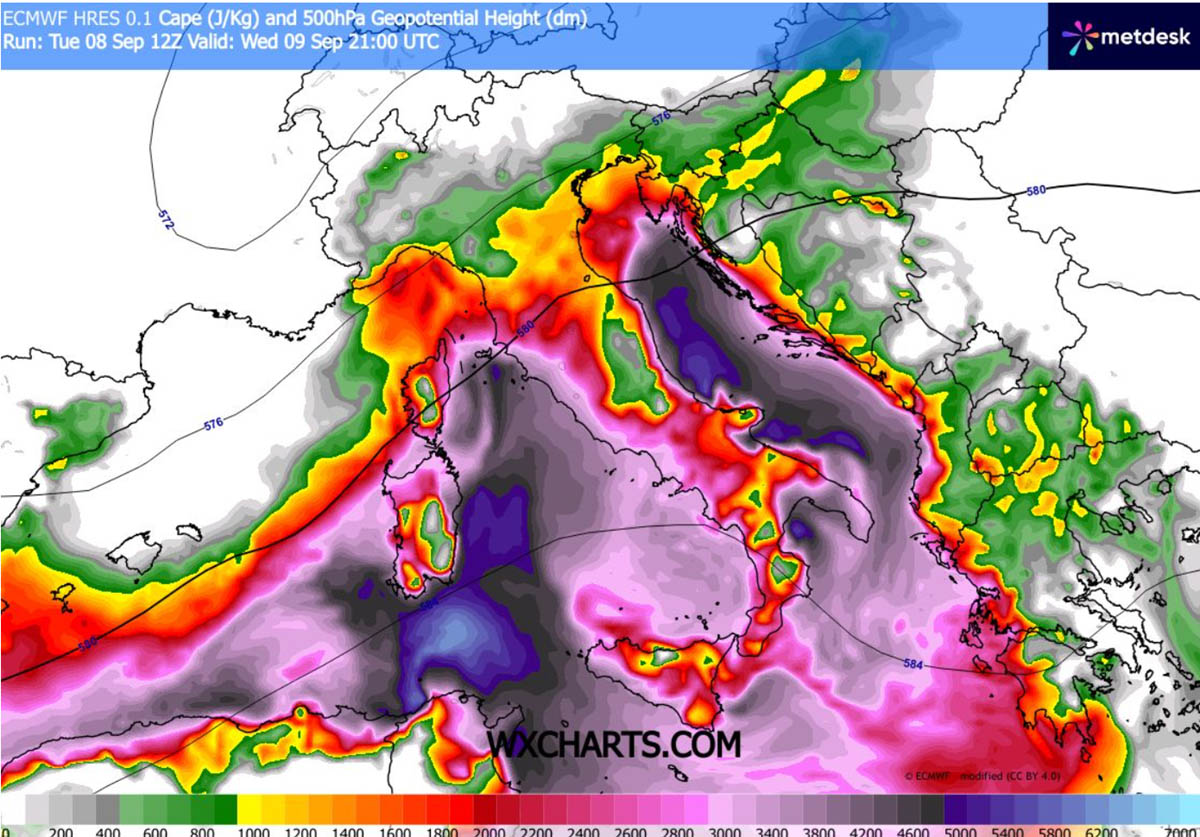
The prolonged marine heatwave across the Mediterranean has left surface waters exceptionally warm. As strong southerly winds off the Tyrrhenian and Adriatic seas advect moisture inland, surface dewpoints are surging to near or above 25°C. When combined with steep mid-level lapse rates induced by the approaching cold front, Convective Available Potential Energy (CAPE) values are modeled to reach 3,000 to 4,000+ J/kg across the high-risk zones. This represents an extreme level of atmospheric buoyancy capable of accelerating updrafts to extreme velocities.
Wind Shear and Dynamics
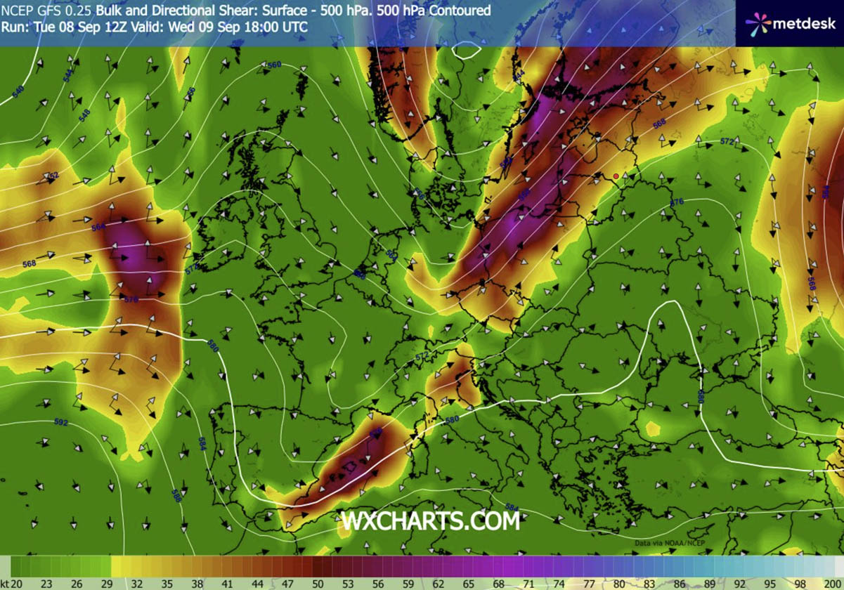
A robust mid-level jet stream, operating in the left exit region of the upper trough, is providing phenomenal vertical wind shear. Deep-layer shear values in excess of 25–30 m/s will allow thunderstorms to maintain structural organization, evolving into long-lived supercells. Furthermore, localized backing of surface winds near coastal boundaries and low-level jet enhancements will maximize Storm-Relative Helicity (SRH), creating an environment highly conducive to tornadogenesis.
Rainfall Modeling and Hydrological Impact
High-resolution weather prediction models indicate localized rainfall sums exceeding 200 mm within 24 hours, with localized peaks reaching 300 mm over 36 hours. Because large swaths of the affected regions—particularly in parts of Italy and the Balkans—have endured severe, prolonged drought conditions over the spring and summer, the soil has baked hard and lost much of its natural absorption capacity. Consequently, the rapid influx of torrential rainfall cannot be absorbed quickly, drastically multiplying the risk of catastrophic, life-threatening flash floods and mudslides in urban and mountainous terrain alike.
Official Responses and Preparedness
Civil protection agencies, meteorological services, and municipal authorities across Spain (Balearic Islands), France, Italy, Slovenia, and Croatia have placed emergency response teams on high alert.
- Pre-emptive Warnings: Red and orange weather alerts have been broadcast across vulnerable provinces, advising residents to secure outdoor property, avoid unnecessary travel, and prepare for potential power outages.
- Municipal Precautions: Local councils in Liguria, Tuscany, and the Po Valley have closed public parks, river walkways, and subterranean underpasses prone to sudden inundation. Emergency rescue services, including swift-water rescue units and urban search-and-rescue teams, have been staged near historical flood-risk zones.
- Aviation and Maritime Advisories: Port authorities across the northern Adriatic and western Mediterranean have issued gale warnings for maritime traffic, advising commercial vessels and ferries to remain in port. Major European airports are warning passengers of potential delays and ground stops as severe convective cells sweep across flight paths.
Implications
This severe weather outbreak carries profound implications for infrastructure, agriculture, and public safety across southern and central Europe.
- Agricultural Devastation: The arrival of 6 cm to 10 cm hail stones poses a catastrophic threat to late-season agricultural yields, vineyards, and orchards across northern Italy and the Balkans, potentially wiping out months of harvest work in minutes.
- Infrastructure Strain: Urban centers unaccustomed to such extreme precipitation rates face severe drainage system failures, structural erosion, and widespread transportation gridlocks. Prolonged power outages from straight-line wind damage are expected to impact hundreds of thousands of households.
- Climate Context: Meteorologists point out that the severity of this event is heavily exacerbated by abnormally warm Mediterranean sea surface temperatures. As marine heatwaves become more frequent and intense due to broader climatic shifts, the atmospheric capacity to store and release moisture increases, setting the stage for more volatile, high-impact weather outbursts across Southern Europe.
Residents and travelers within the designated HIGH and MDT risk zones are strongly urged to monitor local meteorological broadcasts continuously and heed all evacuation or safety directives issued by civil protection authorities as the outbreak unfolds.
