

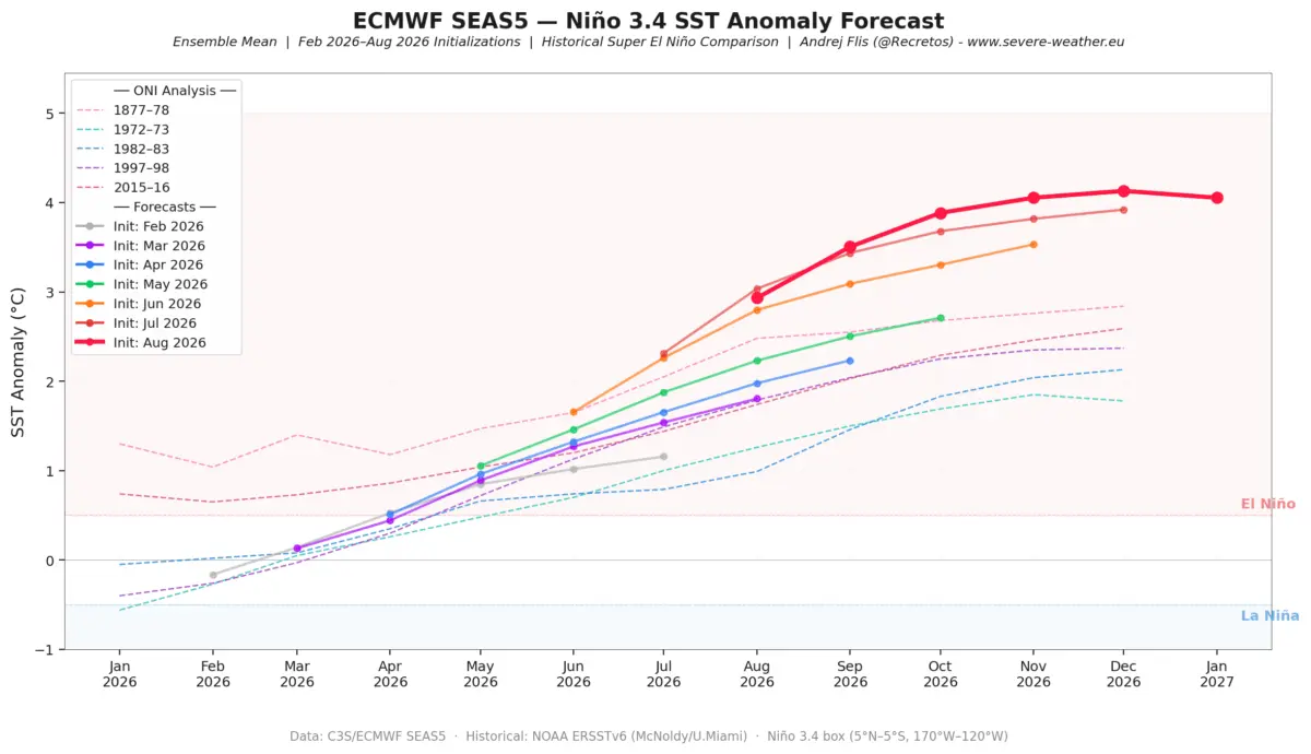
As meteorological agencies and global climate monitors look toward the cold-weather season, long-range models are converging on a rare and high-impact atmospheric driver. Winter 2026/2027 is rapidly shaping up around the development of a powerful Super El Niño, with seasonal forecasts pointing toward an intensely amplified, split-flow weather pattern across North America and varying impacts stretching toward Europe.

Main Facts: The Anatomy of a Super El Niño
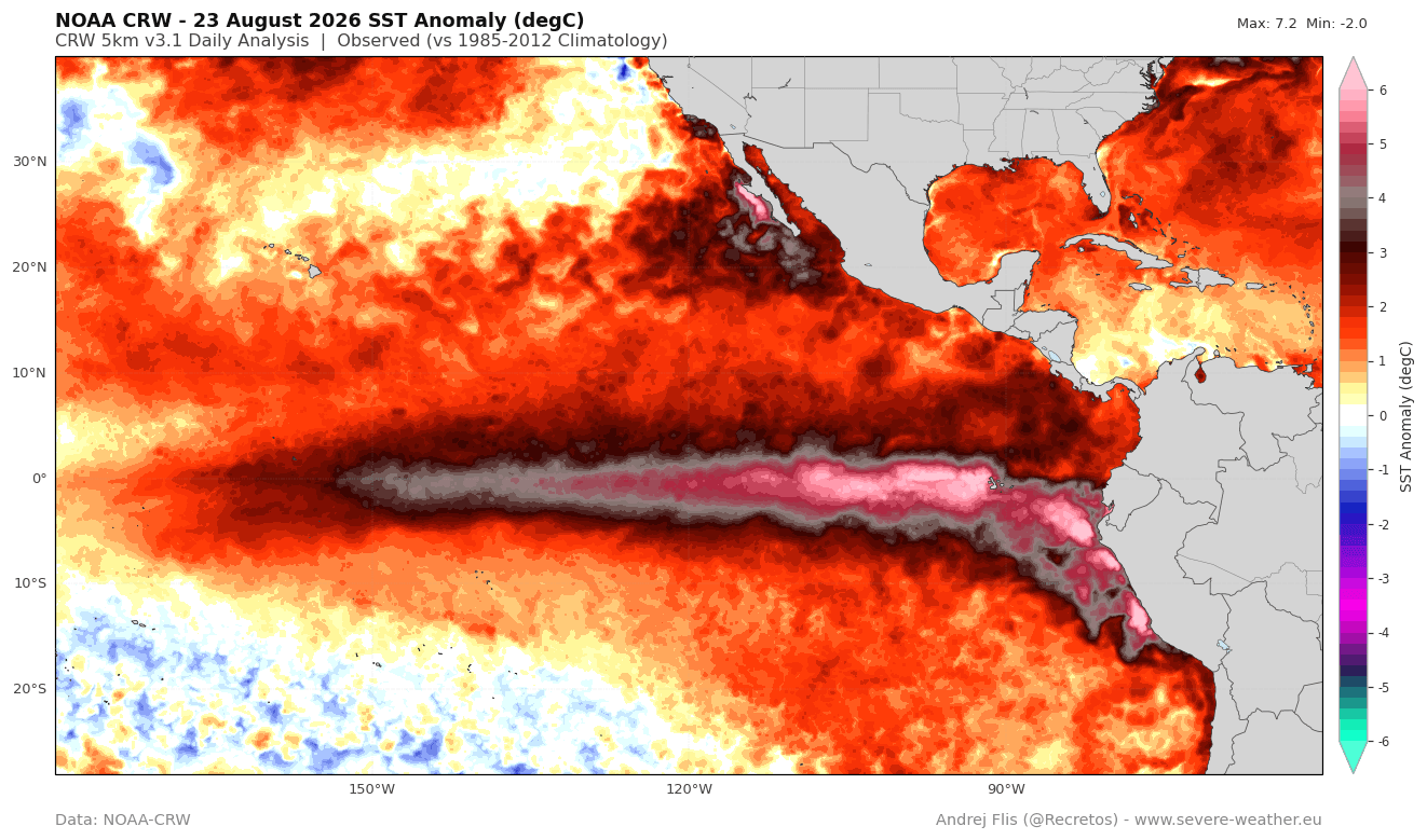
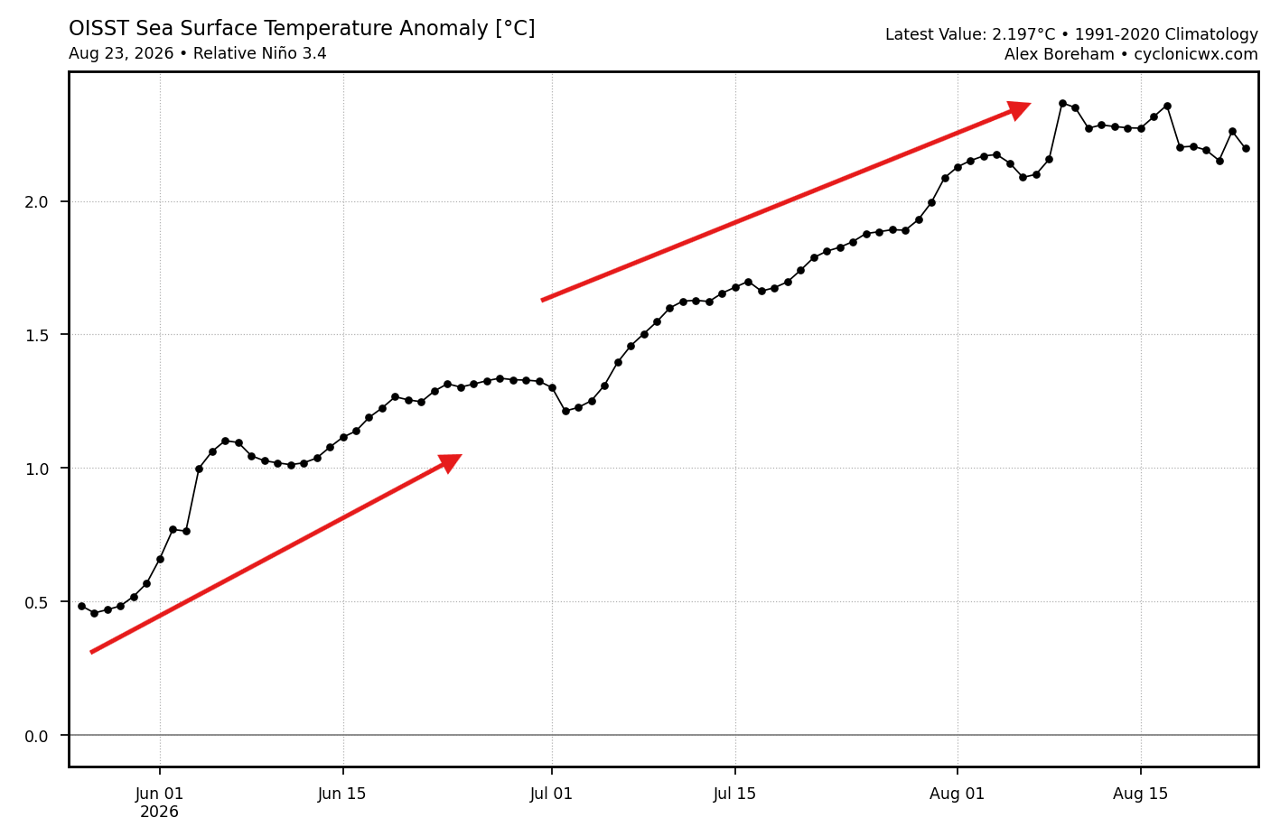
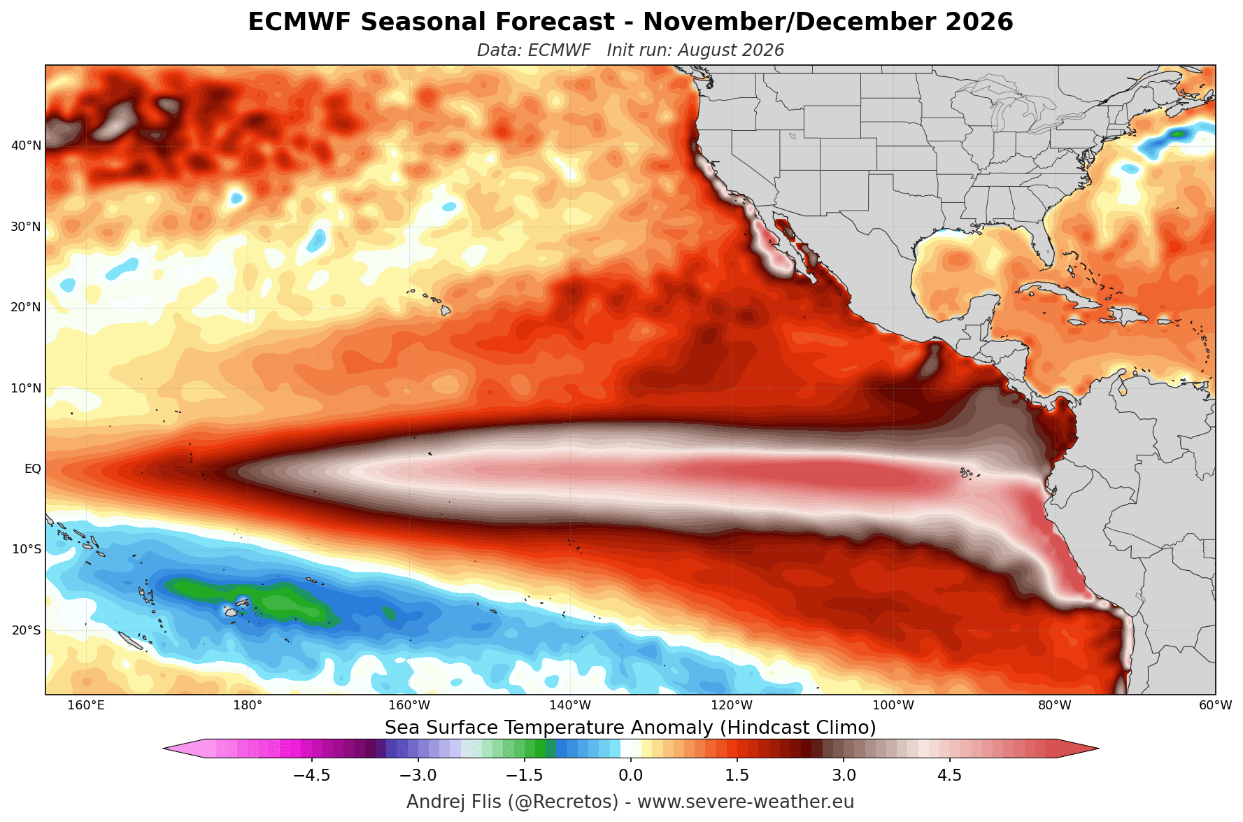
At the core of the upcoming winter forecast is an exceptional buildup of ocean heat in the tropical Pacific. Current oceanographic data—analyzed via NOAA Coral Reef Watch (CRW) and OISST monitoring systems—shows a rapid and continuous climb in sea surface temperatures.
- The Threshold: To be officially classified as a Super El Niño, sustained seasonal anomalies must exceed +2°C above normal. Current readings have already surpassed this threshold, with certain zones registering temperature anomalies exceeding +6°C (11°F) above average.
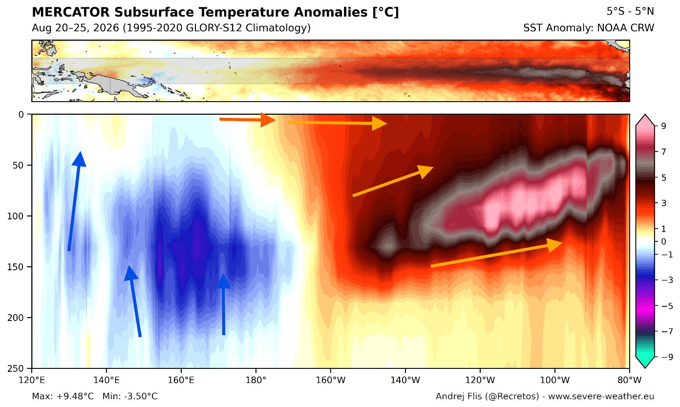
- The Engine (Kelvin Waves): Subsurface data highlights a massive downwelling Kelvin wave in the upper 250 meters (800 feet) of the tropical Pacific, featuring core anomalies more than 9°F to 16°F above normal. This subsurface warm pool serves as a continuous energy engine, ensuring the El Niño remains robust and resilient well into the winter months.
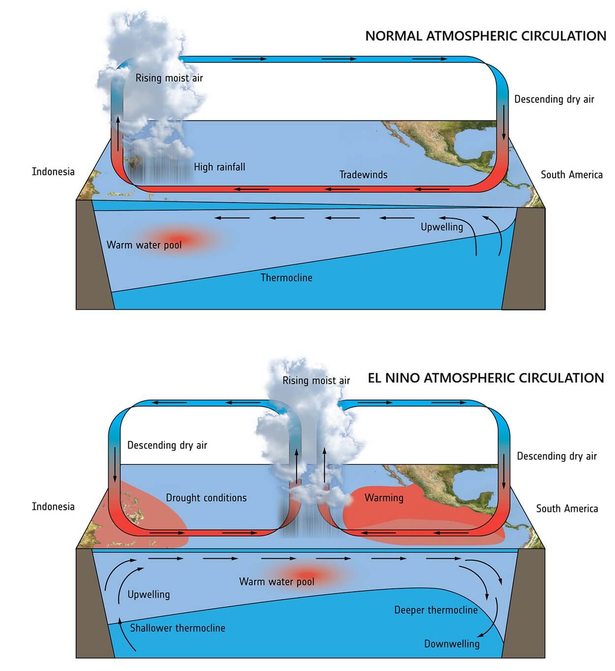
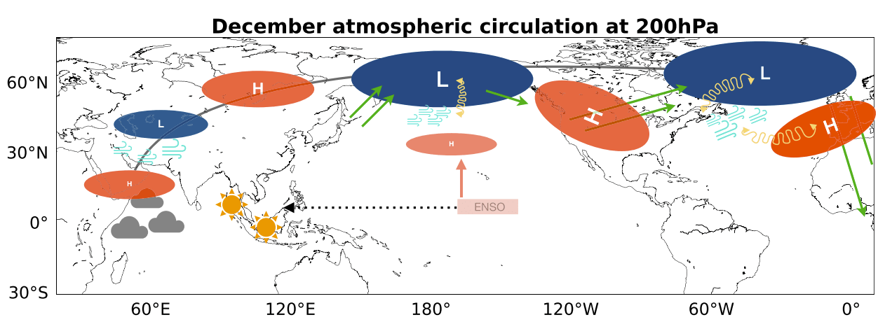
- Global Teleconnections: El Niño alters the Walker Circulation—the tropical east-west atmospheric motion—lowering surface pressure in the central and eastern Pacific while building high pressure over the west. This dynamic triggers massive planetary-scale Rossby wave trains that reshape jet streams across both hemispheres.
Chronology and Model Evolution: From Summer Buildup to Winter Peaks
Tracking a Super El Niño requires continuous adjustments from seasonal forecast models, which dynamically simulate both ocean and atmospheric parameters.
Summer into Fall 2026: Rapid Intensification
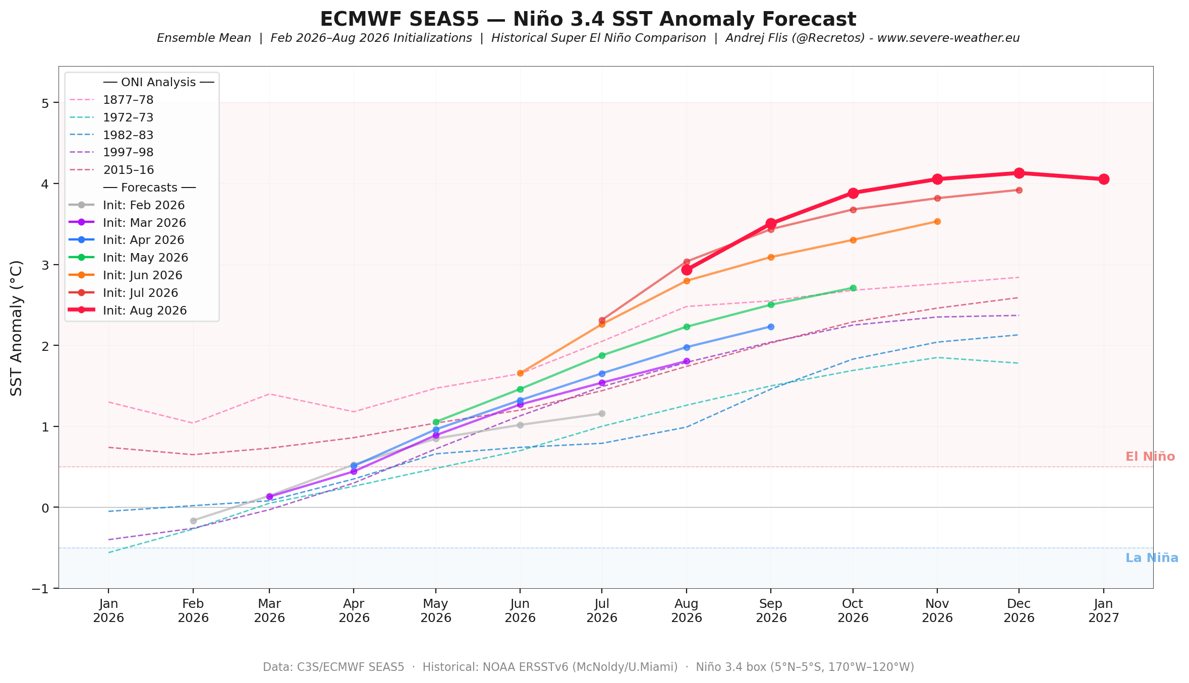
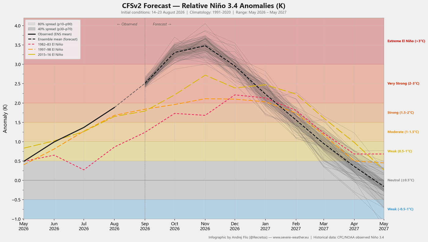
Throughout the summer months, observational data captured the rapid eastward propagation of subsurface Kelvin waves. As successive runs of leading global models—including Europe’s ECMWF SEAS5 and NOAA’s NCEP CFSv2—processed these updates, forecasters watched peak projected anomalies steadily trend upward. By late August and early September, models pushed the anticipated peak into historic, record-strong territory, outperforming standard moderate-to-strong El Niño parameters and rivaling historical benchmark events.
November and December 2026: The Seasonal Pivot
As the ocean anomaly nears its peak intensity around late autumn, its atmospheric footprint solidifies. The classic El Niño teleconnection takes full effect, establishing a deep Aleutian low-pressure trough over the North Pacific. This feature acts as a primary catalyst for the winter jet stream, forcing a dominant high-pressure ridge over Canada and setting the stage for a classic split-flow pattern across the United States.
January and February 2027: Mid-Winter Amplification
Projections from both the ECMWF and the North American Multi-Model Ensemble (NMME) indicate that the atmospheric pressure anomalies will not merely maintain their footprint but will amplify as winter progresses. January and February are slated to feature a deeply entrenched Canadian blocking high paired with an active southern storm track, potentially working in tandem with a disrupted stratospheric Polar Vortex to drive periodic cold-air outbreaks into the mid-latitudes.
Supporting Data: Historical Analogues and Model Consensus
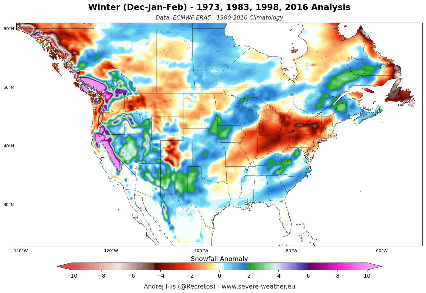
Forecasting an event of this magnitude relies heavily on comparing current telemetry against historical Super El Niño winters, such as those recorded in 1982–83, 1997–98, and 2015–16.
Historical Pressure and Temperature Composites
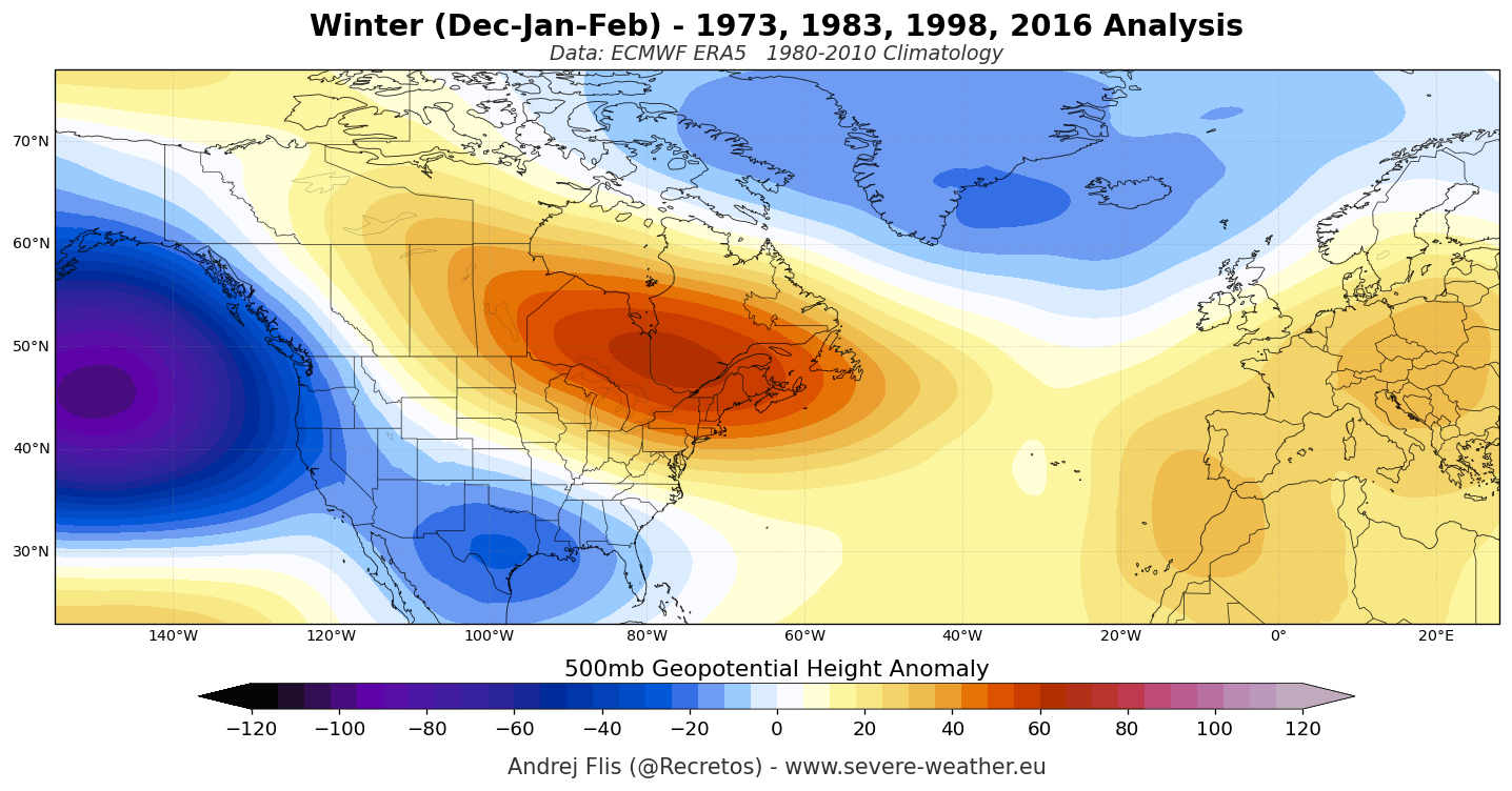
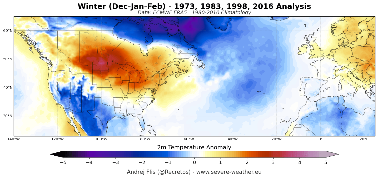
An ERA5 reanalysis composite of past Super El Niño winters reveals a distinct, highly repeatable pattern:
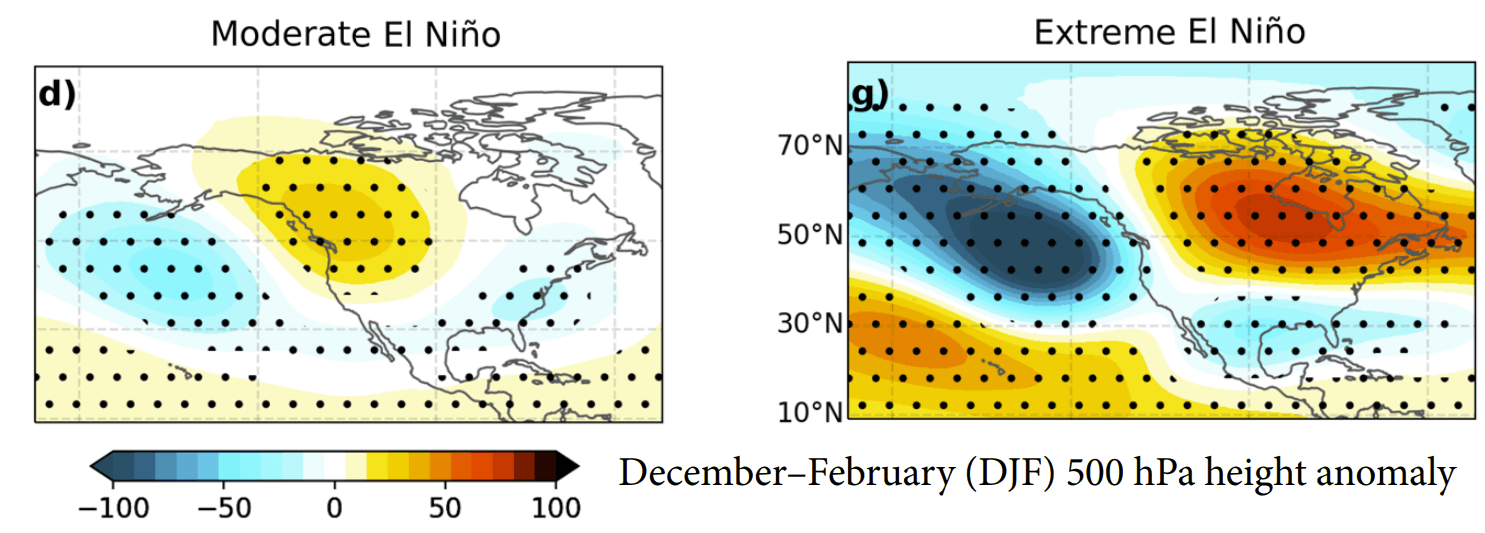
- The Pressure Gradient: A deep North Pacific trough forces a massive ridge across Canada, Northern U.S. plains, and the Great Lakes. Downstream, lower pressure dominates the North Atlantic, promoting a milder westerly flow into mainland Europe.
- Temperature Contrasts: Well-above-normal temperatures consistently manifest beneath the Canadian and northern U.S. high-pressure zones. Conversely, persistent cloud cover and storm activity keep the southern United States cooler and wetter than average.
- Snowfall Distribution: Historical snow anomalies show heavy seasonal accumulation concentrated across the Sierra Nevada, the Four Corners, the Southern Rockies, and parts of the Central Plains. Meanwhile, the Pacific Northwest, Great Lakes, and Northeast typically experience pronounced snowfall deficits due to suppressed northern storm tracks and mild Canadian air masses.
Multi-Model Agreement (ECMWF & NMME)
Confidence in the Winter 2026/2027 outlook is bolstered by strong multi-model consensus. Both the ECMWF seasonal suite and NOAA’s NMME project identical large-scale structures:
- Precipitation Anomalies: Enhanced moisture transport via an amplified subtropical jet stream is projected to bring above-normal precipitation to the West Coast, the Gulf Coast, and the Southeast and East of the United States.
- European Outlook: Both models project a predominantly mild westerly and southwesterly Atlantic flow for Europe, favoring above-average winter temperatures across much of the continent, interspersed with periodic northerly dips driven by Atlantic low-pressure systems tracking into Northern Europe.
Stratospheric Signals: The Polar Vortex Factor
While tropical forcing dictates the baseline climate state, the stratospheric Polar Vortex introduces a powerful variable capable of altering mid-winter weather on a sub-seasonal scale.
The Polar Vortex—a vast ring of circumpolar westerly winds trapping frigid air over the Arctic—exhibits a unique evolutionary tendency during strong El Niño years. Atmospheric research demonstrates that intense upward-propagating wave energy from a Super El Niño can place severe stress on the stratosphere, frequently leading to a deceleration or complete disruption of the vortex in mid-winter.
Both the ECMWF and UKMO stratospheric forecasts indicate an unusual slowdown in zonal winds at the 10hPa level (approx. 30 km altitude) around late December and January. While this does not guarantee a specific Sudden Stratospheric Warming (SSW) event months in advance, it points to a weakened, more vulnerable vortex state. If a major disruption occurs and translates downward into the troposphere, it can fracture the jet stream, occasionally allowing the "Polar Express" effect to punch cold air southward despite the prevailing El Niño background state.
Implications: Regional Impacts for North America and Europe
The convergence of a record-seeking Super El Niño and potential mid-winter stratospheric variability carries distinct socioeconomic and environmental implications across key regions.
United States and Canada
- The Ski and Winter Sports Industry: A stark north-south divide is forecast for winter resort operators. Resorts across California’s Sierra Nevada, Utah, and the Central-to-Southern Rockies are positioned for robust snowpacks driven by active southern storm tracks. Conversely, operations in the Pacific Northwest, the Northern Rockies, Northern New England, and British Columbia face a challenging setup with persistent mild conditions limiting natural accumulation.
- Energy and Infrastructure: Above-normal temperatures across the Canadian Prairies and Northern Plains may reduce regional heating demands, while the active southern and eastern storm tracks increase the risk of severe weather, heavy localized rains, and disruptive ice or snow events in the Mid-Atlantic and Southeast.
Europe
- The Alpine Elevation Divide: With a dominant Atlantic westerly flow driving widespread seasonal warmth across European lowlands and mid-elevations, resorts in the Pyrenees, Apennines, Balkans, and Scottish Highlands may struggle with subpar natural snow depths.
- High-Altitude Reliability: Because Atlantic systems carry substantial moisture, ski areas situated at higher elevations (above 1,800 to 2,000 meters) in the western and central Alps remain viable, provided temperatures stay sufficiently cold during precipitation events. Consistent deep-snow conditions will favor high-latitude and high-altitude zones across northern and northeastern Europe.
As atmospheric conditions continue to evolve ahead of the calendar winter, meteorological agencies will issue updated monthly breakdowns. Stakeholders across agriculture, energy, and emergency management, as well as winter recreation enthusiasts, are advised to monitor ongoing updates as the 2026/2027 Super El Niño takes full command of the global climate system.
