

September 21, 2026 — As meteorological autumn gets underway, long-range forecasting models for the upcoming winter season are pointing toward a dominant, highly influential global weather driver: a rapidly developing Super El Niño.
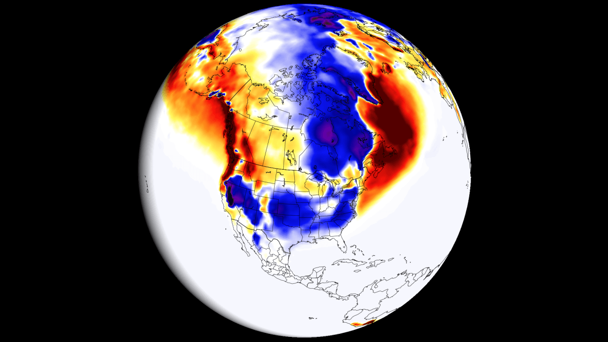
Initial snowfall predictions for the Winter of 2026/2027 reveal stark, contrasting patterns across the United States, Canada, and Europe. Driven by historic sea surface temperature anomalies in the tropical Pacific Ocean, this unfolding climate phenomenon is already fundamentally altering the jet stream and restructuring low-pressure system tracks across the Northern Hemisphere.
Main Facts: The 2026/2027 Winter Snowfall Blueprint
The primary catalyst for the upcoming winter’s weather is an exceptionally robust El Niño event currently surging in the equatorial Pacific. Meteorologists categorize this as a "Super El Niño"—a formal designation reserved exclusively for events where sustained seasonal temperature anomalies exceed the +2°C threshold. Current observations indicate that this threshold has already been surpassed, placing the 2026/2027 event on track to be one of the strongest in modern recorded history.
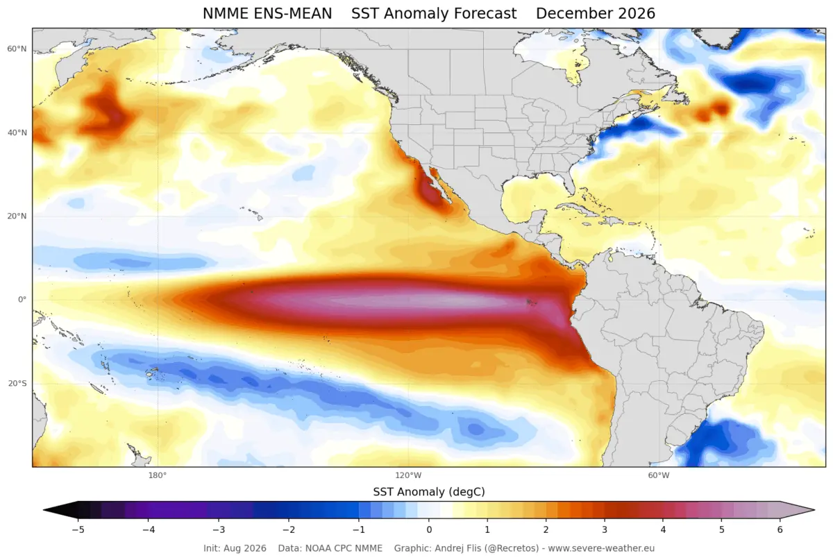
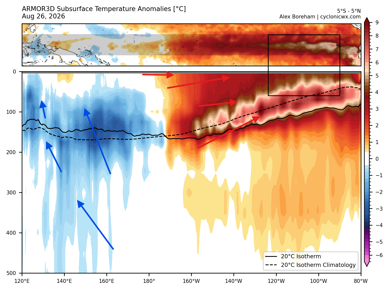
- The Pacific Driver: Sea surface temperature anomalies in the eastern tropical Pacific are soaring, with peak anomalies exceeding 6°C (10.8°F) above normal. Subsurface data highlights a massive downwelling Kelvin Wave, featuring core temperature anomalies exceeding 10°C (18°F) above normal. This immense reservoir of warm subsurface water is currently surging toward the surface, ensuring that the El Niño will remain a dominant force throughout the winter months.
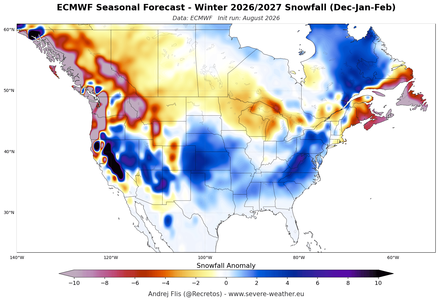
- North American Impacts: The developing Super El Niño is actively forcing a split in the jet stream, weakening the polar jet while dramatically strengthening the southern subtropical Pacific jet stream. This configuration favors increased snowfall potential across the central and eastern United States, the southern Rockies, and portions of the Mid-Atlantic. Conversely, the Pacific Northwest, the northern tier of the U.S., and southern Canada face notable snowfall deficits.
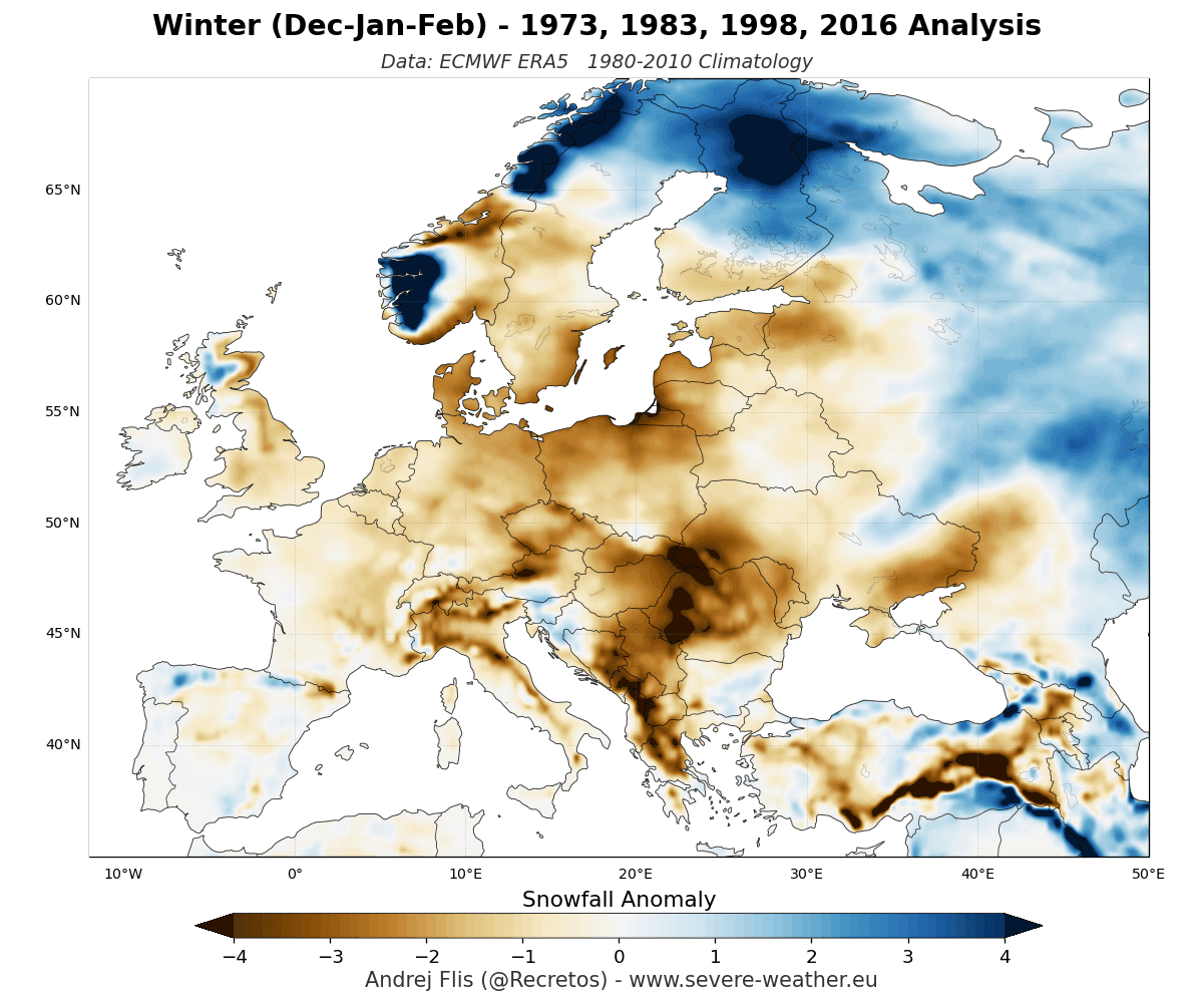
- European Impacts: Europe faces a predominantly mild winter outlook. Long-range models from both the European Centre for Medium-Range Weather Forecasts (ECMWF) and the UK Meteorological Office (UKMO) project widespread below-normal snowfall across the lowlands and mid-elevations. A persistent high-pressure ridge over southern Europe combined with an active Atlantic westerly flow will generally keep temperatures too high to support widespread snow cover, restricting significant accumulations primarily to high-altitude regions like the Alps and far-northern latitudes.
Chronology of the Event: From Ocean Anomalies to Seasonal Forecasts
Understanding how a tropical ocean phenomenon translates into winter snowstorms thousands of miles away requires looking at the sequence of atmospheric developments leading up to the cold season.
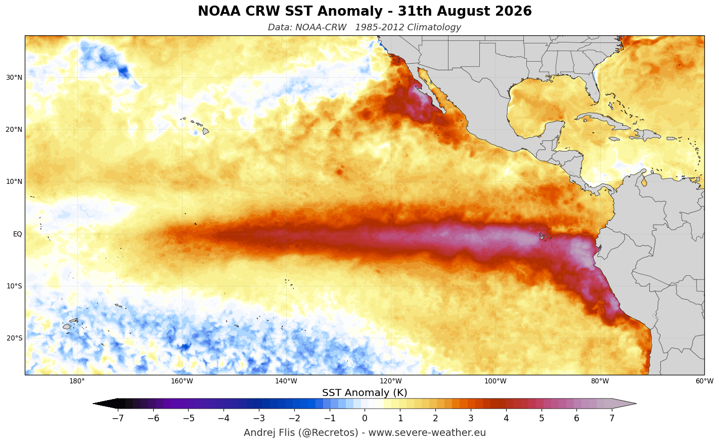
Summer into Fall 2026: The Rise of the Kelvin Wave
During the late summer months of 2026, NOAA-CRW ocean analysis revealed rapid warming across the tropical Pacific. Strong westerly wind bursts began displacing warm upper-ocean waters eastward, generating a powerful Kelvin Wave. This subsurface wave acted as a conveyor belt of thermal energy, driving surface temperatures to extreme heights and establishing the framework for a historic El Niño.
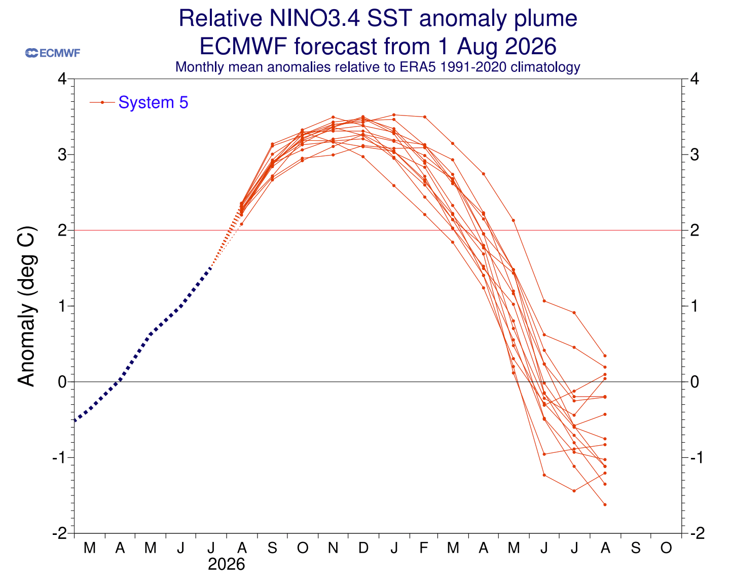
September 2026: Consensus Among Global Models
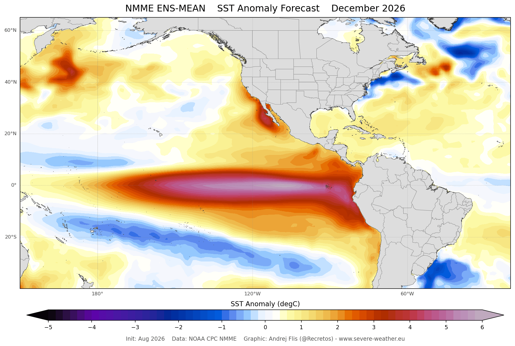
By mid-September 2026, primary global modeling systems—including the ECMWF extended seasonal model and the North American Multi-Model Ensemble (NMME)—achieved high statistical confidence. Their latest runs indicate that the El Niño will peak in late fall or early winter (around December), pushing seasonal anomaly values past the +3°C mark. This alignment allowed meteorologists to roll out the first comprehensive, month-by-month snowfall explorer forecasts for North America and Europe.
Supporting Data: Meteorological Mechanics and Historical Analogs
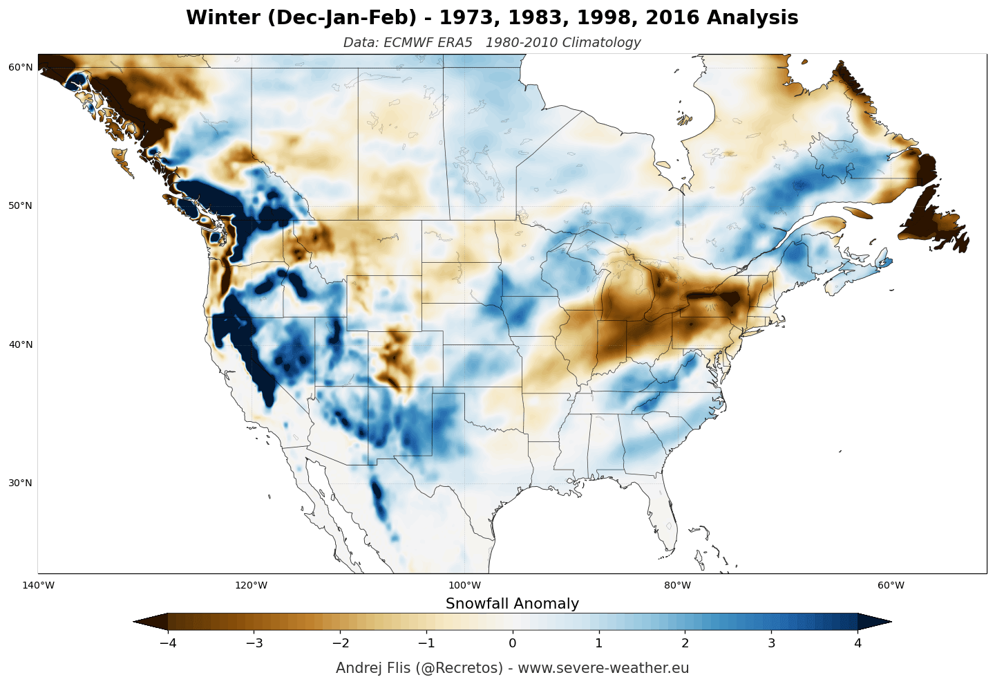
To understand the 2026/2027 forecasts, meteorologists cross-reference current model projections with historical data from past Super El Niño winters—specifically analyzing ERA5 reanalysis composites from the four strongest events on record.
Atmospheric Circulation and Jet Stream Shifts
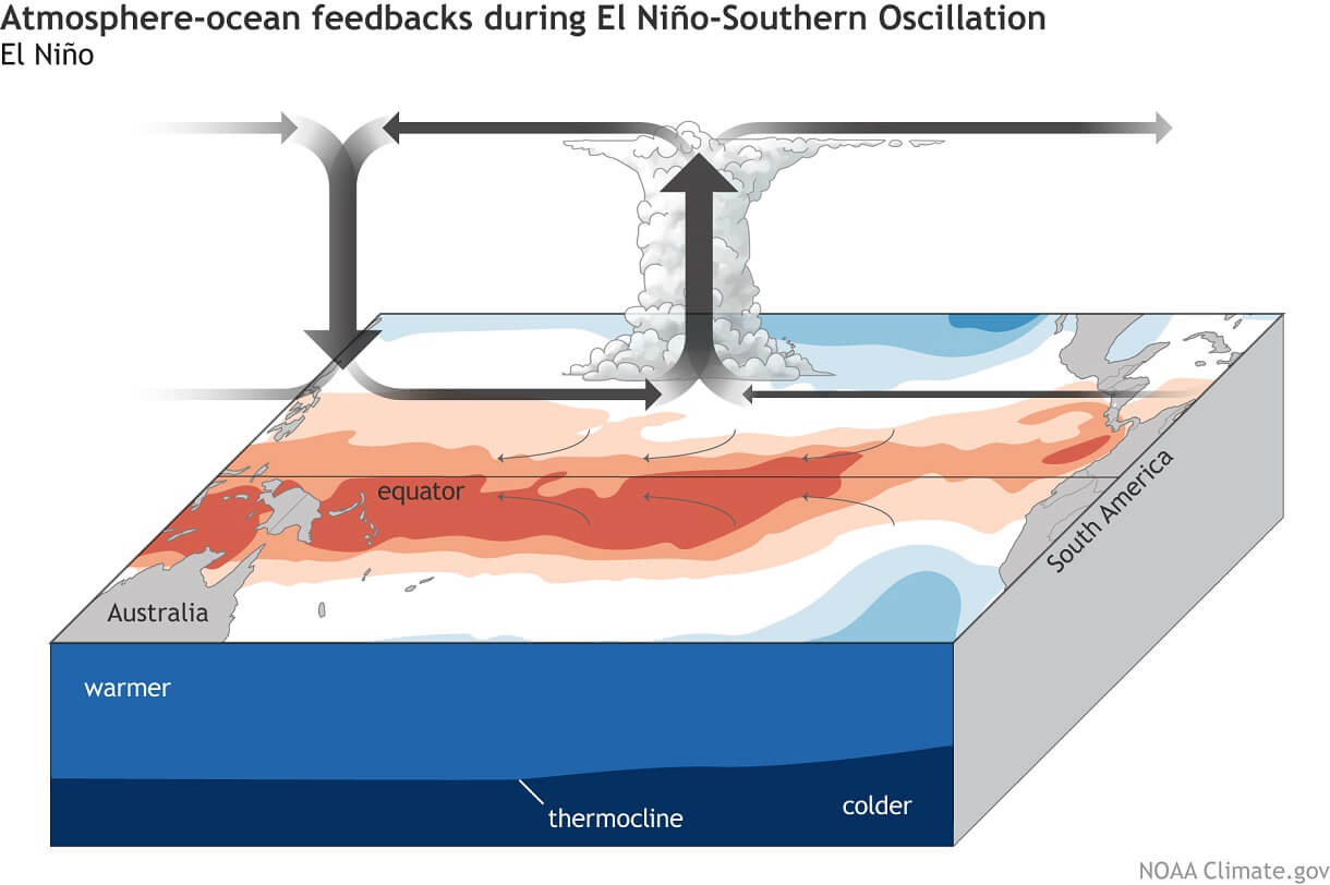
The classic El Niño atmospheric bridge alters the Walker Circulation, causing rising air and lower pressure over the central and eastern Pacific, paired with descending air and high pressure in the western Pacific.
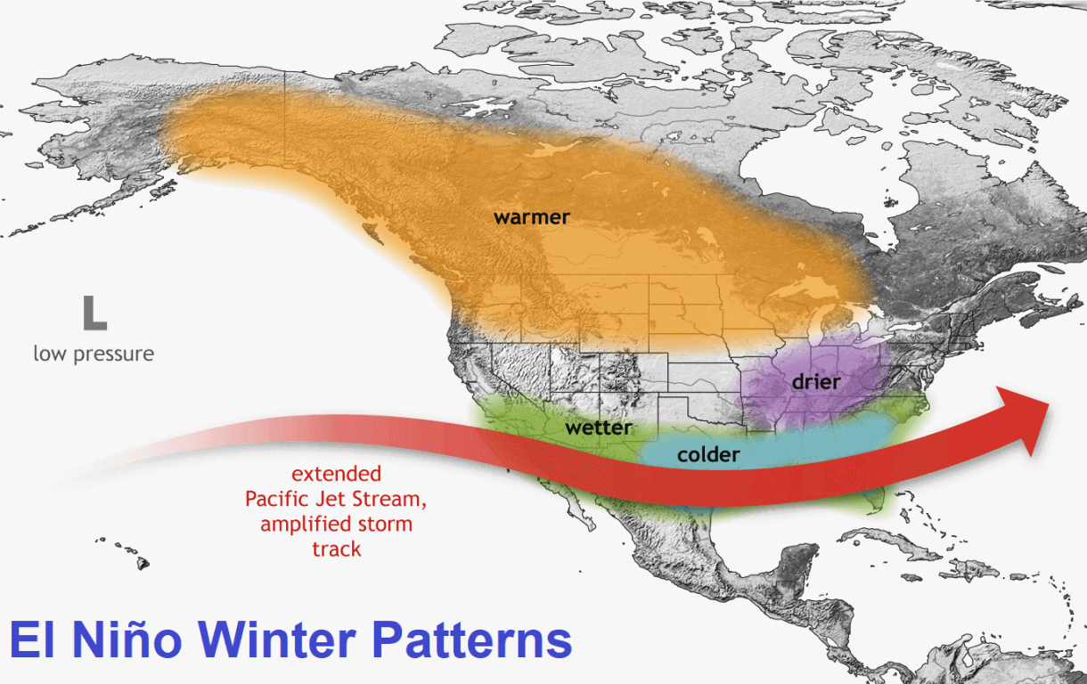
For North America, this manifests as a deep low-pressure zone in the North Pacific paired with a blocking high-pressure ridge over Canada. The resulting amplified southern Pacific jet stream delivers continuous moisture into the southern tier of the United States. When this moisture interacts with periodic cold air intrusions, it primes the Central Plains, Midwest, and East for active winter storm tracks.
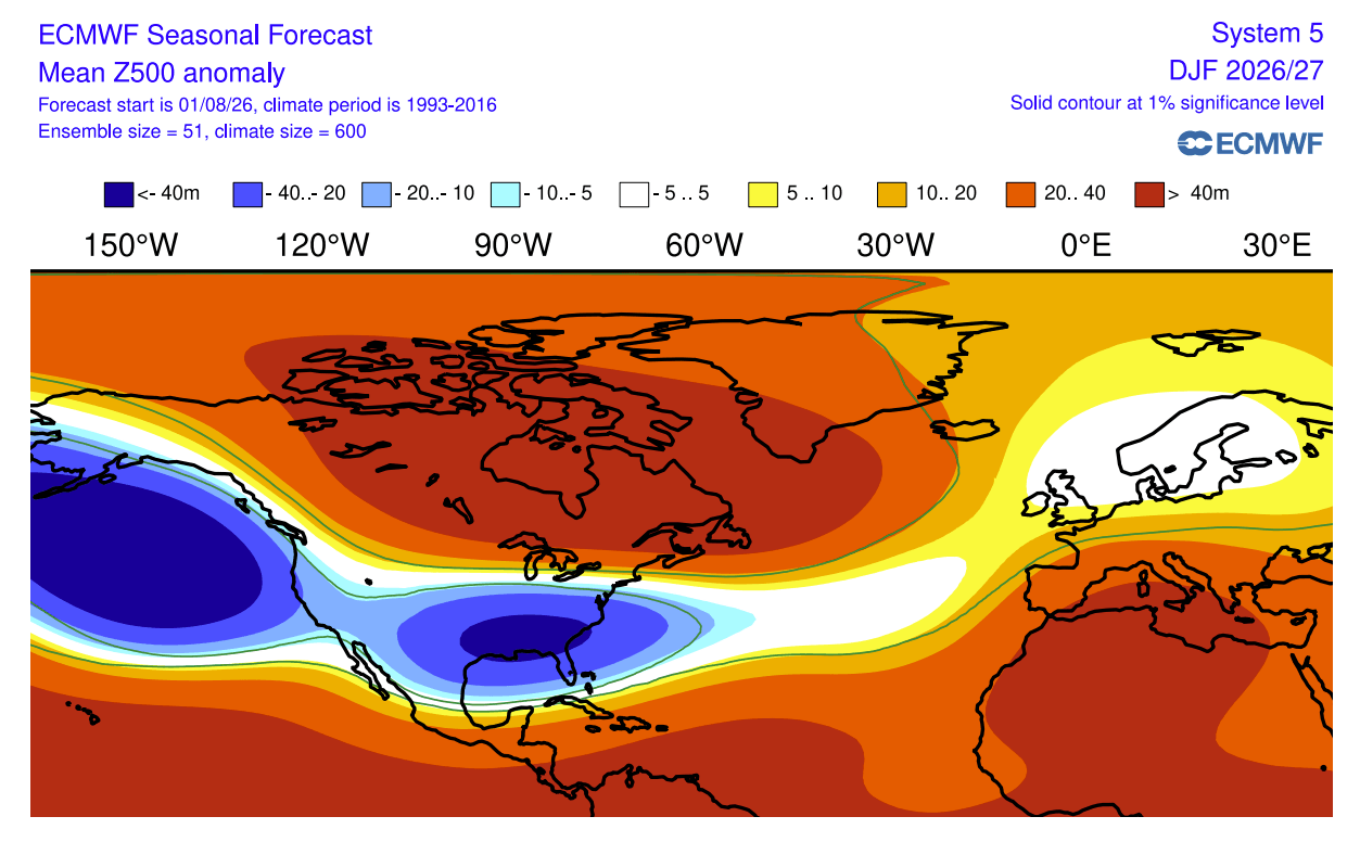
Conversely, the persistent Canadian high-pressure ridge acts as a roadblock for northern storms, diverting the polar jet northward and creating a robust snowfall deficit across the Pacific Northwest, the Great Lakes, the Ohio Valley, and the Northeast.
European Flow Dynamics
For Europe, historical Super El Niño analogs point to a teleconnection driven by a strong pressure gradient between a northern low-pressure system and an expanding southern high-pressure ridge. This configuration establishes a robust, mild westerly flow straight off the Atlantic Ocean, washing out cold air masses and starving European lowlands of natural snowpack.
Official Model Breakdown: ECMWF and UKMO Seasonal Projections
Two premier global forecasting engines—the ECMWF and the UKMO—offer detailed monthly trajectories for the coming winter.
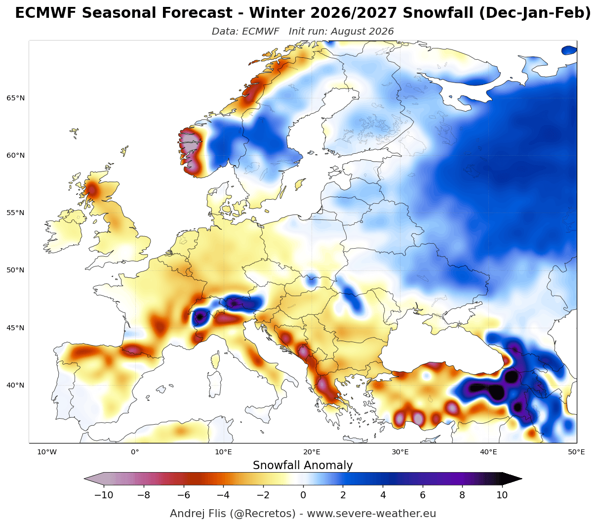
ECMWF European Outlook
The ECMWF seasonal model depicts a bleak picture for European snow enthusiasts.
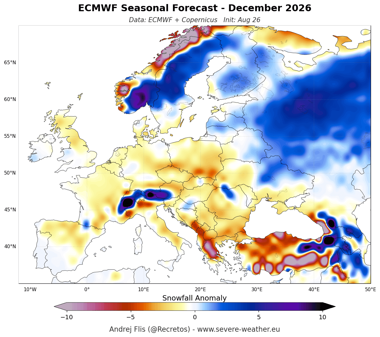
- December: Widespread below-normal snowfall dominates the continent’s lowlands. A strong westerly-to-southwesterly flow brings abundant precipitation, but temperatures remain too high for snow outside of high-altitude alpine regions and the far north.
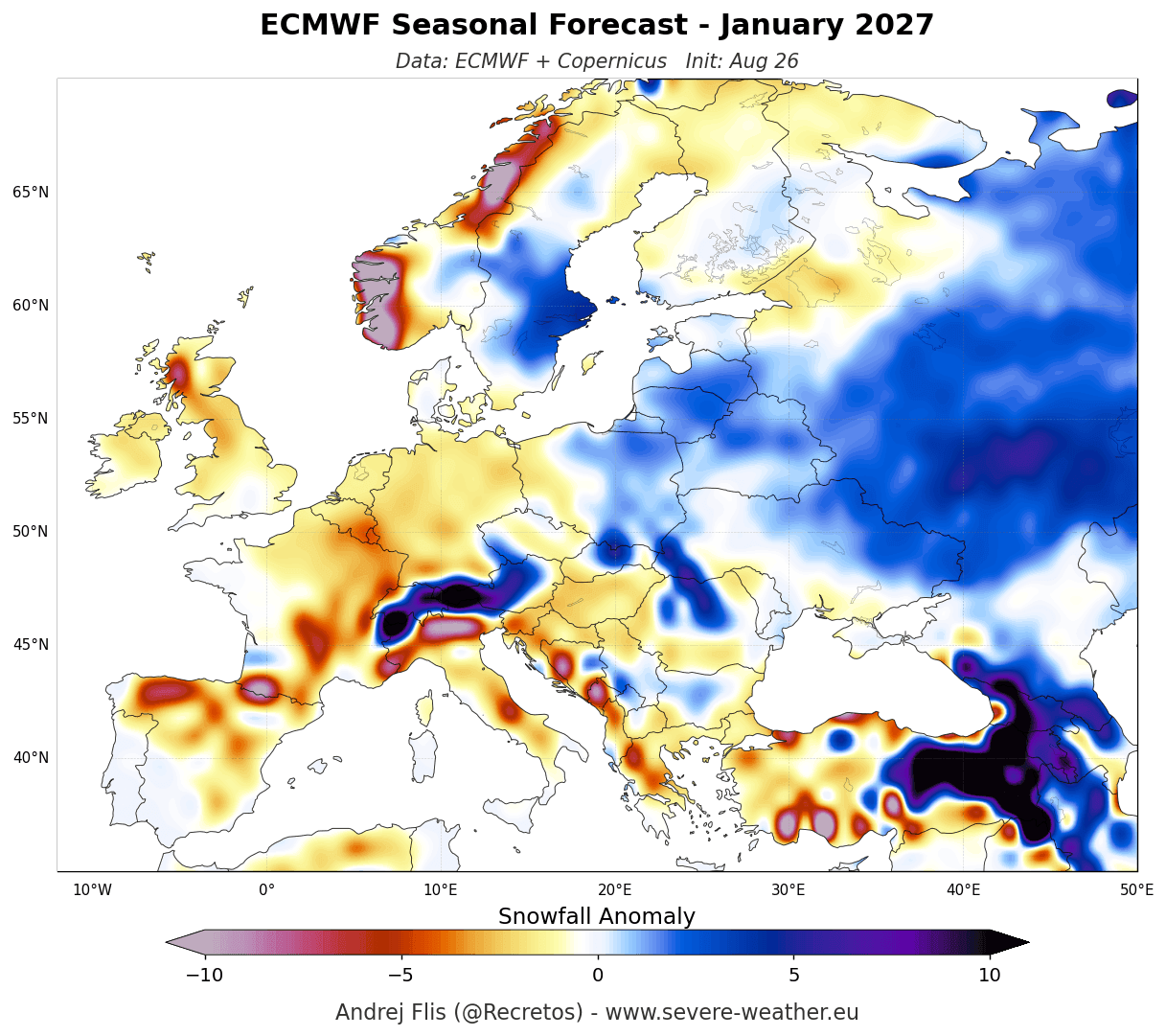
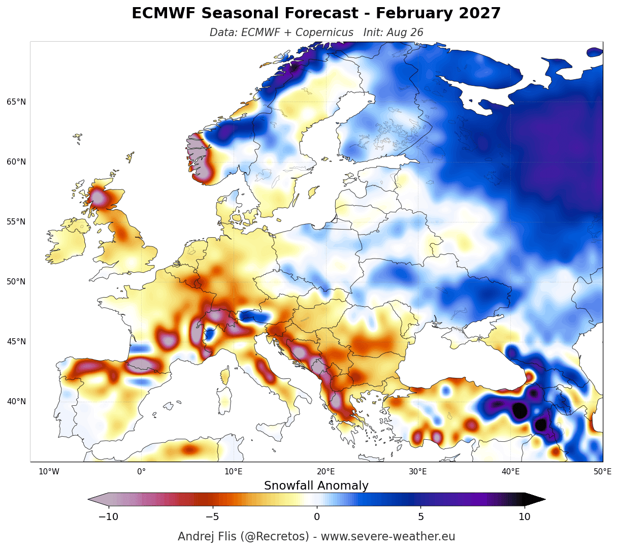
- January & February: The southern high-pressure ridge refuses to budge. Central, western, northwestern, and southern Europe remain locked in negative snow anomalies. Only elevations above 1,800 to 2,000 meters in the Alps—along with northern and northeastern sectors—maintain a favorable snowpack.
ECMWF North American Outlook
North America tells a much more dynamic, fractured story.
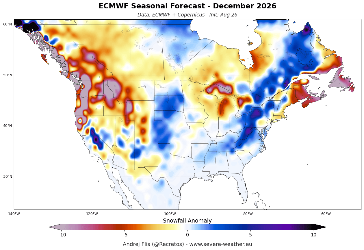
- December: The season starts sluggishly. Increased snowfall potential is confined to the central Plains and parts of the Northeast, while the Great Lakes, Pacific Northwest, and southern Canada experience an early-season snow drought.
- January: Weather patterns shift dramatically. Heavy snowfall anomalies erupt across the Sierra Nevada, the Great Basin, and the central Rockies. Meanwhile, storm tracks push moisture across the southern and central Plains into the Ohio Valley and Mid-Atlantic.
- February: The southern Pacific jet stream hits peak activity. Above-average snowfall blankets a broad zone from the Sierra Nevada and south-central Rockies across the Plains, stretching eastward into the Ohio Valley and Mid-Atlantic. Meanwhile, the northern tier of the U.S. and virtually all of southern Canada remain stuck in a pronounced snow deficit.
- State-Specific Trends (e.g., Texas): Ensemble data for southern states like Texas indicate near-normal snowfall totals through December, followed by a noticeable uptick in January and February, underscoring the southward displacement of the winter storm track.
UKMO Model Agreement
The UK Meteorological Office (UKMO) seasonal runs (covering November through January) closely mirror the ECMWF output, reinforcing confidence in these projections.
- Europe: UKMO projects an even more pronounced delayed start to the European winter, with November and December showing widespread below-average snowfall even at mid-elevations.
- United States & Canada: The UKMO November-to-January mean confirms a classic El Niño footprint. Positive snowfall anomalies are locked into the western and central U.S., tracking eastward into the Ohio Valley, while a broad snow deficit spans from the Pacific Northwest across the northern tier and into southern Canada.
Implications: What Winter 2026/2027 Means for Skiers, Cities, and Industries
The realization of a historic Super El Niño carries significant socio-economic, environmental, and recreational implications across the Northern Hemisphere.
1. The Ski and Winter Tourism Industry
- North America: Ski resorts in California’s Sierra Nevada, Utah, Colorado, Arizona, and New Mexico can breathe a sigh of relief, as they are positioned to benefit from a lucrative, snow-rich winter. However, resorts in the Pacific Northwest, the Midwest, and the Northeast will need to lean heavily on snowmaking capabilities, particularly during the early-to-mid winter months.
- Europe: European ski operators face a challenging season. Resorts outside of high-altitude glacial terrain or elevations exceeding 2,000 meters in the Alps face a high risk of poor natural snow cover, threatening regional winter tourism economies.
2. Municipalities and Infrastructure
- Southern and Eastern U.S.: Cities situated along the path of the active southern storm track—ranging from the southern Plains to the Mid-Atlantic—must prepare for potentially disruptive mid-to-late winter storm events. While these regions will see above-normal snowfall relative to their historical averages, municipal budgets may be strained by sudden, heavy accumulations that they are less routinely equipped to clear compared to northern counterparts.
- Northern U.S. and Canada: Conversely, municipal snow-removal budgets in the northern Plains, the Great Lakes, and southern Canada may experience significant financial surplus due to reduced salting and plowing requirements, though lower snowpack levels could impact spring and summer watershed replenishments.
3. Agriculture and Hydrology
The divergence in snowpack distribution will have lasting hydrological consequences. The heavy snowpack accumulating in the Western U.S. mountains will provide essential spring meltwater for drought-prone river basins in the West and Southwest. At the same time, diminished snowpack in parts of the Pacific Northwest and southern Canada could raise early concerns regarding seasonal soil moisture and summer water resource management.
As meteorological agencies continue to refine data heading deeper into autumn, forecasters advise monitoring localized updates. While seasonal anomalies provide a reliable macro-level roadmap for Winter 2026/2027, day-to-day weather will inevitably feature short-term atmospheric variability.
