

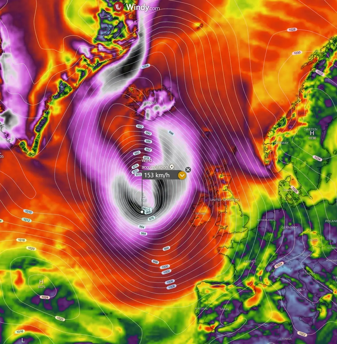
DUBLIN/REYKJAVÍK — Western Europe and the North Atlantic are bracing for a severe meteorological onslaught this week as a rapidly intensifying "bomb cyclone" takes shape off the coast. Powered by an energetic upper-level trough clashing with a stubborn blocking high-pressure system, the developing weather engine is forecast to plunge in central pressure below 950 mbar.
The storm’s vast circulation will sweep across the British Isles, Ireland, the Faroe Islands, and Iceland, bringing with it a cocktail of hurricane-force wind gusts, towering maritime swells up to 12 meters, unseasonably warm air plumes, and catastrophic, orographic rainfall.
Meteorological agencies have raised alerts as the system undergoes explosive cyclogenesis over the North Atlantic, threatening hazardous travel, structural damage, and widespread coastal flooding.
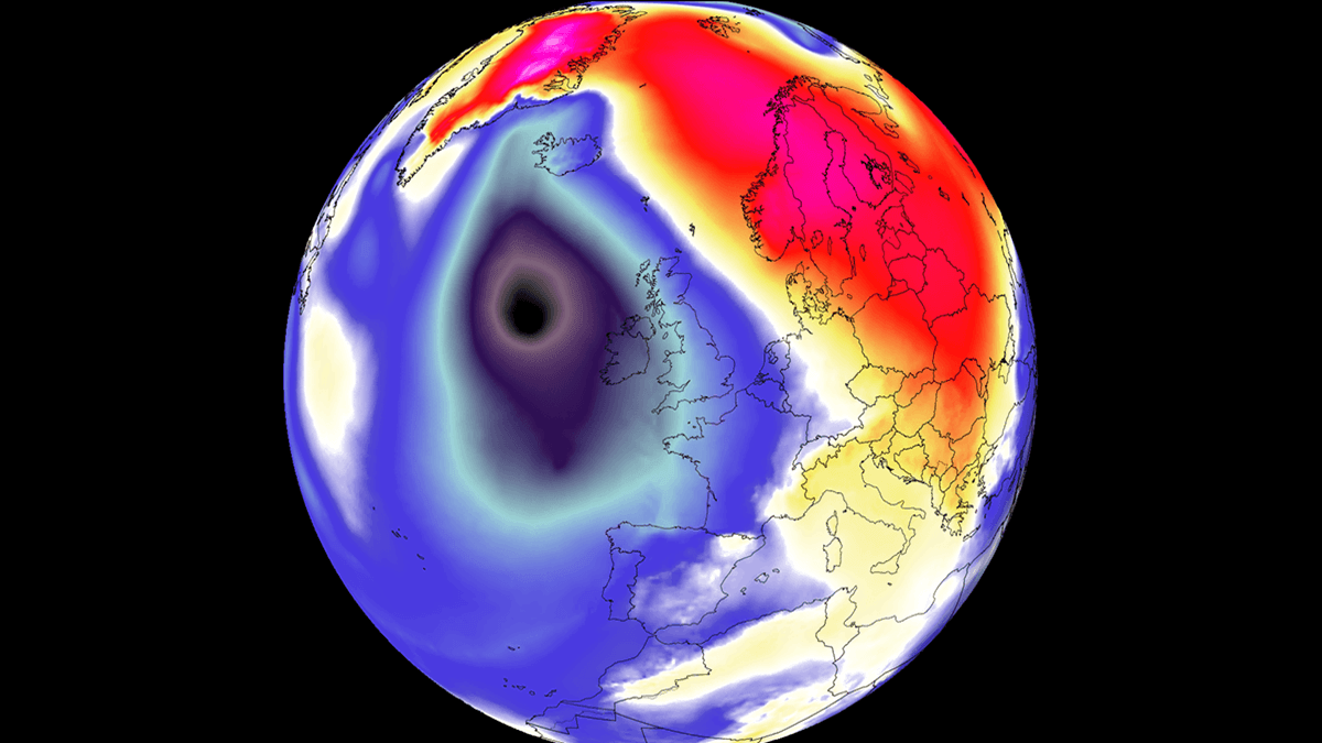
Main Facts: The Anatomy of an Atlantic Bomb Cyclone
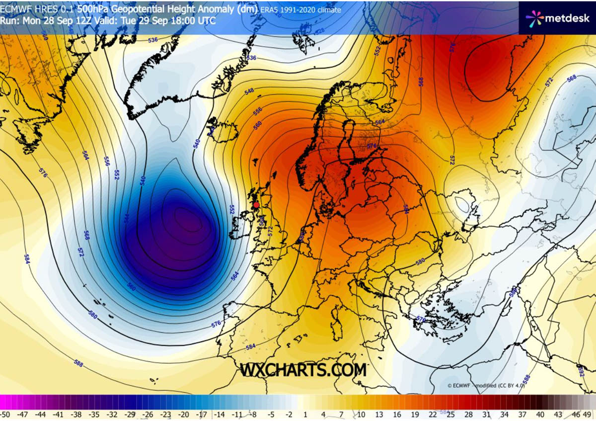
The impending weather crisis is the result of a classic, high-amplitude baroclinic setup. A vigorous upper-level trough swinging out of the North Atlantic is colliding head-on with a sprawling 1035 hPa blocking high-pressure system firmly anchored over Central Europe and Scandinavia.
This stark pressure contrast—or steep baroclinic gradient—is aggressively squeezing isobars across the United Kingdom and Ireland. The resulting pressure field is unleashing severe gale-to-storm-force winds, intense squall lines, and monumental Atlantic swells.
Meteorologists classify the system as a "bomb cyclone" due to the velocity of its intensification. In meteorological terms, bombogenesis occurs when a mid-latitude storm’s central barometric pressure plummets by more than 24 millibars (mbar) within a 24-hour window.
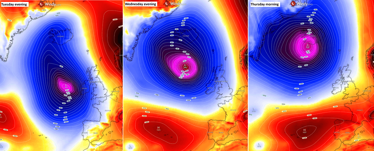
- Pressure Drop: The system’s core pressure is projected to crash from approximately 990 mbar on Monday evening down to near 965 mbar by Tuesday evening, before diving below the staggering 950 mbar threshold by Wednesday midday.
- Peak Winds: Areas nearest the low-pressure core could experience wind gusts surpassing 150 km/h, while widespread peak gusts of 100 to 130 km/h batter Ireland, Northern Ireland, Scotland, and Western England.
- Marine Hazards: Atlantic-facing shores are preparing for colossal wave heights of 8 to 10 meters, with open-ocean swells reaching an imposing 10 to 12 meters to the west of Ireland and Scotland.
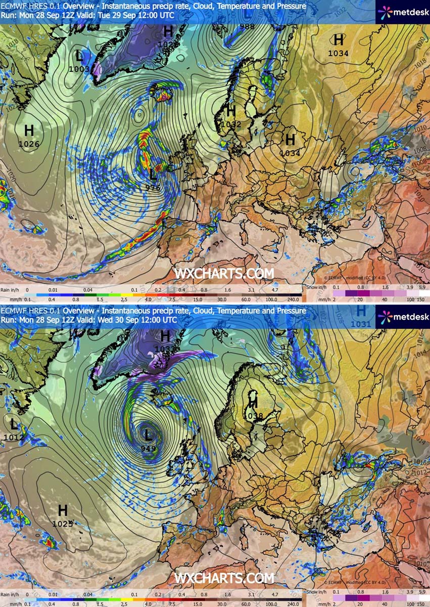
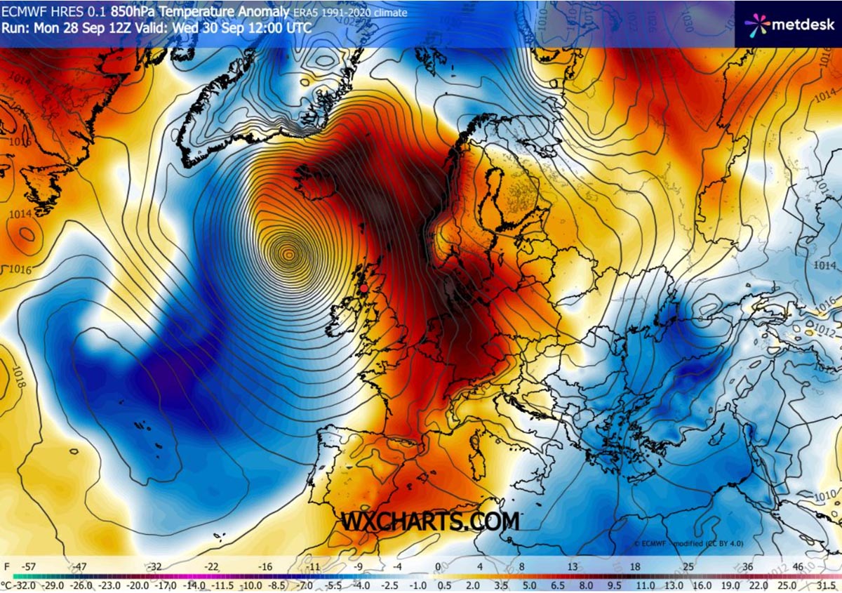
- Thermal Anomalies: A powerful southerly jet stream on the system’s eastern flank is pumping a warm, anomalous air mass far north toward Scandinavia, Denmark, and Iceland, triggering localized heavy rainfall and unseasonably mild temperatures.
Chronology of the Storm: From Genesis to Landfall
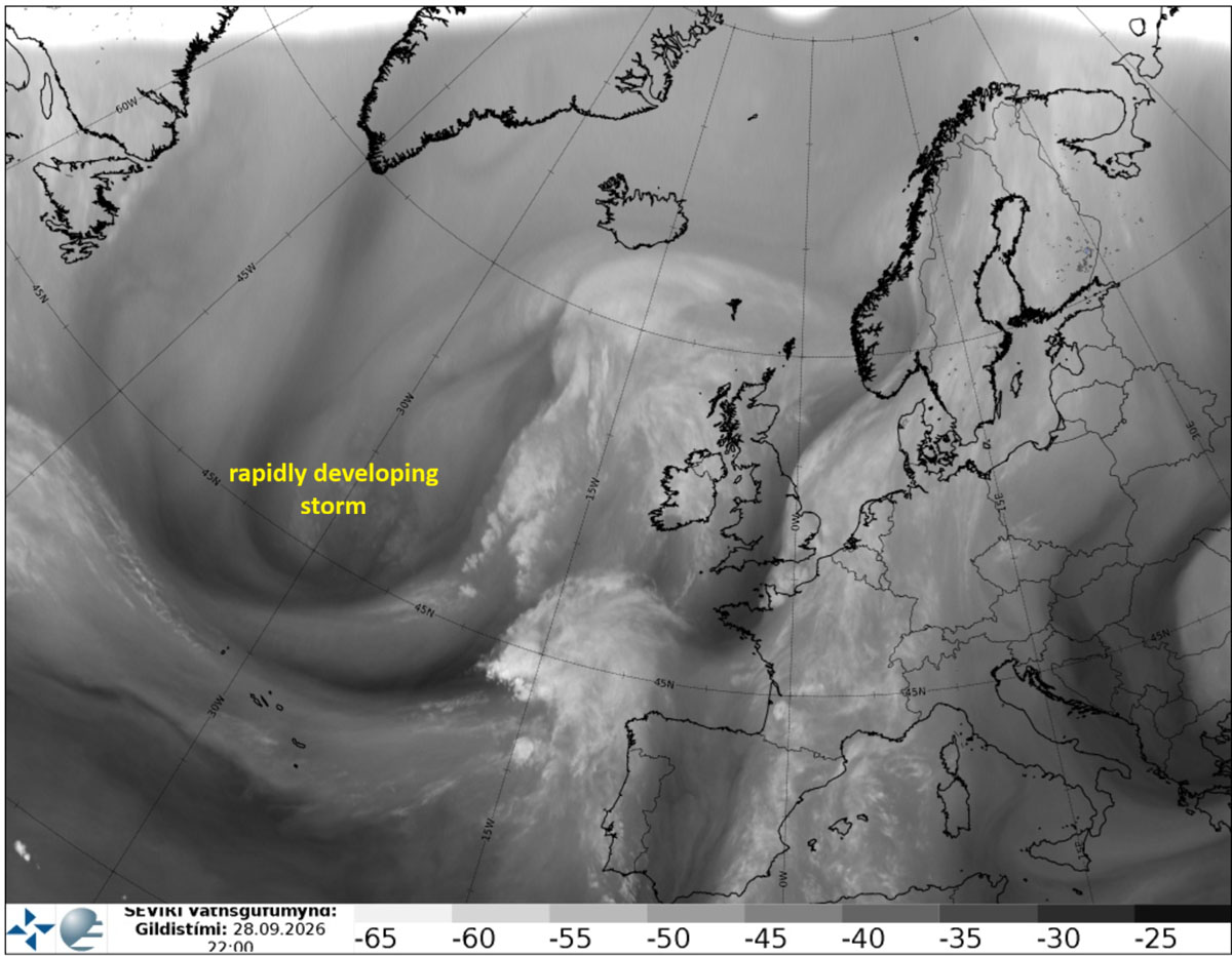
The life cycle of this severe windstorm began taking distinct shape over the North Atlantic early this week, captured vividly by satellite water vapor imagery that highlighted an aggressive jet stream and a robust baroclinic zone.
Monday: The Genesis and Initial Intensification
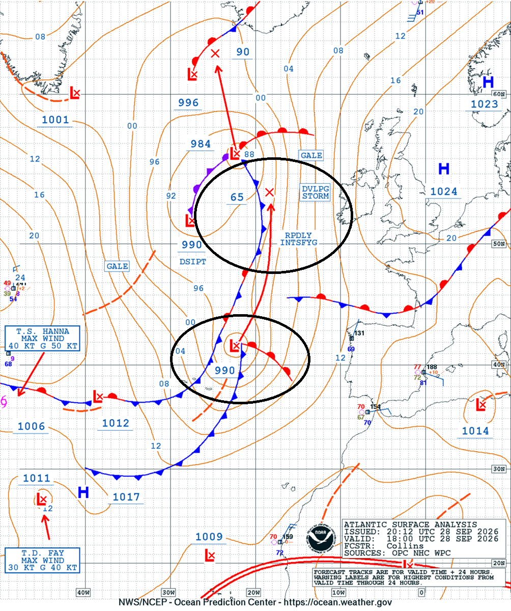
By Monday night, analysis from the Ocean Prediction Center (OPC) confirmed the emergence of a potent wave west of the Iberian Peninsula. Tracking aggressively northward, the system exhibited clear signatures of rapid deepening. Initial surface charts demonstrated that the low was beginning its transition into a bomb cyclone, setting the stage for a dangerous mid-week trajectory.
Tuesday: Direct Impacts on Ireland and the UK
As the system organizes on Tuesday morning and approaches Western Europe, its central pressure continues to tumble. Met Éireann responded by issuing yellow weather warnings for coastal regions of Ireland and Northern Ireland.
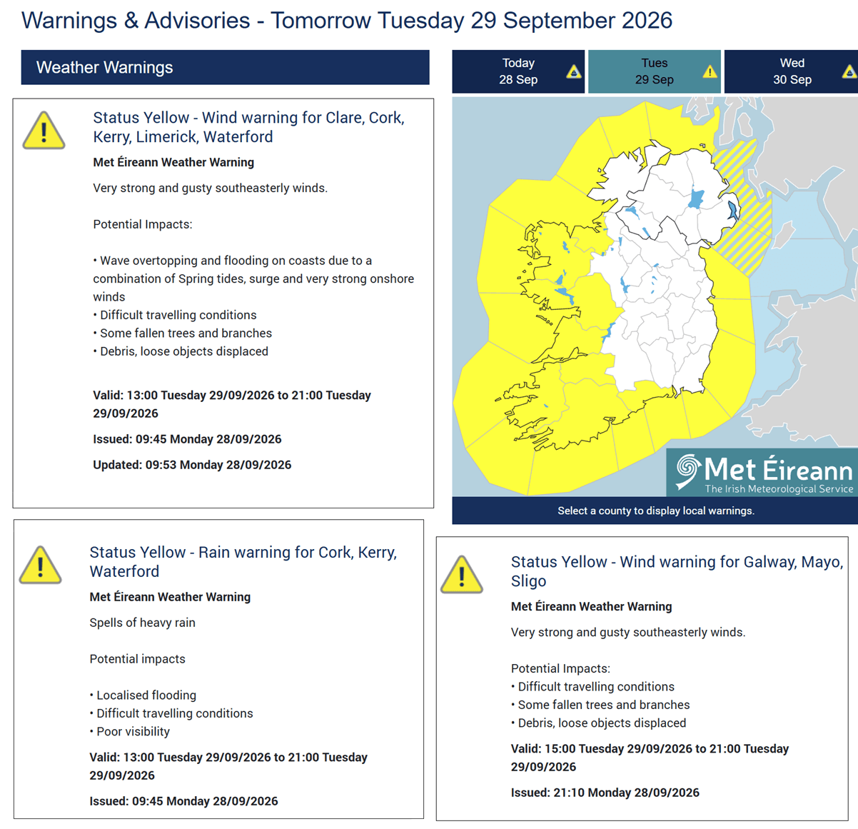
By Tuesday afternoon and evening, a fast-moving surface cold front is tracking east across Ireland, Northern Ireland, and Scotland. This frontal passage brings sudden rain squalls and hazardous, gusty winds capable of causing difficult driving conditions, localized flooding, and falling trees. Gale-force winds are lashing the western coasts of Ireland and the Scottish Outer Hebrides.
Wednesday: Peak Maturity and Hurricane-Force Core
By Wednesday midday, the storm reaches its explosive maturity. The central pressure bottoms out below 950 mbar (approaching 945 mbar), creating a suffocatingly tight pressure gradient around its core. Near hurricane-force winds buffet the open ocean and threaten the Faroe Islands.
Concurrently, the expansive warm plume wraps around the eastern side of the system, delivering unusually high temperatures to Northwestern Europe. However, as the storm tracks further north, its moisture-laden southern flank begins slamming into Iceland, initiating a prolonged heavy precipitation event.
Thursday: Landfall in Iceland and Weakening
Moving rapidly north-northwest, the center of the deep Atlantic storm makes a direct approach toward Iceland by Thursday morning. While the system slowly begins to weaken as it moves ashore, its relentless fetch unleashes torrential orographic rainfall and severe gale-force winds across the island nation before the system finally dissipates later in the week.
Supporting Meteorological Data and Analysis
Advanced numerical weather prediction models and satellite diagnostics provide a clear window into the immense physical scale and severity of this weather event.
Surface Fronts and Omega Blocks
The broader European weather pattern features an Omega blocking configuration over the continent, forcing the deep Atlantic low to carve a sharp, northerly route. Surface-front forecasts outline a potent cold front sweeping swiftly across the British Isles on Tuesday, followed by a vertically stacked, highly intense low-pressure center by Wednesday.
Temperature Anomalies at 850 mbar
At the 850 mbar pressure level—roughly 1,500 meters above the surface—the temperature anomaly charts highlight a pronounced warm-air advection tongue streaming northward. Western Europe, the North Sea basin, and areas toward the Faroe Islands and Denmark will experience notably above-average temperatures ahead of the cold front, contrasting sharply with the raw, wind-driven conditions behind it.
Wave Action and Maritime Threat
The sheer fetch and duration of the southerly and westerly gales will generate extreme sea states. Significant wave height models indicate that open waters west of Ireland and Scotland will witness towering 10 to 12-meter waves between Tuesday afternoon and Thursday. Coastal communities facing the Atlantic must remain vigilant against severe wave overtopping, coastal erosion, and localized marine inundation.
Rainfall and Atmospheric River Dynamics
While rainfall totals associated with the fast-moving cold front across Ireland and the UK will remain relatively manageable, the situation in Iceland is entirely different.
Beginning Wednesday afternoon and lasting through Thursday, a persistent south-southeasterly jet stream will establish an atmospheric river. This setup will direct continuous, moisture-rich air straight into the high terrain of southern and southeastern Iceland. Orographic lifting will squeeze out massive quantities of rain, with localized accumulations forecast to reach an extraordinary 250 to 300 mm (or higher), raising the immediate threat of flash flooding and landslides.
Official Responses and Public Safety Advisories
National meteorological services and civil defense authorities across the affected zones have mobilized in response to the developing bomb cyclone.
- Ireland: Met Éireann has instituted yellow wind and rain warnings for western and northern coastal counties. Authorities have urged motorists to exercise extreme caution on roads due to the high risk of flying debris, tree branches, and sudden localized surface flooding. Public transport providers have warned of potential delays and cancellations as high-profile vehicle restrictions come into effect on exposed bridges and viaducts.
- United Kingdom: Met Office forecasters are monitoring the trailing squall lines and gust swaths impacting Scotland and Western England. Local councils have been placed on standby to clear blocked drains and respond to downed power lines.
- Iceland: With catastrophic rainfall totals anticipated, the Icelandic Meteorological Office (Veðurstofa Íslands) and civil protection teams are preparing for severe hydrological impacts. Residents in southern and southeastern catchments have been advised to secure outdoor property, clear drainage systems near homes, and avoid unnecessary mountain travel as rivers swell rapidly.
- Maritime Authorities: Coast guards and port authorities across Ireland, the UK, and the North Atlantic have issued severe gale warnings for commercial shipping and fishing fleets, advising vessels to seek safe harbor well in advance of the peak 12-meter swells.
Socioeconomic and Environmental Implications
Severe windstorms of this magnitude carry wide-ranging implications for infrastructure, agriculture, and local ecosystems across Western Europe.
Infrastructure and Energy Grids
The combination of sustained gale-force winds and saturated soils creates a high-risk environment for overhead power lines. Trees weakened by seasonal changes or root stress are exceptionally vulnerable to uprooting during peak wind gusts of 130 to 150 km/h. Power distribution companies in Ireland, Scotland, and Northern Ireland have placed repair crews on emergency alert to handle anticipated localized blackouts.
Transportation and Commerce
Aviation, maritime, and rail networks face significant disruption. High winds routinely force speed restrictions on rail lines and ground cross-wind-sensitive regional flights. Meanwhile, major ferry crossings across the Irish Sea and North Atlantic face suspension as towering wave heights render maritime transit hazardous.
Agricultural and Hydrological Impacts
In Iceland, the sheer volume of rain delivered by the atmospheric river threatens agricultural lowlands with severe waterlogging and riverine flooding. Conversely, the unseasonably warm air advection across parts of Western Europe may provide a brief thermal reprieve for crops, though windburn and salt spray deposition from high-velocity coastal gales could damage sensitive coastal vegetation.
Climate and Seasonal Context
Coming during a period already marked by remarkable global climate anomalies—such as the record-breaking developments associated with the ongoing 2026 El Niño cycle—this powerful bomb cyclone underscores the dynamic and often volatile nature of autumnal transition seasons in the North Atlantic basin.
Safety Reminder
Residents and travelers across Ireland, the UK, the Faroe Islands, and Iceland are strongly urged to monitor real-time updates from official national weather services via platforms such as Windy, Vedur IS, and Wxcharts as this violent meteorological event unfolds. Stay safe and avoid coastal promenades during peak swell periods.
