

Main Facts: A Massive Upper-Level Ridge Locks Extreme Heat in Place
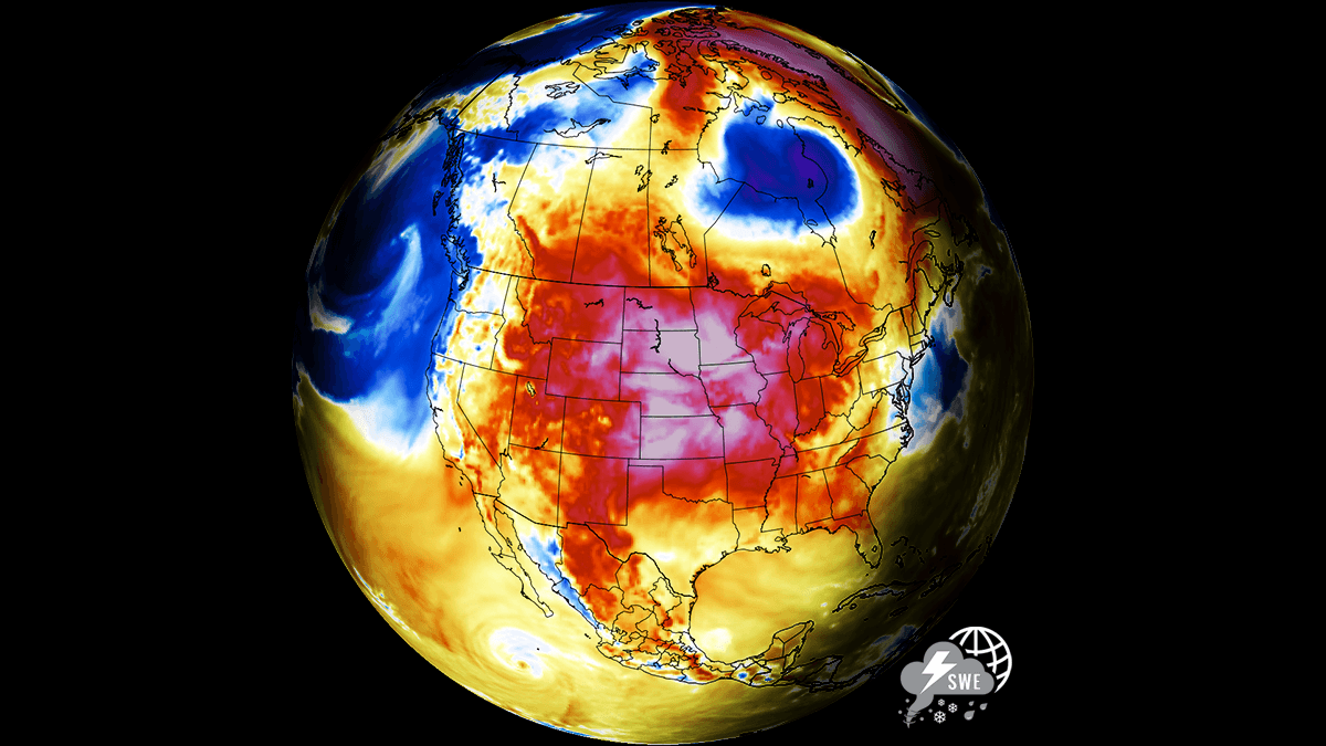
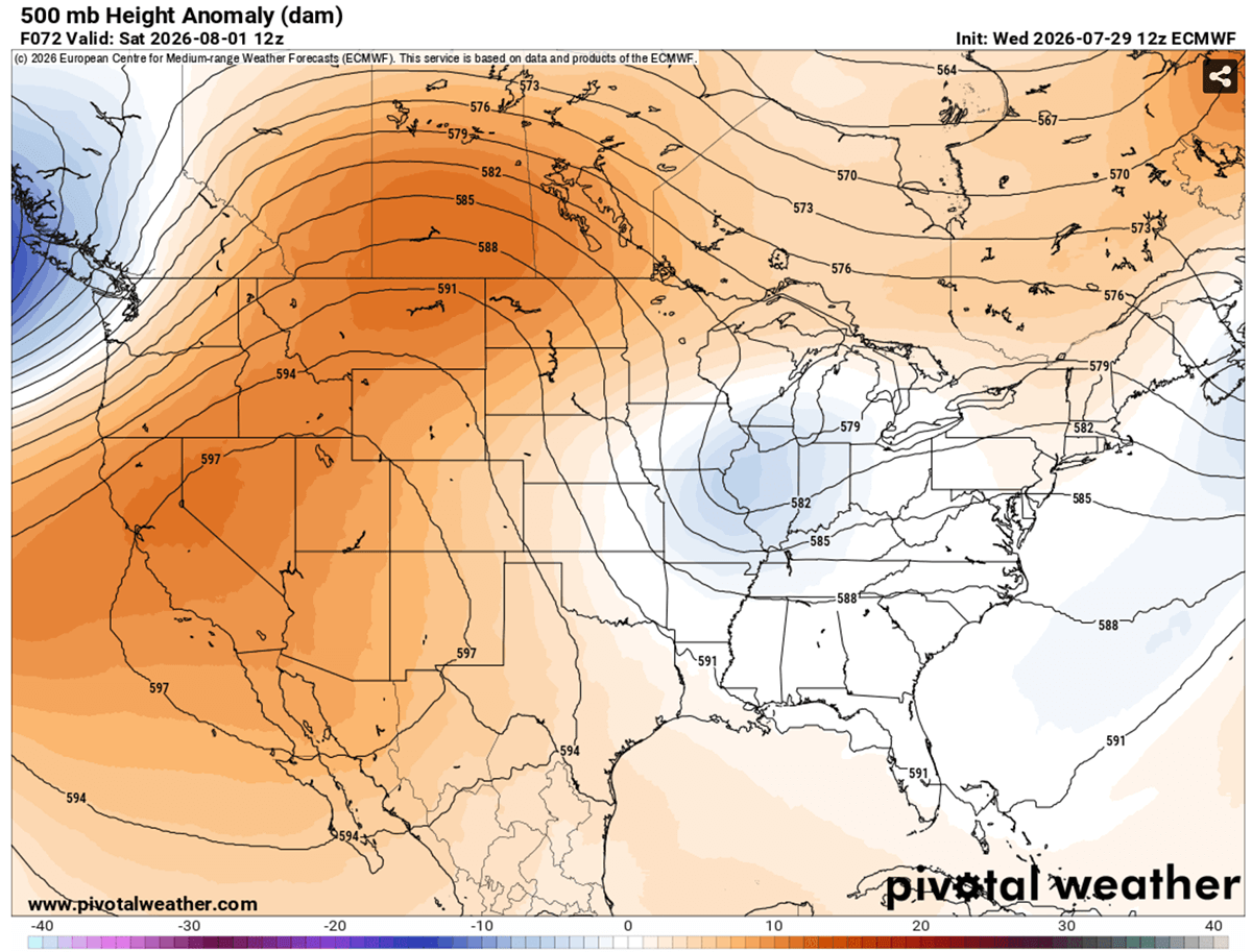
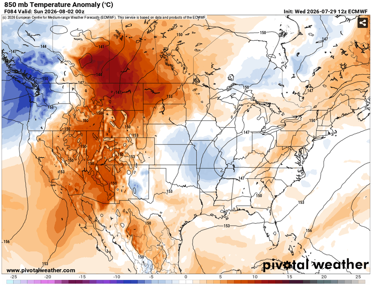
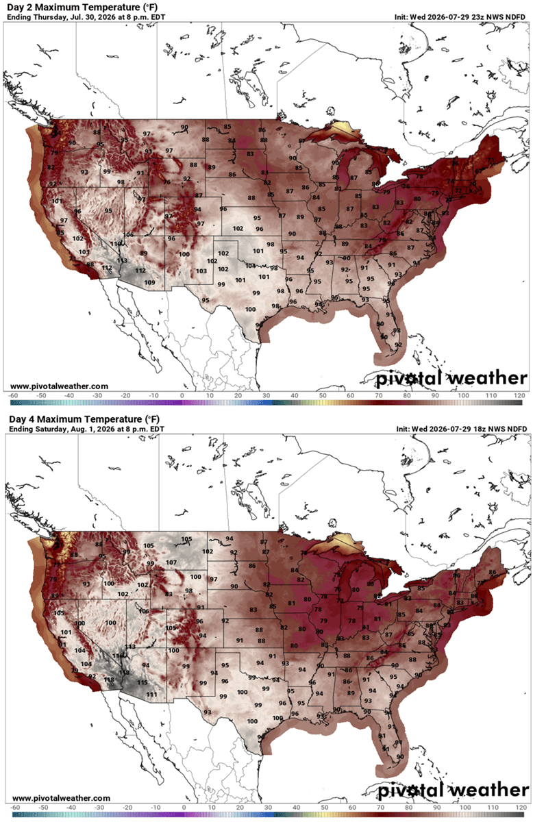
A high-amplitude, persistent upper-level ridge has locked a massive Heat Dome across the United States and parts of southern Canada, triggering a prolonged and potentially historic stretch of dangerous summer weather. As the calendar turns toward early August, this intense high-pressure system is sending upper-air thermal anomalies soaring into the 99th percentile. Peak afternoon temperatures are projected to surge well past 105°F to 110°F across the Southwest, the Great Basin, and the central plains.
Desert basins are facing the most punishing impacts, where daytime highs are expected to reach a blistering 115°F to 120°F. Meanwhile, major urban corridors face compounded physiological stress as overnight lows struggle to drop below a stifling 75°F to 80°F.
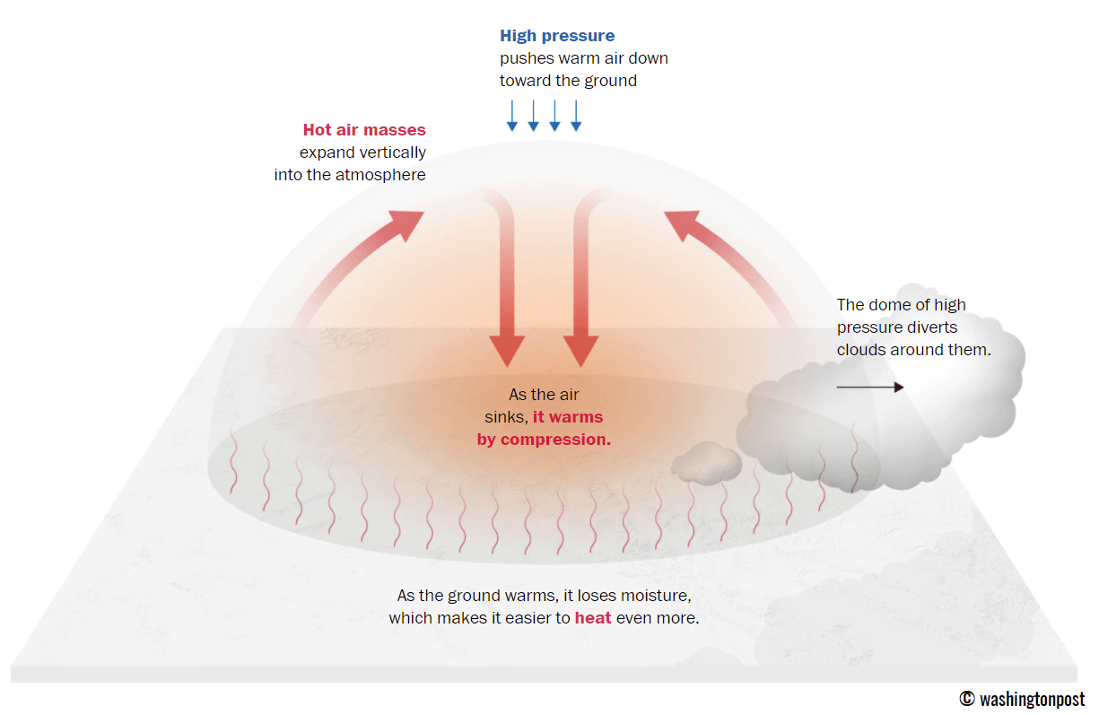
The phenomenon is driven by deep atmospheric compression. Operating much like the lid on a boiling pot of water, the stationary high-pressure system traps a massive volume of warm air at all levels. As atmospheric layers slowly sink toward the surface, they compress and heat up rapidly, creating a severe thermal blanket that extends from Southern California across the Great Plains and up into the Mississippi Valley, as well as portions of the Canadian provinces of Alberta and Saskatchewan.
Beyond the immediate human toll, this multi-week thermal spike is rapidly accelerating soil moisture depletion across major agricultural belts, threatening crops just as they enter critical late-summer developmental stages. Power grids are also experiencing unprecedented strain as residential and commercial air conditioning demand skyrockets.
Chronology: The Evolution of the August Heat Event
Mid-Week Buildup: The Ridge Takes Shape
The synoptic setup began taking form earlier in the week as a robust upper-level ridge anchored itself firmly over the Western United States and the Northern Rockies, slowly expanding its influence toward southern Canada. Simultaneously, a shallow low-pressure system began tracking eastward from the mid-Mississippi Valley toward the Southeast, leaving the central and western sectors of the continent entirely at the mercy of the expanding atmospheric block.
As the subsiding air mass took hold under the core of the ridge, surface temperatures quickly escalated. Readings pushed into the mid-90s to near 100°F across several western and central states, setting the stage for a dramatic weekend intensification.
The Peak: Thursday Through Saturday Extremes
The heat dome reached an initial critical peak between Thursday and Saturday. Across the Great Plains, afternoon highs climbed into the upper 90s to 103°F, with the most severe conditions concentrated from Texas through Oklahoma and into Kansas.
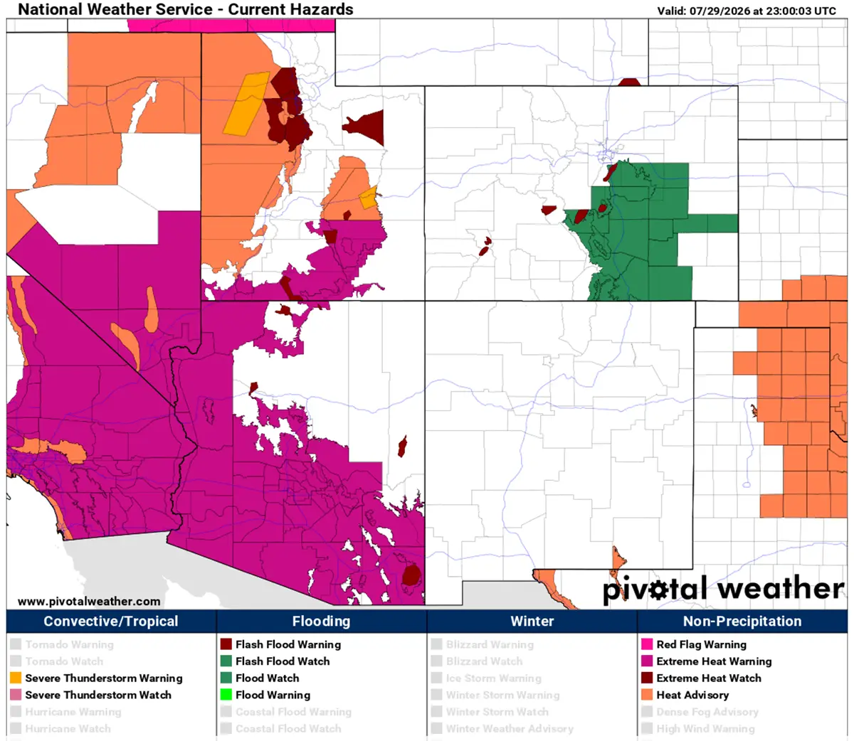
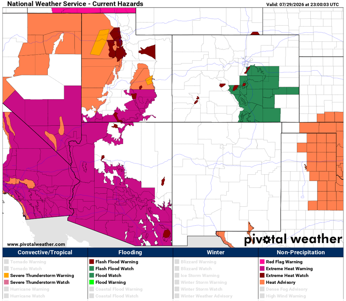
By Saturday, the dome aloft reached its maximum intensity over the northern tier. Montana, Wyoming, and the western Dakotas experienced staggering afternoon peaks ranging from 103°F to nearly 110°F. Meanwhile, the desert Southwest continued to bake under unforgiving sunshine, recording daytime highs between 112°F and 120°F in valley locations.
Sunday and Monday: Shifting Cores and Ongoing Strain
The dangerous heat wave persists into Sunday and Monday, carrying deep into early August. Sunday’s forecasts show daytime peaks holding steady in the upper 90s to low 100s across the Plains from Texas to the Dakotas, while Arizona, Nevada, and California remain trapped under extreme 115°F to 120°F readings.
By Monday, the core of the hottest air mass is expected to shift slightly, focusing its intensity over the central and southern Plains. New Mexico, Texas, and the Colorado High Plains will bear the brunt of this phase, with afternoon peaks consistently hitting 100°F to 105°F.
Relief in Sight: Mid-Week Breakdown
Global weather models indicate that a significant pattern shift is on the horizon. A robust frontal system originating in Canada is projected to push eastward early next week, bringing a cooler air mass down into the northern High Plains by Wednesday. This expected influx of refreshing air should finally break the multi-week grip of the northern heat dome, though southern and western regions may retain elevated temperatures longer.
Supporting Data: Understanding the Atmospheric Mechanics and Heat Indices
To fully grasp the severity of this weather event, meteorologists look closely at a combination of upper-air anomalies, surface temperature charts, and human-centric heat indices.
The Science of the Heat Dome
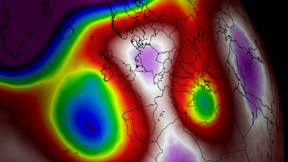
A heat dome is sustained by an "Omega block" or a stationary blocking high. When a broad area of high-pressure air parks over a large portion of a continent for several days or weeks, it suppresses cloud formation and maximizes solar radiation reaching the ground.
- 850 hPa Thermal Anomalies: Meteorologists track temperatures at the 850 millibar level (roughly 5,000 feet above sea level) to evaluate air mass warmth without interference from surface boundary-layer quirks. Current anomalies associated with this dome are resting firmly in the 99th percentile, indicating an air mass that is historically hot for early August.
- Subsidence and Compression: As air sinks from the upper troposphere toward the surface, it undergoes adiabatic compression. This physical process forces air molecules closer together, raising the kinetic energy and translating into scorching surface temperatures.
The Heat Index Factor: Humidity Amplifies Danger
Temperature alone does not tell the full story of human vulnerability during a heat dome. Relative humidity plays a critical role in how the human body cools itself through perspiration.
The Heat Index calculates the combined effect of ambient air temperature and relative humidity to reflect what the air actually "feels" like to the human body. For instance:
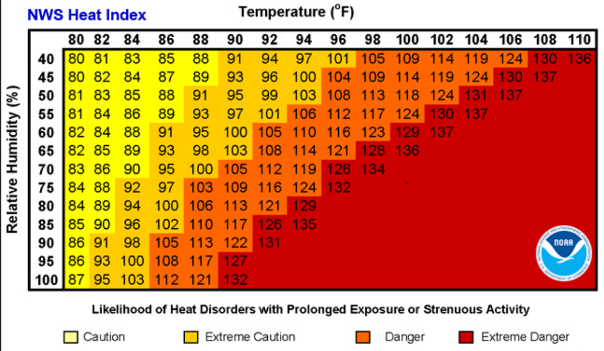
- An air temperature of 90°F with low humidity (below 60%) presents a manageable physiological challenge.
- The same 90°F temperature combined with high humidity (above 80%) drives the perceived heat index up to a staggering 113°F.
When high humidity coincides with elevated daytime temperatures and a lack of overnight cooling, the risk of heat-related illnesses increases exponentially.
Official Responses: Managing Public Health and Grid Stability
Public health officials, emergency management agencies, and grid operators across the United States and Canada have mobilized comprehensive responses to mitigate the dangers posed by the prolonged heat dome.
Health Advisories and Vulnerable Populations
National Weather Service offices have issued widespread Excessive Heat Warnings and Heat Advisories spanning multiple states. Officials are placing special emphasis on protecting vulnerable populations, including:
- The Elderly and Children: Physiological responses to rapid temperature changes are less efficient in the very young and the elderly, making them prime candidates for heat exhaustion and heat stroke.
- Outdoor Workers: Construction workers, agricultural laborers, and maintenance crews face severe occupational hazards. Regulatory bodies are urging employers to implement mandatory hydration breaks, shaded rest areas, and altered shift hours to avoid peak solar radiation periods.
- Low-Income Urban Communities: Urban heat island effects—where concrete, asphalt, and dense housing materials absorb and re-emit heat long after sunset—create life-threatening indoor conditions, particularly for residents lacking adequate air conditioning.
Medical professionals remind the public that heat exhaustion (characterized by heavy sweating, weakness, dizziness, and nausea) can quickly escalate into heat stroke—a medical emergency defined by a core body temperature above 103°F, confusion, and loss of consciousness. Heat waves are also historically correlated with spikes in heart attacks, strokes, and acute respiratory distress.
Energy Grid Management
With residential and commercial air conditioning units running continuously to combat the relentless heat, power grid operators—such as the Electric Reliability Council of Texas (ERCOT) and regional transmission organizations across the West and Midwest—have issued calls for energy conservation. Consumers are being asked to voluntarily adjust thermostats upward by a few degrees during peak afternoon hours (typically 2:00 PM to 8:00 PM) to prevent rolling blackouts and protect electrical infrastructure from thermal overload.
Implications: Agriculture, Infrastructure, and Climate Trends
The ongoing heat dome carries profound long-term implications for the affected regions, touching upon agricultural viability, civil engineering, and broader climatic patterns.
Agricultural Stress and Soil Depletion
The combination of record-breaking heat and lack of meaningful precipitation is rapidly depleting soil moisture across major agricultural corridors in the U.S. Great Plains and western Canada. Rainfed crops, particularly corn and soybeans during their critical grain-fill stages, are facing severe heat stress and potential yield reductions. Livestock producers are likewise forced to expend additional resources providing shade, ventilation, and constant hydration water supplies to prevent heat stress mortality in cattle and poultry.
Urban Infrastructure Strain
Persistent high temperatures place extraordinary stress on civil infrastructure. Asphalt roadways soften under prolonged heat exposure, leading to rutting and increased maintenance requirements. Furthermore, water distribution systems face heightened demand for lawn irrigation and residential consumption, occasionally prompting municipal water restrictions during peak dry spells.
Broader Meteorological Context
This severe heat dome arrives on the heels of developing global pattern shifts, including the emergence of a strong El Niño in the tropical Pacific Ocean. Climatologists note that while individual heatwaves are complex events driven by regional synoptic blocking patterns, their frequency, intensity, and duration are increasingly amplified by background global temperature trends.
As meteorologists continue to track the movement of the ridge and the incoming Canadian cold front, residents across the affected zones are urged to monitor local forecasts closely, heed official heat advisories, and utilize designated community cooling centers where available.
