

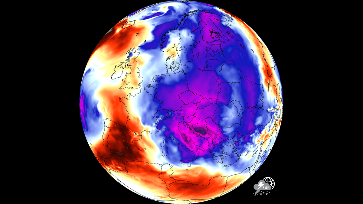
EUROPE — After enduring a relentless, historic stretch of extreme heat marked by relentless urban heat islands, soaring temperatures, and exhausting tropical nights, the eastern half of Europe is finally experiencing a dramatic atmospheric reversal. A powerful and dynamic weather pattern shift is sweeping across the continent, delivering much-needed cold refreshment to Central Europe, the Balkans, and parts of Eastern Europe.
While southwestern Europe remains locked under a punishing dome of intense heat, millions of residents and tourists across countries like Hungary, Poland, Romania, Italy, and Greece are finding vital relief. Daytime highs have dropped significantly below the 30°C threshold, and overnight temperatures are plunging into the comfortable mid-to-low 10s. This abrupt transition offers a welcome pause from heat stress, allowing overheated urban infrastructure and residential buildings to finally cool down during the peak of the summer season.
Main Facts: The Anatomy of Europe’s Weather Reversal
The sudden transition from extreme, persistent heat to unseasonable coolness is driven by a profound shift in continental pressure systems and upper-level atmospheric flow.
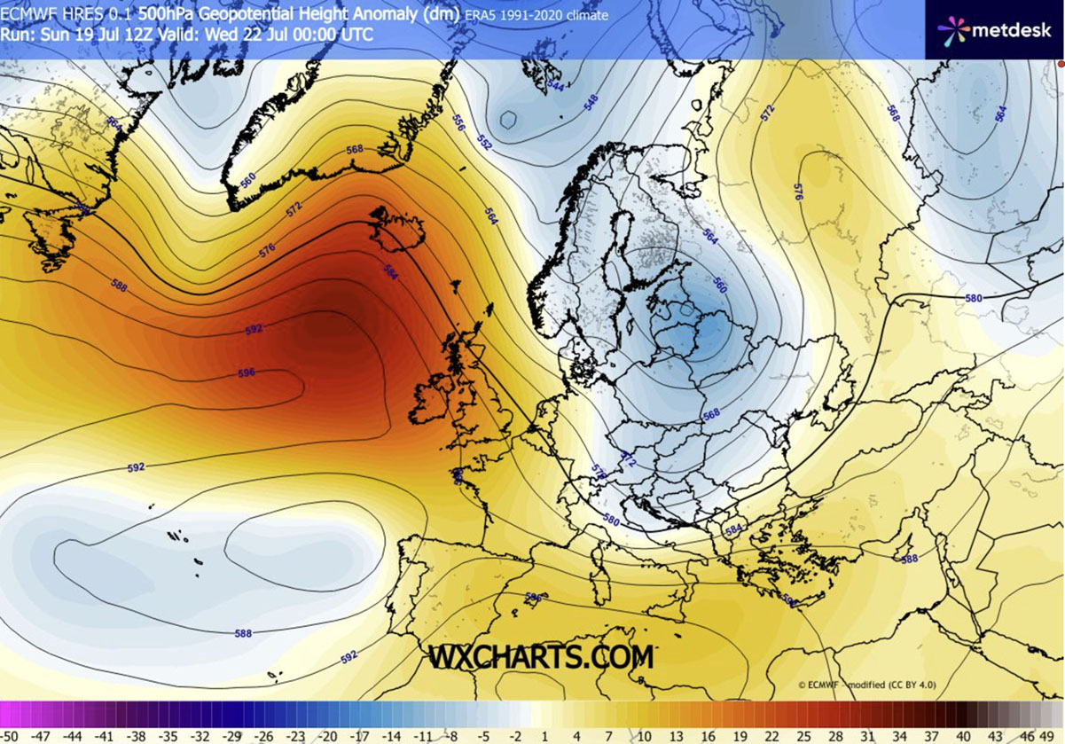
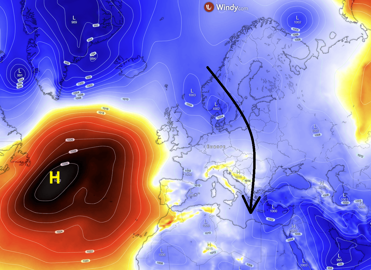
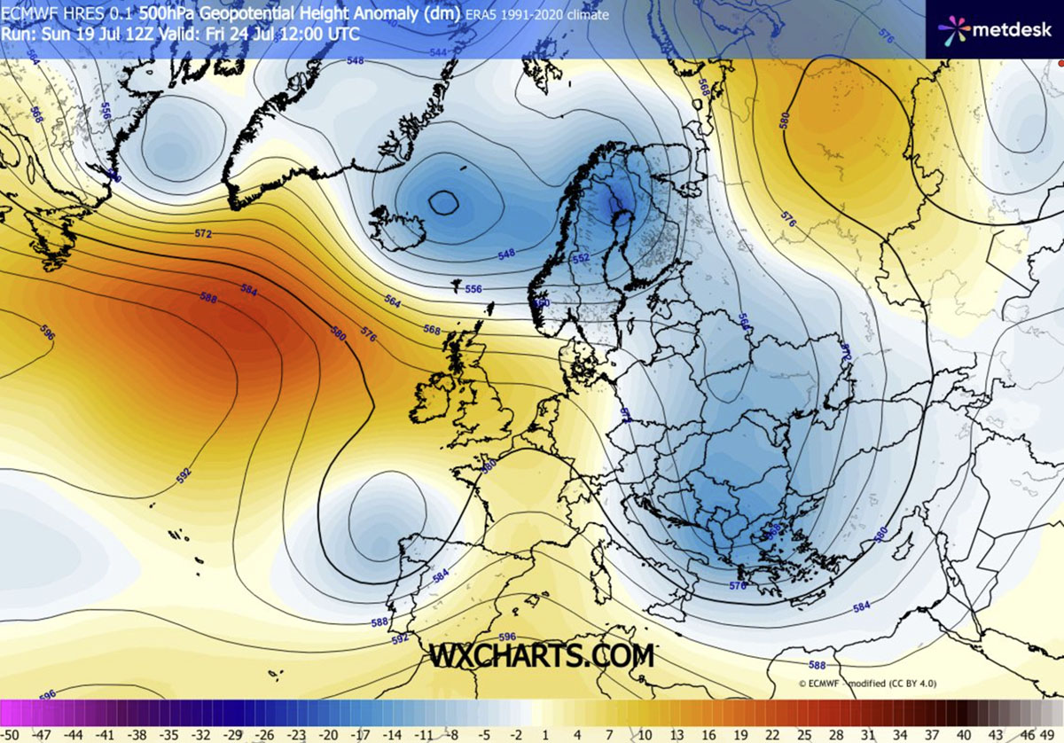
- The Driving Mechanism: A strong upper-level ridge has entrenched itself over the Atlantic Ocean, creating an atmospheric block. This configuration forces a deep low-pressure trough to develop over northern Europe, subsequently dragging an expansive, unseasonably cold air mass far to the south.
- Temperature Anomalies: By mid-to-late week, large swathes of Central and Eastern Europe are experiencing temperatures 4°C to 8°C below the seasonal average. In the southern Balkans, southern Italy, and Greece, surface and lower-atmosphere anomalies are plunging an impressive 10°C to 12°C below normal for late July.
- Geographical Divide: While Central Europe, the Balkans, and parts of Eastern Europe enjoy crisp, refreshing conditions, the Iberian Peninsula (Spain and Portugal) remains dangerously hot, with daytime temperatures continuing to soar into the 40s Celsius.
- Associated Hazards: The sweeping cold front is bringing more than just comfortable temperatures. Strong, gusty winds are exacerbating drought conditions, keeping wildfire risks exceptionally high. Furthermore, the collision between the incoming cold air mass and residual Mediterranean heat is sparking severe thunderstorms, torrential downpours, and localized flooding from Italy down to the southern Balkans.
Chronology of the Shift: How the Cold Wave Unfolds
Meteorological monitoring indicates that the atmospheric flip is progressing in distinct phases, steadily marching from northern and central latitudes toward the Mediterranean basin.
Early Week: The Initial Incursion
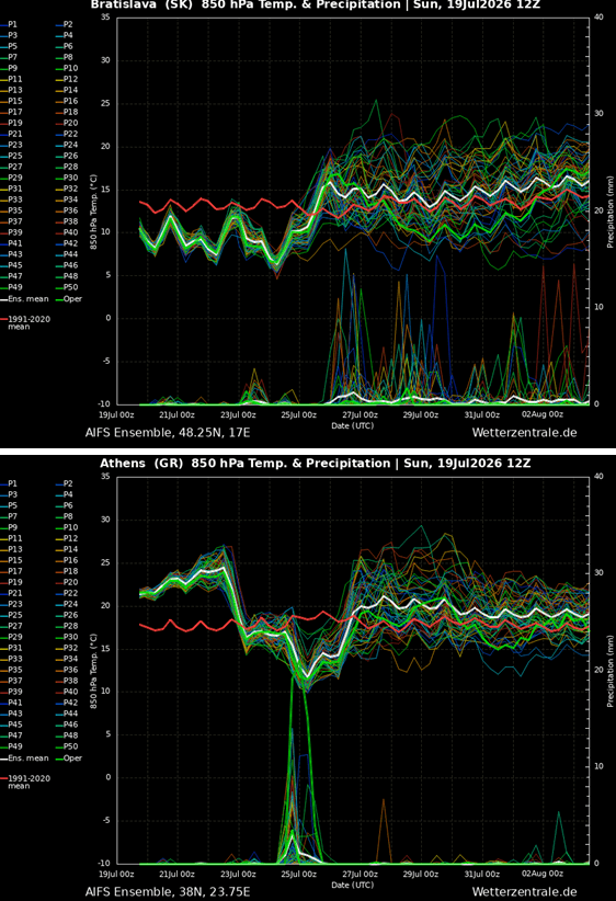
The atmospheric transformation began as the Atlantic blocking pattern strengthened, allowing northern European cold air to spill across the continent’s northern tier. By mid-week, countries spanning from the Benelux union, Germany, and Poland down to the northern Balkans recorded a stark reduction in heat. Daytime highs tumbled into the low-to-mid 20s. Crucially, nighttime temperatures offered immediate respite, dropping into the teens and allowing homes and urban apartments trapped in multi-week heat domes to shed accumulated heat.
Mid-Week: Intensification and Wind Dynamics
As the surface pressure gradient tightened between high pressure in the west and falling geopotential heights in the east, a meridional flow established itself. This channel directed arctic and sub-polar air masses deep southward. Regions including northern Italy, Slovenia, Croatia, Austria, Czechia, Slovakia, and Poland bore the brunt of the primary temperature anomaly by Wednesday and Thursday. Accompanying this air mass were brisk, gusty winds that maintained a refreshing chill across the broad plains and valleys, though they compounded moisture deficits in parched soils.
Late Week and Weekend: Deep Southward Penetration
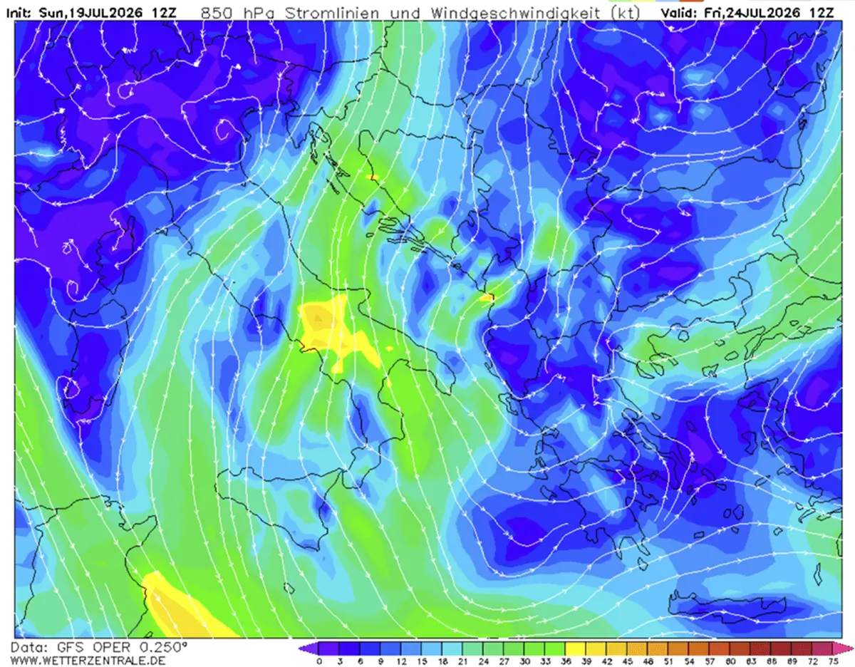
By Friday and Saturday, the core of the eastern trough is slated to dig deeply into the southern Balkans and the Eastern Mediterranean. This positioning will deliver some of the most striking weather anomalies of the summer season. While tourists in Greece and southern Italy welcome the sudden break from oppressive heat, meteorologists warn that the sharp thermal gradient will peak in atmospheric instability, unleashing powerful convective storms and locally heavy rainfall before the cool pattern entrenches itself for the weekend.
Supporting Data: Meteorological Metrics and Projections
Advanced forecasting models, atmospheric sounding data, and surface observations provide a comprehensive picture of the scale and intensity of this late-July weather anomaly:
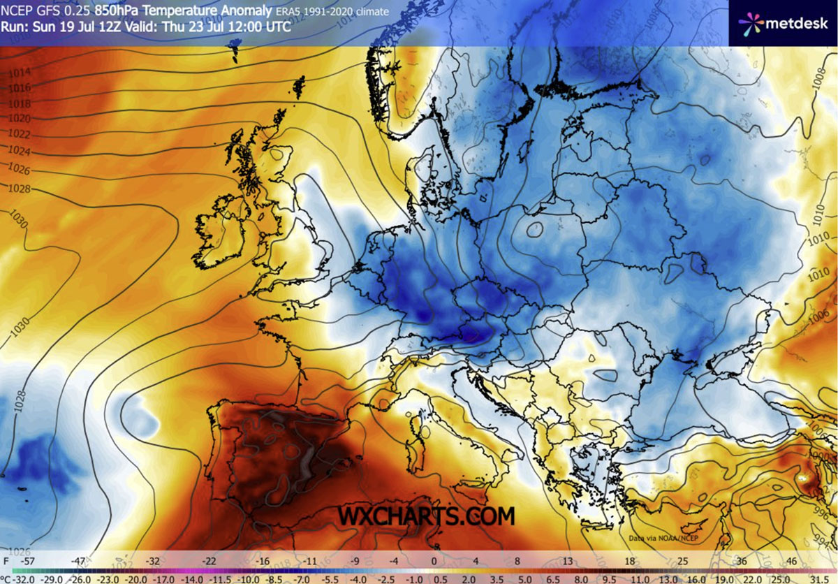
- 850 mbar Temperature Anomalies: Upper-air charts display temperature departures reaching 8°C to 12°C below climatological norms across the southern Balkans and Greece by Friday. This indicates a deeply entrenched cold pool extending well above the surface layer.
- Surface Minimum Temperatures (Tmin): Clear night skies combined with incoming cool air masses are driving morning lows down into the low-to-mid 10s (°C) across central and eastern regions. Valleys shielded from wind are experiencing even sharper nocturnal drops.
- Surface Maximum Temperatures (Tmax): Daytime peaks across Central Europe and northern parts of the Balkans are capped in the low-to-mid 20s. Even in traditionally scorching southern destinations such as Greece, Turkey, and southern Italy, maximum temperatures late in the week will be temporarily restrained to the upper 20s and low 30s.
- Precipitation and Instability (CAPE): Elevated Convective Available Potential Energy (CAPE) values are materializing along the collision zone between the advancing cold front and stagnant warm air. Significant precipitation accumulations are modeled across Greece, Romania, the Black Sea basin, and Ukraine, alongside a secondary active precipitation corridor over northeastern Europe driven by cold northerly winds interacting with the warmer Baltic Sea.
Official Responses and Public Sector Implications
Municipalities, emergency services, and public health authorities across Central and Eastern Europe have adjusted their operational postures in response to the rapid weather evolution.
Urban Heat Mitigation and Infrastructure
During the height of the preceding heatwave, municipal governments in cities like Budapest, Warsaw, and Bucharest grappled with severe urban heat island effects, strained electrical grids due to relentless air conditioning demand, and degraded asphalt infrastructure. The arrival of the cold wave has granted city administrators a vital window to conduct maintenance, ease cooling demands on power grids, and allow urban heat sinks to dissipate. Public parks and recreational spaces, previously deserted during peak afternoon hours, are seeing a resurgence of outdoor activity.
Emergency Services and Wildfire Management
Despite the psychological relief brought by the drop in temperature, civil protection agencies remain on high alert. Emergency management services in the Balkans and Italy emphasize that the cold wave is characterized by dry, windy conditions. The combination of low relative humidity, strong gusts, and parched vegetation means that accumulated wildfire risks have not dissipated. Firefighting aviation assets remain strategically positioned, and red-flag fire warnings stay in effect across multiple high-risk sectors.
Agricultural and Tourism Sectors
For the millions of international tourists visiting Central and Southern Europe during peak holiday season, the timing of the cool-down has been largely praised, transforming sightseeing from an endurance test into a comfortable experience. Conversely, agricultural sectors face a mixed outlook. While the sudden thunderstorms bring localized drought mitigation, torrential downpours carry the risk of flash flooding and crop damage in areas where soils have been baked hard by weeks of relentless sun.
Broader Implications: A Volatile Summer Pattern
This dramatic shift from persistent, stifling heatwaves to unseasonable cold waves underscores the increasing volatility of European weather patterns. Atmospheric blocking events—such as the persistent high-pressure ridge over the Atlantic that enabled this cold descent—are central subjects of ongoing climatological research regarding shifting jet stream behaviors.
As the northern cold wave solidifies its grip over Eastern and Central Europe, meteorological agencies continue to monitor the persistent thermal dome over the Iberian Peninsula, where extreme heat warnings remain firmly in place. For the millions residing under this week’s refreshing northern draft, however, the current pattern offers a historic, albeit temporary, reprieve from the relentless pressure of Europe’s changing summer climate.
