

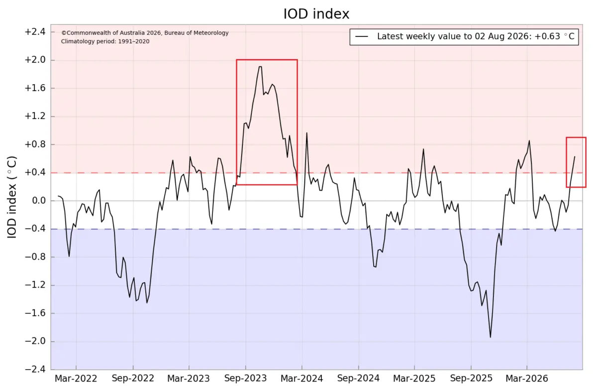
As the Northern Hemisphere transitions through the autumn months, climatologists and long-range forecasters are closely monitoring an extraordinary convergence of oceanic and atmospheric anomalies. A rapidly strengthening Super El Niño in the tropical Pacific is now interacting with a developing positive Indian Ocean Dipole (IOD).

This rare dual-ocean forcing mechanism is serving as a planetary weather engine, generating synchronized tropical wave patterns that will directly influence jet stream configurations, temperature distributions, and snowfall trends across North America and Europe throughout the Winter 2026/2027 season.
Main Facts: The Anatomy of a Dual-Ocean Forcing Event
The meteorological narrative for the upcoming winter centers on two primary phenomena operating in tandem:
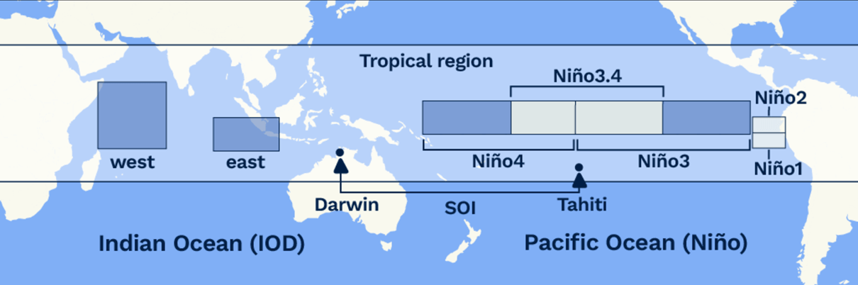
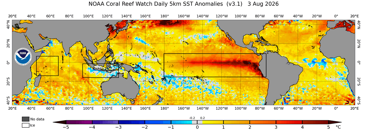
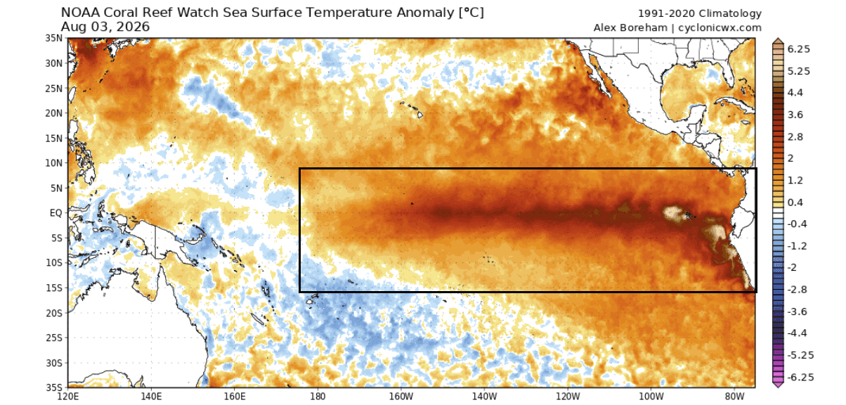
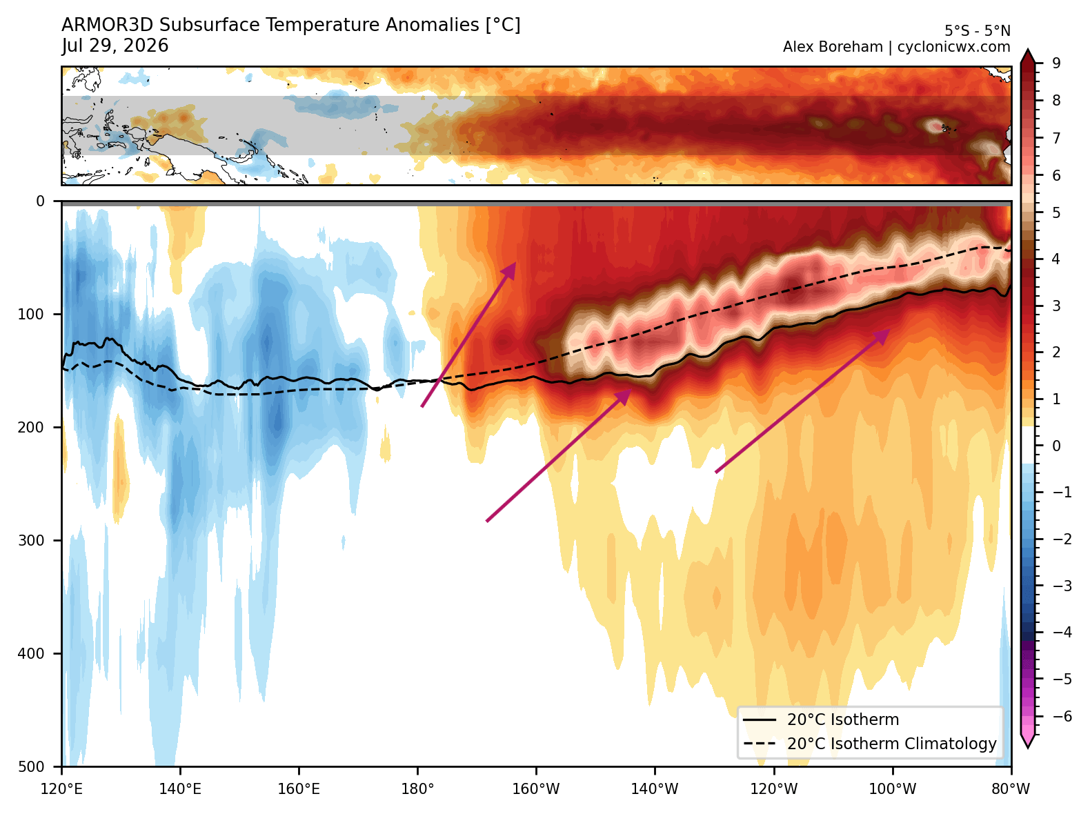
- The Super El Niño: Sea surface temperature anomalies in the central and eastern equatorial Pacific (ENSO regions) have accelerated dramatically into August, with subsurface and surface readings peaking at magnitudes exceeding historical norms by 3°C to 5°C. Subsurface Kelvin waves are actively driving warm water toward the eastern Pacific, ensuring a sustained, high-intensity event.
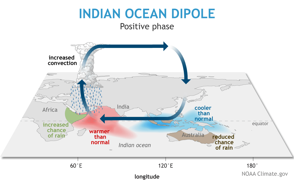
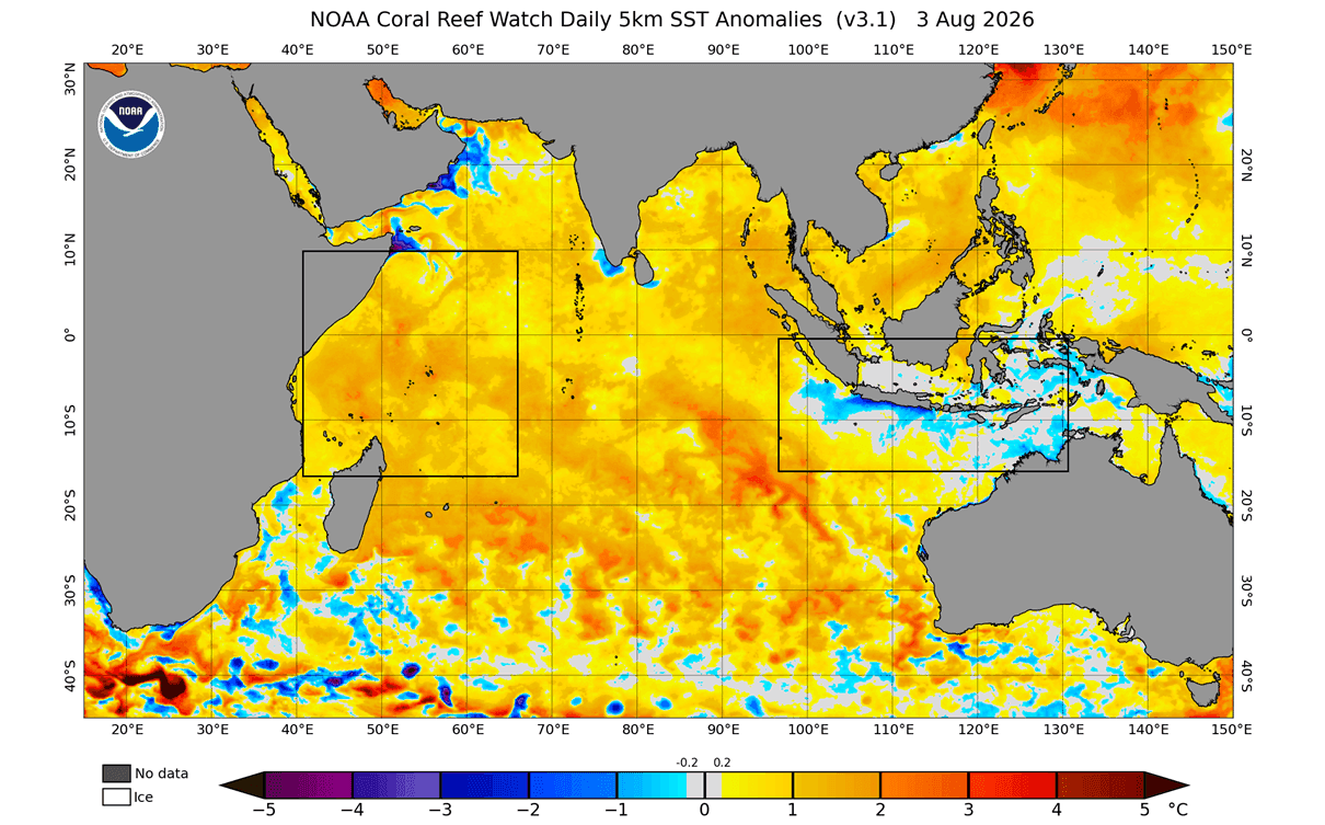
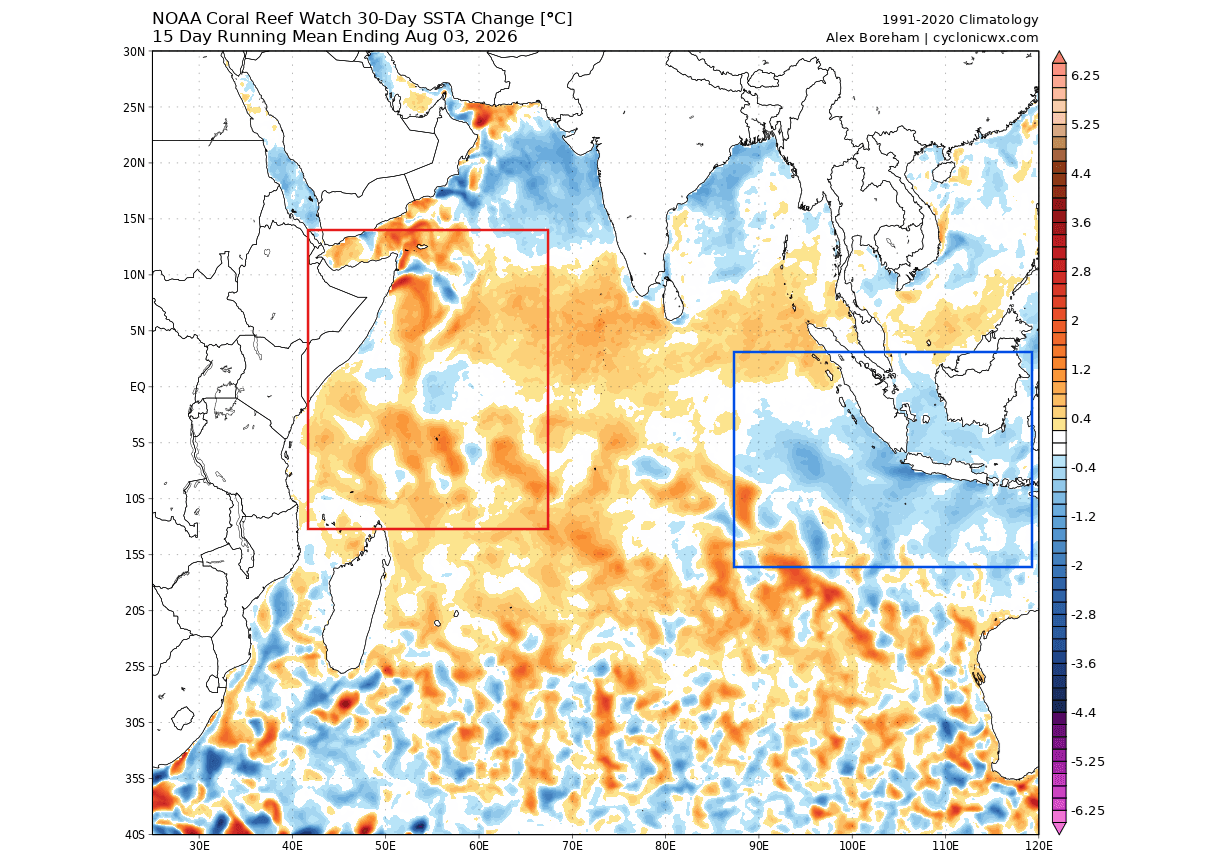
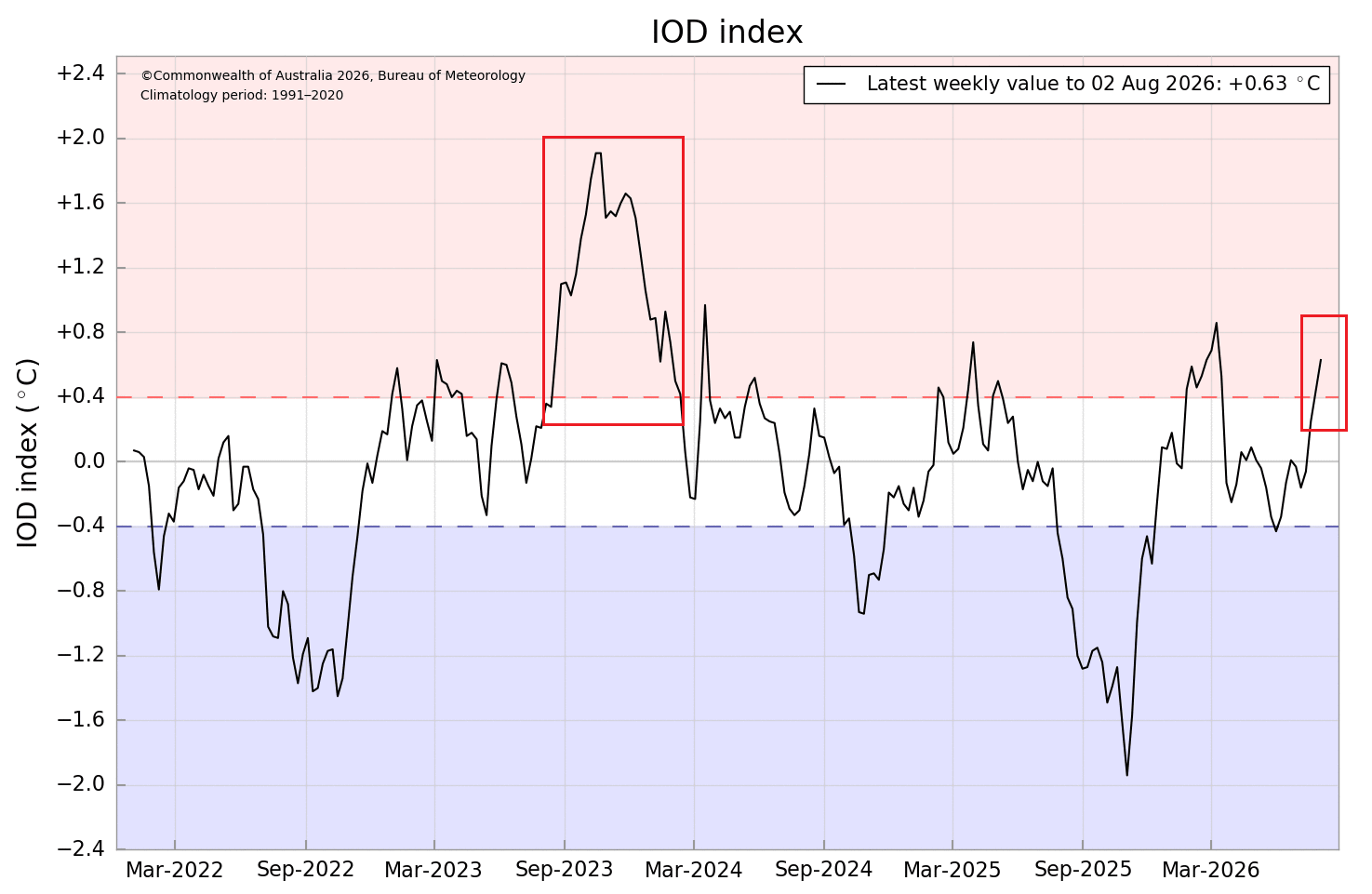
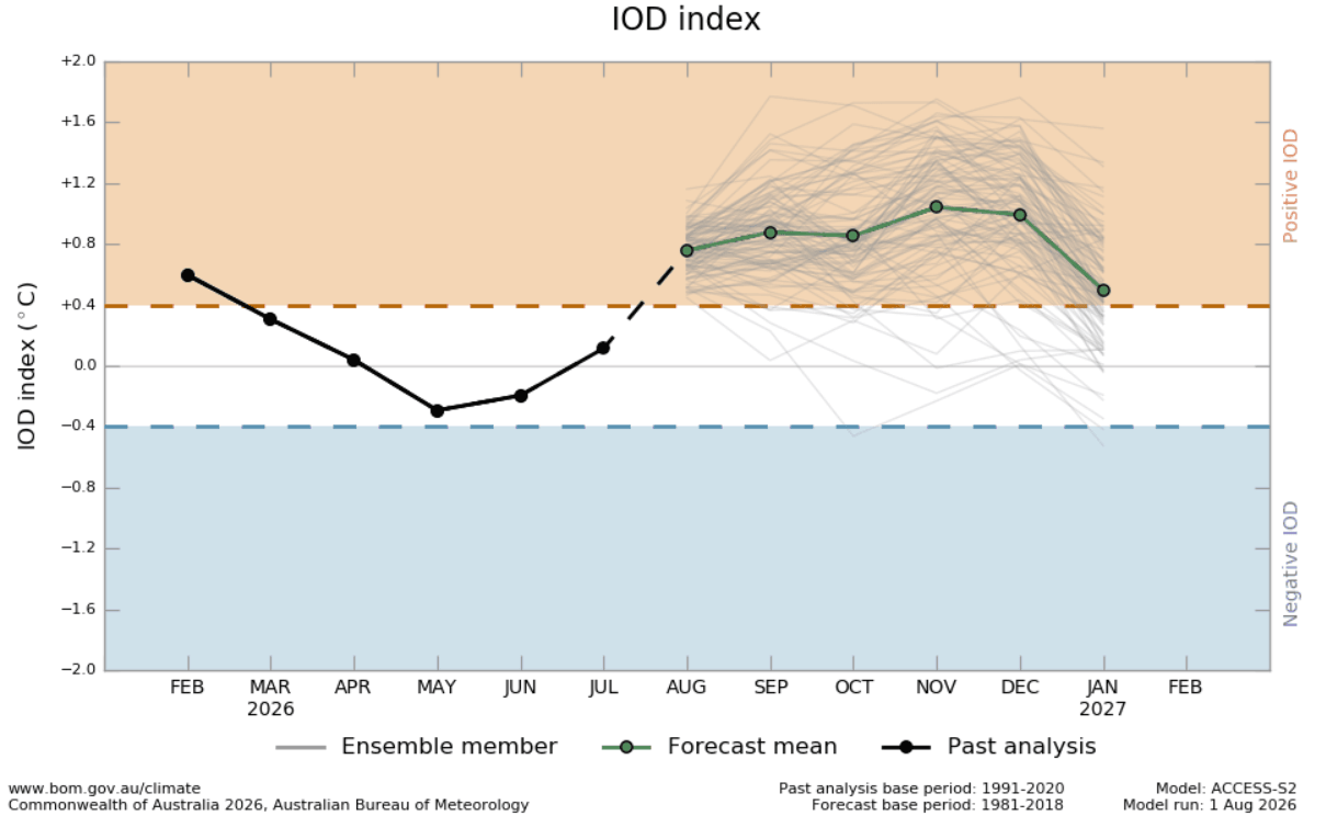
- The Positive Indian Ocean Dipole (IOD): Concurrently, a positive IOD phase has emerged in the Indian Ocean. Characterized by cooler-than-average sea surface temperatures in the east and warmer waters in the west, this dipole establishes a massive atmospheric cell marked by rising air over the western basin and sinking air over the eastern basin.
- Global Teleconnections: When paired, the Super El Niño and the positive IOD create a unified atmospheric engine. This synchronization alters tropical convection and pressure fields, launching planetary-scale Rossby wave trains that dictate storm tracks and temperature baselines across the Northern Hemisphere.
Chronology: From Late Summer Signals to Winter Manifestation
Understanding the trajectory of the Winter 2026/2027 pattern requires tracking the evolution of these anomalies from their nascent stages in mid-summer through their projected winter peaks.
August: The Acceleration Phase
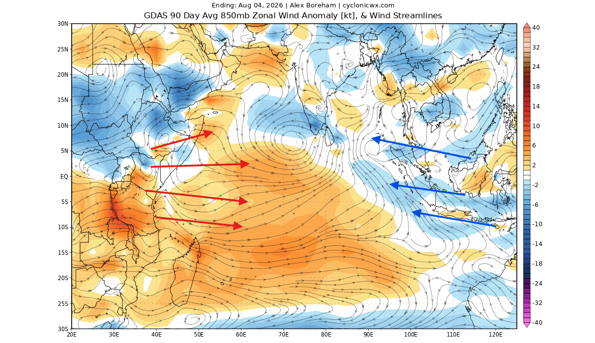
By early August, oceanic analyses revealed that subsurface warming in the Pacific had matured into a robust Kelvin wave, pushing surface anomalies past the traditional threshold for a "Super" El Niño classification (+2°C). Simultaneously, trade wind anomalies across the Indian Ocean began to weaken in the west while strengthening in the east, effectively triggering the onset of a positive IOD phase. Ensemble forecasts from major modeling centers, including the ECMWF and NOAA’s NCEP, indicated that these signals would not be transient, but would instead lock into a sustained, mutually reinforcing state through the autumn.
Fall 2026: Establishing the Atmospheric Bridge
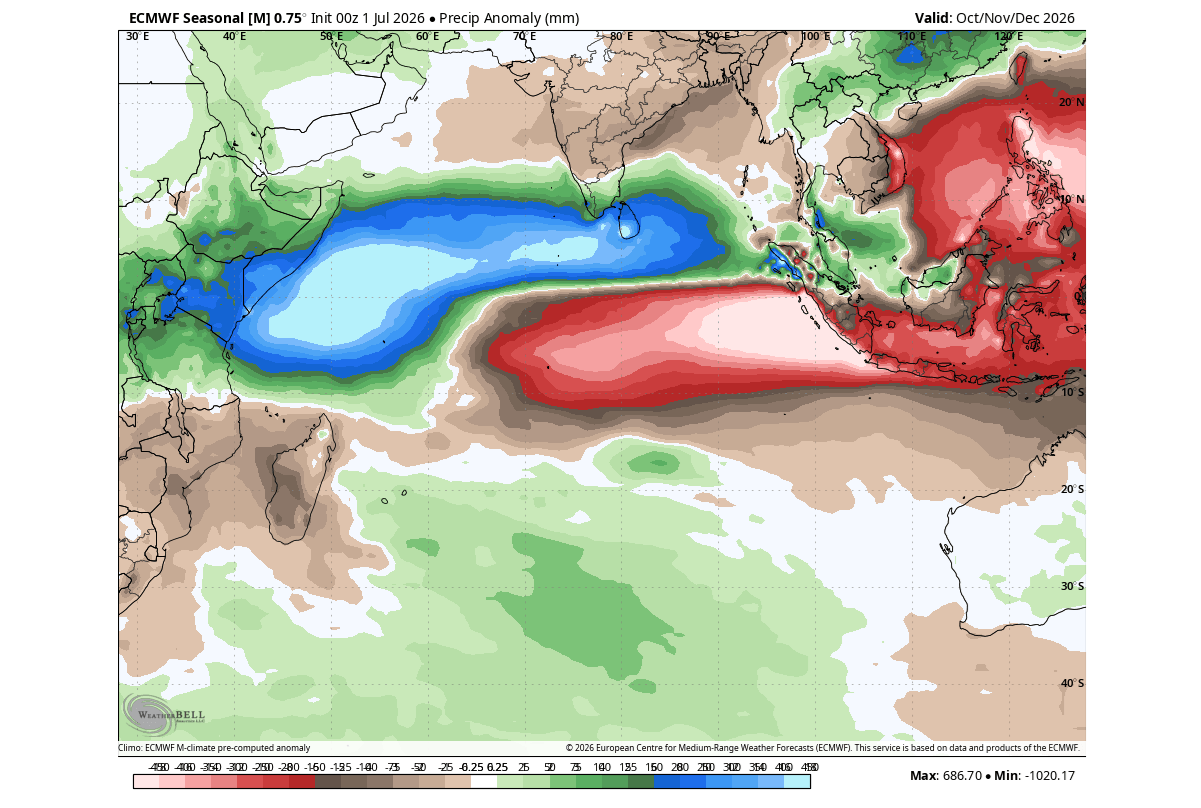
As the calendar turns deeper into autumn, the tropical forcing translates into regional pressure changes. Altered precipitation patterns become evident, characterized by severe rainfall deficits over the eastern Indian Ocean and excessive moisture in the west. This thermal contrast anchors a permanent standing wave in the global atmosphere. As historical correlations and modern ensemble forecasts suggest, this bridge allows tropical energy to propagate northward and eastward, setting the stage for the winter jet stream configuration.
Early Winter (December 2026): The Initial Split-Flow
By December, the ECMWF pressure anomaly forecasts show a high-amplitude wave pattern taking shape across North America. A dominant blocking high-pressure ridge establishes itself over Canada, while a deep, energetic low-pressure trough digs out from the North Pacific into the southern and eastern United States. This configuration initiates a classic continental split-flow regime, separating mild northern air masses from active southern storm tracks.
Mid-to-Late Winter (January–February 2027): Intensification and Peak Impacts
As the winter season progresses into its core months, the atmospheric wave train intensifies. The North American blocking pattern acts as a resilient barrier, forcing Pacific storm tracks persistently through the central, southern, and eastern United States. For Europe, the persistence of these downstream teleconnections favors a strengthened North Atlantic westerly flow, maintaining mild yet unsettled conditions across much of the continent.
Supporting Data: Observational Metrics and Modeling Consensus
The confidence behind the Winter 2026/2027 outlook stems from a convergence of historical climate data and high-resolution numerical model outputs.
Oceanographic Observations
- Pacific ENSO Indices: Multi-model ensembles—notably the European Centre for Medium-Range Weather Forecasts (ECMWF) and the National Centers for Environmental Prediction (NCEP) Climate Forecast System (CFSv2)—project peak surface anomalies surpassing the extreme +3°C to +4°C thresholds. Subsurface temperature anomalies within the upper 500 meters of the equatorial Pacific have recorded cores exceeding 8°C above normal, driven by persistent westerly wind bursts.
- Indian Ocean Metrics: Dipole Mode Index (DMI) observations confirm a transition into the positive phase, supported by a 30-day change analysis showing progressive cooling in the eastern tropical Indian Ocean and corresponding warming off the coast of Africa.
Atmospheric Diagnostics
Velocity potential anomaly analyses from the ECMWF highlight the structural integrity of this dual-ocean engine. Persistent rising motion (divergence aloft) dominates the tropical Pacific and western Indian Ocean, balanced by robust sinking motion (convergence aloft) over Indonesia and the eastern Indian Ocean. This Walker circulation anomaly underpins the planetary-scale wave train, dictating the behavior of the mid-latitude jet streams.
Official Responses and Meteorological Implications
As seasonal outlooks solidify, regional weather agencies and long-range forecasting centers are adjusting their winter expectations to account for the unique compounding effects of the Super El Niño and positive IOD.
North American Implications
- Temperature Trends: A distinct north-south divide is anticipated across the continent. Canada, the Pacific Northwest, and the northern tier of the United States are favored to experience above-normal temperatures, insulated by northern blocking ridges. Conversely, the southern United States, Texas, the Gulf Coast, and the Southeast face a cooler-than-normal or near-normal regime governed by persistent cloud cover and storminess.
- Precipitation and Snowfall: The active southern storm track will enhance moisture transport across California, the Southwest, and the Gulf Coast, extending up the Eastern Seaboard. Where this abundant moisture encounters periodic drops of Canadian continental air, the potential for significant winter storms, ice events, and elevated snowfall totals increases markedly across the Central Plains, Midwest, Mid-Atlantic, and interior Northeast. Conversely, the Pacific Northwest and northern Great Lakes are expected to see below-average seasonal snowfall.
European Implications
While Europe is traditionally more distant from direct tropical forcing, downstream Rossby wave propagation plays a critical role.
- Westerly Flow: The projected pressure pattern features a high-pressure influence from the south paired with low-pressure anomalies over northern and northwestern Europe. This north-south pressure gradient invigorates the Atlantic westerly flow.
- Temperature and Precipitation: Most of the continent is projected to experience above-normal seasonal temperatures due to maritime air advection. However, enhanced moisture transport will result in above-average precipitation totals across Western and Northern Europe. Broad-scale snowfall potential remains largely restricted to high elevations and far-northern latitudes, though transient low-pressure systems may occasionally deliver colder northerly drops to the United Kingdom and Ireland.
Conclusion
The convergence of a historic Super El Niño and a well-defined positive Indian Ocean Dipole sets the stage for a highly dynamic and structured winter season in 2026/2027. By coupling ocean anomalies with upper-level atmospheric wave trains, this dual-ocean forcing provides forecasters with high-visibility signals regarding jet stream positioning, storm tracks, and regional climate anomalies. As data continues to update through the autumn transition, continuous monitoring will refine our understanding of how these powerful teleconnections will ultimately manifest at the local level.
