

MADRID/LISBON — An unforgiving atmospheric furnace is setting its sights squarely on the Iberian Peninsula this week, as an excessive, potentially record-shattering heatwave threatens to drive temperatures into a staggering 45 °C to 47 °C range.
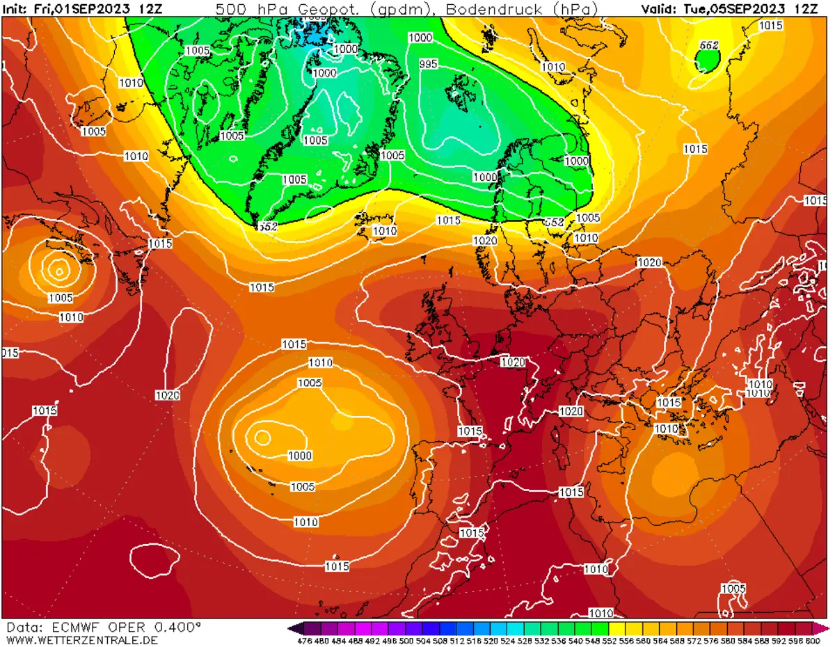
Driven by a stubborn, highly stable "heat dome" of high pressure anchoring itself over southwestern Europe, Spain and Portugal are bracing for what meteorologists warn could be one of the most intense, dangerous, and physically punishing early-summer thermal anomalies in modern recording history.

Communities stretching from the sun-drenched plains of Andalusia up through the interior plateaus are scrambling to prepare for extreme conditions that will test the absolute limits of human endurance, agricultural resilience, and local energy infrastructure. Compounding the physiological crisis, nighttime relief will be virtually nonexistent; overnight lows are forecasted to linger in the mid- to upper 20s Celsius, denying millions of residents the vital cool-down periods required for the human body to recover.
Main Facts: The Anatomy of a Mega-Heatwave
The upcoming thermal surge is not merely a standard, seasonal mid-summer warm-up. It represents an aggressive, large-scale injection of superheated air pulled directly from the heart of the Sahara Desert, supercharged by an Omega-blocking pattern taking root over southwestern Europe.
The Synoptic Driver: The Heat Dome and Omega Blocking
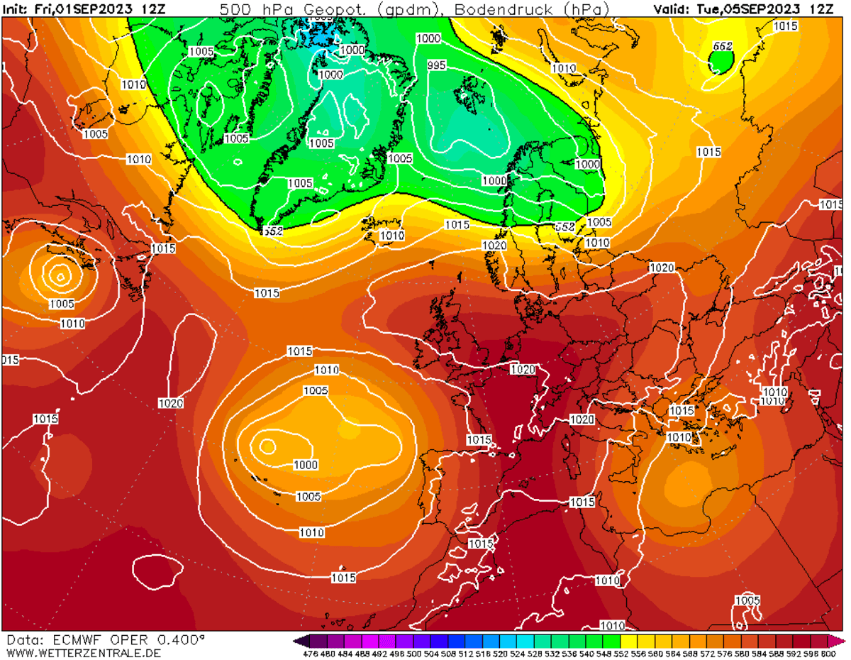
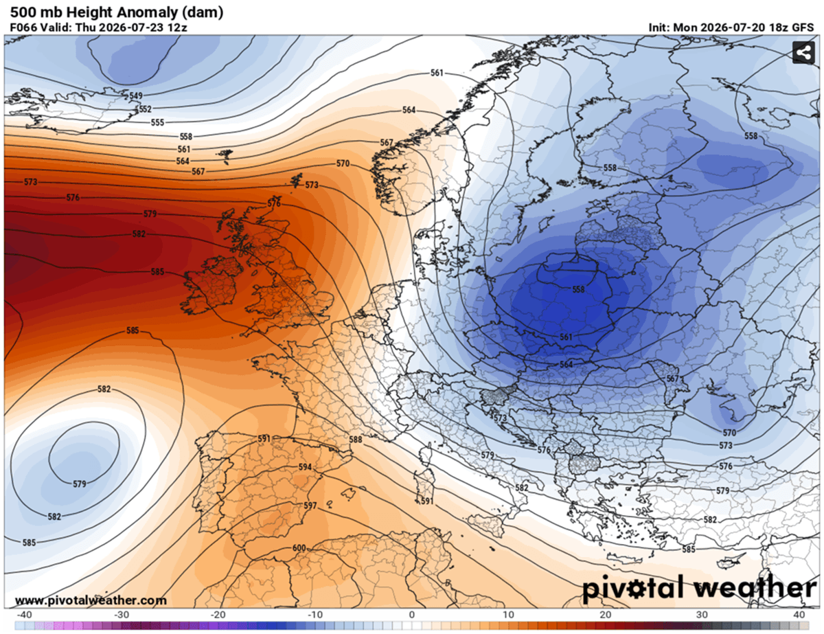
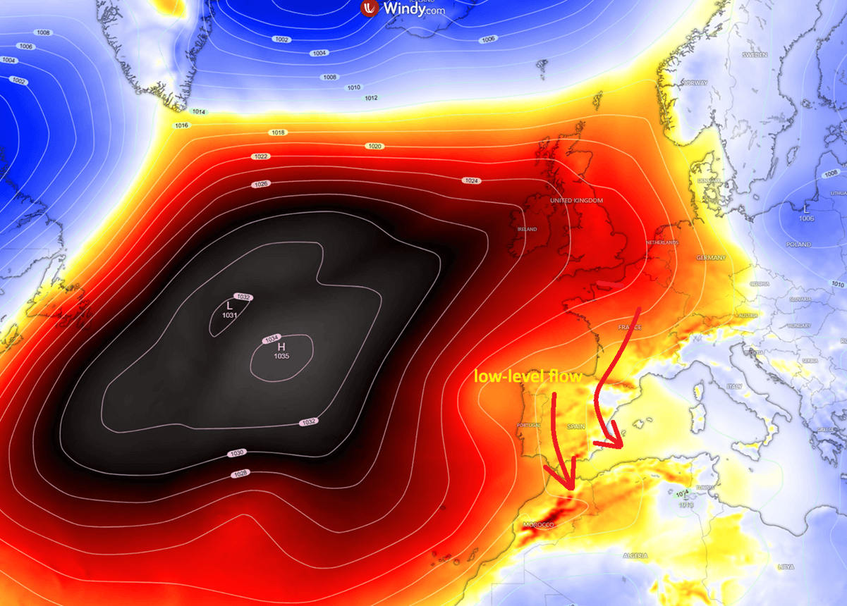
At the core of this extreme weather event is a robust atmospheric blocking pattern featuring an expansive upper-level ridge—a classic "heat dome." Reinforced by a cut-off low-pressure system lingering to its west, this synoptic setup creates an atmospheric lid over the region.
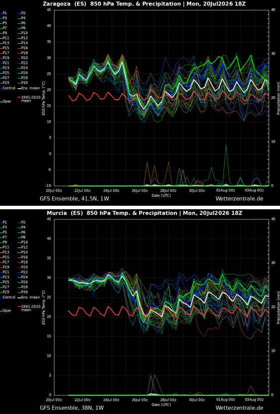
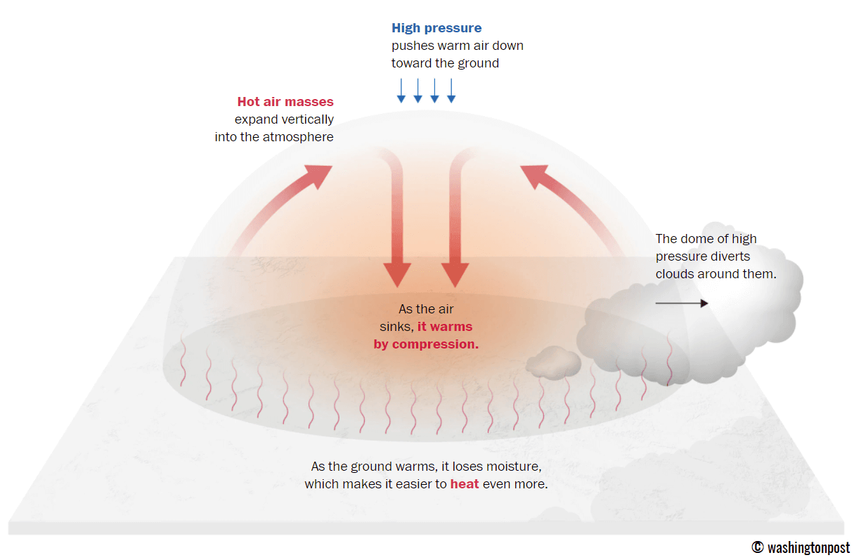
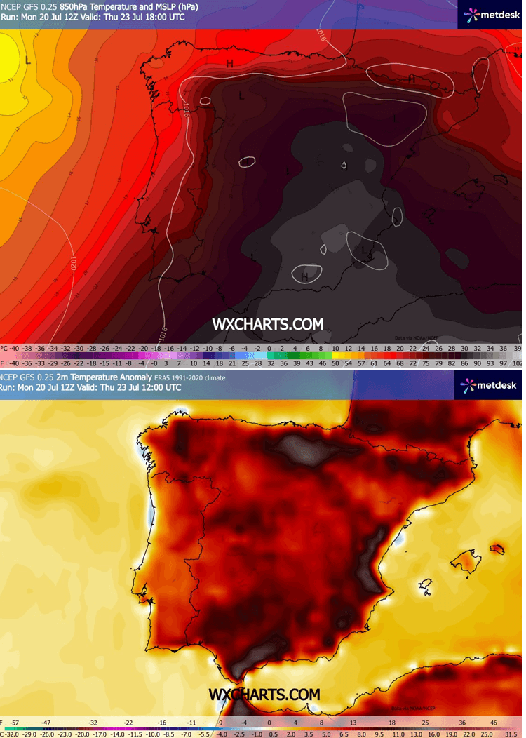
The heat dome functions identically to a pressure cooker lid. High-altitude high pressure forces warm air downward, compressing it as it sinks toward the surface. This adiabatic compression strips the air of remaining moisture and rapidly elevates surface temperatures. At the 850 mbar level (roughly 1,500 meters above sea level), temperatures are projected to breach an extraordinary 30 °C to 31 °C—values running 10 °C to 15 °C above the seasonal norm for late July.
Terrain Dynamics and Foehn Effects
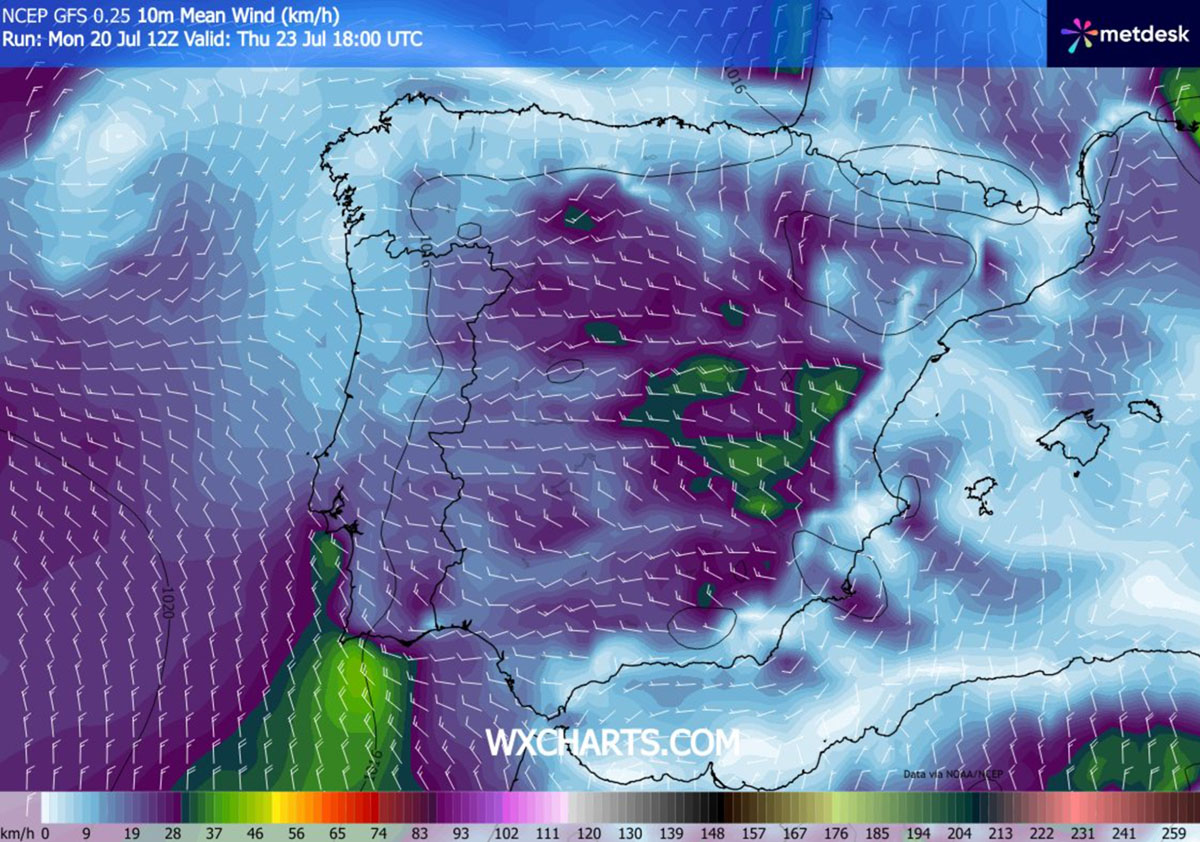
Local geography will play a critical role in driving near-surface temperatures toward the 47 °C threshold. As regional winds sweep across the peninsula, localized downslope (foehn) effects over the central plateaus and mountain ranges will force dry air masses to cascade rapidly down toward the eastern and southern lowlands.
This mechanical warming explains why the southern and eastern Spanish plains—particularly the Guadalquivir and Ebro valleys, alongside regions like Murcia, Alicante, Valencia, and Castilla-La Mancha—frequently record the most extreme, near-record spikes during continental heatwaves.
Supporting Data: Contextualizing Historic Records
To understand the severity of the incoming atmospheric crisis, meteorologists are looking back at previous historic heat events that pushed the limits of European climate records.
Iberian and European Benchmarks
- The Spanish Record: The official national record stands at 47.6 °C, registered at La Rambla in the Córdoba countryside (Guadalquivir basin) during a previous historic surge. On that same day, nearby Montoro reached 47.4 °C, while Córdoba Airport peaked at 46.9 °C.
- The European Record: The continent-wide record remains 48.8 °C, observed in Syracuse, Sicily, on August 11, 2021, and verified by the World Meteorological Organization (WMO). This eclipsed the long-standing 1977 record of 48.0 °C set in Athens and Elefsina, Greece.
With Spain’s national peak sitting just 1.2 °C below the absolute European record, weather model guidance highlights Murcia and the Ebro Valley as primary zones capable of challenging regional or national benchmarks this week.
Recent Regional Benchmarks (AEMET Observations)
- Alcantarilla Air Base, Murcia: Set a modern official benchmark of 47.0 °C on August 15, 2021, with Murcia city hitting 46.2 °C.
- Castlla-La Mancha: Talavera de la Reina reached 45.5 °C on August 14, 2021, closely followed by Almadén (45.4 °C), Puertollano (45.0 °C), and Puebla de Don Rodrigo (44.8 °C).
- Ebro Valley: Zaragoza Airport previously topped out at 44.5 °C on July 7, 2015.
Chronology of the Event: Day-by-Day Forecast
The evolution of the Omega block and its associated heat dome reveals a rapid intensification cycle culminating by mid-week, followed by a fractured relief pattern toward the weekend.
Early Week: The Mediterranean Precursor
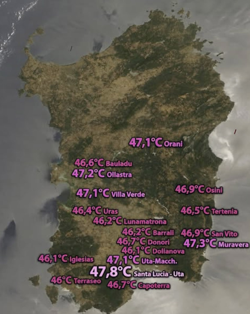
Before invading Iberia, the intense warm plume made its presence violently felt across North Africa and the central Mediterranean. Algeria and Tunisia recorded scorching daytime highs of up to 49 °C early in the week. Over the weekend, Sardinia, Italy, found itself directly beneath the nose of the warm plume, shattering local expectations:
- Santa Lucia-Uta: 47.8 °C
- Muravera: 47.3 °C
- Ollastra: 47.2 °C
- Orani, Villa Verde, and Uta-Macchiareddu: 47.1 °C
As the week progressed, the blocking high retrograded westward directly into the Iberian Peninsula, setting the stage for the current crisis.
Wednesday: The Onset
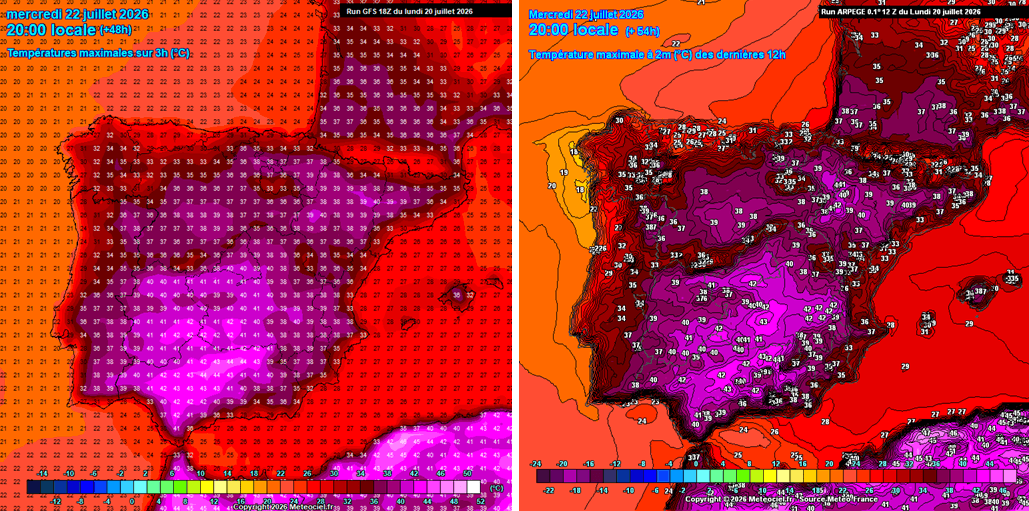
Global forecasting models (such as the GFS) and regional models (such as ARPEGE) show the heatwave rapidly intensifying. Central Spain is projected to record widespread highs of 42 °C to 44 °C, while the rest of Spain and neighboring Portugal experience peak afternoon temperatures ranging from 34 °C to 40 °C.
Thursday: The Peak Intensity
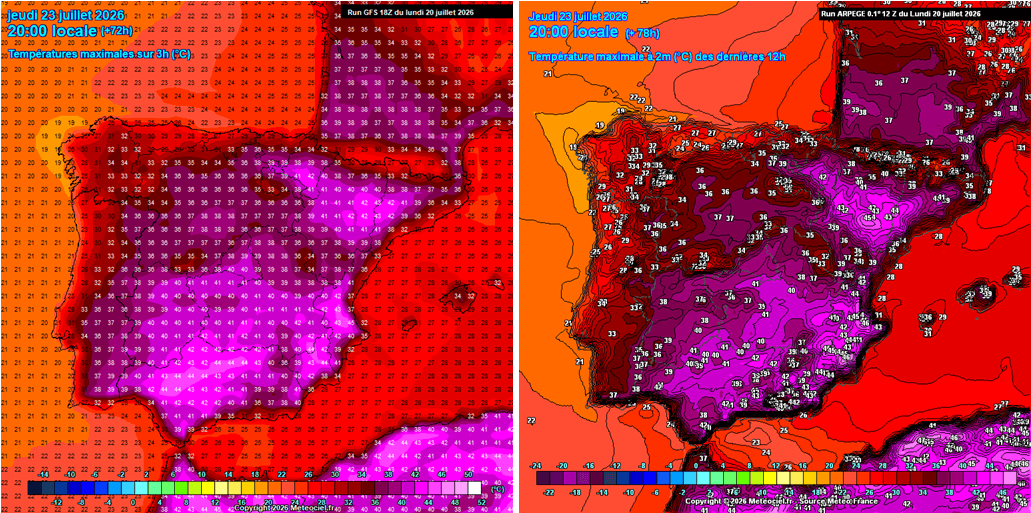
The air mass over the Iberian Peninsula is forecast to compress and warm further. Central Spain will climb into the low 40s, while eastern and southern lowlands surge to 44 °C to 46 °C.
Local valleys—particularly across the provinces of Murcia, Alicante, and Valencia—could see mercury readings exceed 46 °C, nearing 47 °C under the influence of dry, downsloping westerly winds. The Ebro Valley will similarly peak between 43 °C and 44 °C, while southern France prepares for upper-30s temperatures.
Friday: The Final Punch and Western Relief
Friday marks the final day of this acute heatwave phase for eastern and southern Spain, where lowlands will once again struggle against 45 °C peaks.
However, relief is on the horizon for western regions. A more humid air mass pushed in from the Atlantic will help drop temperatures below 40 °C across western Spain by Friday afternoon. Portugal will experience a noticeable cool-down, with maximums retreating into the upper 20s and low 30s.
Official Responses and Societal Implications
The consequences of this prolonged thermal peak extend far beyond physical discomfort, threatening core socioeconomic and environmental sectors across the peninsula.
Public Health and Vulnerability
Health authorities in Spain and Portugal have issued widespread red-level heat alerts. Public health campaigns emphasize the severe physiological risks posed by consecutive days of extreme heat and warm tropical nights.
- Vulnerable Populations: The elderly, young children, and individuals with pre-existing cardiovascular or respiratory conditions face heightened risks of heat exhaustion and fatal heatstroke.
- Outdoor Laborers: Construction workers, agricultural laborers, and open-air employees face extreme occupational hazards, prompting calls for mandatory midday work stoppages and adjusted shift hours.
- Urban Heat Islands: Impoverished urban areas featuring high concentrations of heat-trapping concrete, asphalt, and asbestos building materials face disproportionate mortality risks due to the lack of adequate cooling infrastructure.
The Threat of Explosive Wildfires
Perhaps the most immediate environmental danger accompanying the dome is the compounding wildfire threat. Meteorological agencies warn that the combination of record-breaking heat, prolonged drought conditions, and moderately strong, exceptionally dry winds will create a tinderbox environment.
Low relative humidity values, frequently dropping below 15% during peak afternoon hours, mean that any spark—whether from human activity or dry lightning—has the potential to ignite explosive, fast-moving wildfires that are nearly impossible to contain via conventional firefighting methods. Emergency response teams across Iberia remain on the highest state of operational alert.
Looking Ahead: The Broader European Outlook
As the Iberian Peninsula battles this intense mid-summer anomaly, atmospheric scientists are monitoring the potential retrogradation and eastward expansion of the heat dome. While a dramatic, refreshing cold wave sweeps across Eastern Europe and the Balkans—breaking prolonged heat in those regions—Western and Central Europe must remain vigilant.
Forecasting centers indicate that the atmospheric blocking pattern currently dominating the Mediterranean and Iberia may attempt to rebuild or expand northward toward the end of July. Meteorologists will continue to analyze global ensemble runs over the coming weekend to determine whether the thermal furnace will make a secondary push into wider European territories. Stay tuned for ongoing updates.
