

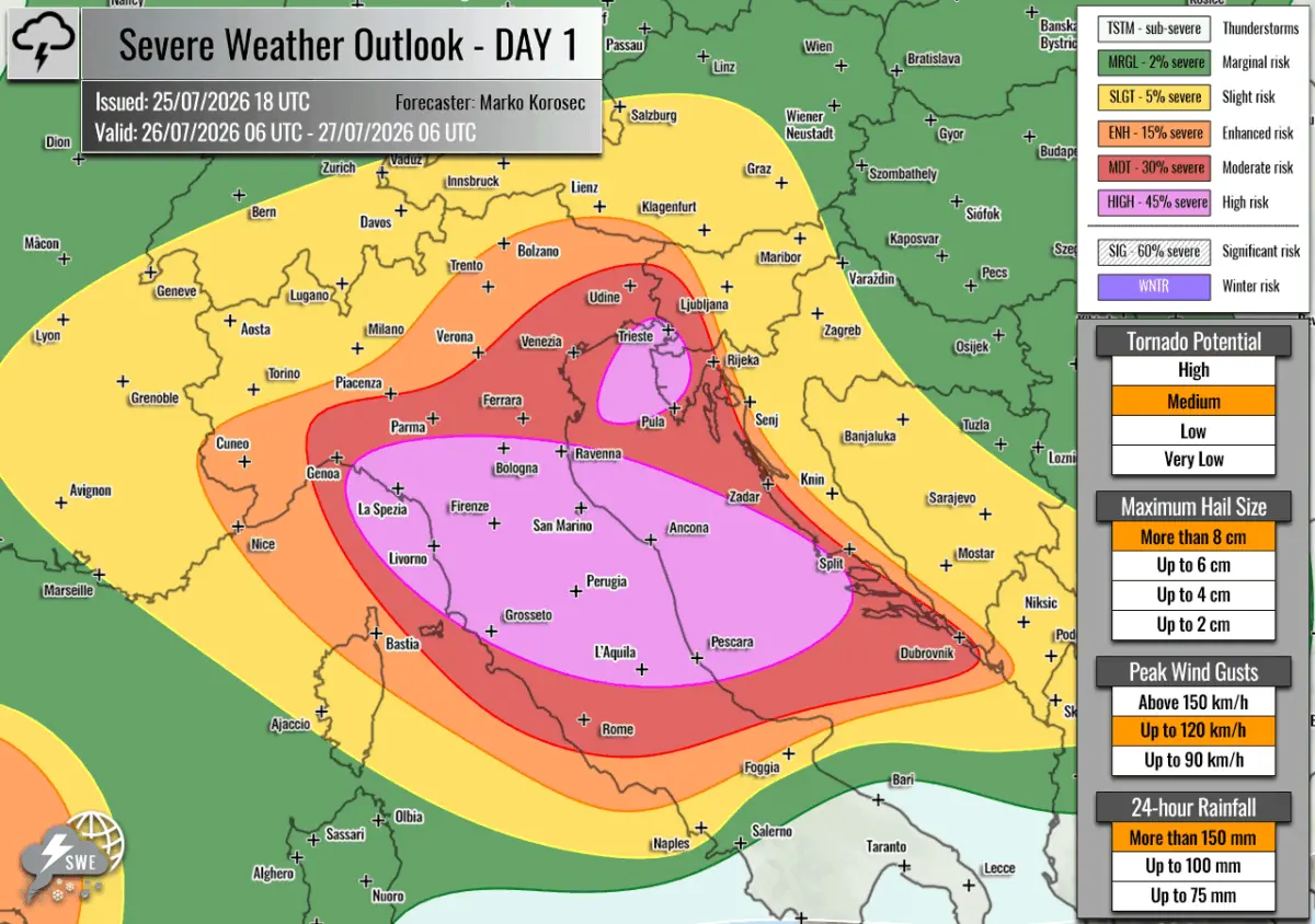
EUROPE — Meteorological authorities and severe weather forecasters have issued urgent warnings for a significant and potentially life-threatening severe weather outbreak slated to strike the north-central Mediterranean and the Adriatic Sea region. The severe convective event, valid from 06:00 UTC on Sunday, July 26, to 06:00 UTC on Monday, July 27, 2026, is expected to bring a volatile mix of severe hazards, including giant hail, destructive straight-line winds, tornadoes, and catastrophic flash flooding.
The forecast, compiled and issued by Severe Weather Europe and led by forecaster Marko Korošec, highlights an exceptionally dangerous setup driven by an intense clash between lingering regional heatwaves and an aggressive upper-level weather system.
Main Facts
The impending meteorological event is characterized by a dangerous convergence of extreme atmospheric instability and robust wind shear. A large upper-level trough has established itself across northern Europe, wedged firmly between potent blocking high-pressure systems over the Atlantic Ocean and Russia. This dynamic is driving a secondary, potent shortwave disturbance eastward across central Europe and into the Mediterranean basin.
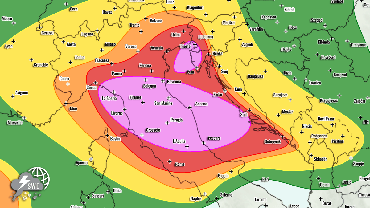
At the surface, a sprawling low-pressure system centered over western Norway is dragging a sharp cold front across the Alps, the northern Mediterranean, and deep into the Adriatic Sea and western Balkans. Ahead of this approaching frontal boundary, strong south-westerly mid-level winds are pumping rich, highly humid air from the central Mediterranean into the northern sector.
Coupled with the extreme ambient heatwave currently baking the Mediterranean, surface dew points have skyrocketed. This environment is expected to yield moderate to locally extreme instability, with Mixed-Layer Convective Available Potential Energy (MLCAPE) values surging between 2,000 and 3,000+ Joules per kilogram (J/kg) over the Tyrrhenian, Ligurian, and central Adriatic seas.
Key Hazard Breakdown:
- Torrential Rainfall & Flash Floods: High precipitable water (PWAT) values ranging from 45 to 60 mm create an environment ripe for excessive, training precipitation. Localized rainfall accumulations of 100 to 200 mm are projected within a 6-to-12-hour window.
- Damaging Winds & Giant Hail: Severe supercells and fast-moving multicell clusters will generate destructive straight-line winds and large to "giant" hail—with some stones potentially exceeding 10 centimeters (4 inches) in diameter.
- Tornado Threat: Enhanced low-level shear and strong storm-relative helicity create a favorable environment for tornadic supercells, posing a significant threat across central Italy and the northern Adriatic coastline.
Chronology of the Event: Expected Timeline
The severe weather setup is projected to unfold in rapid succession, moving from west to east across the European landscape throughout Sunday and into Monday morning.
Sunday, July 26 (Morning to Afternoon)
- 06:00 UTC – Midday: Convective activity is forecast to fire up rapidly during the early morning hours. Storms will initiate over the Ligurian Bay and quickly track eastward toward the rugged terrain of the northern Apennines.
- Midday – Afternoon: As the upper-level wave pushes over the Alps and into the northern Mediterranean, storms will intensify dramatically. The primary storm mode will shift toward intense, discrete supercells and training multicells, slamming into northern and central Italy.
- Afternoon – Evening: Severe weather spreads eastward into the Adriatic Sea, impacting the coastal regions of northwestern Croatia (particularly the Istria peninsula) and southwestern Slovenia. Surface convergence along the nose of a low-level jet will anchor slow-moving or training storm cells, drastically raising flash flood risks during the peak summer tourist season.
Sunday Night to Monday, July 27 (Early Morning)
- Evening – 06:00 UTC Monday: Storms will increasingly merge into large, organized convective clusters as they traverse the Adriatic and push into parts of the western Balkans. The threat will slowly transition from discrete supercells to a widespread damaging wind and excessive rainfall event before gradually weakening as it moves further east by Monday morning.
Supporting Meteorological Data and Regional Risk Zones
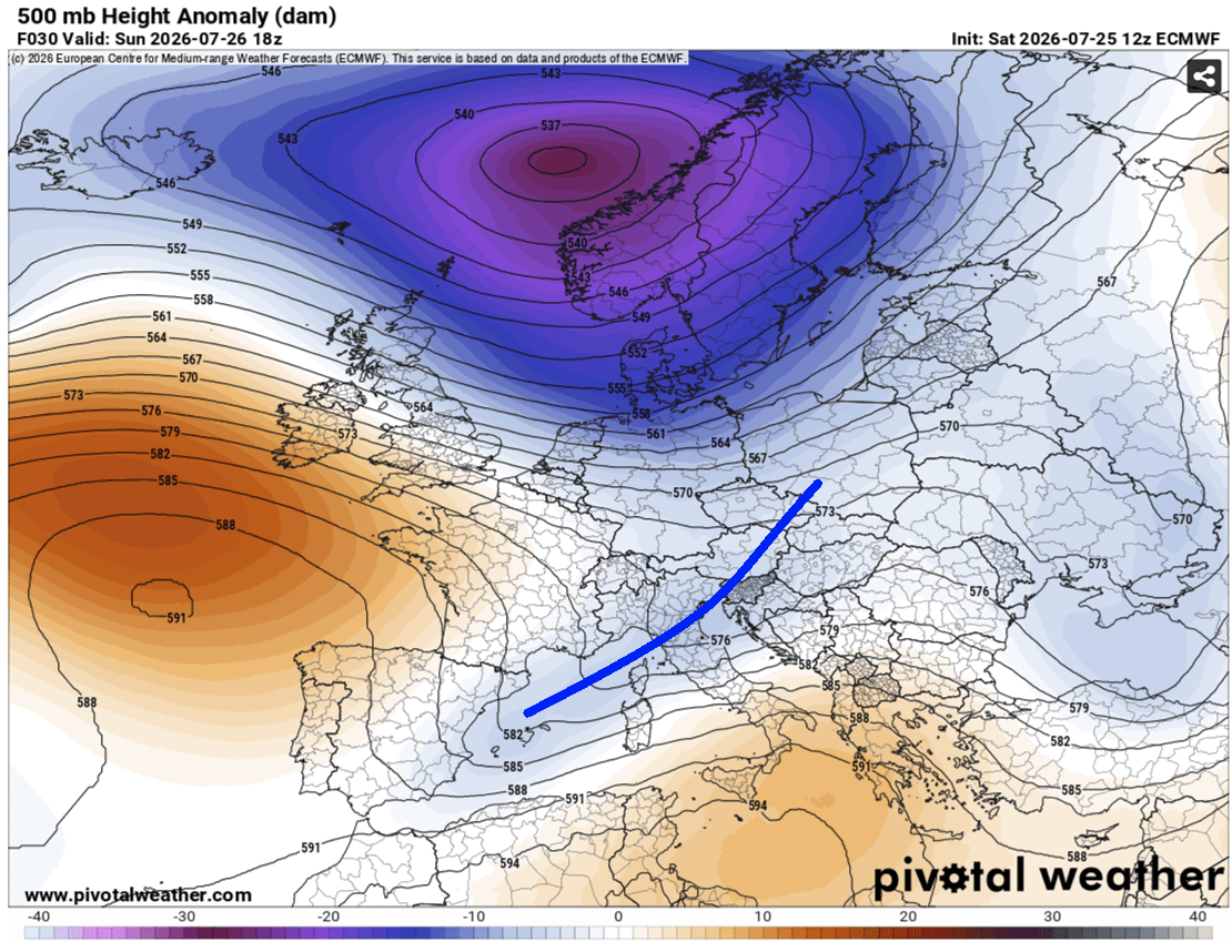
Forecasters have mapped out distinct hazard zones utilizing high-resolution atmospheric models (including inputs from Meteoadriatic, Wxcharts, and PivotalWeather). The highest-tier HIGH and MDT (Moderate) risk zones outline the regions facing the most extreme manifestations of the severe weather outbreak.
Primary HIGH Risk Zones
- Central and Northern Italy into the Central Adriatic Sea: This zone faces the full spectrum of severe weather threats. Forecasters warn of severe damaging winds, very large to giant hail, torrential rainfall capable of triggering severe flash floods, and a notable risk of tornadoes.
- Northeast Adriatic Sea, Northwest Croatia (Istria), and Southwestern Slovenia: This second HIGH risk area is primarily anchored by an extreme flash-flooding and heavy rainfall threat, alongside severe straight-line winds, large hail, and potential waterspouts or landfalling tornadoes.
Surrounding MDT, ENH, and SLGT Risks
Surrounding the core danger areas, Moderate (MDT), Enhanced (ENH), and Slight (SLGT) risks have been designated for southern and western Croatia, western and central Slovenia, west-central Austria, southern Switzerland, and remaining portions of north-central Italy. While storm coverage here may be slightly lower than in the core purple-shaded HIGH risk zones, the individual storms that do form will still carry substantial threats of severe winds, large hail, and localized torrential downpours.
Secondary Outbreak Zones Across Europe
While the Mediterranean basin bears the brunt of the outbreak, secondary severe weather threats have been identified elsewhere on the continent:
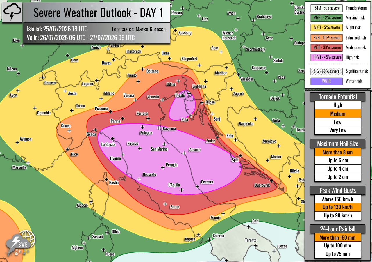
- Western Mediterranean (Northeast Spain and Balearic Islands): An ENH risk has been established to monitor isolated severe storms capable of producing severe winds, large hail, and torrential rain along the southern edge of the shifting upper-level wave.
- Central Europe (Netherlands, Northern Germany to Poland): A SLGT risk highlights scattered storms capable of producing strong, gusty winds and marginal hail.
- Southwestern Russia: A large ENH/SLGT risk area has been declared. High instability combined with strong environmental shear will support discrete supercells capable of producing damaging winds, torrential rain, large hail, and a conditional tornado threat due to favorable low-level helicity.
Official Responses and Civil Protection Measures
In anticipation of the severe weather outbreak, emergency management and civil protection agencies across Italy, Slovenia, and Croatia are placing local responders on high alert.
The timing of the outbreak—occurring during the peak of the European summer tourism season—adds a critical layer of vulnerability. Coastal regions, particularly the heavily populated beaches and tourist hubs of the Istrian peninsula and the Italian Adriatic coast, are bracing for the sudden onset of severe conditions.
- Public Safety Advisories: Local municipalities are urging residents and tourists to secure outdoor property, recreational equipment, and marine vessels. Campers and hikers in mountainous regions (the Apennines and the Alps) have been strongly advised to postpone outdoor excursions due to the extreme flash flood and lightning risks.
- Transport and Infrastructure Warnings: Aviation, maritime, and ground transport authorities are preparing for potential delays and cancellations. High winds and sudden convective gusts pose significant hazards to regional ferry services across the Adriatic and Ligurian seas, while torrential downpours threaten to temporarily overwhelm urban drainage systems and inundate major roadways.
Implications: Climate Context and Infrastructure Vulnerability
This upcoming severe weather event underscores the volatile nature of the current European summer. The juxtaposition of persistent, record-breaking marine heatwaves across the Mediterranean and energetic upper-level troughs plunging from northern Europe provides an almost textbook recipe for explosive convective development.
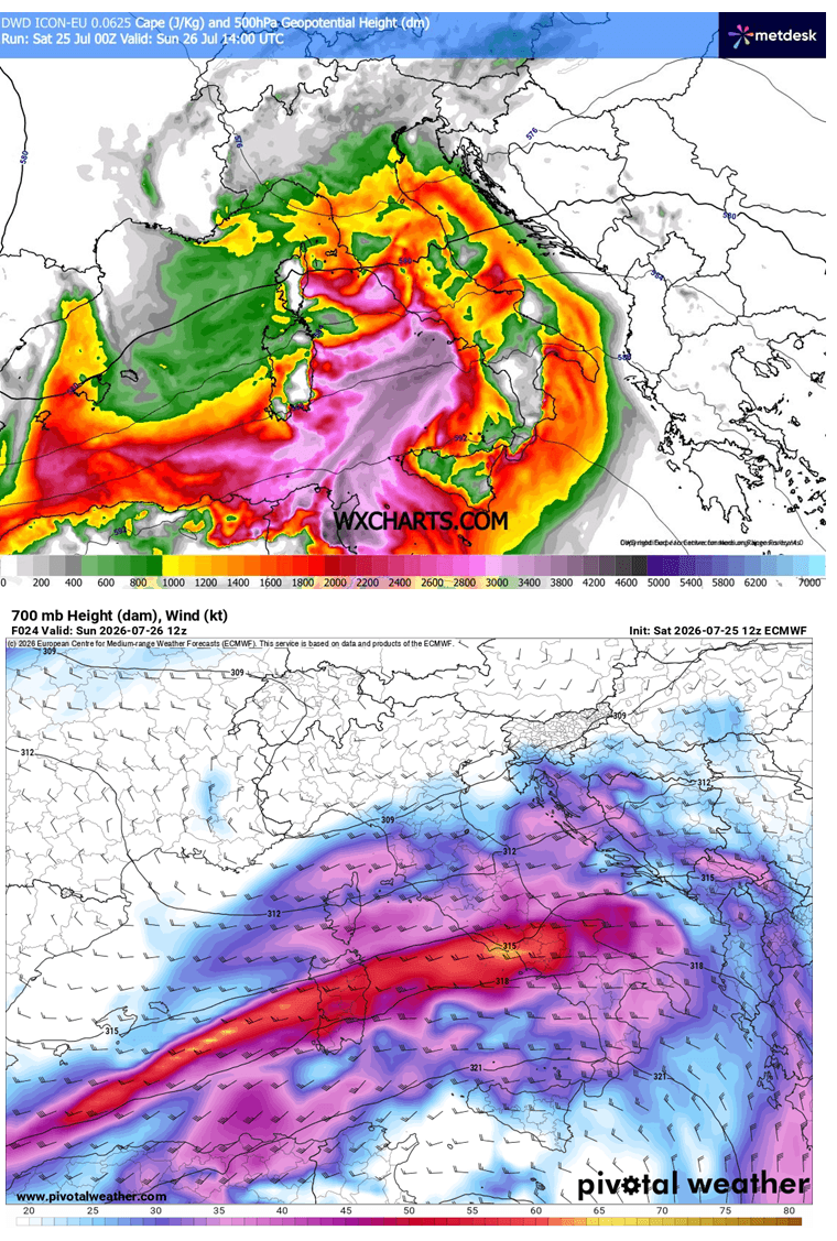
When extreme sea-surface temperatures supply an overabundance of moisture and thermal energy—quantified here by MLCAPE values exceeding 3,000 J/kg—even standard frontal passages can transform into violent, multi-hazard outbreaks.
As the climate continues to warm, meteorologists note that the capacity of the atmosphere to hold moisture increases exponentially, frequently resulting in the high-PWAT environments (45–60 mm) observed in this forecast. For regions like northern Italy and the Adriatic, these dynamics mean that heavy rainfall events are increasingly characterized by high-intensity, short-duration downpours that strain modern stormwater infrastructure.
Civil authorities and meteorological networks will continue to monitor real-time radar and satellite data closely as the event unfolds, issuing localized short-term warnings (nowcasts) as individual supercells and storm clusters materialize. Residents and travelers within the highlighted risk zones are strongly advised to monitor official national weather service channels and heed all evacuation or safety directives issued by local civil protection authorities.
