

ISSUE DATE: August 26, 2026
VALID PERIOD: August 27, 2026, 06:00 UTC – August 29, 2026, 06:00 UTC
ISSUED BY: Severe Weather Europe
LEAD FORECASTER: Marko Korošec
1. Main Facts: The Impending Continental Weather Crisis
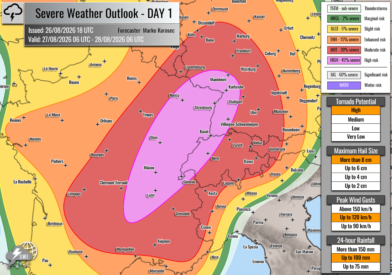
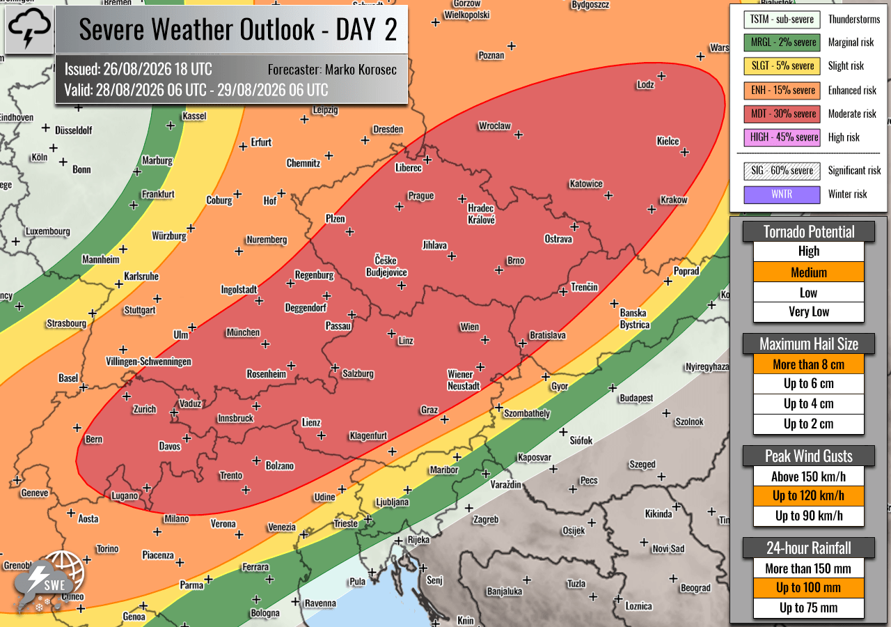
Millions of residents across Western and Central Europe are bracing for a severe, multi-day weather outbreak set to unfold between Thursday, August 27, and Friday night, August 28, 2026. Forecasters at Severe Weather Europe, led by renowned meteorologist Marko Korošec, have issued rare HIGH and Moderate (MDT) risk warnings covering portions of France, Switzerland, Germany, Austria, the Czech Republic, and Poland.
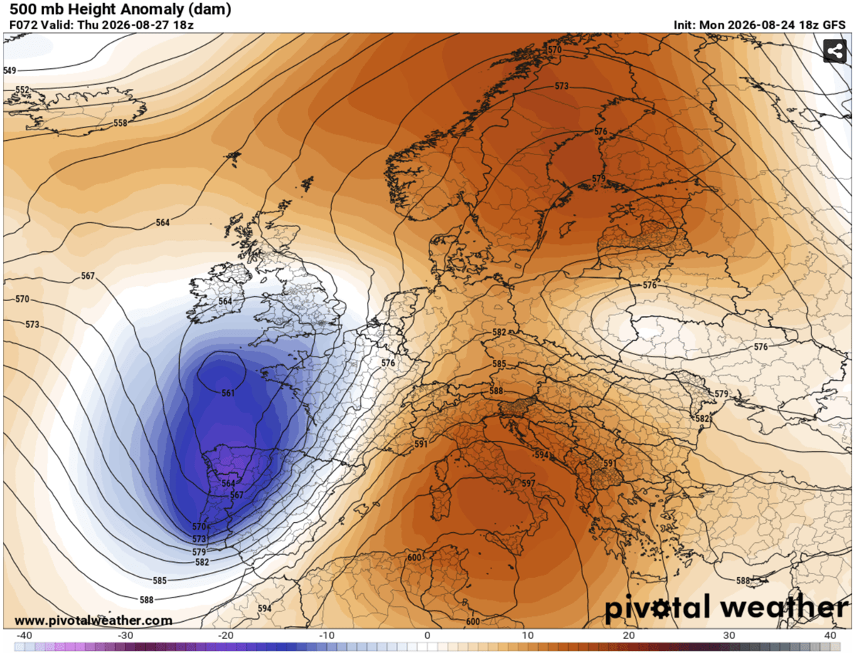
The primary atmospheric drivers for this disruptive event include a massive, deep upper-level trough pushing out of the Atlantic into Western Europe, interacting with a persistent, strong blocking high-pressure system anchored over the Mediterranean. Trapped between these two contrasting synoptic features is a powerful, southwesterly jet stream pumping exceptionally humid, unstable air northward from a heatwave-stricken Mediterranean basin.
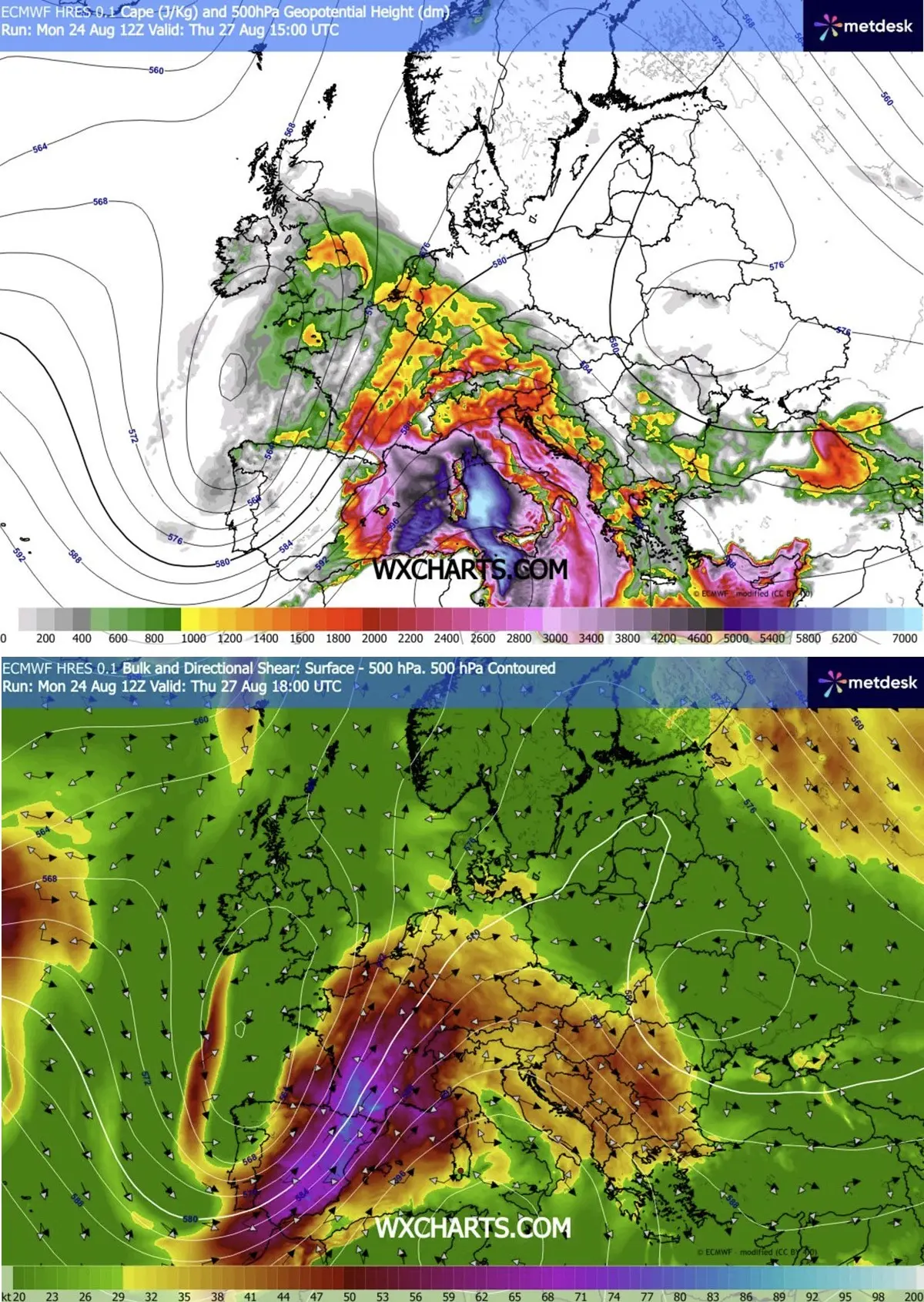
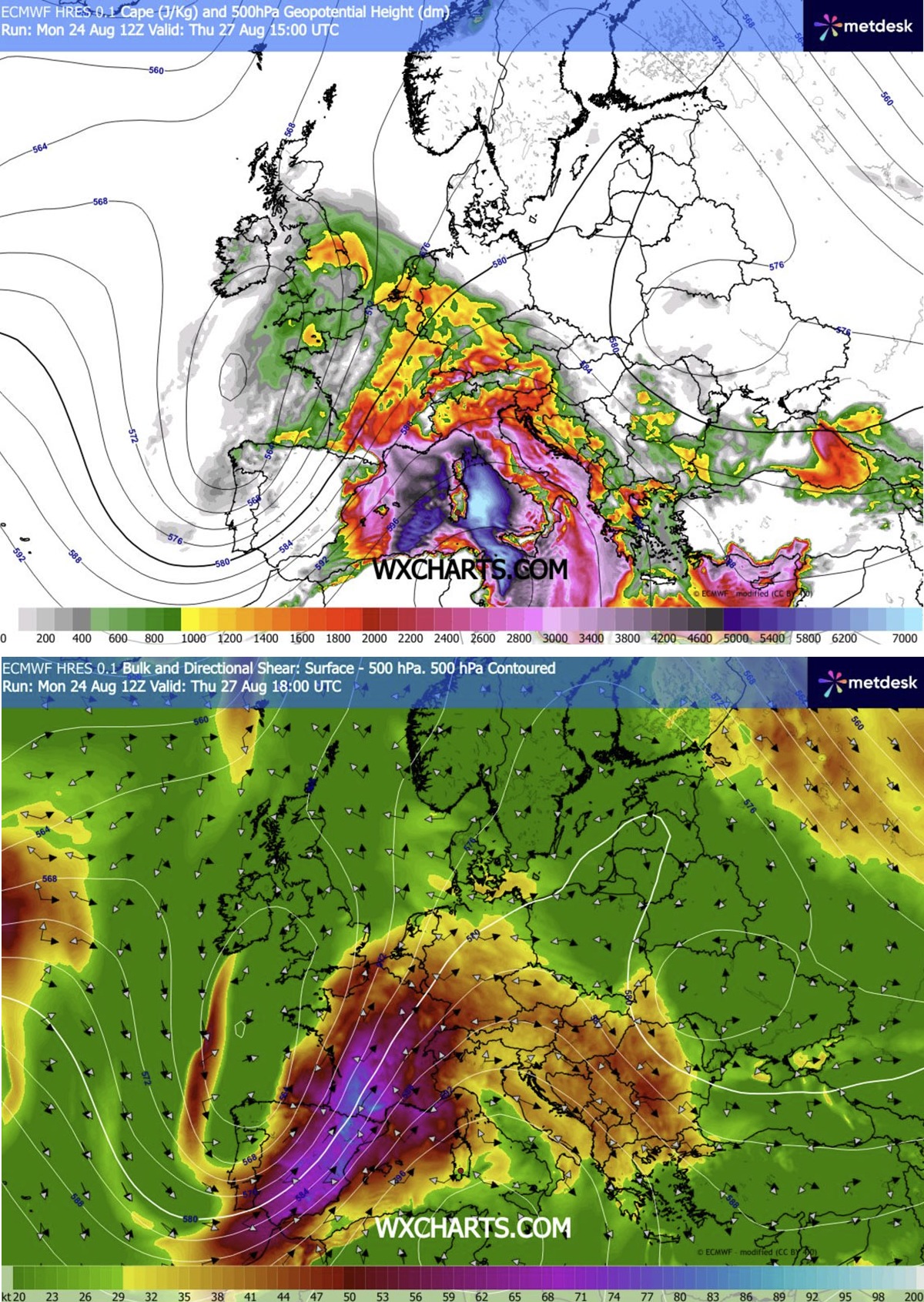
The combination of extreme atmospheric instability (with Convective Available Potential Energy—or MLCAPE—reaching staggering values of 2,000 to over 4,000 J/kg) and violent wind shear creates an explosive recipe for severe convective storms.
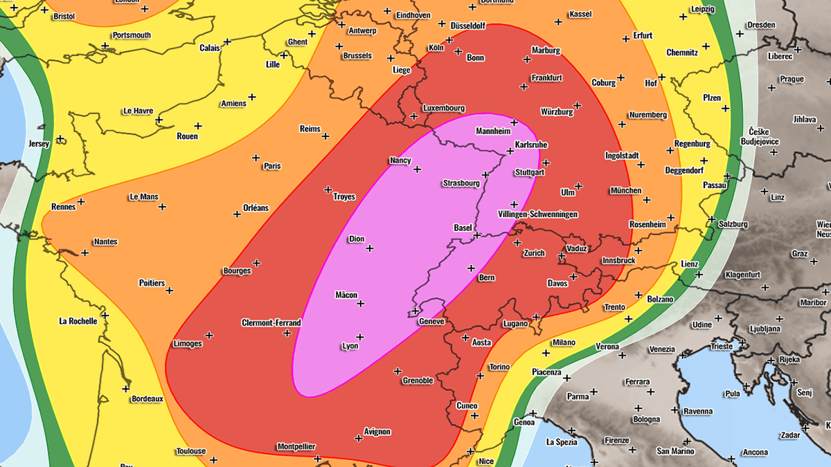
Residents and emergency management agencies in the risk zones have been put on high alert for a full spectrum of severe weather hazards, including:
- Very large to giant hail: Stones measuring 6 to 10 cm (or even larger) capable of destroying vehicles, shattering glass, and heavily damaging infrastructure.
- Destructive straight-line winds: Severe wind gusts potentially exceeding 120 km/h (75 mph), capable of uprooting trees and causing widespread structural damage.
- Tornadoes: Enhanced low-level shear and high storm-relative helicity, particularly in targeted valley regions, raising the risk of localized tornadic activity.
- Flash flooding: Torrential, excessive rainfall rates threatening urban and rural areas alike with sudden, dangerous floods.
2. Chronology of Events: A Two-Day Progression
The severe weather threat is structured as a dynamic, rolling event that will track eastward across the continent over a 42-hour window.
Thursday, August 27: France, Switzerland, and Southwestern Germany
The outbreak kicks off in earnest on Thursday midday. As the upper-level trough advances, surface heating coupled with moisture advection from the Mediterranean will trigger the explosive initiation of thunderstorms over the rugged terrain of the Massif Central in France.
- Early Afternoon to Late Afternoon: Storms will rapidly propagate into the Rhône Valley, where low-level southerly winds will maximize moisture transport. Isolated, highly violent supercells are expected to dominate this phase, bringing threats of giant hail, severe winds, and a localized tornado threat—particularly maximized in the Rhône Valley due to peak storm-relative helicity.
- Evening: As the afternoon progresses into evening, these discrete supercells will race east-northeastward, driven by intense mid-level winds aloft. They will cross into western Switzerland and southwestern Germany. By nightfall, the storms are forecast to merge into large, cohesive clusters or a Mesoscale Convective System (MCS), carrying the threat of severe wind-driven hail and damaging straight-line winds deep into central Germany.
- Secondary Threat Areas: Simultaneously, a secondary axis of storm development is expected to take shape further north, moving toward the Benelux union and western Germany by late afternoon and evening. Southern England could also experience isolated severe storms during peak heating as the upper wave passes overhead.
Friday, August 28: The Alps, Czech Republic, and Poland
The focus of the severe weather shifts eastward on Friday as the cold front continues its slow, grinding push toward Central and Eastern Europe.
- Early Afternoon: Isolated to scattered thunderstorms are expected to ignite over the high terrain of the Alps by early afternoon. Backed by moderately strong instability and robust wind shear, these storms will initially take the form of intense multicells and supercells.
- Late Afternoon to Evening: A critical phase of the outbreak unfolds as these storms cluster together. High-resolution numerical weather prediction models indicate a significant risk that these clusters will evolve into an aggressive Mesoscale Convective System (MCS) sweeping from southeastern Germany and northeastern Austria into the southwestern Czech Republic.
- Overnight into Saturday: As bowing line segments within the MCS develop, forecasters warn of a severe wind-gust threat capable of producing widespread structural damage exceeding 120 km/h. This complex of storms will continue tracking northeastward into southwestern Poland overnight before finally beginning to weaken toward Saturday morning.
3. Supporting Meteorological Data and Synoptic Overview
To understand the severity of this upcoming outbreak, meteorologists look closely at the large-scale atmospheric setup and thermodynamic parameters.
Synoptic Pattern
The macro-scale weather map reveals a classic setup for severe convective outbreaks in Europe. A pronounced upper-level ridge is currently building across the Mediterranean, Central Europe, and the Balkans. Simultaneously, a deep trough digging over western Iberia sets up a sharp pressure and temperature gradient across the continent.
This tight gradient supercharges the southwesterly jet stream, extending from eastern Spain, across the western Mediterranean, and directly into southern and eastern France. This jet stream provides the vital ingredient of deep-layer wind shear—the change in wind speed and direction with height—which allows updrafts within thunderstorms to tilt, separate from downdrafts, and sustain themselves for hours.
Thermodynamic Instability (CAPE)
Beneath the powerful jet stream, the airmass is exceptionally moisture-laden. Thanks to an ongoing, intense heatwave across the Mediterranean basin, sea-surface and coastal temperatures have driven dewpoints to unusually high levels. When this warm, moist air is lifted into the atmosphere, it encounters cooler mid-level air, creating extreme buoyancy.
Forecast soundings indicate MLCAPE values ranging widely from 2,000 J/kg to well over 4,000 J/kg across southeastern France on Thursday. Values of this magnitude are more commonly associated with severe weather outbreaks in the American Great Plains than standard European summer storms, indicating an environment capable of producing ferocious vertical updrafts.
Model Guidance and Verification
Forecasters have utilized high-resolution modeling suites, including specialized WRF (Weather Research and Forecasting) model runs, alongside data visualizations provided by Meteoadriatic, Wxcharts, and PivotalWeather. While the thermodynamic instability and wind shear parameters are universally agreed upon by models, slight timing uncertainties remain regarding the precise upscale growth and longevity of the Friday night MCS over the Czech-German borderlands—a common forecasting challenge in complex Alpine terrain.
4. Official Responses and Preparedness
In anticipation of the severe weather impacts, civil protection agencies, local municipalities, and national meteorological services across the affected countries have begun issuing safety advisories and pre-positioning emergency response units.
- France: Météo-France and regional prefectures have urged residents in eastern and southern departments to secure outdoor property, avoid unnecessary travel during peak storm hours, and monitor local alerts closely. Emergency services are on standby for potential water rescues in flash-flood-prone zones and rapid clearance of fallen timber.
- Germany and Switzerland: Authorities in southwestern Germany and western Switzerland are coordinating cross-border communication regarding potential highway hazards. Motorists have been warned about the dangers of hydroplaning and sudden whiteout conditions caused by torrential downpours and wind-driven hail.
- Austria, Czech Republic, and Poland: Disaster management frameworks in Central Europe are reviewing protocols for agricultural and infrastructure protection. Farmers have been advised to shelter livestock and secure loose equipment, while municipal workers are clearing storm drains to mitigate urban flash flooding.
Aviation and rail authorities have also warned passengers to expect significant delays, ground stops, and cancellations starting Thursday afternoon through Friday night, as severe convective cells cross major European transit corridors.
5. Implications: Infrastructure, Agriculture, and Climate Context
Beyond the immediate danger to human life and safety, an outbreak of this scale carries profound socio-economic implications for Western and Central Europe.
Agricultural and Economic Toll
With giant hail (6–10 cm+) predicted in multiple zones, the agricultural sector faces severe vulnerability. Vineyards in France and Germany, orchards in the Alpine foothills, and staple crop fields across the Czech Republic and Poland risk catastrophic damage just weeks ahead of the autumn harvest. Greenhouses, commercial signage, and civilian vehicles parked in the open will likely suffer extensive, costly destruction.
Power Grids and Transport Networks
Straight-line winds gusting up to or exceeding 120 km/h pose a severe threat to overhead electrical transmission lines. Widespread, multi-day power outages could affect hundreds of thousands of households and industrial facilities. Furthermore, major European transport arteries—including key sections of the trans-European highway network and high-speed rail lines connecting Paris, Zurich, Munich, and Prague—face major disruptions from downed trees, debris, and localized flooding.
The Broader Climate Picture
Meteorologists note that while severe thunderstorms are a natural feature of late-summer transitions in Europe, the intensity of this event is amplified by abnormally warm sea-surface temperatures in the Mediterranean. Unprecedented marine heatwaves provide an abundant reservoir of latent heat and moisture, feeding convective systems with energy levels that push historical meteorological boundaries.
As the outbreak unfolds over the next 48 hours, residents within the HIGH and MDT risk zones are strongly advised to stay tuned to local meteorological broadcasts, heed warnings issued by civil protection authorities, and ensure they have a safe shelter plan in place before storms arrive.
