

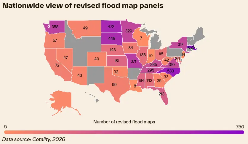
NATIONAL REPORT — Thousands of American residential property owners are facing an urgent financial reckoning following sweeping updates to the Federal Emergency Management Agency’s (FEMA) flood maps. According to a recent risk intelligence alert issued by business intelligence provider Cotality, the newly redrawn maps have pulled thousands of properties—previously considered low-to-moderate risk—directly into the high-risk Special Flood Hazard Area (SFHA).
The administrative shift is more than just a cartographic update; it carries immediate, mandatory legal and financial consequences. Homeowners residing within these newly designated zones now face a strict 45-day window to secure compliant flood insurance policies or risk severe disruptions to their mortgage servicing, escrow accounts, and overall financial stability.
While the updates aim to provide a more accurate, scientifically rigorous picture of America’s escalating climate and weather risks, critics and housing advocates warn that the abrupt rollout threatens to squeeze vulnerable borrowers already grappling with an affordability crisis.
Main Facts: The Scope and Mandate of the FEMA Map Revisions
The latest updates affect more than 100 communities spread across 12 states, instantaneously transforming the insurance and lending landscape for property owners in those regions.
Under federal regulations, properties backed by federally regulated or insured mortgages that are mapped into an SFHA are legally required to carry continuous flood insurance. When a map revision places an existing structure into this high-risk designation, mortgage lenders are legally obligated to enforce this requirement. Homeowners typically receive a notice informing them that they must prove coverage within a tight 45-day compliance window. Failure to do so grants the loan servicer the right to force-place flood insurance—a costly alternative that is often significantly more expensive than standard policies purchased on the open market.
The financial friction caused by this mandate cannot be overstated. For many families, an unexpected flood insurance bill ranging from several hundred to several thousand dollars a year represents the tipping point of household insolvency.
Cotality’s data underscores a fragile economic reality underpinning the housing market: for roughly 10% of homeowners nationwide, the monthly amount paid into escrow accounts—which covers property taxes, homeowners insurance, and hazard policies—already eclipses the principal and interest portion of their monthly mortgage payment. Forcing a sudden, new mandatory insurance premium into this equation threatens to price vulnerable families out of their homes.
Chronology of the Crisis: From Science to Sudden Enforcement
To understand how thousands of homeowners find themselves racing against a 45-day clock, it is necessary to examine the timeline of risk assessment, mapping, and policy implementation.
Phase One: Risk Identification and Mapping
FEMA continually updates its Flood Insurance Rate Maps (FIRMs) to reflect changing environmental realities, shifting weather patterns, coastal erosion, and urban development that alters natural drainage basins. These maps are the result of years of topographical studies, hydrological modeling, and historical data analysis. As climate change accelerates the frequency and intensity of severe precipitation events and coastal storm surges, these updates increasingly expand the boundaries of high-risk zones.
Phase Two: The Notification Gap
Once FEMA finalizes and adopts a map update, the transition period hits the consumer market. However, a systemic vulnerability exists within this phase: change notifications are not universally or strictly mandated across all jurisdictions in a way that guarantees direct, timely consumer outreach. According to Cotality, many homeowners are left entirely in the dark, discovering the reclassification only when they receive a blunt, urgent letter from their mortgage servicer demanding proof of flood insurance within 45 days.
Phase Three: The 45-Day Scramble
Upon receiving the lender notice, the 45-day countdown begins. Homeowners must scramble to secure Elevation Certificates (often requiring a paid professional surveyor), shop for quotes through the National Flood Insurance Program (NFIP) or private markets, and navigate the bureaucratic requirements of their lenders. For families living paycheck to paycheck, securing hundreds or thousands of dollars for a down payment on a new policy within weeks is an extraordinary hardship.
Supporting Data: Where the Impact Hits Hardest
The geographic distribution of these map updates spans diverse regions, touching both coastal states historically vulnerable to hurricanes and inland communities susceptible to riverine flooding and flash floods.
Cotality’s data highlights the top five communities and counties most heavily impacted by properties newly mapped into the SFHA:
| Location | Number of Properties Mapped into SFHA |
|---|---|
| Escambia County, Florida | 2,344 |
| Pender County, North Carolina | 678 |
| Chattanooga, Tennessee | 635 |
| Ithaca, New York | 428 |
| Methuen, Massachusetts | 428 |
Data source: Cotality, 2026
The inclusion of inland municipalities such as Chattanooga, Tennessee; Ithaca, New York; and Methuen, Massachusetts, demonstrates that this is not exclusively a coastal phenomenon. Inland river basins, aging municipal stormwater infrastructure, and shifting weather tracks are increasingly exposing non-traditional markets to severe flood hazards.
Furthermore, historical delinquency data analyzed by risk firms in Gulf Coast states—including Louisiana, Mississippi, and Texas—reveals a stark, undeniable correlation: spikes in environmental disasters and subsequent insurance premium hikes directly precede surges in mortgage defaults and foreclosures. When insurance costs spike, default rates follow closely behind.
Official Responses and Industry Perspectives
As the pressure mounts on homeowners and mortgage lenders alike, stakeholders across the housing and insurance sectors are weighing in on the dual imperatives of accurate risk disclosure and financial preservation.
The Science of Survival
Industry experts argue that while the rollout is painful, ignoring the reality of environmental risk is ultimately more destructive.
"Stability is invaluable, and having the most accurate view of risk will mean millions more homeowners are prepared when the storm inevitably arrives," said Howard Botts, Cotality’s chief scientist. "Preparation leads to community resilience, which can lessen the burden of recovery."
Botts and other scientists emphasize that outdated flood maps offer a false sense of security. Homeowners who believe they are safe because they sit outside a 50-year-old flood zone boundary are often financially ruined when a 500-year flood event strikes their neighborhood without insurance backing.
The Lender’s Burden and Consumer Protection
From a systemic standpoint, financial institutions are under increasing pressure from regulators to account for climate risk in their long-term portfolios. Mortgage loan providers must forecast future environmental outcomes to protect not only their own balance sheets but also to safeguard consumers from purchasing properties that carry hidden, unsustainable long-term ownership costs.
However, housing advocates argue that lenders and federal agencies must do more to bridge the communication gap. Leaving notification policies fragmented means that lower-income homeowners—particularly those utilizing Federal Housing Administration (FHA) loans who operate with narrower financial margins—bear the brunt of the shock without adequate time to plan or budget.
Broad Implications: The Future of American Housing and Insurance
The intersection of updated FEMA flood maps, mandatory insurance rules, and a strained housing market carries profound long-term implications for the United States.
1. Affordability and the Housing Market
As hazard zones expand, the total cost of homeownership rises invisibly. Properties newly designated as high-risk may experience downward pressure on market values, as prospective buyers factor in the permanent, recurring cost of expensive flood insurance policies. For current owners, these added costs threaten to trigger involuntary displacement through defaults or forced sales.
2. The Evolution of Insurance Availability
With traditional insurers pulling back from high-risk environmental zones across California, Florida, and the Gulf Coast, the burden increasingly falls on state-backed insurers of last resort and the federal NFIP. As map updates push more properties into the SFHA, the demand on these systems will skyrocket, testing the financial limits of public-backed disaster insurance programs.
3. Toward Proactive Resilience
Ultimately, the latest FEMA map revisions and the Cotality alert serve as a loud wake-up call to the American real estate ecosystem. Experts agree that the solution cannot simply be reactionary—hitting homeowners with a 45-day compliance notice.
Instead, a holistic overhaul is required: one that combines transparent, long-term risk disclosures before a property is purchased, federal assistance or transitional subsidies for low-income FHA borrowers facing sudden map changes, and aggressive community-level infrastructure investments to mitigate flood risks at the source.
Until such systemic reforms take root, thousands of homeowners across America will continue to live in the crosshairs of climate data and administrative mandates, racing against the clock to protect their homes and their financial futures.
