

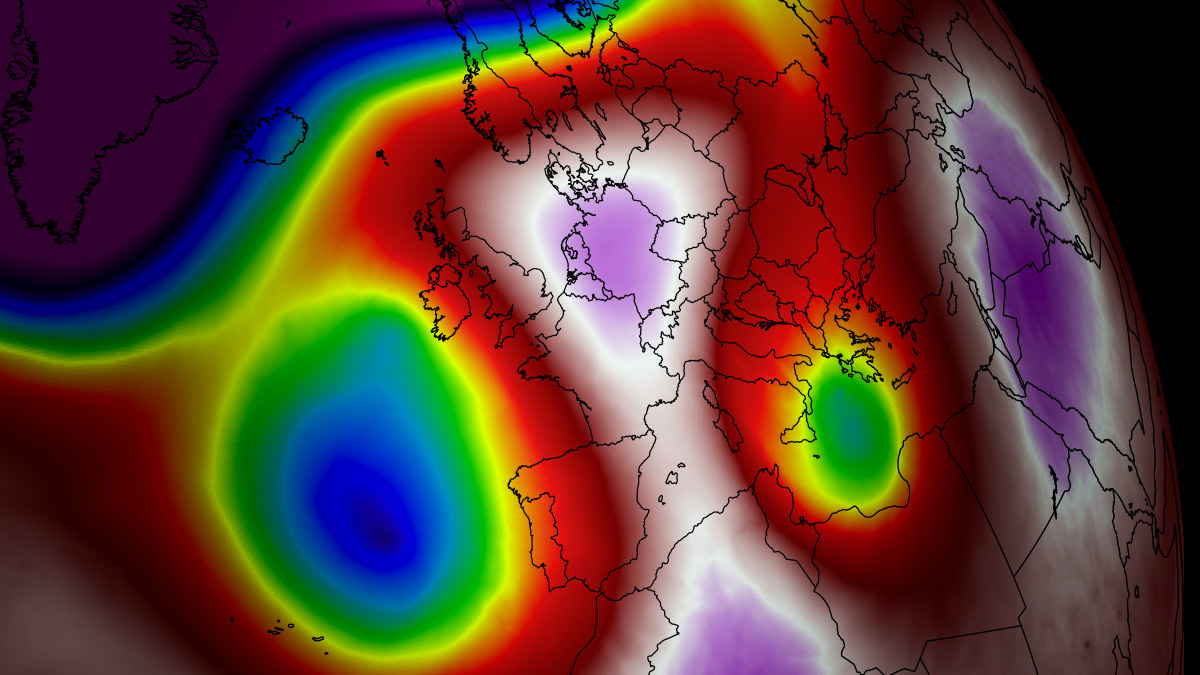
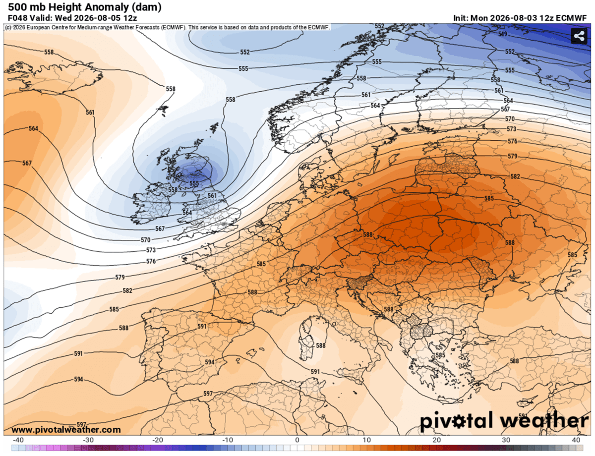
EUROPE — A sprawling, high-amplitude upper-level ridge is firmly expanding eastward across Central Europe and the Balkan Peninsula, locking in a widespread, punishing heatwave that will see daytime highs surge past the 40°C (104°F) mark through the first week of August. Driven by a persistent and intense "Heat Dome" synchronized with an Omega block atmospheric pattern, an exceptionally warm and dry air mass is continuously surging northward from North Africa.
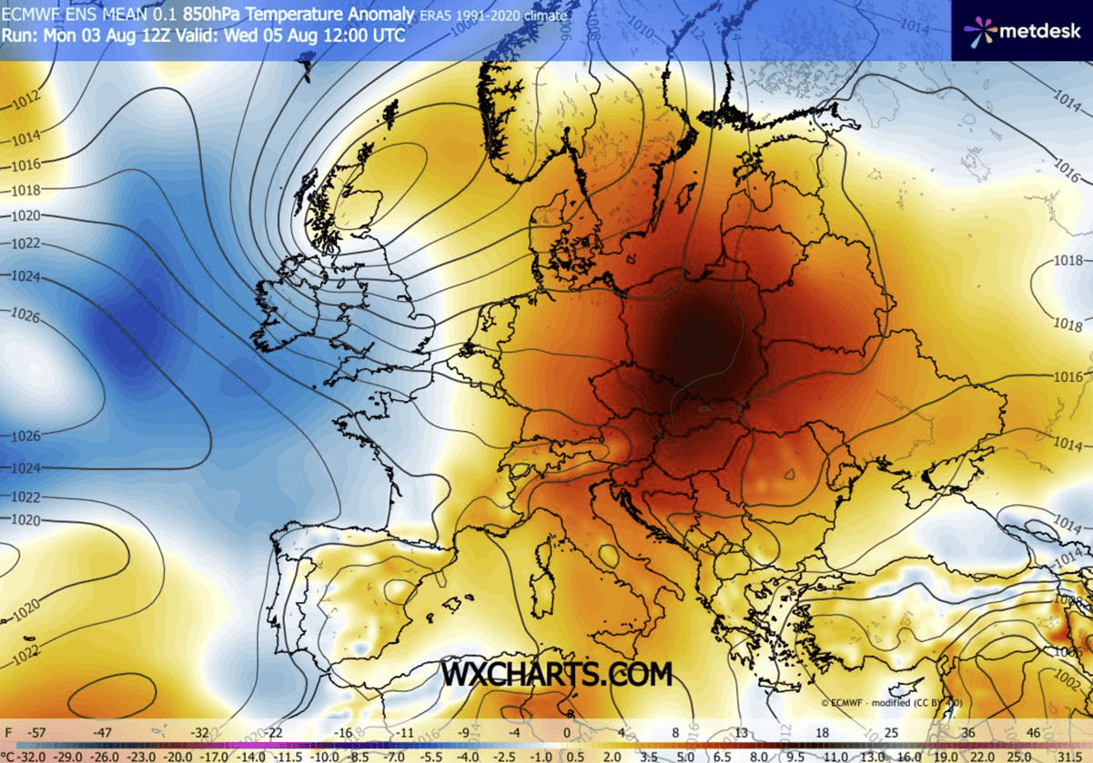
According to meteorological data, upper-air thermal anomalies are being pushed into the 99th percentile across northern Italy, Hungary, Croatia, Serbia, and surrounding regions. With baking river basins, suffocating "tropical nights," and compounding risks to agriculture and public health, authorities across the continent are bracing for a week of extreme atmospheric stress.

Main Facts: The Anatomy of the August Heatwave
The primary atmospheric engine driving this multi-week thermal event is a stubborn, stationary high-pressure system parked directly over the heart of the continent.
- The Mechanism: As sinking air compresses and warms the lower troposphere, it acts like a lid on a pot, trapping heat at all levels. This adiabatic compression results in surface temperatures soaring into the 40°C to 43°C (103°F to 109°F) range across low-lying river basins, such as the Po Valley in Italy and the Pannonian Basin.
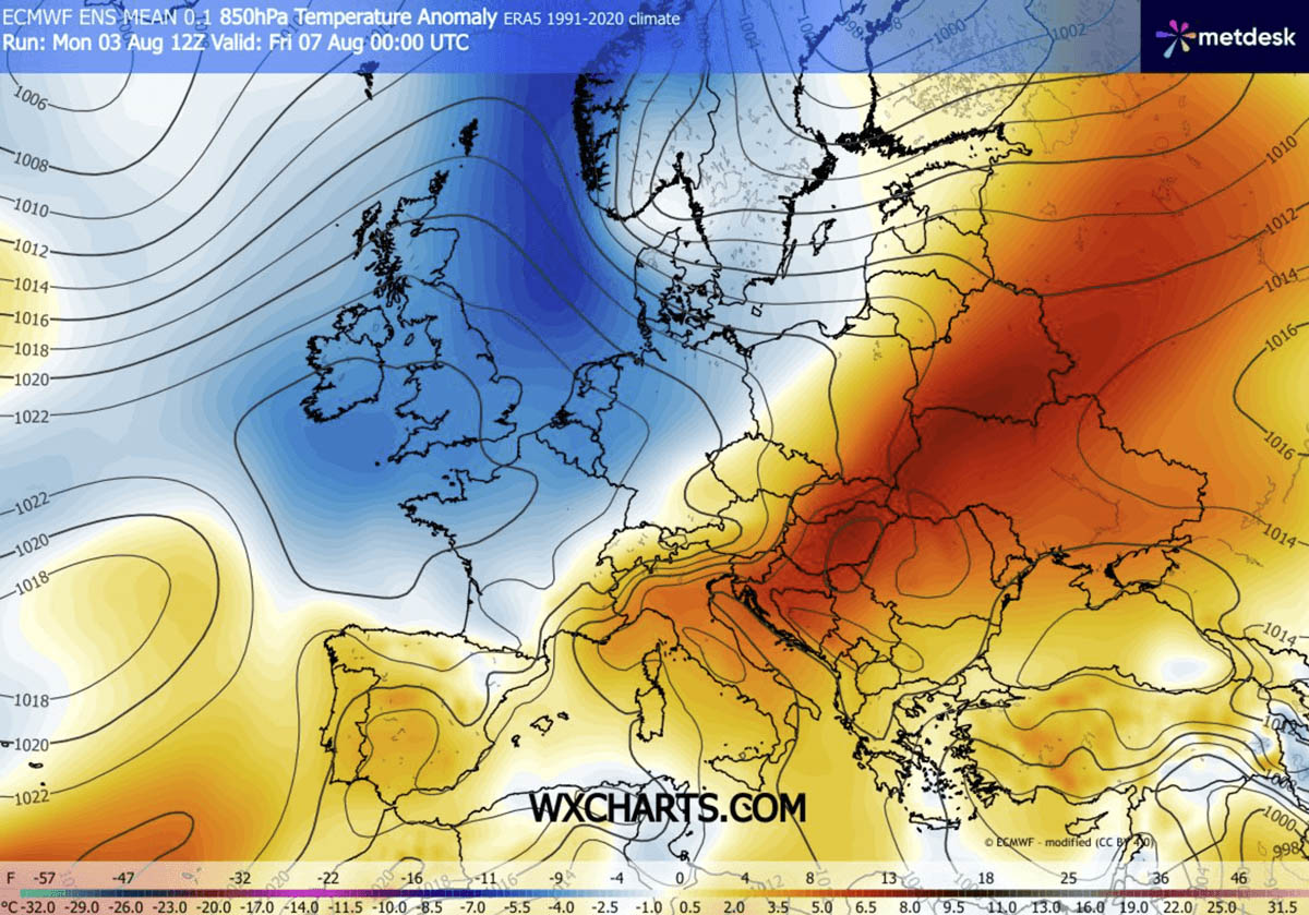
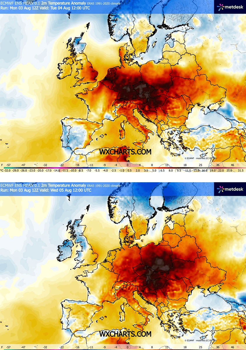
- Geographical Spread: The extreme anomalies are shifting eastward. Early-week peaks in Germany, the Czech Republic, and Austria are giving way to mid-and-late-week extremes across Hungary, Croatia, Serbia, Romania, Ukraine, and eventually expanding southward into Bulgaria and Greece.
- Nocturnal Relief Absent: One of the most dangerous aspects of the current weather pattern is the lack of overnight cooling. Major urban centers are recording minimum temperatures refusing to drop below 22°C to 26°C (72°F to 79°F), creating a string of hazardous "tropical nights."
- Dry Winds and Drought: Continental dry winds are exacerbating the crisis by keeping relative humidity low while aggressively accelerating soil moisture loss, setting the stage for explosive wildfire conditions across Southern Europe and the Western Balkans.
Chronology: Progression of the Synoptic Setup
The evolution of this massive weather event follows a distinct, multi-day trajectory dictated by the interaction between the blocking high over Central Europe and an advancing upper-level wave in the West.
Early Week: Central Europe Takes the Brunt
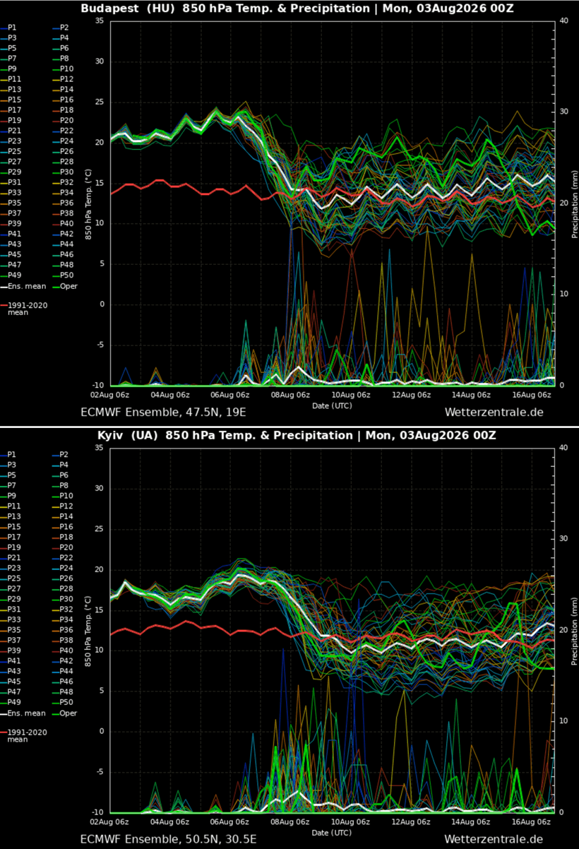
The weather pattern early in the week featured a persistent strong upper-level ridge sitting squarely over Central Europe. On Tuesday, countries like Germany, the Czech Republic, and eastern Austria experienced peak daytime highs ranging from 36°C to 40°C. However, the approach of an upper-level wave from the Atlantic began introducing cooler maritime air into Western Europe, slowly easing conditions in the UK, France, and parts of the Iberian Peninsula while compressing the core of the heat eastward.
Mid-Week: The Shift to the Pannonian Basin and Balkans
By Wednesday and Thursday, the core of the anomalous temperatures shifted eastward alongside the upper-level dome. The highest temperatures migrated into Croatia, northern Serbia, Hungary, and western Romania. The Pannonian Basin became a literal oven, with peak temperatures forecasted to hit 42°C to 43°C by Thursday, marking the most intense period of the heatwave for the northern Balkans and Eastern Europe.

Late Week: Expansion into Eastern Europe and Western Russia
As the upper-level ridge elongates further toward the end of the week, the extreme heat spreads into Ukraine, eastern Poland, southern Belarus, and eventually pushes southward into Bulgaria and Greece by Friday. Only the arrival of a shallow frontal boundary from the west late in the week promises any immediate sign of relief for the eastern fringes of the continent.
Supporting Data and Atmospheric Dynamics
To fully grasp the severity of this event, meteorologists point to the unique combination of the Heat Dome and the Omega block.
Understanding the Heat Dome
A heat dome forms when a broad, stagnant area of high pressure parks over a vast continental region for days or weeks. The upper high-pressure system forces air downward, compressing it and causing it to heat up rapidly. This creates a dome of trapped, scorching air at the surface.
The Heat Index and Humidity Factors
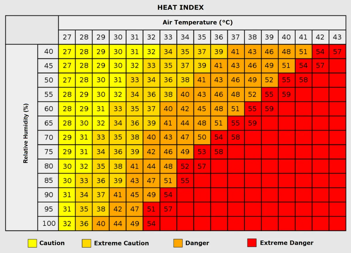
While dry heat is challenging, the interaction between temperature and humidity is critical for human physiology. The Heat Index calculates what temperatures feel like to the human body. For instance, an air mass measuring 35°C with moderate humidity is manageable, but if humidity spikes above 80%, the apparent temperature can skyrocket near 50°C (122°F), pushing the human body past its natural cooling limits through perspiration.
Official Responses and Societal Implications
The socio-economic and physiological toll of a heat event of this magnitude is profound, prompting swift warnings from civil protection agencies, health ministries, and labor organizations across affected nations.
Public Health and Vulnerable Populations
Health authorities have issued red-alert warnings for millions of residents. The elderly, young children, and individuals with pre-existing cardiovascular and respiratory conditions are at the highest risk of heat exhaustion, heat stroke, and cardiac events.
Furthermore, socioeconomic disparities play a deadly role during heat domes. Urban populations living in densely packed neighborhoods characterized by heat-trapping surfaces—such as concrete, asphalt, and older insulation materials—experience significantly higher indoor temperatures, compounding the danger of consecutive tropical nights where the body fails to recover.
Occupational Hazards and Agriculture
Outdoor workers, including agricultural laborers, construction crews, and delivery personnel, face extreme occupational hazards. Governments have mandated adjusted working hours, pausing heavy labor during peak afternoon irradiation periods.
Concurrently, the agricultural sector is sustaining heavy blows. Accelerated soil moisture loss threatens staple crops across the Pannonian and Po valleys, intensifying concerns over crop yields and food security as prolonged drought conditions tighten their grip.
Looking Ahead: Mid-Range Trends and Future Outlook
Even as the current heat dome begins to shift and eventually break down over Eastern Europe and the Balkans by the weekend, global ensemble forecast models are already signaling a concerning repetition of the pattern.
Mid-range meteorological trends indicate that yet another powerful high-pressure ridge could build across southwestern, western, and central Europe by next week. While precise positioning details remain fluid at a 10-day lead time, models suggest the development of a brand-new persistent Heat Dome.
This subsequent system threatens to reignite extreme heatwaves across Portugal, Spain, France, and the Alps, eventually crawling toward the British Isles and threatening to sustain anomalous heat conditions well into mid-August.
Meteorological services across Europe urge residents to remain vigilant, stay hydrated, and monitor official daily forecasts as the continent navigates one of its most volatile summer weather seasons on record.
