

Main Facts: The Convergence of Two Global Climate Drivers
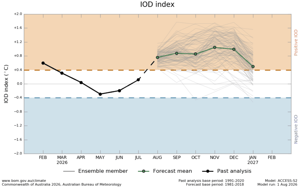
As the Northern Hemisphere transitions from late summer into the colder months, meteorologists are closely tracking a rare and potent meteorological alignment. A rapidly strengthening Super El Niño in the tropical Pacific is combining forces with an emerging positive Indian Ocean Dipole (IOD).

This synchronized dual-ocean climate engine is setting the stage for what seasonal forecasts predict will be a highly impactful Winter 2026/2027.
Unlike standard seasonal shifts driven by a single oceanic anomaly, the simultaneous presence of a historically powerful El Niño and a sustained positive IOD creates a massive, coupled atmospheric circulation response. Global climate models, including those from the European Centre for Medium-Range Weather Forecasts (ECMWF) and the National Centers for Environmental Prediction (NCEP), indicate that this combined tropical forcing will significantly alter jet stream patterns, storm tracks, and snowfall distributions across North America and Europe.
Key highlights of the developing Winter 2026/2027 outlook include:
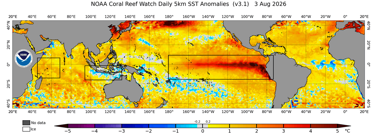
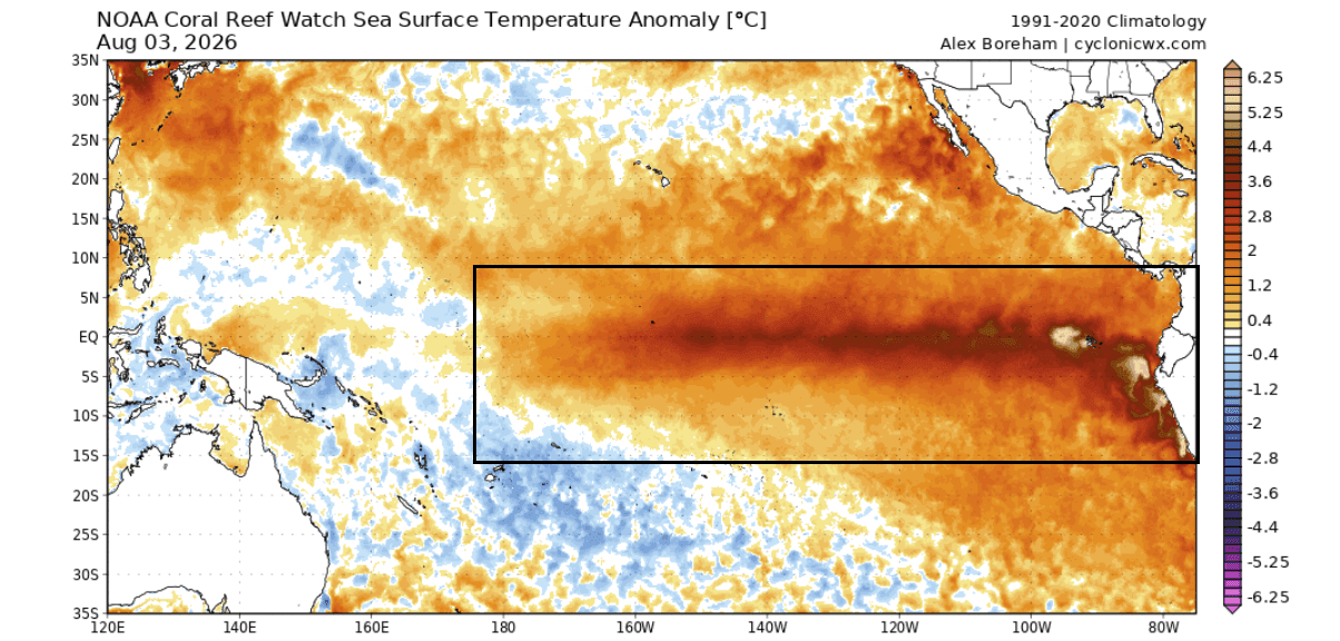
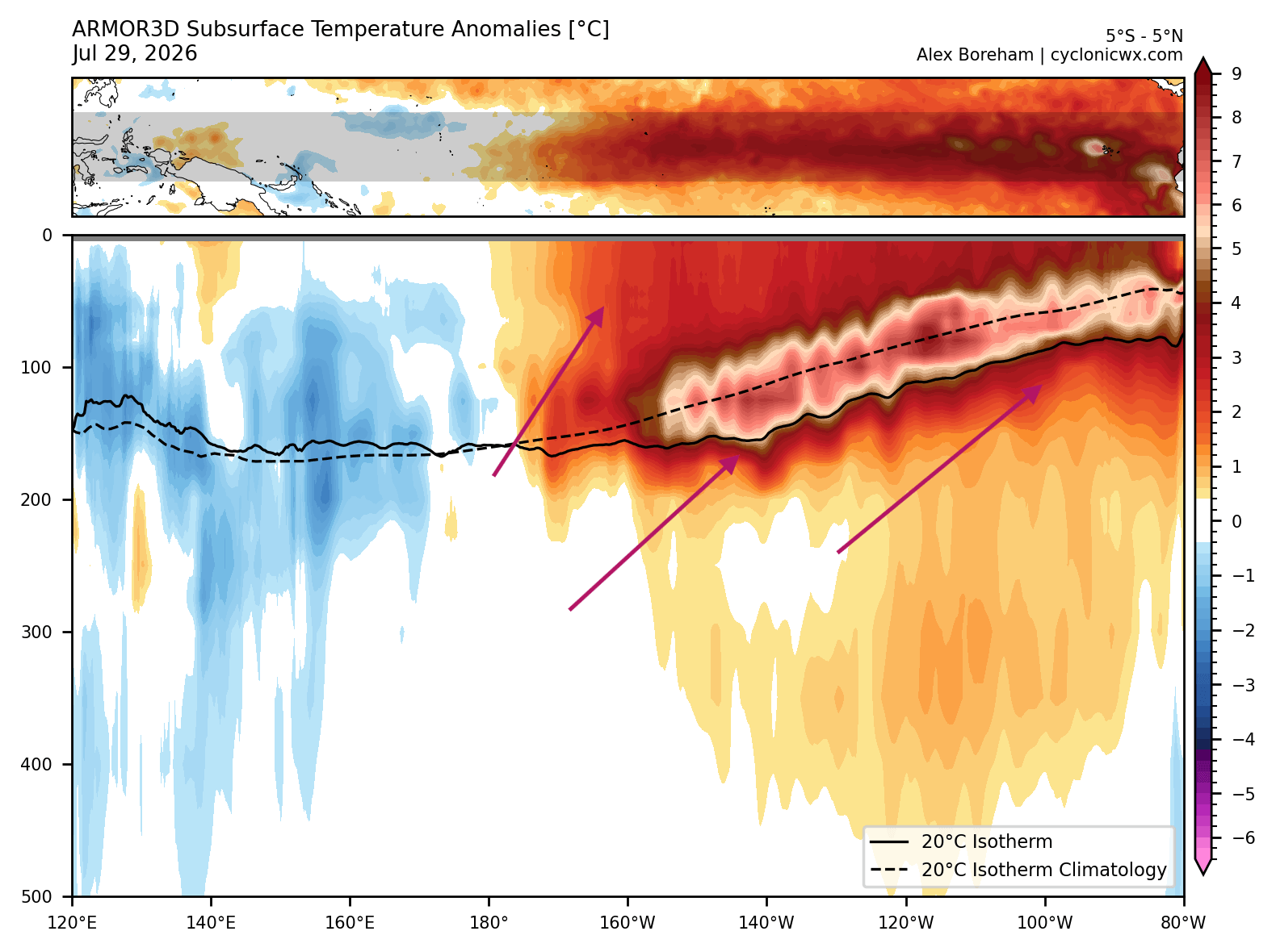
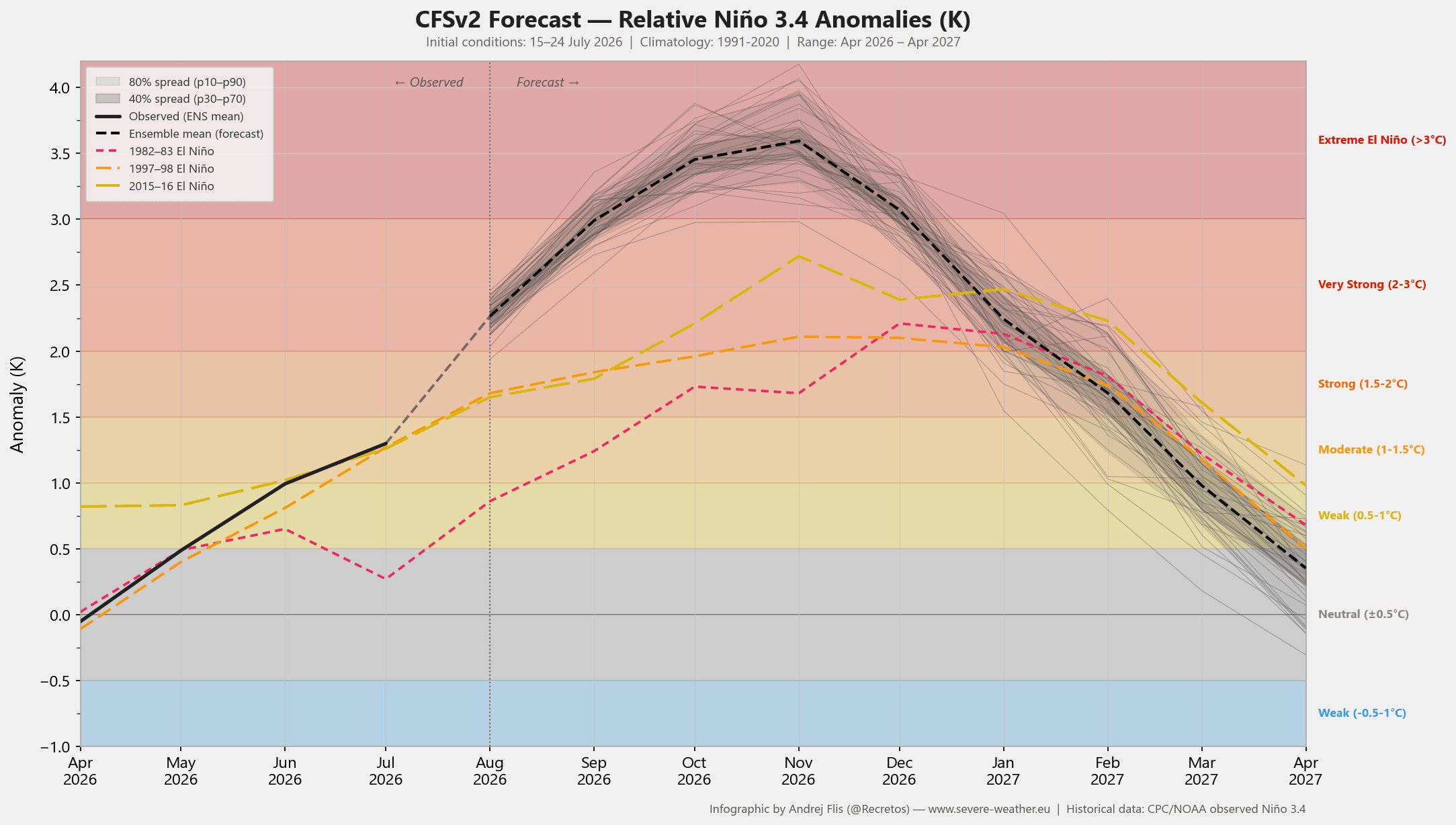
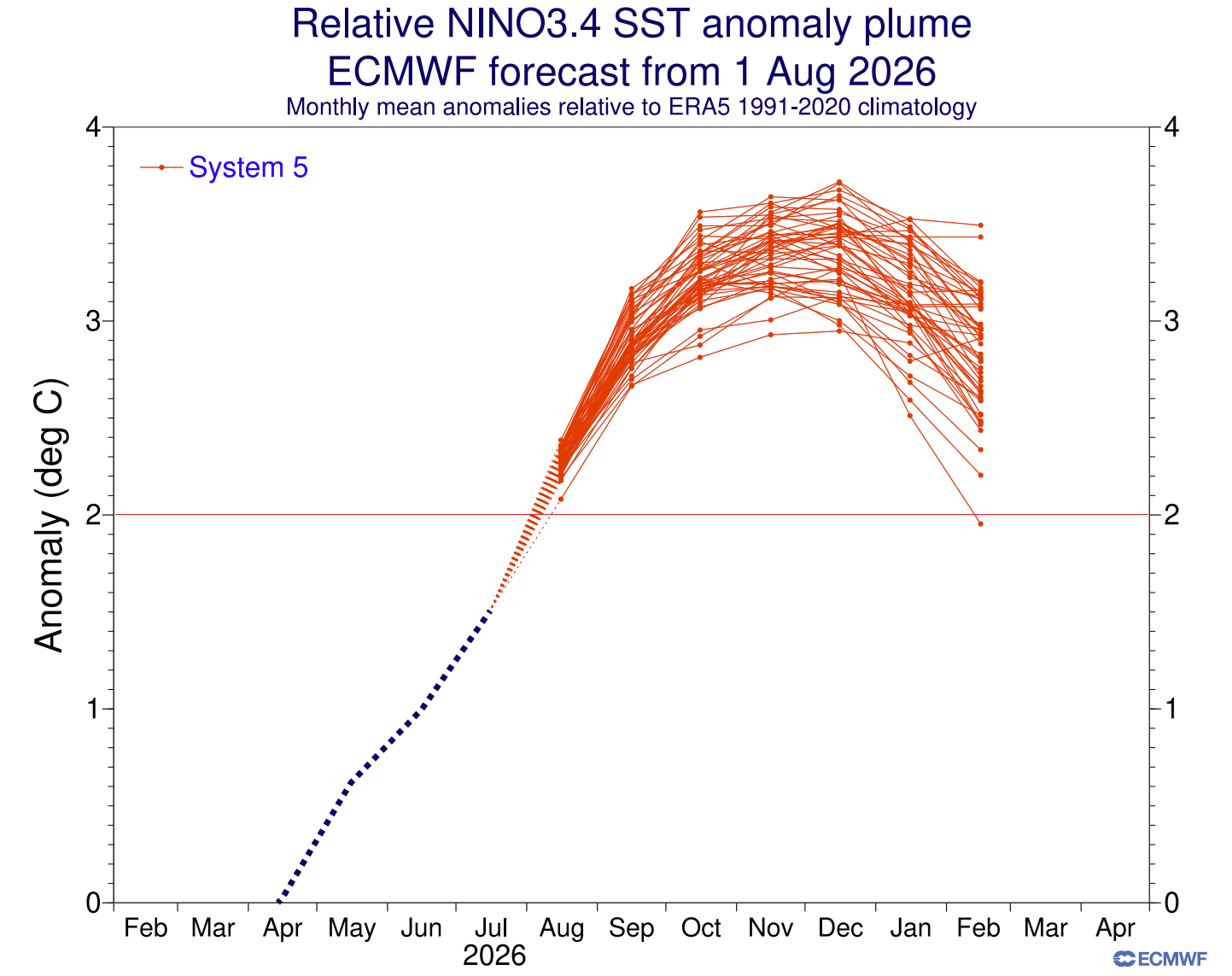
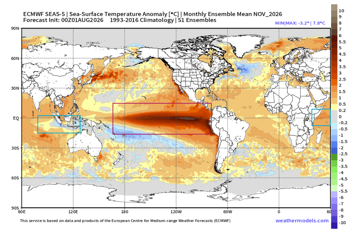
- A Historic Pacific Warming: Subsurface Kelvin waves are pushing sea surface temperature anomalies in the central and eastern Pacific to extreme thresholds, exceeding +3°C to +4°C above normal.
- Dual-Ocean Forcing: The positive IOD introduces a secondary tropical atmospheric cell, establishing a planetary-scale Rossby wave train that amplifies global weather anomalies.
- North American Split-Flow: A high-pressure blocking ridge over Canada is projected to team up with an active southern storm track, creating localized temperature divides and shifting heavy snowfall potential toward the Central and Eastern United States.
- European Westerlies: Europe faces a predominantly mild, wet, and windy winter season driven by a powerful north-to-pressure gradient that enhances Atlantic westerly flow.
Chronology: The Evolution of the 2026/2027 Climate Setup
The foundations of the Winter 2026/2027 outlook began taking shape months prior, driven by shifting trade wind dynamics and subsurface ocean thermal structures.
Spring to Early Summer: Subsurface Kelvin Wave Development
The engine of the current Super El Niño was forged deep beneath the tropical Pacific surface. Strong westerly wind bursts triggered massive Kelvin waves—underwater pulses of warm water—that began migrating eastward across the equatorial Pacific. By early summer, subsurface temperature anomalies within the top 500 meters of the ocean surged to more than 8°C above normal, signaling the birth of an exceptionally strong El Niño event.
Mid-Summer: The Emergence of the Positive IOD
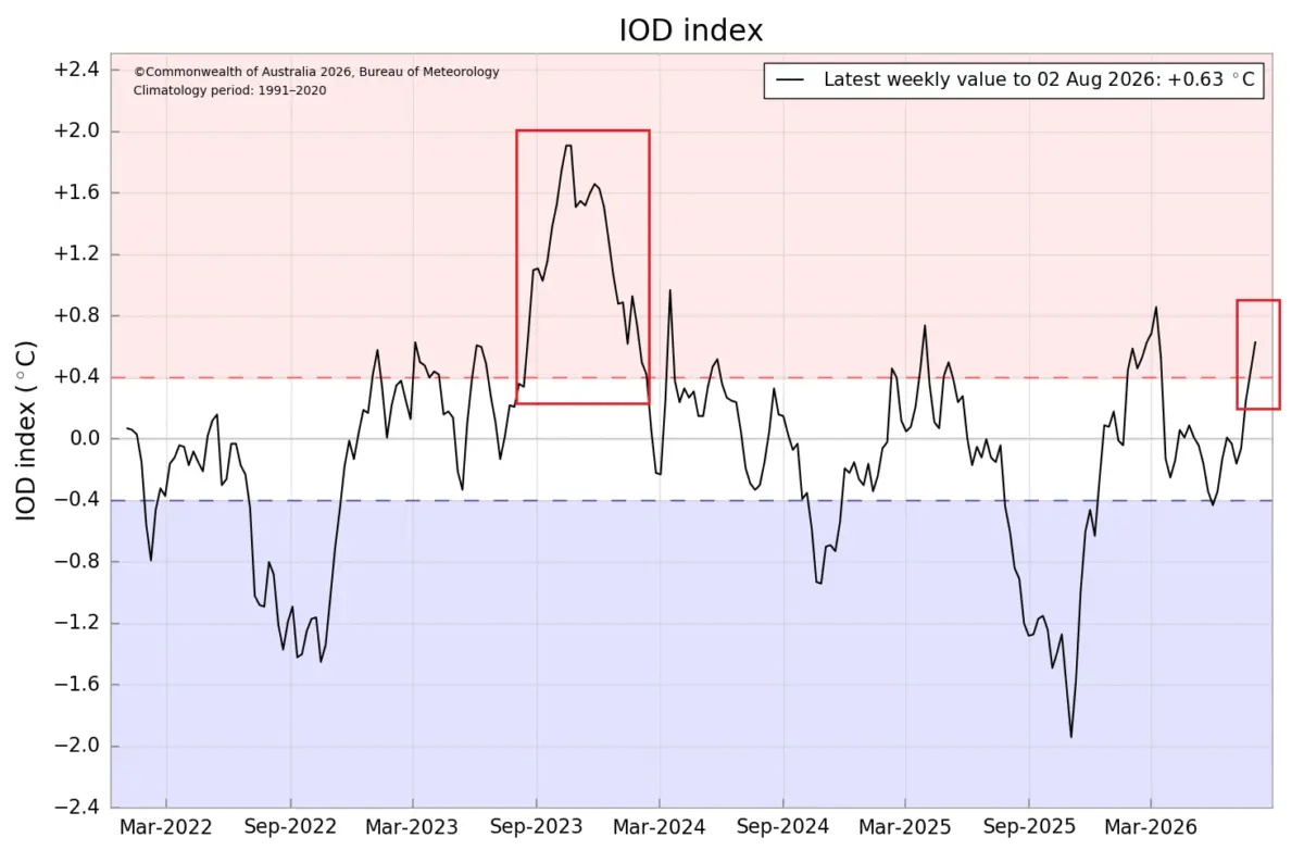
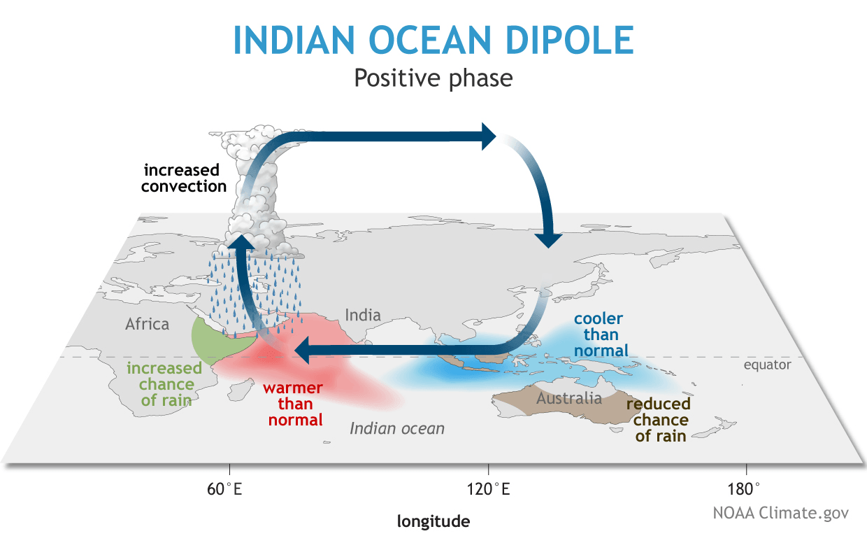
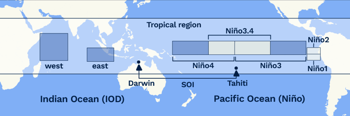
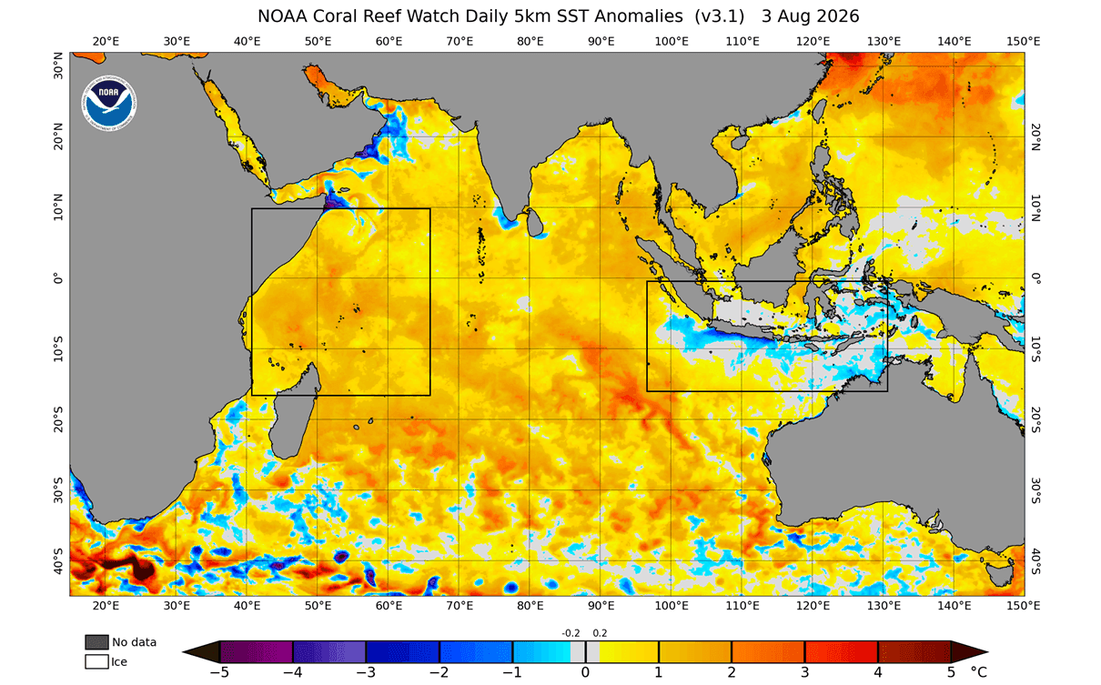
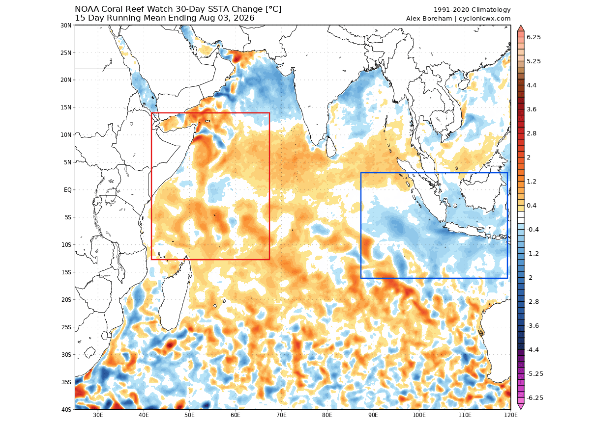
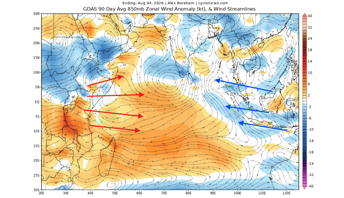
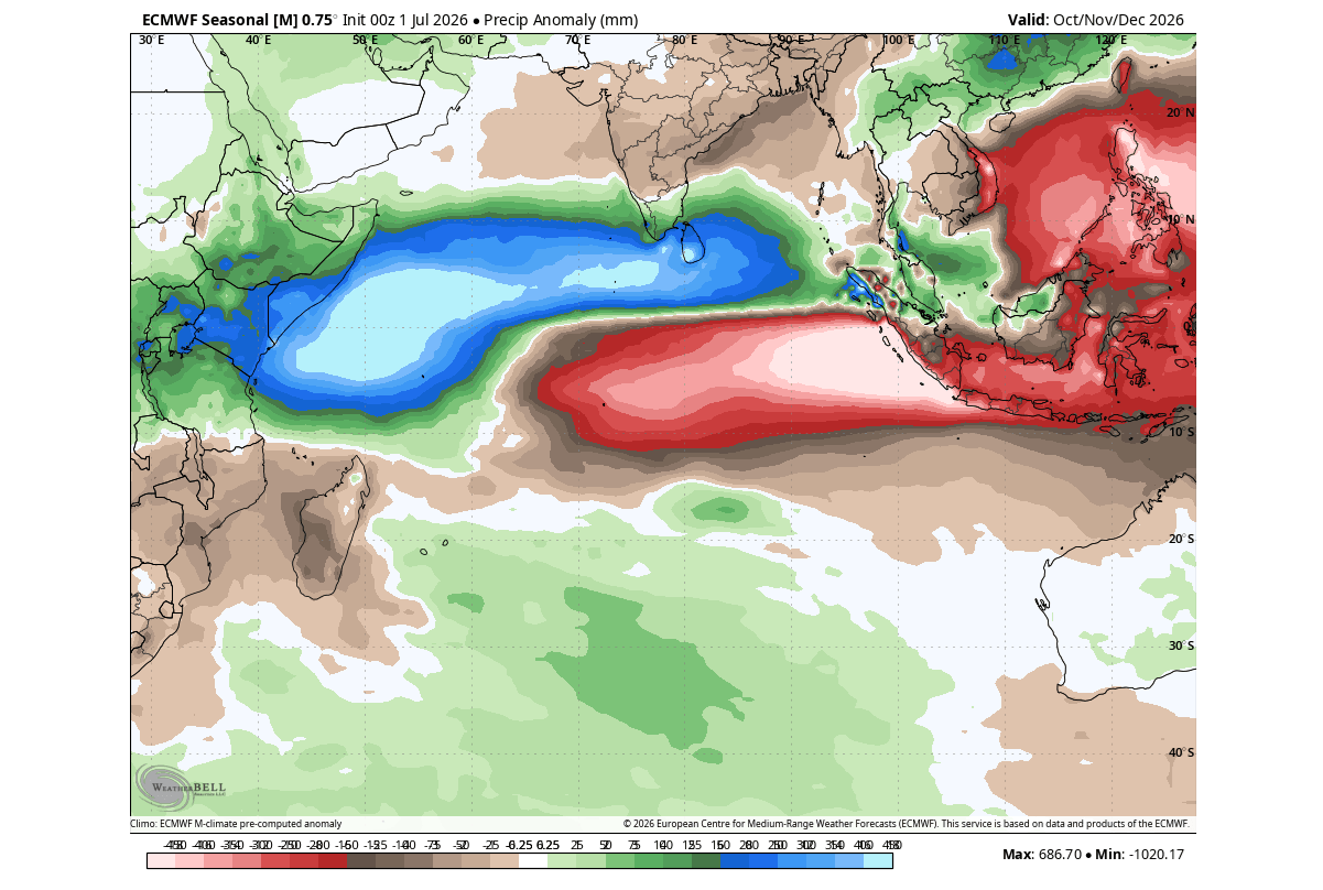
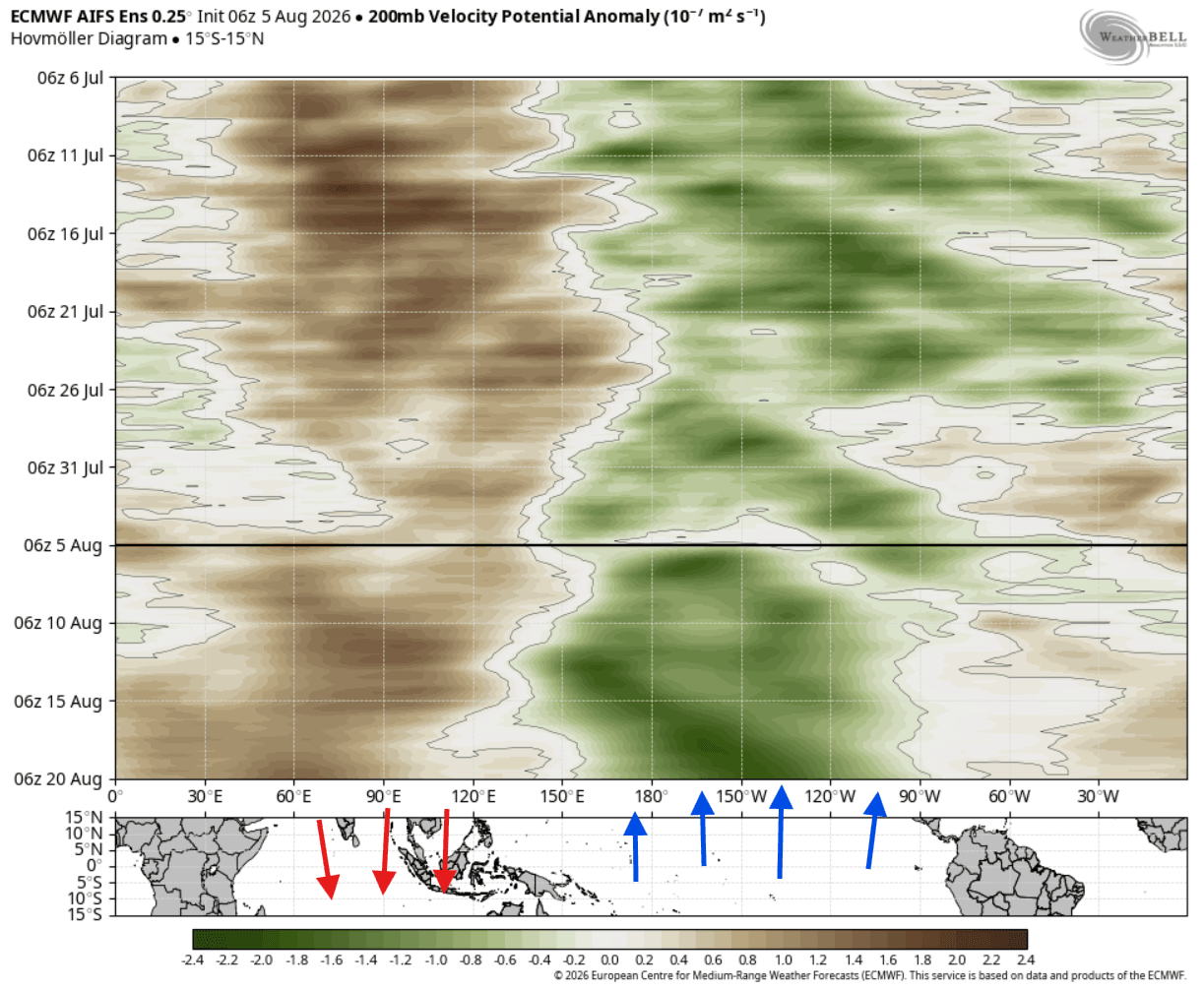
As the Pacific anomaly gathered strength, atmospheric pressure adjustments began altering trade wind patterns across the Indian Ocean. Lower-level zonal wind anomalies revealed a weakening of traditional easterly trade winds in the western Indian Ocean and an intensification in the east. This imbalance initiated a textbook positive Indian Ocean Dipole, characterized by cooler-than-normal sea surface temperatures in the eastern Indian Ocean and warmer waters in the west.
August: The Dual-Ocean Lock and Model Consensus
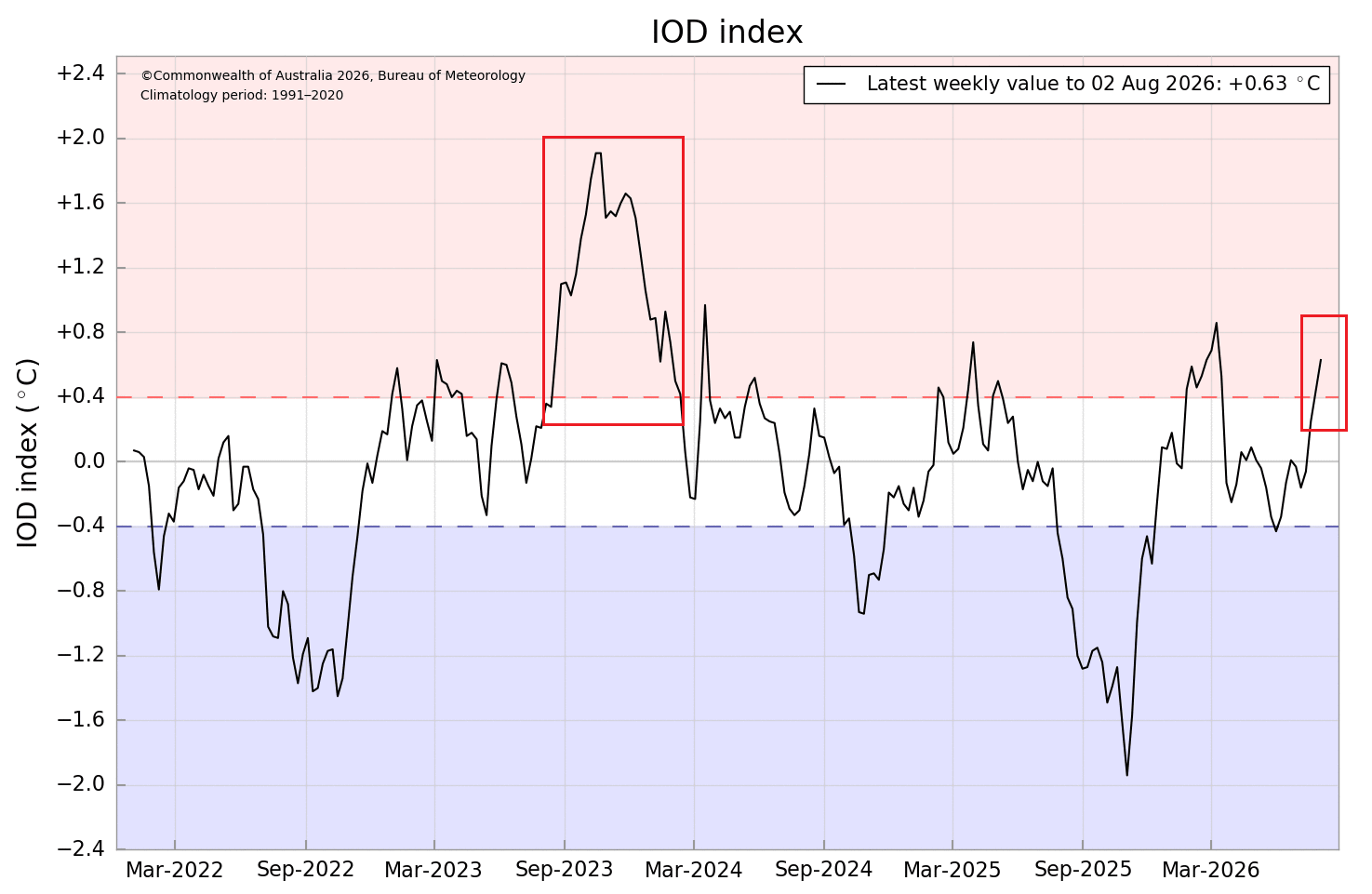
By August, both ocean basins crossed critical operational thresholds. Ocean anomaly analyses confirmed that the positive IOD had firmly entered its active phase, while surface expressions of the Super El Niño began showing peak anomalies exceeding +4°C in the eastern ENSO regions. Multi-model seasonal ensembles from ECMWF and NCEP locked onto this dual forcing, demonstrating that the anomalies would persist through Fall and well into early Winter 2026/2027.
Supporting Data: Analyzing the Tropical and Extratropical Teleconnections
Understanding how tropical ocean temperatures dictate winter weather thousands of miles away requires looking closely at atmospheric motion, pressure anomalies, and historical correlations.
The Tropical Engine: Walker Circulation and Wave Trains
The interaction between the Super El Niño and the positive IOD is mediated by changes in the global Walker circulation—the large-scale tropical atmospheric overturning of air. Persistent rising air over the warm waters of the central Pacific and the western Indian Ocean, coupled with dry, sinking air anchored over Indonesia, acts as a planetary heartbeat.
This configuration launches powerful atmospheric wave trains into the mid-latitudes. According to regression analyses and recent climate studies, a standalone IOD typically generates only minor ripples in the Northern Hemisphere jet stream. However, when paired with a Super El Niño, the combined energy release forces a high-amplitude Rossby wave train across the globe by December.
Historical Precedent: 65 Years of Climate Data
Comparing current projections against 65 years of historical climate data reveals consistent pressure patterns associated with concurrent El Niño and positive IOD events. Historically, this setup favors:
- A North American High-Pressure Ridge: A persistent high-pressure anomaly establishes itself over Canada and the northern tier of the United States.
- An Active Southern Trough: Lower-than-average pressure anomalies carve out a deep path across the southern and eastern United States, guided by an energized southern branch of the jet stream.
Official Responses and Long-Range Forecast Projections
Meteorological agencies and climate prediction centers worldwide have updated their seasonal outlooks to account for the extraordinary strength of the tropical forcing.
North American Winter 2026/2027 Outlook
The ECMWF long-range forecasts for December through February project a classic split-flow regime across North America:
- Temperature Anomalies: Mild, above-normal temperatures are expected to dominate Canada, the Pacific Northwest, and the northern tier of the U.S., insulated by the Canadian blocking high. Conversely, the southern and southeastern United States—stretching from Texas across the Gulf Coast—are favored to experience cooler-than-average conditions due to persistent cloud cover and increased precipitation.
- Precipitation and Storm Tracks: An amplified Pacific jet stream will direct a heavy moisture conveyor belt into California, the Southwest, and across the Southern Plains toward the East Coast.
- Snowfall Trends: Because the primary storm track is displaced further south, seasonal snowfall totals may run below average across the Pacific Northwest, northern Great Lakes, and parts of southern Canada. However, areas where southern moisture intersects periodic drops of Canadian cold air—including the Central Plains, Midwest, Mid-Atlantic, and interior Northeast—face heightened potential for significant winter storms and heavy snowfall anomalies.
European Winter 2026/2027 Outlook
While Europe is traditionally removed from direct tropical forcing, the planetary wave train generated by the dual-ocean system exerts a distinct downstream influence.
- Pressure Patterns: Long-range ensemble runs indicate a pronounced high-pressure anomaly building across southern Europe and the Mediterranean, contrasted with low-pressure systems tracking into northwestern and northern Europe.
- Temperatures and Precipitation: This pressure gradient establishes a robust north-to-south pressure difference, boosting the Atlantic westerly flow. Consequently, the December–February season leans toward above-normal temperatures across much of the continent, accompanied by enhanced precipitation driven by moist maritime air currents.
- Snowfall Potential: Broad, continental-scale snowfall is largely unfavorable under this dominant westerly regime. Widespread snow cover will likely be restricted to higher elevations and the far northern and northeastern reaches of Europe, though individual low-pressure tracking could deliver temporary localized snow events.
Implications for Global Weather and Society
The convergence of a Super El Niño and a positive IOD carries profound implications for agriculture, energy consumption, emergency preparedness, and infrastructure management across the Northern Hemisphere.
- Energy Demand Shifts: Milder winter temperatures across Canada and northern Europe may reduce peak heating demand in those regions, while cooler, stormier conditions across the southern United States could drive localized spikes in energy usage.
- Infrastructure and Transportation: The projected active southern storm track across the U.S. increases the risk of severe winter weather disruptions—including heavy snow, ice storms, and coastal flooding—requiring proactive planning from municipal transit and road maintenance departments.
- Water Resource Management: Enhanced precipitation along the U.S. Gulf and East Coasts, as well as parts of southern Europe, will play a critical role in replenishing regional water reservoirs, though excessive moisture in saturated soils also elevates flood risks.
As global meteorologists continue to refine these models through the autumn transition, communities across North America and Europe are advised to monitor localized updates as the winter season approaches.
